Showing 257 items
matching cypresses
-
 Buninyong & District Historical Society
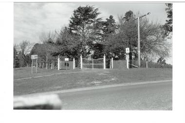
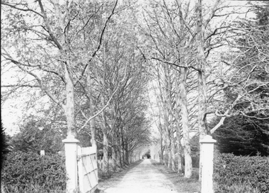
Photograph - Original B/W Photograph, Clive Brooks, Buninyong Botanic Gardens, main gate, Cnr. Scott and Inglis Streets
B/W photo, across intersection to gates on corner of Scott and Inglis Streets, double iron gates with single gates either side, then short length of picket fence. Wire fence down Scott Street to left, wire fence and hedge along Inglis to left. Big Cypress tree centre behind gate, assorted other large trees surrounding.buninyong, botanic gardens, gate, streetscape, trees -
 Southern Sherbrooke Historical Society Inc.
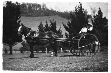
Photograph - Cissie Johns in jinker, c.1913
B&W photo shows Cissie Johns and another person who may be her brother Percy, sitting in a jinker. A dark horse with a white blaze is harnessed to the jinker. Cissie is seated nearest the camera. She is wearing a pale wide-brimmed hat and pale clothing. Her long fair hair is loose around her shoulders. The other person is holding the reins and is wearing a dark hat and pale shirt. This photo may have been taken at the same time as M0104. The subjects are facing south. The sun is shining. They are on a flat expanse of grass. Beyond them are several cypress trees. These are most likely part of the cypress hedges lining the driveway to Glen Park Farm farmhouse. In the background is the eastern flank of Black Hill. A small shed can be seen beside the driveway, partly obscured by the jinker's wheel. Dated c.1913. -
 Glenelg Shire Council Cultural Collection
Photograph - Sheet of 2 black and white contact prints from glass plate negatives, 1960-1970
Sheet of 2 black and white contact prints from glass plate negatives. Measurements are 11.8 x 16.1 cm for both prints. Top: Image of stone house with shingle roof and stone chimneys. Veranda with iron support poles and lacework. Vines growing up poles. (same house as 5622) Front view. Bottom: Man on horse. Cypress pines, wooden fence behind. -
 Whitehorse Historical Society Inc.
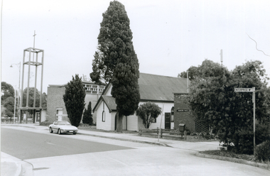
Photograph, Corner Enterprise Way & Edward Street, Mitcham, 2000
Produced as one of a series of 24 prints commissioned by Nunawading & District Historical Society -|Theme: Intersections of Mitcham and Nunawading 2000/2001.|See also Series by P. Simmenauer on the same theme.Black and white photograph - print and negative of corner of Enterprise Way & Edward Street looking South towards Whitehorse Road, Mitcham. L-R: Church Tower [Anglican Church](built circa 1959). Tower surmounts a modern church building in brick and concrete; next door Church Hall 1888 weatherboard construction; Cypress tree; Forster Hall, brick building (circa 1975)forster hall, mitcham, christ church anglican church, church hall -
 Lakes Entrance Historical Society
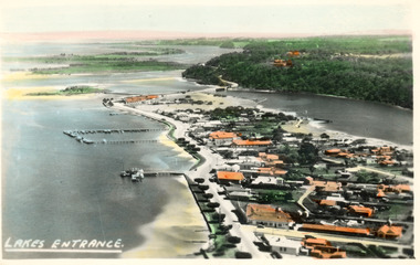
Photograph - Lakes Entrance, 1945c
Two tinted copies, one 8.5 x 13.5 and one 6.5 x 9Black and white postcard showing town, twelve memorial cypress trees and spotting tower on foreshore, post office wharf, boat harbour, Club Hotel at west end of esplanade with five palm trees opposite, causeway to Bullock Island, highway bridge over North Arm, highway up to Jemmys Point, Rigby, Fraser and Flannagan Island's towards Metung. Lakes Entrance VictoriaLakes Entrance islands, aerial photograph, waterways, township -
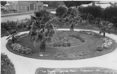 Stawell Historical Society Inc
Photograph, Central Park Gardens --- 2 Photos 1920's, c1910 - 1920
Central Park Gardens. T R G Williams of Ararat Postcard No36. View from Grandstand with Palms and C.E. General, store in Main Street in Background. Additional later similar photograph with two men near palm tree. John Straton's Wool Skin Store, Commission Agent, in background, later purchased by N. Godfrey who came from Rupanyup but lived in St. George St. Stawell. Photo from Ivan Hodder in 1988. Note Picket fence. Black & white Post card by photographer T.R.G. Williams Ararat of The Palms Central Park Stawell 36. Note Cypress hedge removed with view of general store across Lower Main St. c1910-1920 Second photograph taken from the same position c1920 - 1930 with 2 gentleman in lower left of photograph. John Straton's wool & skin store visible in background.Photograph by T.R.G. Williams Ararat stawell, streetscape -
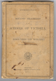 Federation University Historical Collection
Book, Ferdinand von Mueller, Introduction to Botanic Teachings at the Schools of Victoria, 1877, 1877 (exact)
Ferdinand von Mueller was an examiner of botany at the Ballarat School of Mines (SMB) between 1880 and 1888. During that era he was active in donating related items to the School. When the Ballarat School of Mines Council agreed to introduce pharmacy and botany classes in 1879, it was apparent students would require access to botanical specimens in order to further their studies. Council members, who were inspired by the work of Baron Ferdinand von Mueller, authorised development of an area along the School's northern boundary, fronting Lydiard Street South, and oversaw the establishment of the new Botanical Gardens. Baron von Mueller took a practical role the development of SMB's Botanical Gardens from the beginning. He became a generous benefactor who 'donated collections of seeds and leguminous fodder plants, including valued grasses of interest and use to agriculturalists and graziers generally' to SMB over many years. Ferdinand von Mueller's entry on the University of Ballarat Honour Roll can be found at http://www.ballarat.edu.au/curator/honour-roll/honourroll_von_mueller.shtml A light brown, hardcovered book of 152 pages. Chapters include Eucalyptus Trees; Wattles or Acacias; Casuarinas or Sheoaks; Cypress Pines or Sandarac trees; Exocarpos trees of Natice Cherry trees; Mistletoes; Native Honeysuckles or Banksias; Bellflower, Lobelia and Goodenia; Heaths; Correas; Mallow; Buttercups and Clematis; Cruciferous Plants; Mints; Orchids; grasses; ferns. The book has numerous botanical line drawings, and a comprehensive index.Inside front cover "J. Clement Souter M.D."victorian, schools, botany, ferdinand von mueller, von mueller, botanic illustrations, j. clement souter -
 Ringwood and District Historical Society
Photograph, Mrs Lydia Mary Honeyman's home at 82 Ringwood St Ringwood being demolished in June 1970
Mrs Lydia Mary Honeyman's home at 82 Ringwood St Ringwood being demolished, including the enormous Cypress hedge that fronted the road in June 1970.The photos were taken from our property 85 Ringwood St, directly across from the Honeyman property. (The properties were all renumbered when the new police station opened in Ringwood St and we became #97). (Pam Payne) -
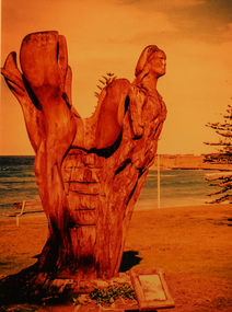 Torquay and District Historical Society
Photograph (copy), Early Torquay Beach Scenes, Circa 2001-2
Photograph shows a tree carving on the esplanade adjacent to the Torquay front beach based on the figurehead of the barque Inverlochy, a Scottish trading ship wrecked off nearby Anglesea on 8 December 1902. The original figurehead had been saved and mounted on a flagpole at Torquay but it disappeared in the 1950s. In 2001-02 local sculptor Mark Trinham carved a replica image of the figurehead into a 80 year old dead cypress tree on the site of the original flagpole. The Inverlochy was one of many ships that ended their seafaring days on the south coast of Victoria.Black and white photographtorquay victoria, wreck of the inverlochy, wood carving -
 Stawell Historical Society Inc
Photograph, “The Sycamores” Driveway entrance Gates
Entrance gates to “The Sycamores” Driveway. A show place on Concongella from mid 1860's. "The Sychmores" where William Osmand lived. Osmand's "Sycamores" was in a secluded block of the eastern side of the creek along which was planted pine and cypress trees. He built a comfortable house and line the carriage way with Sycamores. Osmand was on the of the men who made money in the Stawell reefs mines. "The Sycamores" has been owned by the West family since c 1920. Black & white photograph (2 copies) of an entrance gateway with an avenue of deciduous trees.concongella -
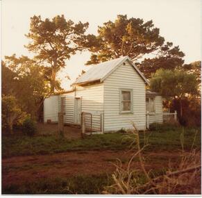 Phillip Island and District Historical Society Inc.
Photographs, 1978-9
House built by Mr Joseph Richardson about 1870 at Ventnor on the corner of what is now The Nobbies and Graydens Road. Lived in by several well known families.Four Photographs of a Timber house with corrugated iron roof. 81-84 Rain water tank. Note wooden door. Fence surround and gate. 81-84a Possibly back view of the house with verandah on end. 81-84b Bullnose verandah, brick chimney. Note roof and cypress trees in background and ?wattle bushes in foreground. 81-84c Looks as though a sleepout or bathroom was added on end of verandah. rubbish in foreground.local history, photographs, buildings - historic, coloured photograph, john cook, phillip island, richardson -
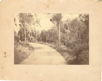 Bendigo Historical Society Inc.
Photograph - BOTANICAL GARDENS
sepia photograph on cream board. Driveway/pathway, gravelled, eucalypt and conifer trees, uncut grass, wire fence middle distance. Pathway curving to left from front of photo. Written in blue pen on rear of photo : Botanical Gardens or early path in Fortuna. English trees planted, e.g. cypress. Holdsworth Road, adj. White Hills Cemetery Reserve. Crowned road grade. Heavy intermediate fence posts.unknownplace, land, botanical gardens, fortuna ? -
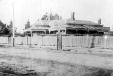 Surrey Hills Historical Society Collection
Photograph, 215 Union Road, c 1920
The house was variously known as ‘Mintaro’, ‘Montiere’ and ‘Goonoo Goonoo’, the later after 1920 when it was purchased by Natale Cerini and his wife Ethel May (nee Swan), who were married in 1918. Built 1887-1888 by William Wigley. The original colour was deep cream with dark green trim. Property included a block of land on south side and also land to the north. The original coach house was on what became 213 Union Road and was used to build a yacht in by the then neighbours, the Flemings. The street plane trees were replaced in the 1970s with melaleucas and in 1987 new plane trees were planted between the melaleucas. Sepia copy of an older photo of 215 Union Road from diagonally across the road. Shows street surface, bluestone kerbing, a young tree within a guard and a Victorian style home with 3 chimneys, a slate roof and a veranda on at least the south and west side. Beyond the house are mature cypress and other trees and a spire. The spire belonged to Surrey College, a boys' boarding school (later Nethercourt Hospital and St Judes.)'mintaro', 'montiere', 'goonoo goonoo', william wigley, mrs ethel may cerini, miss ethel may swan, miss jocelyn cerini, mrs jocelyn hall, miss lynette cerini, victorian style, 215 union road -
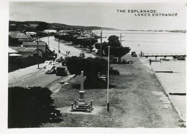 Lakes Entrance Historical Society
Postcard - Esplanade Lakes Entrance, 1945c
Original from wallet of miniature postcards produced by Bulmer, two copies. 01419.1 and .2 Also two enlargements 17 x 25 cmBlack and white small format postcard of Esplanade, taken from the WW2 Air Observers Spotting Tower. In the foreground is the Cenotaph erected 1922 on the grass verge between road and lake. Trimmed WW1 Cypress trees also on verge. Cars and truck on highway all travelling in easterly direction. Houses and businesses on north side of road, Princes Highway, which follows the margin of the lake shore. Lakes Entrance VictoriaThe Esplanade Lakes Entrancetownship, waterfront, transport, world war 1939 - 1945, world war 1914-1918 -
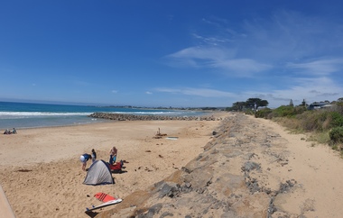
 Ballarat Heritage Services
Photograph, Clare Gervasoni, Apollo Bay, Victoria, 24/01/2022
In 2021, the Department of Environment, Land, Water and Planning (DELWP) constructed two new groynes and a section of rock seawall at Apollo Bay to help manage the impacts of coastal erosion. The new 70-meter-long rock groynes run perpendicular to the shoreline and be located just south of the Milford St revetment and to the south of Milford Creek. Sections of rock seawall will be constructed between the two Groynes with an aim to protect the dune, walking path, cypress trees and road from erosion. Colour photograph of a coastal scene at Apollo Bay, featuring new rock groynes to protect the Great Ocean Road from erosion. apollo bay, beach, coast, groyne, rockwall -
 Ballarat Heritage Services
Photograph, Clare Gervasoni, Apollo Bay, Victoria, 24/01/2022
In 2021, the Department of Environment, Land, Water and Planning (DELWP) constructed two new groynes and a section of rock seawall at Apollo Bay to help manage the impacts of coastal erosion. The new 70-meter-long rock groynes run perpendicular to the shoreline and be located just south of the Milford St revetment and to the south of Milford Creek. Sections of rock seawall will be constructed between the two Groynes with an aim to protect the dune, walking path, cypress trees and road from erosion. Colour photograph of a coastal scene at Apollo Bay, featuring new rock wall and groynes to protect the Great Ocean Road from erosion. apollo bay, beach, coast, groyne, rockwall -
 Ballarat Heritage Services
Photograph, Clare Gervasoni, Sea Wall at Apollo Bay, Victoria, 24/01/2022
In 2021, the Department of Environment, Land, Water and Planning (DELWP) constructed two new groynes and a section of rock seawall at Apollo Bay to help manage the impacts of coastal erosion. The new 70-meter-long rock groynes run perpendicular to the shoreline and be located just south of the Milford St revetment and to the south of Milford Creek. Sections of rock seawall will be constructed between the two Groynes with an aim to protect the dune, walking path, cypress trees and road from erosion. Colour photograph of a coastal scene at Apollo Bay, featuring new rock wall and groynes to protect the Great Ocean Road from erosion. apollo bay, beach, coast, groyne, rockwall, sea wall -
 Southern Sherbrooke Historical Society Inc.
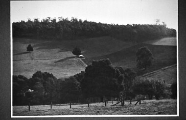
Photograph - Glen Park Farm, Selby
B&W photo showing Glen Park Farm, Selby, owned by the Johns family, as seen from the north-east corner. Photo shows the descent to the valley then up Black Hill in the background. Mostly cleared paddock apart from the cypress avenue to the farmhouse (which is glimpsed between the trees) a few single trees dotted about, and the heavily treed area on the top of Black Hill. There is a small building or shed or possibly a haystack in the centre of the photo. -
 Greensborough Historical Society
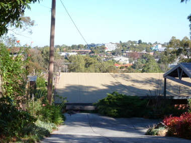
Photograph - Digital image, View of Greensborough from Delfin Crescent, 02/05/2013
This photograph of Greensborough was taken from Delfin Crescent in 2013 to show changes over 40 years, based on Ron Reynold’s sketches in the 1973 publication “Greensborough and Greenhills” published by Cypress Books. Delphin Crescent [previously known as Medhurst Street] was created about 1970 in association with the Delfin Building Company. It was at this time also, that major works on Diamond Creek Road raised the level of the road facilitating the connection of Delfin Crescent with Diamond Creek Road. [Note: 'Medhurst Street was only listed on planning maps pre 1950 when the 'street' had no residents or development.]Digital copy of colour photograph.greensborough and greenhills -
 Surrey Hills Historical Society Collection
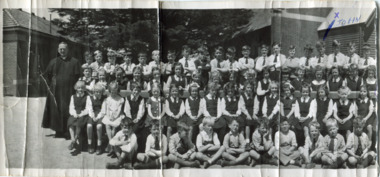
Digital photo, Our Holy Redeemer school photo, late 1950s, 1950s
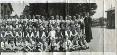
School history - ref https://ourholyredeemer.cam.org.au/history In 1904 Fr. George Robinson erected a weatherboard school-hall where the present hall now stands. It was blessed and opened by Archbishop Carr on 20th November of that year. In January 1905, the Sisters of St Joseph took charge of the school. Archbishop Mannix opened and blessed the new brick school on 10th November 1918. From 1941-1972, Fr Tim Fitzpatrick was parish priest and head of the school. He is the priest on the LHS of this large school photo. Personal history: Although they lived in Prospect Street, Box Hill, John and Mary Turnbull attended Our Holy Redeemer School, as did Susan Hirst who lived across the road from the Turnbull family with her parents Ray and Shirley Hirst at 29 Prospect Street.Part of a large landscape black and white photo of a priest with a large group of children grouped as follows: Back row: 20 boys Second back row: 21 girls Second row: 16 girls Front row: 10 boys. Behind the group is a large cypress tree and to either side the church and (?) school building. The boy 4th from the right in the back row is marked with an 'x' in blue biro. This is part of a large landscape photo. The 2 pieces should be viewed as one. On front 'x' in blue biro is believed by the donor to have been made by Hughn Turnbull, his father. On rear in blue biro: "X JOHN" and " T MARY" plus in black in John Turnbull's hand "(MY SISTER)"; "SUSAN HIRST / SH (crossed out) / 3rd from RIGHT END" The donor has indicated that his father made the markings on the front of the photo. schools, our holy redeemer school, fr tim fitzpatrick, john turnbull, mary turnbull, susan hirst -
 Surrey Hills Historical Society Collection
Photograph, View of Surrey Gardens looking east from Union Road
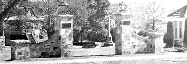
The 2 cannons in the gardens were acquired by Mr Arthur Brookes, popularly known as 'Empire Brookes'. They were from a British vessel used during the Crimean War and were originally placed in the grounds of the Guildford Road Recreation Oval. The Dimmick Gateway was erected in 1950 by the citizens of Camberwell in memory of Cr William Dimmick, JP, Mayor of Camberwell, 1935-1936 and a Councillor from 1934-1947. There is a photo of him in Mayoral robes in the City of Boroondara Library Service collection. Cr Dimmick was commonly called Roy.Black and white photo of the Dimmick Gateway in Surrey Gardens. The gateway is built as if it was designed to have a fence attached but there is none. There are 2 tall central pillars and an arched bridge to 2 smaller pillars. It appears to be constructed from a variegated slate material. There is a light on the top of each of the tall pillars and also a plaque. To the RHS of the photo is part of the Surrey Shrine, skirted by 2 cypress trees. A canon and the Memorial Cross can be seen between the gateway pillars and to the LHS of the photo the wooden bandstand can be seen.dimmick gateway, surrey gardens, surrey shrine, boer war, bandstand, parks and reserves, cr william dimmick, roy dimmick -
 Ballarat and Queen's Anglican Grammar School
Badge, Noopsi Badges celebrating 100 years of Anglican education
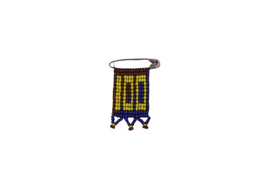
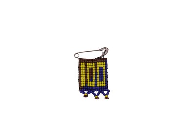
Ballarat Grammar’s 23 acre site facing Forest and Howitt Streets, Wendouree was chosen carefully by the Committee set up by the Church Assembly (Synod) in November 1908. Classes began for the 38 boys enrolled on 14 February 1911. The first building accommodated 90 day boys and 25 boarders. It comprised the Headmaster’s residence, three classrooms, one large dormitory, a small bathroom, two cubicles for assistant masters and the matron’s room. During the first year the property was fenced, trees and cypress hedges were planted, a carriage drive was constructed and work commenced for the School Cricket Oval. Three Noopsi Badges celebrating 100 years of Anglican education at Ballarat & Queens Anglican Grammar School. These are beaded badges in blue, yellow and brown with "100" in yellow, mounted on a safety pin. "100" in worked in yellow beadsballarat, badge, queens, 100, cegs, 2011, bgs, noopsi, century-celebration, grammar-school, qceggs -
 Ballarat and Queen's Anglican Grammar School
Badge, Noopsi Badges celebrating 100 years of Anglican education
Ballarat Grammar’s 23 acre site facing Forest and Howitt Streets, Wendouree was chosen carefully by the Committee set up by the Church Assembly (Synod) in November 1908. Classes began for the 38 boys enrolled on 14 February 1911. The first building accommodated 90 day boys and 25 boarders. It comprised the Headmaster’s residence, three classrooms, one large dormitory, a small bathroom, two cubicles for assistant masters and the matron’s room. During the first year the property was fenced, trees and cypress hedges were planted, a carriage drive was constructed and work commenced for the School Cricket Oval. Three Noopsi Badges celebrating 100 years of Anglican education at Ballarat & Queens Anglican Grammar School. These are beaded badges in blue, yellow and brown with "100" in yellow, mounted on a safety pin. "100" in worked in yellow beadsballarat, badge, queens, 100, cegs, 2011, bgs, noopsi, century-celebration, grammar-school, qceggs -
 Surrey Hills Historical Society Collection
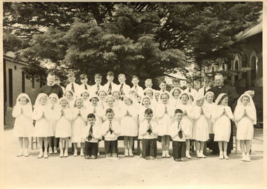
Digital photo, Our Holy Redeemer First Communion class, 1951, 1951
According to the donor, Fr Fitzpatrick is the priest on the RHS of the Communion group.This is one of a series of photos that document John Turnbull’s First Communion. They are representative of this important rite of passage in the Catholic Church in the 1950s. The sacrament of First Communion is an important tradition for Catholic families and individuals. Originally this was celebrated when a child was 10, 12 or even 14 years of age, however in 1910, Pope Pius X issued the decree Quam singulari, which changed the age at which First Communion is taken to 7 years old. Traditions of celebration surrounding First Communion usually include family gatherings and parties to celebrate the event. The first communicant wears special clothing. The clothing is often white to symbolize purity. It is more elaborate for girls but boys wear ‘Sunday best’; it could be a suit and tie or even a tuxedo. Many families have formal professional photographs taken in addition to candid snapshots in order to commemorate the event and some churches arrange for a professional photographer to attend after the ceremony. A black and white photo of 16 visible boys (plus one additional boy almost completely obscured to the right of the group), 23 girls and 2 priests. The boys are wearing shorts and white shirts with ties. The girls are wearing white dresses and veils. The children are grouped with 12 boys in the back row and 4 kneeling in the front. The girls are in the front and centre rows and the priests are either side of the group. Behind the group is a large cypress tree and to either side the church and (?) school building. One of the boys is John Turnbull. On rear in black ink: "John's 1st COMMUNION / 1951 / JOHN IS BACK ROW / 2ND FROM LEFT". our holy redeemer church, our holy redeemer school, john turnbull, fr tim fitzpatrick, first communion, children -
 Surrey Hills Historical Society Collection
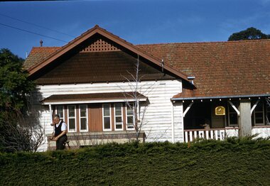
Photograph - Digital photograph, George L Coop, 688 Whitehorse Road, Mont Albert 1958, 1958
The gentleman in the photo is George Burton Coop, an architect / draughtsman. The donor, his son George Lister Coop was about 21 years of age when he took this photo in 1958 of his family home. His parents were: George Burton Coop (b c1906 Williamstown; died aged 54 years at Mont Albert) and Winsome Alice (MS: Trewartha) who married in 1936. They are first listed at this address in the electoral roll in 1937. They had 2 children: George Lister Coop - born St Georges Hospital, 8/10/1937 and Alison - born c1945. However the donor informed that he initially attended Chatham State School because his first home was the Spanish Mission style flats at 346 Whitehorse Road, opposite Brenbeal Street, Balwyn. When his grandparents died, the family moved to 688 Whitehorse Road and he then attended Mont Albert Central School. Alison being younger did not go to Chatham Primary. A digital copy of a colour photo showing detail of the front view of 688 Whitehorse Road. The house is white weatherboard in a Californian bungalow style with a tiled roof and shingles detail in a dark brown stain. The balustrades and finials of the veranda are simple with occasional feature planks with a tulip detail. A bird cage hangs from the veranda. The veranda is supported by rough-cast sturdy pillars. The house sits behind a cypress hedge. The photo was taken in winter as deciduous shrubs are bare. A gentleman astride a ladder is pruning the hedge. george l coop, whitehorse road, mont albert, californian bungalow, cypress hedge, gardening, george burton coop -
 University of Melbourne, Burnley Campus Archives
Photograph - Black and white print, Miscellaneous Photographs
trees, garden views, fruit tree pruning, lagoon paddock, orchard, principals residence, pinus canariensis, sequoia sempervirens, pinus radiata, butia capitata, emily gibson bed -
 Surrey Hills Historical Society Collection
Photograph, Chatham students support the Empire, Surrey Hills, c 1947, 1947
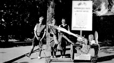
The billycart was possibly decorated for celebrations associated with Empire Day. Image was originally copied by Chatham Primary School for inclusion in their pictorial history "A Patchwork of People - Chatham Past and Present" [ISBN 0 646 29370 2], by Susan Barnett and Julia Ashby, published in 1996 for the school's 70th anniversary. Copied for the SHNCHC with the school and donor's permission. There is also a laminated copy of it for display purposes.Black and white image of four boys and their billycart. Two are identified as Bruce Hansen, standing behind the flag and Jimmy Boyd, seated in the billycart, which is decorated with streamers, an English flag and advertising signs promoting Australian sultanas and the export of Australian dried fruit to the [British] Empire. The photo was taken in the grounds of Chatham Primary School. In the background can be seen some of the cypress trees that were planted along the side of the oval, a remnant eucalypt from the time when the land was part of J B Maling's farm and part of the shelter shed.chatham primary school, billycarts, advertising signs, empire day, bruce hansen, jimmy boyd -
 Surrey Hills Historical Society Collection
Digital photo, Our Holy Redeemer school photo, late 1950s (Part 2), 1950s
School history - ref https://ourholyredeemer.cam.org.au/history In 1904 Fr. George Robinson erected a weatherboard school-hall where the present hall now stands. It was blessed and opened by Archbishop Carr on 20th November of that year. In January 1905, the Sisters of St Joseph took charge of the school. Archbishop Mannix opened and blessed the new brick school on 10th November 1918. From 1941-1972, Fr Tim Fitzpatrick was parish priest and head of the school. Personal history: Although they lived in Prospect Street, Box Hill, John and Mary Turnbull attended Our Holy Redeemer School, as did Susan Hirst who lived across the road from the Turnbull family with her parents Ray and Shirley Hirst at 29 Prospect Street.Part of a large landscape black and white photo of a priest with a large group of children grouped as follows: Back row: 19 boys Second back row: 14 girls Second row: 15 girls Front row: 12 boys. Behind the group is a large cypress tree and to either side the church and (?) school building. The girl in the 2nd row, first on the left is marked with an 'T' in blue biro; the girl 3rd from the right in the same row is circled in blue biro. There is a Californian bungalow in the background. This is half of a large landscape photo and the 2 pieces should be viewed together. On front 'T' and a circle in blue biro are believed by the donor to have been made by Hugh Turnbull, his father. On rear in black: "OUR HOLY REDEEMER - SURREY HILLS / PROBABLY 1950's" schools, our holy redeemer school, fr tim fitzpatrick, john turnbull, mary turnbull, susan hirst