Showing 382 items matching "dandenong creek"
-
 Marysville & District Historical Society
Document (item) - Historic Site Register Sheet, Parks Victoria, Historic Site Recording System-Site Register Sheet-Chester & Locke Mine, 1989
A copy of a historic site register sheet for the Chester and Locke gold mine near Marysville in Victoria.A copy of a historic site register sheet for the Chester and Locke gold mine near Marysville in Victoria. The Golden Bower gold mine was a quartz reef mine. William Edward Chester discovered the Golden Secret gold vein which became part of the Golden Bower Mine at Chesterville near Donovans Creek on the Cumberland goldfield which he mined with George Locke until the late 1930s. chester and locke mine, william chester, george locke, cambarville, yarra ranges, walker's hotel, marysville, victoria -
Marysville & District Historical Society
Document (item) - Letter, Andrew Kirwan mining-Wolfram & Gold at Cumberland River, 09-07-1981
A letter outlining the history of Andrew Kirwan who was a gold miner and road worker in Marysville in Victoria.A letter outlining the history of Andrew Kirwan who was a gold miner and road worker in Marysville in Victoria. Andrew Kirwan, along with his brothers, located and worked the Wolfram Mine at Wilkes Creek where they mined tungsten.andrew kirwan, marysville, victoria, cumberland valley, wolfram mine, wilkes creek, anderson and rowe sawmill, cumberland creek, golden bower gold mine, william chester, maria catherine kirwan, kirwan's reward, tungsten, cumberland river -
 Marysville & District Historical Society
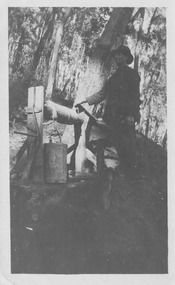
Photograph (item) - Black and white photograph, Unknown
An early black and white photograph taken at the Golden Bower in the Cumberland Valley in Victoria.An early black and white photograph taken at the Golden Bower Mine in the Cumberland Valley in Victoria. The Golden Bower gold mine was a quartz reef mine. William Edward Chester discovered the Golden Secret gold vein which became part of the Golden Bower Mine at Chesterville near Donovans Creek on the Cumberland goldfield which he mined with George Locke until the late 1930s. golden bower gold mine, cumberland valley, victoria, quartz reef mining, water-powered battery, william edward chester, george locke, chesterville, donovan's creek, cumberland goldfield -
 Marysville & District Historical Society
Photograph (item) - Black and white photograph, Unknown
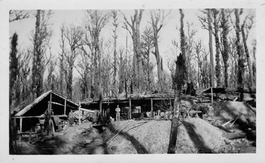
An early black and white photograph of the blacksmith's forge at the Golden Bower mine in the Cumberland Valley in Victoria.An early black and white photograph taken at the Golden Bower Mine in the Cumberland Valley in Victoria. The Golden Bower gold mine was a quartz reef mine. William Edward Chester discovered the Golden Secret gold vein which became part of the Golden Bower Mine at Chesterville near Donovans Creek on the Cumberland goldfield which he mined with George Locke until the late 1930s. golden bower gold mine, cumberland valley, victoria, quartz reef mining, water-powered battery, william edward chester, george locke, chesterville, donovan's creek, cumberland goldfield -
 Marysville & District Historical Society
Photograph (item) - Black and white photograph, Unknown
An early black and white photograph of the Golden Bower mine in the Cumberland Valley in Victoria.An early black and white photograph taken at the Golden Bower Mine in the Cumberland Valley in Victoria. The Golden Bower gold mine was a quartz reef mine. William Edward Chester discovered the Golden Secret gold vein which became part of the Golden Bower Mine at Chesterville near Donovans Creek on the Cumberland goldfield which he mined with George Locke until the late 1930s. golden bower gold mine, cumberland valley, victoria, quartz reef mining, water-powered battery, william edward chester, george locke, chesterville, donovan's creek, cumberland goldfield -
 Marysville & District Historical Society
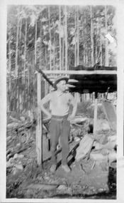
Photograph (item) - Black and white photograph, Unknown
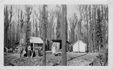
An early black and white photograph of the Golden Bower mine camp in the Cumberland Valley in Victoria.An early black and white photograph taken at the Golden Bower Mine in the Cumberland Valley in Victoria. The Golden Bower gold mine was a quartz reef mine. William Edward Chester discovered the Golden Secret gold vein which became part of the Golden Bower Mine at Chesterville near Donovans Creek on the Cumberland goldfield which he mined with George Locke until the late 1930s. golden bower gold mine, cumberland valley, victoria, quartz reef mining, water-powered battery, william edward chester, george locke, chesterville, donovan's creek, cumberland goldfield -
 Marysville & District Historical Society
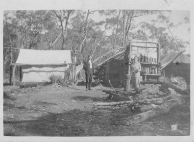
Photograph (item) - Black and white photograph, Unknown
An early black and white photograph taken at the Golden Bower Mine Camp in the Cumberland Valley in Victoria.An early black and white photograph taken at the Golden Bower Mine in the Cumberland Valley in Victoria. The Golden Bower gold mine was a quartz reef mine. William Edward Chester discovered the Golden Secret gold vein which became part of the Golden Bower Mine at Chesterville near Donovans Creek on the Cumberland goldfield which he mined with George Locke until the late 1930s. golden bower gold mine, cumberland valley, victoria, quartz reef mining, water-powered battery, william edward chester, george locke, chesterville, donovan's creek, cumberland goldfield -
 Marysville & District Historical Society
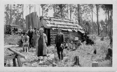
Photograph (item) - Black and white photograph, Unknown
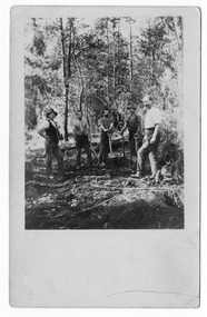
An early black and white photograph taken at the Golden Bower Mine in the Cumberland Valley in Victoria.An early black and white photograph taken at the Golden Bower Mine in the Cumberland Valley in Victoria. The Golden Bower gold mine was a quartz reef mine. William Edward Chester discovered the Golden Secret gold vein which became part of the Golden Bower Mine at Chesterville near Donovans Creek on the Cumberland goldfield which he mined with George Locke until the late 1930s. golden bower gold mine, cumberland valley, victoria, quartz reef mining, water-powered battery, william edward chester, george locke, chesterville, donovan's creek, cumberland goldfield -
 Marysville & District Historical Society
Postcard (item) - Black and white postcard, Unknown
An early black and white photograph taken at the Golden Bower Mine in the Cumberland Valley in Victoria.An early black and white photograph taken at the Golden Bower Mine in the Cumberland Valley in Victoria. The Golden Bower gold mine was a quartz reef mine. William Edward Chester discovered the Golden Secret gold vein which became part of the Golden Bower Mine at Chesterville near Donovans Creek on the Cumberland goldfield which he mined with George Locke until the late 1930s. POST CARD EMPIRE FOR CORRESPONDENCE FOR ADDRESS ONLY STAMPgolden bower gold mine, cumberland valley, victoria, quartz reef mining, water-powered battery, william edward chester, george locke, chesterville, donovan's creek, cumberland goldfield, postcard, souvenir -
 Marysville & District Historical Society
Postcard (item) - Black and white postcard, Unknown
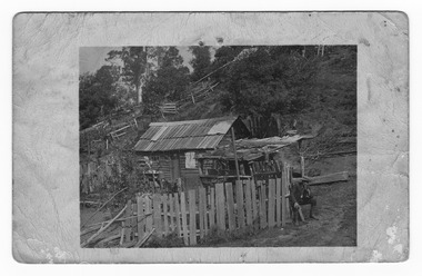
An early black and white photograph taken at the Golden Bower Mine Camp in the Cumberland Valley in Victoria.An early black and white photograph taken at the Golden Bower Mine Camp in the Cumberland Valley in Victoria. The Golden Bower gold mine was a quartz reef mine. William Edward Chester discovered the Golden Secret gold vein which became part of the Golden Bower Mine at Chesterville near Donovans Creek on the Cumberland goldfield which he mined with George Locke until the late 1930s. POST CARD CORRESPONDENCE. ADDRESS ONLY. KODAK/ AUSTRALIA 30/06/10 Rose Hill/ Fitzwilliam Street/ Kew Should have written/ to you months ago about the/ photos I took at Easter./ Sorry to say the one of the little/ girls was no good I expect/ you will recognise both these/ places/ K McDowell Mrs Fletcher/ Golden Bower Mine/ Via Marysville J Mahoneygolden bower gold mine, cumberland valley, victoria, quartz reef mining, water-powered battery, william edward chester, george locke, chesterville, donovan's creek, cumberland goldfield -
 Marysville & District Historical Society
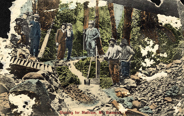
Photograph (item) - Colour tinted photograph, Sluicing for Wolfram, Mt. Bismark, 1908
An early colour tinted photograph taken at the Wilks Creek wolfram mine near Marysville in Victoria.An early colour tinted photograph taken at the Wilks Creek wolfram mine near Marysville in Victoria. The first discovery of wolfram in this location was in 1894. The first claims were lodged in 1908 and then with the start of World War I the value of tungsten increased and more claims were lodged and worked. After the war the use for tungsten diminished and the mine was abandoned until World War II when tungsten again became a valuable commodity. However due to difficulties encountered in the mining of the tungsten at the Wilks Creek mine, it was unable to pay its way and at the end of 1943 the mine closed. The viability of mining wolfram at Wilks Creek was again reviewed in the 1960s but with little success. Once again, in 1980 it was reported that there would still be wolfram to be mined but the environmental impact to an area of outstanding natural beauty was deemed to be too great to continue with the project.wilks creek, wolfram mine, wolfram, tungsten, marysville, victoria, mt bismark, wood's point -
 Marysville & District Historical Society
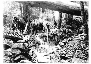
Photograph (item) - Colour tinted photograph, 1908
An early black and white photograph taken at the Wilks Creek wolfram mine near Marysville in Victoria.An early black and white photograph taken at the Wilks Creek wolfram mine near Marysville in Victoria. The first discovery of wolfram in this location was in 1894. The first claims were lodged in 1908 and then with the start of World War I the value of tungsten increased and more claims were lodged and worked. After the war the use for tungsten diminished and the mine was abandoned until World War II when tungsten again became a valuable commodity. However due to difficulties encountered in the mining of the tungsten at the Wilks Creek mine, it was unable to pay its way and at the end of 1943 the mine closed. The viability of mining wolfram at Wilks Creek was again reviewed in the 1960s but with little success. Once again, in 1980 it was reported that there would still be wolfram to be mined but the environmental impact to an area of outstanding natural beauty was deemed to be too great to continue with the project.wilks creek, wolfram mine, wolfram, tungsten, marysville, victoria, mt bismark, wood's point -
 Marysville & District Historical Society
Photograph (Item) - Black and white photograph, Bridge Over The Cumberland, c1900
An early black and white photograph of a bridge over the Cumberland Creek near Marysville in Victoria.An early black and white photograph of a bridge over the Cumberland Creek near Marysville in Victoria. The Cumberland Creek is in the Cumberland Valley near Cambarville which was a timber town near Marysville. Cambarville is notable for its giant mountain ash (Eucalyptus regnans) trees within the Cumberland Memorial Scenic Reserve, and relics from former sawmills and gold mining. The Big Culvert is located nearby on the Marysville - Woods Point Road, which was historically part of the Yarra Track. Cambarville was established as a timber mill town in the 1940s. Timber mill owners A Cameron and FJ Barton named Cambarville. They established the mill to salvage timber from trees destroyed in the 1939 bushfires. Cambarville was impacted by the 2009 Black Saturday bushfires and any remaining structures were destroyed.ARMSTRONG COLLECTION 42 STATION STREET/ SANDRINGHAM 3191/ TEL. (03) 9521 5442/ IAN M.L. ARMSTRONG OAMcumberland creek, marysville, victoria, cumberland valley, cambarville, mountain ash, eucalyptus regnans, cumberland memorial reserve, the big culvert, marysville-wood's point road, yarra track, a cameron, fj barton, 2009 black saturday bushfires -
 Marysville & District Historical Society
Booklet - Information booklet, Ann Thomas, Wilks Creek Bridge, 1993
A history of the Wilks Creek Bridge and its connection to the Yarra Track.Paperback. Front cover has an old photograph of the Wilks Creek Bridge.non-fictionA history of the Wilks Creek Bridge and its connection to the Yarra Track.wilks creek bridge, yarra track, narbethong, marysville, victoria, clement wilks, wood's point goldfields, jordan goldfields, john monash, monash and anderson, 2009 black saturday bushfires -
 Marysville & District Historical Society
Photograph (Item) - Colour photograph, Pre 2009
A colour photograph of the Wilks Creek Bridge near Marysville in Victoria.A colour photograph of the Wilks Creek Bridge near Marysville in Victoria. The Wilks Creek Bridge is a former timber and bluestone road bridge on the Yarra Track, and is located just off the Black Spur route, between Narbethong and Marysville, Victoria, Australia. It was built in 1870 to the design of colonial Public Works Department engineer Clement Wilks as part of the construction of a new road to the Woods Point and Jordan Goldfields. Like many bridges of the period, it had a timber superstructure employing squared beams supported by struts and straining pieces, on cut bluestone abutments. The bridge was remodelled around 1900 by engineer John Monash of the famous bridge-engineering firm of Monash and Anderson. It was last used for heavy vehicular traffic in 1980 following the realignment of Marysville Road, and was left to decay until its demolishment in 2008. All timber traces of the bridge were destroyed in the 2009 Black Saturday fires. The handcrafted bluestone masonry wingwalls and abutments, especially shaped to receive timber struts, rate among the earliest of its kind surviving intact in Victoria.wilks creek bridge, yarra track, narbethong, marysville, victoria, clement wilks, wood's point goldfields, jordan goldfields, john monash, monash and anderson, 2009 black saturday bushfires -
 Marysville & District Historical Society
Photograph (Item) - Black and white photograph, 1993
A black and white photograph taken at the re-opening of the Wilks Creek Bridge picnic area and launch of Ann Thomas' book Wilks Creek Bridge.A black and white photograph taken at the re-opening of the Wilks Creek Bridge picnic area and launch of Ann Thomas' book Wilks Creek Bridge. The Wilks Creek Bridge is a former timber and bluestone road bridge on the Yarra Track, and is located just off the Black Spur route, between Narbethong and Marysville, Victoria, Australia. It was built in 1870 to the design of colonial Public Works Department engineer Clement Wilks as part of the construction of a new road to the Woods Point and Jordan Goldfields. Like many bridges of the period, it had a timber superstructure employing squared beams supported by struts and straining pieces, on cut bluestone abutments. The bridge was remodelled around 1900 by engineer John Monash of the famous bridge-engineering firm of Monash and Anderson. It was last used for heavy vehicular traffic in 1980 following the realignment of Marysville Road, and was left to decay until its demolishment in 2008. All timber traces of the bridge were destroyed in the 2009 Black Saturday fires. The handcrafted bluestone masonry wingwalls and abutments, especially shaped to receive timber struts, rate among the earliest of its kind surviving intact in Victoria.wilks creek bridge, yarra track, narbethong, marysville, victoria, clement wilks, wood's point goldfields, jordan goldfields, john monash, monash and anderson, 2009 black saturday bushfires -
Marysville & District Historical Society
Document (Item) - Heritage Report, Biosis Research Pty Ltd, Heritage Report-Dismantling of Wilks Creek Brdige Deck Marysville, Unknown
A heritage report on the dismantiling of the Wilks Creek Bridge deck in Marysville in Victoria.A heritage report on the dismantiling of the Wilks Creek Bridge deck in Marysville in Victoria. The Wilks Creek Bridge is a former timber and bluestone road bridge on the Yarra Track, and is located just off the Black Spur route, between Narbethong and Marysville, Victoria, Australia. It was built in 1870 to the design of colonial Public Works Department engineer Clement Wilks as part of the construction of a new road to the Woods Point and Jordan Goldfields. Like many bridges of the period, it had a timber superstructure employing squared beams supported by struts and straining pieces, on cut bluestone abutments. The bridge was remodelled around 1900 by engineer John Monash of the famous bridge-engineering firm of Monash and Anderson. It was last used for heavy vehicular traffic in 1980 following the realignment of Marysville Road, and was left to decay until its demolishment in 2008. All timber traces of the bridge were destroyed in the 2009 Black Saturday fires. The handcrafted bluestone masonry wingwalls and abutments, especially shaped to receive timber struts, rate among the earliest of its kind surviving intact in Victoria.wilks creek bridge, yarra track, narbethong, marysville, victoria, clement wilks, wood's point goldfields, jordan goldfields, john monash, monash and anderson, 2009 black saturday bushfires -
Glen Eira Historical Society
Article - OUTER CIRCLE RAILWAY
This file contains five items: 1/Two copies of a document titled THE OUTER CIRCLE RAILWAY by the Royal Historical Society of Victoria and the Australian Railway Historical Society, Vic div. It details the history of the construction of the Outer Circle Railway and discussed expenses and other factors affecting the construction of the line. Notes compiled by R.K Whitehead, Research and Archives Officer Australian Railway Historical Society Victoria Division. The document includes three maps of the outer circle railway line. 2/Four newspaper articles detailing the history of the Outer Circle Railway Line. They include ten black and white images of various aspects of the railway and three line maps. The first article is titled ‘Rail Link with the Past’. In the COLLINGWOOD COURIER dated 07/10/1970, author unknown. The second article titled ‘Ghost trains of the Outer’ by Kenneth Joachim in the HERALD dated 18/04/1975. The third article is titled ‘Tracks in Time’ by Norman Thompson from NEWS, dated 13/02/1973. The fourth article is titled ‘Our Ghost Railway’ by John Townsley from the HERALD, dated 06/11/1974. 3/A letter from Victorian Railways Chief Estate Officer N.A Wigmore to the Honorary Secretary of the Caulfield Historical Society, dated 19/11/1975 regarding the leasing of land along the Outer Circle Railway Reserve from Dandenong Road to the Hughesdale Station. 4/Two copies of an article titled ‘Outer Circle Railway’ in the CAULFIELD HISTORICAL SOCIETY NEWSLETTER undated detailing the history of the outer circle line. The article includes a map of the section of the line in Caulfield. 5/A Photocopy of two images of train line locations on the Outer Circle Line. One on Warrigal Road, looking south from Ashburton dated 1936. The second is of the Black Bridge over Gardiners Creek dated 1935.outer circle railway, normanby road, caulfield station, outer circle line, rosstown junction railway, monash john, caulfield historical society, poath road, deepdene dasher, ashby dasher, dandenong road, gippsy goods, mallee root mercury, outer circle railway reserve, railway lines, railway stations, steam trains -
 Kinglake Historical Society
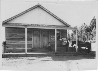
Pheasant Creek Post Office, Pheasant Creek Post Office and General Store
PhotographEarly photo of general store and post office at Pheasant Creek, includes store owner handing mail to man with horse, with other man sitting on stepphotograph taken c. 1937post office, store, pheasant creek -
 Kinglake Historical Society
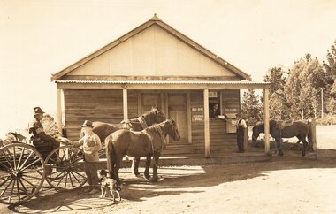
Pheasant Creek Post Office, Pheasant Creek General Store and Post Office, c.1935
... Kinglake West yarra-valley-and-the-dandenong-ranges Pheasant Creek ...Pheasant Creek General Store and Post OfficeEarly photograph showing store and post office with owner passing mail to man with horse, while a man on dray talks to man with a dog.Photograph of Pheasant Creek General Store and Post Office taken c.1935post office, store, pheasant creek -
 Cockatoo History & Heritage Group
photograph, Desmond, home of O'Hara family
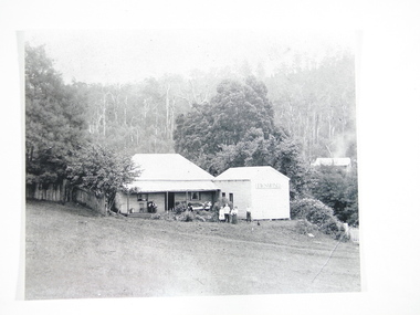
"Desmond", on the Cockatoo Creek, on land which now forms part of Alma Treloar Reserve, was the home of the O'Hara family ca. 1910. The poet John Bernard O'Hara, used to visit his mother there, and remembered many wonderful holidays with the "city folk" who travelled to Cockatoo on "Puffing Billy" and camped along the creek. The family in the foreground is most likely the O'Hara family.The photograph is significant because it shows a Cockatoo home of around 1910.Black and white photograph of "Desmond", home of the O'Hara family, with a family group in foreground. Situated on Cockatoo Creek, on land now known as Alma Treloar Reserve. Circa 1910.cockatoo homes, "desmond", o'hara family, cockatoo creek, john bernard o'hara. -
 Cockatoo History & Heritage Group
Postcard, Rose Stereograph Co, Fern Bower, Tourist Track, Cockatoo, VIC
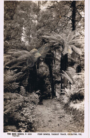
Cockatoo's Tourist Track featured in many postcards that were produced. It was an important attraction for the many holiday makers that came to Cockatoo in the early part of last century.The Tourist Track extended along the Cockatoo Creek, crossing the creek in various parts. It seemingly followed the creek until it ended in the vicinity of Mountain Rd and started near the swimming pool.Original Postcard - The Rose Series P 1619 cockatoo creek, tourist track, rose series postcard, cockatoo victoria -
 Cockatoo History & Heritage Group
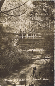
Postcard, Barratt Photo of Men on McBride St Bridge Cockatoo
An early Barratt photo of the Cockatoo Creek, looking towards the McBride St bridge. The four men depicted in the image, look relaxed and are taking in the serenity of the creek below.Dear Florrie, just a card to let you know I haven't quite ? altogether am up here among the ferns and ? It is a lovely place for a quiet holiday the fern gullys are just lovely you can see the Ranges in the distance as blue as the sea. This view is the bridge over Cockatoo creek near the R. Station. As space is short I will close Best Love from ?Original Barratt Photo, of four men standing on the McBride St bridge over the Cockatoo CreekRear of the postcard includes handwritten correspondence in ink, to someone called Florriea. t barratt, postcard, cockatoo creek, cockatoo, views of cockatoo, -
 Cockatoo History & Heritage Group
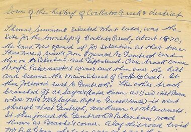
Letter, History of Cockatoo Creek and District by Myrtle Grayson
Myrtle Grayson (nee McKay) was the Grand Daughter of John and Sarah Orchard (two of Cockatoo's first settlers) and worked for James and Caroline McBride in 1911 at the age of 14Handwritten letter by Mrs Myrtle Grayson on foolscap paper. Letter written in 1984Blue pen on foolscap paperletter, history of cockatoo, myrtle grayson, cockatoo creek, -
Cockatoo History & Heritage Group
Recording, Dave Oliver recording on the history of Cockatoo 1995
After the devastating fires that hit Cockatoo on February 16th 1983. Dot Griffin recorded many of Cockatoo's earlier residents so their stories weren't lost like so much of Cockatoo's written history. Audio File, originally recorded on cassetterecording, cockatoo, cockatoo creek, audio file -
 Monbulk RSL Sub Branch
Book, Banner Books, Coomalie Charlie's commandos : 31 Squadron RAAF Beaufighters at Darwin 1942-43, 1996
A history of No31 Beaufighter Squadron at Coomalie CreekIndex, bib, ill, maps, p.140.non-fictionA history of No31 Beaufighter Squadron at Coomalie Creek world war 1939-1945 - aerial operations - australia, royal australian air force - 31 squadron - history -
 Monbulk RSL Sub Branch
Book, Allen & Unwin, Bomber boys, 2017
Bomber Boys is the extraordinary and little known story of more than 100 Dutch airmen stranded in Australia with no country to return to who were joined by a contingent of Australians to make up the RAAF's No. 18 (Netherlands East Indies Squadron). Formed in Canberra in April 1942, the squadron flew operational coastal patrols before eventually being relocated to the secret MacDonald Airfield, north of Pine Creek in the Northern Territory and then Batchelor near Darwin.Bib, ill, maps, p.305.non-fictionBomber Boys is the extraordinary and little known story of more than 100 Dutch airmen stranded in Australia with no country to return to who were joined by a contingent of Australians to make up the RAAF's No. 18 (Netherlands East Indies Squadron). Formed in Canberra in April 1942, the squadron flew operational coastal patrols before eventually being relocated to the secret MacDonald Airfield, north of Pine Creek in the Northern Territory and then Batchelor near Darwin.royal australian air force - 18th squadron, world war two 1939-1945 - aerial operations - australia