Showing 416 items
matching department of lands and survey
-
 Bendigo Historical Society Inc.
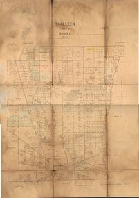
Map - JACK FLYNN COLLECTION: TOOLLEEN, 25/05.1926
... -Lithographed at the Department of Lands and Survey Melbourne. W. J...., Printer. Photo-Lithographed at the Department of Lands and Survey ...Map: Parish of Toolleen, County of Rodney. Parish plan.By Authority, H.J. Green. Govt., Printer. Photo-Lithographed at the Department of Lands and Survey Melbourne. W. J. Butson 25.5.26.map, rodney, parish plan, toolleen -
 University of Melbourne, Burnley Campus Archives
Plan, Plan of Richmond Park, 1872
... . Photo-lithographed at the Department of Lands and Survey, 6th..., Authorized Surveyor. Photo-lithographed at the Department of Lands ...Plan of Richmond Park L4461. Shows Horticultural Society's Garden without extra land used for Field Station (see 11.0363, but earlier). Surveyed and drawn by A.L. Martin, Authorized Surveyor. Photo-lithographed at the Department of Lands and Survey, 6th Sept. 1872.Handwritten notes on reverse and another railway line marked in pencil.railway lines, swan street, yarra river, richmond park, horticultural society, orchard -
Whitehorse Historical Society Inc.
Map, Melbourne and suburbs, 1923
... Department of Lands and Surve... at the Department of Lands and Survey, Melbourne by E. S. Hilcke, March 1923... Mitcham melbourne Department of Lands and Surve Melbourne ...Section of map 'Melbourne and Suburbs' compiled at the Department of Lands and Survey, Melbourne by E. S. Hilcke, March 1923, reprinted 1940.Section of map 'Melbourne and Suburbs' compiled at the Department of Lands and Survey, Melbourne by E. S. Hilcke, March 1923, reprinted 1940. Scale 40 chains: 1 inch. - Shire of Blackburn and MitchamSection of map 'Melbourne and Suburbs' compiled at the Department of Lands and Survey, Melbourne by E. S. Hilcke, March 1923, reprinted 1940.department of lands and surve, melbourne and suburbs -
Bendigo Historical Society Inc.
Map - WELLSFORD : COUNTY OF BENDIGO, 6-10-03
... at the Department of Lands and Survey Melbourne. 6-10-03. (number 21 in map.... Photo-Lithograph ed at the Department of Lands and Survey ...Map. Wellsford, County of Bendigo, Bagshot, Ellesmere, Axedale, Hunty, Sandhurst, Strathfieldsaye. Photo-Lithograph ed at the Department of Lands and Survey Melbourne. 6-10-03. (number 21 in map cupboard 1)T.E. McGearsonmap, bendigo, wellsford -
 Bendigo Historical Society Inc.
Map - Parish of Strathfieldsaye
... and Sedgewick. Photographed/Lithographed for the Department of Lands... and Sedgewick. Photographed/Lithographed for the Department of Lands ...Map owned by Henry Thomas (Jack) Qualtrough who worked for the Victorian Forestry Commission. Shire of Strathfieldsaye County of Bendigo canvas backed map. L5169. Includes Axedale, Kimbolton, Eppalock and Sedgewick. Photographed/Lithographed for the Department of Lands and Survey Melbourne by T E McGauran 24.3.07. Price 1/-.map, axedale, kimbolton, sedgewick, eppalock -
Bendigo Historical Society Inc.
Map - PANNOOMILLOO : COUNTY OF BENDIGO, 17-12-13
... , Warragamba, Milloo, Diggorra. Photo-Lithographed at the Department...-Lithographed at the Department of Lands and Survey, Melbourne by W.J ...Map. Pannoomilloo, County of Bendigo, Pannoobamawm, Warragamba, Milloo, Diggorra. Photo-Lithographed at the Department of Lands and Survey, Melbourne by W.J. Butson 17-12-13, Price 1/-. (number 82 in map cupboard 1)W.J. Butson.map, bendigo, pannoomilloo -
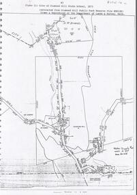 Bendigo Historical Society Inc.
Document - DIAMOND HILL STATE SCHOOL SITE
... Reserve File RS8128, drawn and reproduced at the Department... and reproduced at the Department of Lands and Survey, Melbourne' Document ...Map (copy) showing the site of Diamond Hill State School, 1873. On top of page 'extracted from Diamond Hill Public Park Reserve File RS8128, drawn and reproduced at the Department of Lands and Survey, Melbourne'bendigo, education, diamond hill state school -
Bendigo Historical Society Inc.
Map - PANNOOBAMAWM : COUNTY OF BENDIGO, 1957
... . Drawn and reproduced at the Department of Lands and Survey, 1957... and reproduced at the Department of Lands and Survey, 1957, Price 2 ...Map. Pannoobamawm, County of Bendigo, Terrick Terrick East, Wanurp, Pannoomilloo, Bamawm, Turrumberry, property allotments. Drawn and reproduced at the Department of Lands and Survey, 1957, Price 2/-. (number 410 in Map Cupboard 1 ).W.M. Houston, Government Printer, Melbourne.bendigo, hospital -
Bendigo Historical Society Inc.
Map - NERRING : COUNTY OF BENDIGO, August 1952
... at the Department of Lands and Survey, Melbourne, Victoria, August 1952..., Neilborough, Yarraberb. Drawn and Reproduced at the Department ...Map. Nerring, County of Bendigo, Leichardt, Marong, Sandhurst, Huntly, Neilborough, Yarraberb. Drawn and Reproduced at the Department of Lands and Survey, Melbourne, Victoria, August 1952, Price 2/-.( number 409 in Map Cupboard 1).J.J. Gourley, Government Printer, Melbourne.bendigo, hospital -
 Bendigo Historical Society Inc.
Map - CAMPBELL COLLECTION: BENDIGO AND DISTRICT MAPS, 1959
... and reproduced at the Department of Lands and Survey, Melbourne, 1958... and reproduced at the Department of Lands and Survey, Melbourne, 1958 ...Map. Huntly, County of Bendigo, Neilborough, Bagshot, Nerring, Wellsford, Sandhurst. Township of Huntly. By Authority A.C. Brooks, Government Printer Melbourne. Drawn and reproduced at the Department of Lands and Survey, Melbourne, 1958. Price 5/-.A.C. Brooks, Government Printermap, bendigo, allotments, huntly -
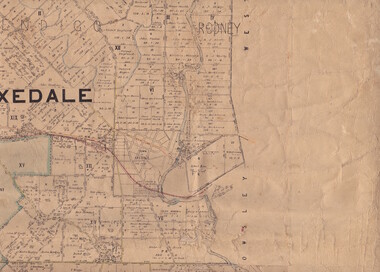
 Bendigo Historical Society Inc.
Map - JACK FLYNN COLLECTION: BURNEWANG, 17/09/1918
... Melbourne. Photo Lithographed at the Department of Lands and Survey... at the Department of Lands and Survey, Melbourne by W. J. Butson. Map ...Map: Parish of Burnewang, County of Rodney. Parish plan.By Authority, H. J. Green, Acting Government Printer Melbourne. Photo Lithographed at the Department of Lands and Survey, Melbourne by W. J. Butson.map, rodney, parish plan, burnewang, rodney -
Bendigo Historical Society Inc.
Map - BAMAWM : COUNTY OF BENDIGO, 19-8-24
... at the Department of Lands and Survey, Melbourne by W.J. Butson, 19-8-24...-Lithographed at the Department of Lands and Survey, Melbourne by W.J ...Map. Bamawm, County of Bendigo, Turrumberry, Pannoobamawm, Diggorra, Ballendella, Millewa. Photo-Lithographed at the Department of Lands and Survey, Melbourne by W.J. Butson, 19-8-24, Price 1/-. (number 50 in map cupboard 1)W.J. Butsonmap, bendigo, bamawm -
Whitehorse Historical Society Inc.
Document, Annual Report, 1968
... for the year ended 30 June 1968. Department of Crown Lands and Survey.... of Victoria for the year ended 30 June 1968. Department of Crown Lands ...Annual Report of the Place Names Committee of Victoria for the year ended 30 June 1968. Department of Crown Lands and Survey.Annual Report of the Place Names Committee of Victoria for the year ended 30 June 1968. Department of Crown Lands and Survey.Annual Report of the Place Names Committee of Victoria for the year ended 30 June 1968. Department of Crown Lands and Survey.crown lands, victorian government, victoria. place names committee -
Bendigo Historical Society Inc.
Map - NEILBOROUGH : COUNTY OF BENDIGO, 13-10-27
... at the Department of Lands and Survey, Melbourne by W.J. Butson 13-10-27..., Photo-Lithographed at the Department of Lands and Survey ...Map. Neilborough, County of Bendigo, Tandarra, Whirrakee, Huntly, Nerring, Yarraberb, Yallook, Photo-Lithographed at the Department of Lands and Survey, Melbourne by W.J. Butson 13-10-27, Price 1/- (number 77 in map cupboard 1)W.J. Butson.map, bendigo, neilborough -
Bendigo Historical Society Inc.
Map - MANDURANG : COUNTY OF BENDIGO, 1962
... Printer, Melbourne. Drawn and Reproduced at the Department.... Drawn and Reproduced at the Department of Lands and Survey ...Map. Mandurang, County of Bendigo. Sandhurst, Strathfieldsaye, Sedgwick, Lockwood. By authority A.C. Brooks, Government Printer, Melbourne. Drawn and Reproduced at the Department of Lands and Survey, Melbourne, 1962, Price 2/-. (number 67 in map cupboard 1)A.C. Brooks, Government Printer, Melbourne.map, bendigo, mandurang -
Bendigo Historical Society Inc.
Map - TALAMBE : COUNTY OF BENDIGO, 21-3-27
... at the Department of Lands and Survey, Melbourne, by W.J. Butson 21-3-27...-Lithographed at the Department of Lands and Survey, Melbourne, by W.J ...Map. Talambe, County of Bendigo, Hayanmi, Calivil, Pompapiel, Yallook, Tandarra, Dingee. Photo-Lithographed at the Department of Lands and Survey, Melbourne, by W.J. Butson 21-3-27, Price 2/-. (number 27 in map cupboard 1)W.J. Butsonmap, bendigo, talambe -
Bendigo Historical Society Inc.
Map - CAMPBELL COLLECTION: BENDIGO AND DISTRICT MAPS, 11-2-37
... chains to 1 inch. Drawn and reproduced at the Department of Lands... inch. Drawn and reproduced at the Department of Lands ...Map. Parish of Shelbourne, County of Bendigo. Scale 40 chains to 1 inch. Drawn and reproduced at the Department of Lands and Survey, Melbourne, Victoria. Price 2/-.11-2-37. By Authority H.J. Green, Government Printer, Melbourne.H.J. Green, Government Printermap, bendigo, agricultural lands -
Bendigo Historical Society Inc.
Map - EPPALOCK : COUNTY OF BENDIGO, 2-11-14
... at the Department of Lands and Survey, Melbourne by W.J. Butson, 2-11-14.... Photo-Lithographed at the Department of Lands and Survey ...Map. Eppalock, County of Bendigo,Lyell, Sedgwick, Strathfieldsaye, Axedale, Knowsley, Kimbolton. Photo-Lithographed at the Department of Lands and Survey, Melbourne by W.J. Butson, 2-11-14. Price 1/-. (number 39 in map cupboard 1)W.J. Butson.map, bendigo, eppalock -
Bendigo Historical Society Inc.
Map - YARRAYNE : COUNTY OF BENDIGO, 6-1-32
... at the Department of Lands and Survey, Melbourne. Price 2/-. 6-1-32... at the Department of Lands and Survey, Melbourne. Price 2/-. 6-1-32. (number ...Map. Yarrayne, County of Bendigo, Janiember East; Pompapiel, Salisbury, Bridgewater, Salisbury West, Powlett. Photo-Lithographed at the Department of Lands and Survey, Melbourne. Price 2/-. 6-1-32. (number 12 in map cupboard 1)H.J. Green, Government Printermap, bendigo, yarrayne -
Bendigo Historical Society Inc.
Map - PANNOOMILLOO : COUNTY OF BENDIGO, 1957
... , Diggorra, Pannoobamawm. Drawn and reproduced at the Department..., Pannoobamawm. Drawn and reproduced at the Department of Lands ...Map. Pannoomilloo, County of Bendigo, Milloo, Warragamba, Diggorra, Pannoobamawm. Drawn and reproduced at the Department of Lands and Survey, Melbourne,1957. Price 2/-. By Appointment W.M. Houston, Government Printer, Melbourne. (number 3 in map cupboard 1)W.M. Houston, Government Printermap, bendigo, pannoomilloo -
Bendigo Historical Society Inc.
Map - WANURP: COUNTY OF BENDIGO, 1/12/33
... at the Department of Lands and Survey, Melbourne, Price 2/-. 1/12/33..., Pannoobamawm. L422+. Photo-Lithographed at the Department of Lands ...Map. Wanurp, County of Bendigo, Terrick Terrick East, Mitiamo, Dingee, Milloo, Pannoobamawm. L422+. Photo-Lithographed at the Department of Lands and Survey, Melbourne, Price 2/-. 1/12/33 ( number 411 in Map Cupboard 1 )H.J. Green, Government Printerbendigo, hospital -
Bendigo Historical Society Inc.
Map - RAVENSWOOD : COUNTY OF BENDIGO, 28-7-14
... , Mandurang, Photo-Lithographed at the Department of Lands and Survey... at the Department of Lands and Survey by T.F. McGauran 28-7-14. (number 86 ...Map. Ravenswood, County of Bendigo, County of Talbot, Lockwood, Sutton Grange, Harcourt, Walmer, Bradford, Shelbourne, Mandurang, Photo-Lithographed at the Department of Lands and Survey by T.F. McGauran 28-7-14. (number 86 in map cupboard 1)T.F. McGauranmap, bendigo, ravenswood -
Bendigo Historical Society Inc.
Map - ROCHESTER WEST : COUNTY OF BENDIGO, 30-10-12
... at the Department of Lands and Survey, Melbourne, by W.J. Butson 30-10-12... of Rochester. Campaspe River. Photo-lithographed at the Department ...Map. Rochester West, County of Bendigo, Ballendella, Giggorra, Township of Rochester. Campaspe River. Photo-lithographed at the Department of Lands and Survey, Melbourne, by W.J. Butson 30-10-12. Price 1/-. (number 22 in map cupboard 1)W.J. Butson, Government Printer.map, bendigo, rochester west -
Bendigo Historical Society Inc.
Map - YALLOOK : COUNTY OF BENDIGO, 1957
... at the Department of Lands and Survey, Melbourne.1957. Price 2..., Salisbury, Pompapiel. Drawn and reproduced at the Department ...Map. Yallook, County of Bendigo,Talambe, Tandarra, Neilborough, Yarraberb, Salisbury, Pompapiel. Drawn and reproduced at the Department of Lands and Survey, Melbourne.1957. Price 2/-. By authority W.M. Houston, Government Printer. (number 11 in map cupboard 1)W.M Houston, Government Printermap, bendigo, yallook -
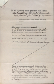 Federation University Historical Collection
Documents, Appointment of New Trustees of the Ballarat School of Mines and Industries, 1894, 1894
... department of lands and survey... of Department of Lands and Survey Letterhead... department of lands and survey letterhead legal john adrian louis ...A deed appointing the Reverend Samuel Thornton as a trustee of the Ballarat School of Mines, after the death of former Trustee Rivett Henry Bland, and increasing the number of trustees by appointing James Millhinch Bickett. It includes a covering letter of Department of Lands and Survey Letterhead... and whereas it is intended that forthwith after the execution hereof the said land and premises shall be so transferred that the same may become vested in the said Sir William John Clarke and John Warrington Rogers jointly with the said Right Reverend Samuel Thornton, Andrew Anderson and James Millhinch Bickett now these prexsents witness that the said Governor as such Governor as aforesaid in exercise of the power for this purpose given to him by the said Crown Grant and of every other power enabling him doth hereby appoint the Said Right Reverend Samuel Thornton to be a trustee of the land in place of the said Rivett Henry Bland and James Millhinch Bickett to the addition trustees. .. .department of lands and survey, letterhead, legal, john adrian louis earl of hopetoun, william john clarke, rivett henry bland, john warrington rogers, trustees, ballarat school of mines, ballarat school of mines trustees -
Bendigo Historical Society Inc.
Map - SALISBURY : COUNTY OF BENDIGO, 1965
... at the Department of Lands and Survey, Melbourne. Price $1.00. 1965..., Yarrayne, Bullock Creek. Drawn and reproduced at the Department ...Map. Salisbury, County of Bendigo, Pompapiel, Yallook, Yarraberb, Yarrayne, Bullock Creek. Drawn and reproduced at the Department of Lands and Survey, Melbourne. Price $1.00. 1965. By authority A.C. Brooks, Government Printer, Melbourne. (number 28 in map cupboard 1)A.C. Brooks,Government Printer, Melbourne.map, bendigo, salisbury -
Bendigo Historical Society Inc.
Map - WANURP : COUNTY OF BENDIGO, 1-12-33
... Printer.Photo-Lithographed at the Department of Lands and Survey... at the Department of Lands and Survey, Melbourne. Price 2/-. 1-12-33 ...Map. Wanurp, County of Bendigo, Terrick Terrick East, Mitiamo, Milloo, Pannoobamawm. By authority H.J. Green, Government Printer.Photo-Lithographed at the Department of Lands and Survey, Melbourne. Price 2/-. 1-12-33. (number 9 in map cupboard 1)H.J. Green, Government Printermap, bendigo, wanurp -
Bendigo Historical Society Inc.
Map - TALAMBE : COUNTY OF BENDIGO, January 1956
... , Melbourne. Drawn and reproduced at the Department of Lands... and reproduced at the Department of Lands and Survey, Melbourne. January ...Map. Talambe, County of Bendigo, Hayanmi, Pompapiel, Dingee, Tandarra, Yallook. By authority W.M. Houston, Government Printer, Melbourne. Drawn and reproduced at the Department of Lands and Survey, Melbourne. January 1956. Price 2/-. (number 8 in map cupboard 1)W.M. Houston, Government Printermap, bendigo, talambe -
Bendigo Historical Society Inc.
Map - SALISBURY : COUNTY OF BENDIGO, 1965
... , Government Printer, Melbourne. Drawn and reproduced at the Department..., Melbourne. Drawn and reproduced at the Department of Lands ...Map. Salisbury, County of Bendigo, Pompapiel, Yarrayne, Yarraberb, Yallook, Bullock Creek. By Authority: A.C. Brooks, Government Printer, Melbourne. Drawn and reproduced at the Department of Lands and Survey, Melbourne.1965. Price $1.00. (number 6 in map cupboard 1)A.C. Brooks, Government Printermap, bendigo, salisbury -
Bendigo Historical Society Inc.
Map - DERBY : COUNTY OF BENDIGO, 1959
... at the Department of Lands and Survey, Melbourne. 1959. Price 2/-. (number..., Government Printer, Melbourne. Drawn and reproduced at the Department ...Map. Derby, County of Bendigo, Bridgewater, Inglewood, Tarnagulla, Woodstock, Leichardt, Loddon River. By authority A.C. Brooks, Government Printer, Melbourne. Drawn and reproduced at the Department of Lands and Survey, Melbourne. 1959. Price 2/-. (number 54 in map cupboard 1)A.C. Brooks, Government Printer, Melbourne.map, bendigo, derby