Showing 314 items matching "developer"
-
 Vision Australia
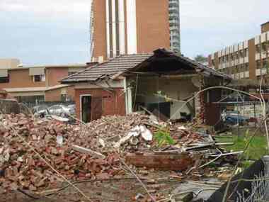
Photograph - Image, Demolition of Raleigh Street premises, 200
On September 23, 1925 the State Goverment gazetted a transfer of land in Raleigh Street, Prahran to RVIB. This was used to establish a hostel for women apprentices and workers, and building commenced in 1926 and was completed in 1927, at a cost of 3500 pounds. Demand for accommodation was strong and in 1929 a hostel for men was completed. The building were used as hostels for many years, but as demand decreased, the Institution found other ways to utilise the buildings. In 1972, a plant nursery was established on the site and other departments temporarily used the site. In 1994 the Employment Services team moved out of the building and the site was sold to developers.17 col. images of the partially demolished house at Raleigh Street, Prahranroyal victorian institute for the blind, raleigh street hostel -
 Falls Creek Historical Society
Document - Tourist Hotel Project
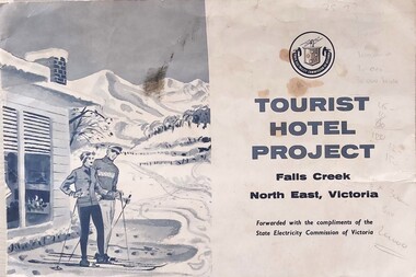
State Electricity Commission (SEC) outlined details of a site available for the development of a Tourist Hotel Project in Falls Creek in late 1962/3. SEC estimated that by the winter of 1963 Falls Creek Village would be able to accommodate 500 persons. The site for development was up to 2½ acres adjacent to the Upper Kiewa Valley Road. It envisaged a building able to accommodate about 100 guests. The successful developer would be granted a lease for 45 years at a rent of £300 per annum. Written applications for the lease were to be submitted by 31st March 1963.This item is significant because it documents plans made by the State Electricity Commission to develop the Falls Creek Tourist Area. A folder with a black and white image of skiers outside a hotel on the left. The logo of the State Electricity Commission and text is on the right half of the folder.On right half of cover: Logo of the State Electricity Commission TOURIST HOTEL PROJECT Falls Creek / North East Victoria Forwarded with the compliments of the State Electricity Commission of Victoriafalls creek tourist area, hotel development falls creek, falls creek projects 1963 -
 Port Melbourne Historical & Preservation Society
Programme, Roland Harvey, 1999 Port Melbourne Festival, Feb 1999
Produced by the Port Melbourne Festival Committee in conjunction with the Bay Street Traders and Circus Oz and distributed throughout the municipality. 1999 was the infamous street festival sponsored in part by the Gateway Project, a group of three developers intending to build tall buildings of up to 22 stories in Bay Street between Graham and Rouse Streets (see p. 11). This so angered the Port Phillip Council that they took the Festival from the Committee and put it out to tender from anyone that would restore its 'community' basis. Port Melbourne Neighbourhood House won the tender for 200 to 2002 (see items 1255)Program for Port Melbourne Festival 1999: A4, 16pp, full colour (two copies)arts and entertainment, celebrations fetes and exhibitions, town planning - proposals shelved, port melbourne festival committee, circus oz -
 Eltham District Historical Society Inc
Photograph, Guildo Fabbro, Falkiner Street, Eltham with Clydesdale horse
Guildo Fabbro, Falkiner Street, Eltham with Clydesdale horse with harness in field. The site of the Fabbro farm (Diamond Creek side land) is now called Barrack Bushlands. It is doubtful that Fabbro's farm holding was ever called Barrak Park, This title is fairly recent after the Shire of Eltham purchased the land, including the last section in 1993/94. About this time the area on the west side of Falkiner Street was purchased by a private developer and developed as housing. The area in Bell Street opposite the Eltham High School was purchased by the State Government is recent years and is called Fabbro Fields. The Fabbro Family operated their farm in Bell Street, Eltham. 1 black and white photographfabbro's farm, guido fabbro, bell street, clydesdale horse -
 Flagstaff Hill Maritime Museum and Village
Equipment - Balance Spring Scale, Peck, Stow & Wilcox, 1890-1910
Peck, Stow & Wilcox was founded in 1870 by the merger of three different industrial tool manufacturers specializing in tin-processing equipment. Their factory complex was at 217 Centre Street in Southington, Connecticut. The company grew rapidly, and was by 1890 producing a diversified array of tools. It was also the town's largest employer. The plant was substantially enlarged in 1912, which is the period when most of the buildings surviving in 1989 were built. By that time, the complex was operated by Ideal Forging. That company went bankrupt in 2003, and the plant was acquired by real estate developers not long afterwards. Demolition of the premises took place in 2015, after hazardous materials were removed from the site.A large American company that exported it’s goods all over the world and was a major producer of balance scales. The company no longer in existence and its products are now regarded as collectors items. The subject item in the Flagstaff Hill collection is significant as the pocket spring balance scale is one of the earliest produced.Spring Balance Scale Weighs 0 to 25LBS.Stamped PS&W. Has a five pointed star stamped on front.flagstaff hill, warrnambool, flagstaff-hill-maritime-museum, maritime-museum, shipwreck-coast, flagstaff-hill-maritime-village, spring balance scales, peck stow & wilcox, pocket balance scale, weighing scales -
 Bendigo Historical Society Inc.
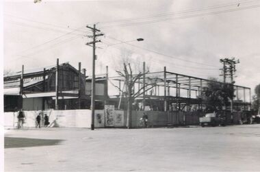
Photograph - S.E.C. VICTORIA, 1939
Photograph - black and white. The new SEC building still under construction. The 'old market building' can be seen to the left of the photo. Man on bicycle in dark clothing, man in black clothing walking to the right, lady in dark clothing walking to the left, light post with three cross bars and street light, advertising material displayed on corner section of fence, man in black standing over bhis bicycle to right of tree, dark colour utility vehicle parked in williamson street, twin power poles connected with 5 or six cross bars, vehicle angle parked in front of utility. Rear of photo has stamped name of the developer of the photo printed by Oliver's Bendigo. Number 79 witten in pencil.Printed by Olivers, Bendigo.organization, public utility, electricity company, s.e.c. victoria. 1939. bendigo. -
 Kew Historical Society Inc
Plan - Subdivision Plan, Old Kew Golf Links Estate - Third Section, 1920-1929
Pru Sanderson, in her groundbreaking ‘City of Kew Urban Conservation Study : Volume 2 - Development History’ (1988), summarised the periods of urban development and subdivisions of land in Kew. The periods that she identified included 1845-1880, 1880-1893, 1893-1921, 1921-1933, 1933-1943, and Post-War Development. These periods were selected as they represented periods of rapid growth or decline in urban development. An obvious starting point for Sanderson’s groupings involved population growth and the associated economic cycles. These cycles also highlighted urban expansion onto land that was predominantly rural, although in other cases it represented the decline and breakup of large estates. A number of the plans in the Kew Historical Society’s collection can also be found in other collections, such as those of the State Library of Victoria and the Boroondara Library Service. A number are however unique to the collection.The Kew Historical Society collection includes almost 100 subdivision plans pertaining to suburbs of the City of Melbourne. Most of these are of Kew, Kew East or Studley Park, although a smaller number are plans of Camberwell, Deepdene, Balwyn and Hawthorn. It is believed that the majority of the plans were gifted to the Society by persons connected with the real estate firm - J. R. Mathers and McMillan, 136 Cotham Road, Kew. The Plans in the collection are rarely in pristine form, being working plans on which the agent would write notes and record lots sold and the prices of these. The subdivision plans are historically significant examples of the growth of urban Melbourne from the beginning of the 20th Century up until the 1980s. A number of the plans are double-sided and often include a photograph on the reverse. A number of the latter are by noted photographers such as J.E. Barnes.When the old Kew Golf Links was subdivided in the mid 1920s, the developers were able to break the sale into sections. The third section included eighty lots. The lots faced Kilby Road, Kodak Avenue, Belford Road, Baker Avenue, Mathers Avenue, and White Avenue. [Kodak Avenue was renamed Page Avenue at a later date].The ‘Kew Conservation Study (1988) notes that ‘On the subdivision plan, Kodak’s involvement is commemorated by the naming of the streets after Company directors, and their decision to not proceed with the construction of the factory is explained as a response to the increase in the value of the land. This explanation may have been Estate Agent’s hyperbole, as the Kodak Company records suggest that the land, with its wide creek gully, was unsuitable and too small for its purposes.subdivision plans - kew, old kew golf links estate - third section -
 Ringwood and District Historical Society
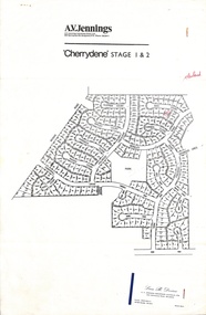
Flyer, Land Sale Advertisement - Cherrydene Estate, Stage 1 & 2, Ringwood, Vic. - 1969
Subdivison map of Cherrydene Estate and double-sided A4 size House & Land price list dated 27/10/1969. Developer - A.V. Jennings Industries (Aust) Ltd., Cnr. Springvale & Wellington Rds., Mulgrave, Vic. Phone 560 8411. Sales Dept. Rep., Leon B. Devine, Phone 560 8411 A/H.435 5311. Subdivision includes Wonga Road, Holyrood Crescent, Clipper Court, Ripley Court, Harwick Close, Bader Court, Towerhill Drive, Nigel Court, Berkley Road, Avis Court, Carmen Close, Frederic Drive, Kenwood Crescent, Adele Court, Marilyn Street, Abbey Court, Baron Court, Kismet Close, Oban Road, Ringwood.Furnished and landscaped display homes are open for your inspection, (see map on reverse side) from 11 a.m. to 5 p.m. Sundays and Holidays, and 2 p.m. to 5 p.m. weekdays and Saturdays. Display homes list for 'Cherrydene' Ringwood - Arundel, Ashmoor, Avalon, Cleveland, Chiltern, Dorset. -
 Eltham District Historical Society Inc
Photograph, Maurie Fabbro at age 20 at Fabbro's farm in Bell Street, Eltham, 1940, 1940
The site of the Fabbro farm (Diamond Creek side land) is now called Barrack Bushlands. It is doubtful that Fabbro's farm holding was ever called Barrak Park, This title is fairly recent after the Shire of Eltham purchased the land, including the last section in 1993/94. About this time the area on the west side of Falkiner Street was purchased by a private developer and developed as housing. The area in Bell Street opposite the Eltham High School was purchased by the State Government is recent years and is called Fabbro Fields. The Fabbro Family operated their farm in Bell Street, Eltham. Maurice Joseph Fabbro (Mario) was born 19 January 1920 and passed away 19 November 20091 black and white photographfabbro's farm, maurice fabbro -
 Warrnambool and District Historical Society Inc.
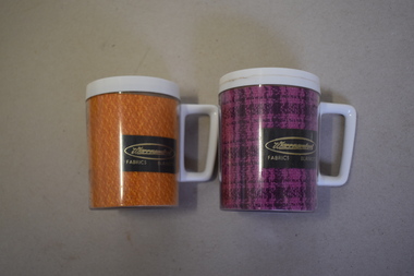
Mugs, Newlyne Mfg. Co Pty Ltd, Warrnambool Fabric Blankets, Mid 20th century
These mugs are souvenirs of the Warrnambool Woollen Mill. They were either sold as souvenirs or given to clients of the mill. The Warrnambool Woollen Mill in South Warrnambool was opened in 1910 with the first manager being John Bennett, an Englishman who recruited skilled weavers and bought mill equipment from his home country. At the height of production the mill was employing up to 700 people. In 1958 the mill became the first in Australia to manufacture electric blankets. In 1968 the mill was sold to the Dunlop company and in the ensuing years various companies owned the plant. In the year 2000 the mill was closed and the equipment was sold. The buildings were sold to a private developer and the first residents moved into the new housing estate in 2009. These mugs are of interest as mementoes of the Warrnambool Woollen Mill, a key industry in the development of Warrnambool and one that operated for 90 years. .1 This is an insulated plastic mug with a mottled orange-coloured body and a white rim on the top opening and a white handle. On the side of the mug is a printed name with gold lettering on a brown background. The maker’s name is etched into the base of the mug. .2 This is an insulated plastic mug with a purple and black mottled body and a white rim on the top opening and a white handle. On the side of the mug is a printed name on a brown background with gold lettering. The maker’s name is etched into the base of the mug. .1 & .2 Warrnambool Fabrics Blankets Steditemp Insulated Ware Made in Australia by Newlyne MFG Co Pty Ltd Division of J. Glaser & Co Melbourne warrnambool woollen mill -
 Eltham District Historical Society Inc
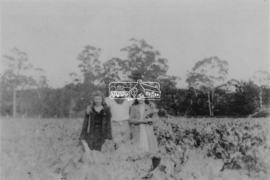
Photograph, From left: Unknown, Mario Fabbro and possibly Helen Skipper, Bell Street, Eltham
At Bell Street, Fabbro Farm, Eltham; From left: Unknown, Mario Fabbro and possibly Helen Skipper, standing in the middle of a vegetable crop. The site of the Fabbro farm (Diamond Creek side land) is now called Barrack Bushlands. It is doubtful that Fabbro's farm holding was ever called Barrak Park, This title is fairly recent after the Shire of Eltham purchased the land, including the last section in 1993/94. About this time the area on the west side of Falkiner Street was purchased by a private developer and developed as housing. The area in Bell Street opposite the Eltham High School was purchased by the State Government is recent years and is called Fabbro Fields. The Fabbro Family operated their farm in Bell Street, Eltham. 1 black and white photographfabbro's farm, bell street, eltham, maurice fabbro, farming, helen skipper, vegetables -
 Eltham District Historical Society Inc
Photograph, Fabbro's farm, Bell Street, Eltham, c.1990s
Fabbro's farm and house, Bell Street, Eltham, c.1990s. A crop of artichokes were planted on the farm at this time. The site of the Fabbro farm (Diamond Creek side land) is now called Barrack Bushlands. It is doubtful that Fabbro's farm holding was ever called Barrak Park, This title is fairly recent after the Shire of Eltham purchased the land, including the last section in 1993/94. About this time the area on the west side of Falkiner Street was purchased by a private developer and developed as housing. The area in Bell Street opposite the Eltham High School was purchased by the State Government is recent years and is called Fabbro Fields. The Fabbro Family operated their farm in Bell Street, Eltham. 1 colour photograph printed with white borderfabbro's farm, bell street, eltham, artichokes, barak farm -
 Eltham District Historical Society Inc
Photograph, Artichokes growing at Bell Street, Eltham, c.1990s
Fabbro's farm and house, Bell Street, Eltham, c.1990s. A crop of artichokes were planted on the farm at this time. The site of the Fabbro farm (Diamond Creek side land) is now called Barrack Bushlands. It is doubtful that Fabbro's farm holding was ever called Barrak Park, This title is fairly recent after the Shire of Eltham purchased the land, including the last section in 1993/94. About this time the area on the west side of Falkiner Street was purchased by a private developer and developed as housing. The area in Bell Street opposite the Eltham High School was purchased by the State Government is recent years and is called Fabbro Fields. The Fabbro Family operated their farm in Bell Street, Eltham. 1 colour photograph printed with white borderfabbro's farm, bell street, eltham, artichokes, barak farm -
 Eltham District Historical Society Inc
Photograph, Maurice Fabbro with artichokes growing at Bell Street, Eltham, c.1990s. Maurie is in his 70s
Fabbro's farm and house, Bell Street, Eltham, c.1990s. A crop of artichokes were planted on the farm at this time. The site of the Fabbro farm (Diamond Creek side land) is now called Barrack Bushlands. It is doubtful that Fabbro's farm holding was ever called Barrak Park, This title is fairly recent after the Shire of Eltham purchased the land, including the last section in 1993/94. About this time the area on the west side of Falkiner Street was purchased by a private developer and developed as housing. The area in Bell Street opposite the Eltham High School was purchased by the State Government is recent years and is called Fabbro Fields. The Fabbro Family operated their farm in Bell Street, Eltham. 1 colour photograph printed with white borderfabbro's farm, bell street, eltham, artichokes, barak farm, maurice fabbro -
 Vision Australia
Photograph - Image, St Kilda Road building in 2010, 6/1/2010
In 2007, Vision Australia sold it's iconic 557-563 St Kilda Road site. The historic bluestone building was in need of renovation and repair, had limited space for staff and clients and with more demand for services in suburban and regional areas, did not meet the needs of the national organisation. The purchaser was mainly interested in the Ormond Hall section, which they sub-divided off and sold to the tenant of the Belgian Beer Cafe. The remainder of the site was then sold on to another developer. Unable to quickly proceed with their plans on developing the site for residential buildings, the site fell into some disrepair in the interim which was when these images were taken. Later the site was sold again and residential buildings now occupy part of the block. 20 images taken of and from St Kilda Road buildingroyal victorian institute for the blind, buildings, myer house, ferguson and urie -
 Eltham District Historical Society Inc
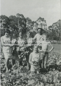
Photograph, At Bell Street, Eltham; from left: Helen Skipper, Matcham Skipper, Sonia Skipper and possibly Myra Skipper
At Bell Street, Fabbro Farm, Eltham; From left: Helen Skipper, Matcham Skipper, Sonia Skipper and possibly Myra Skipper, standing in the middle of a vegetable crop. The site of the Fabbro farm (Diamond Creek side land) is now called Barrack Bushlands. It is doubtful that Fabbro's farm holding was ever called Barrak Park, This title is fairly recent after the Shire of Eltham purchased the land, including the last section in 1993/94. About this time the area on the west side of Falkiner Street was purchased by a private developer and developed as housing. The area in Bell Street opposite the Eltham High School was purchased by the State Government is recent years and is called Fabbro Fields. The Fabbro Family operated their farm in Bell Street, Eltham. 1 black and white photographfabbro's farm, bell street, eltham, farming, helen skipper, vegetables, matchcam skipper, myra skipper, sonia skipper -
 Eltham District Historical Society Inc
Photograph, Antonio and Angelina Casonato and family
Antonio and Angelina Casonato with their four children and a baby cousin taken with lettuces growing on the river flat at Bell Street, Fabbro Farm (Fabbro Fields) in front of Eltham High School in the late 1960s. The site of the Fabbro farm (Diamond Creek side land) is now made up of Fabbro Fileds and Barrack Bushlands. This title is fairly recent after the Shire of Eltham purchased the land, including the last section in 1993/94. About this time the area on the west side of Falkiner Street was purchased by a private developer and developed as housing. The area in Bell Street opposite the Eltham High School was purchased by the State Government is recent years and is called Fabbro Fields. The Fabbro Family operated their farm in Bell Street, Eltham. 1 black and white photograph reproduction print (low quality)fabbro's farm, bell street, eltham, farming, vegetables, angelina casonato, antonio casonato, fabbro family, fabbro farm, fabbro fields -
 Federation University Historical Collection
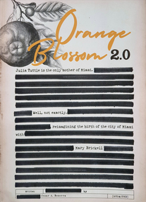
Book - History, Cesar A. Becerra, Orange Blossom 2.0, 2021
A historical book about Miami, centred around one of the primary city founders Mary Brickell. Author and historian Cesar BererraOrange title - Black orange image top left - Black & White Book, 235 pages, about Julia Tuttle the mother of Miami (Head image of Mary Brickell - Inside front and back cover - Orange images (front/back cover)non-fictionA historical book about Miami, centred around one of the primary city founders Mary Brickell. Author and historian Cesar Bererramary brickell, julia tuttle, miami, florida, city of brickell, william brickell -
 Eltham District Historical Society Inc
Photograph, H.J. Trowbridge, First kitchen at the first Post Office, Kinglake, c.1905, 1905
Reproduced 'Pioneers & Painters' p43 Source: Mrs. McMinn, Kinglake The photo is embossed in the lower left hand "H.J. Trowbridge," a photographer operating from at least 1895 and a photo stock dealer, developer and printer operating from Camera House in Collins St, Melbourne importing the finest English photographic equipment, paper, etc from 1905 through 1910 when he retired (Photo-focus. (1910, September 1). Punch (Melbourne, Vic. : 1900 - 1918; 1925), p. 3. Retrieved from http://nla.gov.au/nla.news-article175606285). He produced a 200 page catalogue in 1906 (H. J. TROWBRIDGE'S CATALOGUE. (1906, November 22). Punch (Melbourne, Vic. : 1900 - 1918; 1925), p. 3. Retrieved from http://nla.gov.au/nla.news-article175379934)This photo forms part of a collection of photographs gathered by the Shire of Eltham for their centenary project book,"Pioneers and Painters: 100 years of the Shire of Eltham" by Alan Marshall (1971). The collection of over 500 images is held in partnership between Eltham District Historical Society and Yarra Plenty Regional Library (Eltham Library) and is now formally known as 'The Shire of Eltham Pioneers Photograph Collection.' It is significant in being the first community sourced collection representing the places and people of the Shire's first one hundred years.Digital image of 4 x 5 inch B&W Negative Also 19 x 25 cm printPhotographers name H.J. Trowbridge Lwr LHsepp, shire of eltham pioneers photograph collection, kinglake, post office -
 Eltham District Historical Society Inc
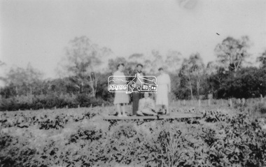
Photograph, At Bell Street; from left: Maurie Fabbro, Myra Skipper, Unknown, Arthur Munday, Ian Robertson. Helen Comprione in front
At Bell Street, Fabbro Farm, Eltham; from left: Maurie Fabbro, Myra Skipper, Unknown, Arthur Munday, Ian Robertson. Helen Comprione in front - probably helping to pick a crop. The site of the Fabbro farm (Diamond Creek side land) is now called Barrack Bushlands. It is doubtful that Fabbro's farm holding was ever called Barrak Park, This title is fairly recent after the Shire of Eltham purchased the land, including the last section in 1993/94. About this time the area on the west side of Falkiner Street was purchased by a private developer and developed as housing. The area in Bell Street opposite the Eltham High School was purchased by the State Government is recent years and is called Fabbro Fields. The Fabbro Family operated their farm in Bell Street, Eltham. 1 black and white photographfabbro's farm, guido fabbro, bell street, arhur munday, eltham, helen comprione, ian robertson, maurice fabbro, myra skipper, picking, farming -
City of Moorabbin Historical Society (Operating the Box Cottage Museum)
Document,leaflet 'Brief History of the City of Moorabbin 1850 - 1934', 2015
2015 CMHS members D. Maynard. Fran & Holger Bader compiled this Leaflet to provide a condensed information Leaflet about the origin and development of the area known as 'The City of Moorabbin' from 1850 -1994. Topics ; Aboriginal Bunurrung people, Henry Dendy's Special Survey 1841 in County of Bourke ; J.B Were, land agent, Pastoralists/ Squatters John O'Shannassy, Richard & John King, Moysey Family, Alexander MacDonald; Parish of Moorabbin Land Developers 1850 J.Holloway, A. Balcombe, D.Wickham, S. Charman, Keys Family; Road District of Moorabbin 1862 - 1870; Shire of Moorabbin 1871 - 1934; City of Moorabbin 1934 - 94; Amalgamation of Councils 1994 divided the City of Moorabbin between the Cities of Glen Eira, Bayside, Kingston and Monash; Origin of suburb names,This Leaflet was compiled in 2015 to provide a condensed history of the area known as 'The City of Moorabbin' for visitors , schools and local community1 x A4 printed both sides, black and white, folded x 3page 1 'BRIEF HISTORY OF THE CITY OF MOORABBIN' ; CITY OF MOORABBIN /1934-1994 page 2 'CITY OF MOORABBIN / 1934 - 94 city of moorabbin, county of bourke, moorabbin roads board, parish of moorabbin, shire of moorabbin, henry dendy's special survey 1841, were j.b.; bent thomas, o'shannassy john, king richard, charman s, highett william, ormond francis, maynard dennis, -
 Eltham District Historical Society Inc
Photograph, Maurice Fabbro and his mother Regina (wife of Guido) taken at home in Falkiner Street, Eltham
Maurice Fabbro and his mother Regina (wife of Guido) taken at home in Falkiner Street, Eltham. Regina passed away 21/03/1986 age 92 and is buried at Eltham Cemetery. (source: http://www.elthamcemetery.com/index.php/deceased-search) The site of the Fabbro farm (Diamond Creek side land) is now called Barrack Bushlands. It is doubtful that Fabbro's farm holding was ever called Barrak Park, This title is fairly recent after the Shire of Eltham purchased the land, including the last section in 1993/94. About this time the area on the west side of Falkiner Street was purchased by a private developer and developed as housing. The area in Bell Street opposite the Eltham High School was purchased by the State Government is recent years and is called Fabbro Fields. The Fabbro Family operated their farm in Bell Street, Eltham. Eltham, Falkiner Street, Maurice Fabbro, Regina Fabbro1 colour photographfabbro's farm, bell street, eltham, maurice fabbro, regina fabbro -
 Warrnambool and District Historical Society Inc.
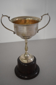
Trophy, ISCA Bates Cup Deck Quoits, 1930s
This trophy is one of several from the 1930s that were awarded as part of the competitions held in Warrnambool by the Inter-Church Indoor Sports Association. One of the sponsors of this competition was Fletcher Jones, the well-known clothing manufacturer who had his head office and main factory in Warrnambool. This trophy was the Bates Cup and it was probably donated by Harold Bates, a property developer who was a Warrnambool City Councillor from 1941 to 1945. This trophy was for the deck quoits competition. The game of quoits consists of competitors throwing four or five rings or hoops on to a raised spike some metres away. The hoops are generally made of plaited rope and the game is said to have been started or popularized by sailors on board ship. In deck quoits the raised spike is usually replaced by concentric circles drawn on the playing surface. This game became very popular on ocean liner cruise ships from the 1920s on. The winner of this trophy is not known.This cup is retained as a fine example of the trophies awarded for indoor sport in the 1930s in Warrnambool by the now-defunct inter church sporting associationThis is an electro plated nickel silver cup with two side handles and a thin stem on a silver base. The cup is mounted on a brown circular Bakelite stand. ‘I.C.I.S.A. Bates Cup Deck Quoits Championship’inter church sporting competitions warrnambool, warrnambool history -
 Federation University Art Collection
Photograph, Steinfort, Jessie, 'Mushrooms' by Jessie Steinfort, 1998
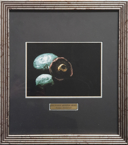
Jessie STEINFORT Steinfort was Studied Graphic Design at the University of Ballarat (later Federation University) After 12 years of working in design studios and advertising agencies, Steinfort is now a Senior Designer at Ogilvy Melbourne. And previously, he has been responsible for work on BMW & Mini, Carlton Football club, Melbourne Convention and Exhibition Centre, Melbourne Food & Wine Festival, AAMI, Yarra Valley Water, and Arts Centre Melbourne. From 2008 to 2011 Steinfort was lead designer and front-end web developer at clickDM (now HARDWIRE). Where he worked with such clients as HOSTPLUS, GSK, UniSuper and Swann Insurance. From 2000 to 2008 Steinfort was a designer at Mediation Communications working on print and interactive projects for; City of Melbourne, City of Greater Geelong, City of Port Phillip, Mentor Education, and ACMA. This item is part of the Federation University Art Collection. The Art Collection features over 2000 works and was listed as a 'Ballarat Treasure' in 2007. Framed photograph of three mushrooms in a black background. This work was won the 1998 Student Acquisition Award. If you can provide information on this artist or artwork please use the email link below. photography, foto, mushrooms, food, close up, macro, colour, photo, jessie steinfort, alumni, available -
 Kew Historical Society Inc
Plan, Studley Park Estate, 1910
Prue Sanderson, in her groundbreaking ‘City of Kew Urban Conservation Study : Volume 2 - Development History’ (1988), summarised the periods of urban development and subdivisions of land in Kew. The periods that she identified included 1845-1880, 1880-1893, 1893-1921, 1921-1933, 1933-1943, and Post-War Development. These periods were selected as they represented periods of rapid growth or decline in urban development. An obvious starting point for Sanderson’s groupings involved population growth and the associated economic cycles. These cycles also highlighted urban expansion onto land that was predominantly rural, although in other cases it represented the decline and breakup of large estates. A number of the plans in the Kew Historical Society’s collection can also be found in other collections, such as those of the State Library of Victoria and the Boroondara Library Service. A number are however unique to the collection.The Kew Historical Society collection includes almost 100 subdivision plans pertaining to suburbs of the City of Melbourne. Most of these are of Kew, Kew East or Studley Park, although a smaller number are plans of Camberwell, Deepdene, Balwyn and Hawthorn. It is believed that the majority of the plans were gifted to the Society by persons connected with the real estate firm - J. R. Mathers and McMillan, 136 Cotham Road, Kew. The Plans in the collection are rarely in pristine form, being working plans on which the agent would write notes and record lots sold and the prices of these. The subdivision plans are historically significant examples of the growth of urban Melbourne from the beginning of the 20th Century up until the 1980s. A number of the plans are double-sided and often include a photograph on the reverse. A number of the latter are by noted photographers such as J.E. Barnes.Coloured lithograph of a subdivision plan of the Studley Park Estate, bordered by Yarra, Willsmere Road and the Outer Circle Railway line. The estate was listed in 1910 and was the subject of a planning dispute between the developer and the Town of Kew in relation to flood levels and the suitability of the land for housing. In many cases the names of streets were subsequently changed. The layout was also affected by the creation of the Eastern Freeway. A newspaper report of the day described the subdivision as a: "GOLDEN OPPORTUNITY. We are pleased to submit for PRIVATE SALE that magnificent ESTATE, situated only 4 1/2 miles from the Melbourne General Post Office, STUDLEY PARK ESTATE. KF/NV. Doubtless the CHEAPEST LAND EVER OFFERED having extensive frontages to the prettiest spot on the River Yarra and the National Park, commanding lovely river and landscape views, and acknowledged to be the finest land available so close to the city. The PRICES ARE EXTREMELY MODERATE; The TERMS ARE SIMPLY MARVELLOUS. NO DEPOSIT. NO DEPOSIT. NO DEPOSIT. Allotments and prices to suit everyone."subdivision plans - kew, studley park estate -
 Melbourne Tram Museum
Newspaper, The Age, Progress Press, "Tram theme to stay at apartment complex", 2000
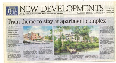
Set of 6 newspaper cuttings about the redevelopment of the site to apartments and the Hawthorn Tram Museum Depot. .1 - The Age - 8 Jan. 2000 - "Tram theme to stay at apartment complex" - announcing the redevelopment and plans for the redevelopment of Hawthorn tram depot. Includes architects impressions. Article by Victoria Gurvich. .2 -The Age - 14/1/2000 - letter to the Editor by Peter Moon - "Tram plan: too big and too ugly". .3 - Press - 21/2/2000 - "Trams on track for 498 years, Depot housing in line with history" - with photo of Mike Ryan and Matt Faubel (old photo) - article by Laeta Antonysen. .4 - ditto - "Outcry over historic site" and "Developers asked for another aspect" .5 - Progress Press - 6/3/2000 - letter re the redevelopment from John Santoro or Power St Hawthorn. .6 - Progress Press - 7/8/2000 - "Green light for tram depot apartments" - about the City of Boroondara issuing the planning permit.trams, tramways, hawthorn tram depot, tram museum, museums, minister for transport, city of boroondara -
 City of Moorabbin Historical Society (Operating the Box Cottage Museum)
Document,photocopy plan 'Two Acre Village 'c1852, c1960
In the 1852 Josiah Holloway, a developer, purchased 625 acres from the squatters Richard and John King and sectioned '2 acre allotments' south of Henry Dendy's Brighton Survey along the Arthur's Seat Road ( later Nepean Highway) for sale @ £10 It became known as The Two Acre Village as settlers took up the allotments and established market gardens, general stores, butchers, blacksmiths, post office and 2 hotels. Charles Whorral opened The Cheltenham Inn and it became so popular as a meeting place that the area was called Cheltenham. The early settlers, who were predominantly English and Scottish immigrants initially leased their allotments and, because the sandy soil was so fertile, they were soon able to purchase the land and increase their acreage. Cheltenham became a very important part of the large Moorabbin Shire1871 and City of Moorabbin 1934 In the 1994 Amalgamation of Councils, when the large City of Moorabbin was divided between the newly formed Glen Eira, Kingston and Bayside Councils, the Cheltenham area was assigned to the City of Kingston A photocopy of the Plan for the 2 Acre Village in Moorabbin Parish c1852. A3 laminatedmoorabbin, brighton, cheltenham, market gardeners, pioneers, early settlers, , king. john, holloway josiah, whorral charles, arthur’s seat road, nepean highway , cheltenham inn hotel, henry dendy special survey 1841 -
 Ballarat Heritage Services
Photograph - Digital photograph, Nose in Admiralty Arch, London, 19/09/2016
Admiralty Arch is a landmark building in London which incorporates an archway providing road and pedestrian access between The Mall, which extends to the southwest, and Trafalgar Square to the northeast. Admiralty Arch, commissioned by King Edward VII in memory of his mother, Queen Victoria and designed by Aston Webb is now a Grade I listed building. In the past, it served as residence of the First Sea Lord and was used by the Admiralty. Until 2011, the building housed government offices, but in 2012 the government sold a 125-year lease over the building to a property developer (Prime Investors Capital, run by Rafael Serrano) for redevelopment into a luxury hotel, restaurant and apartments. (Wikipedia) On the inside wall of the northernmost arch is a small protrusion the size and shape of a human nose. It was placed there by artist Rick Buckley in 1997 as part of a campaign against the "Big Brother" society. The nose is at a height of about seven feet, and sits at waist height for anyone riding through the arch on a horse. Prior to Buckley being unmasked in 2011 by the London Evening Standard, an urban myth grew that the nose is there in honour of the Duke of Wellington, who was known for having a particularly large nose.(wikipedia)admiralty arch, london, nose -
 Bendigo Historical Society Inc.
Mixed media - DONEY COLLECTION: DARKROOM EQUIPMENT
Alan Doney darkroom collection: 40a dartk room equipment collection 40b four film devreloping cannisters, adapts to adjustable film sizes (35mm, 120mm etc) 40c spool winder in two parts, stored in scotch tape tin 40d developer lens holder and fil/negative constraint for enlarging photos 40e darkroom light shade with electricity chord 40f red darkroom safety light for developing film with the darkroom 40g three developing items - two lens caps, thremometer caps/containers, & photo developing tongs 40h leather pouch for protection of flat ground glass panes 40i steel slide cover & bracket 40j two sets of steel film weights to hold/hang developed photograph films 40k rubber tubes and syphons 40l two plastic measuring beakers & two (yellow & blue) plastic spoons for developing process 40m KODAK film flow solution (Keogh's Camera Store $1.02) & KODAK plus-X pan film tin container 40n three darkroom miscellaneous items (includes Uniprint eqipment knob)