Showing 188 items
matching dirt road
-
 Kiewa Valley Historical Society
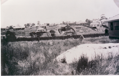
Photograph of Kiewa Valley Panorama, Farming lands within the Kiewa Valley in1950s, Circa 1950
... pockets of residentual houses can be viewed. Road access (unsealed... be viewed. Road access (unsealed dirt) was typical of that provided ...This photograph shows how (early to mid1900s), before the establishment of the Mount Beauty "gated" village, the Kiewa Valley was farmed and the scarce population was spread out over acres of productive land. This photograph catches a time before (what appeared to the local farmers as the invasion by a mass of construction workers) when this remote valley was part of a "lay back" rural landscape,occasionally visited by friends and some wayward tourists. The mountain ranges provided an adequate barrier against the way-would traveller. The immigration numbers coming into Australia was still quite small ( due to the "white" Australia policy) which was in force before World War II. After World War II a mass of displaced European refugees and migrants boosted the Australian population and provided for a greater degree of diverse professions and rural related work force.This photograph depicts the borderline in time between an exclusively rural based population and respective activities(early 1900s)to the present (2000 on wards) integrated village, tourist and retiree/holiday area. The time when land was exclusively used in agriculture is over and the impact of cheaper rural produce from Asian markets will see a shift of land useage and population activities. The Kiewa Valley is loosing its hiding place and is becoming more and more a source of untapped residential land. Black and white photograph of farming/grazing land useage, before the establishment of the Mount Beauty Village. Small pockets of residentual houses can be viewed. Road access (unsealed dirt) was typical of that provided in rural regions in the 1950s. The photo is on 200gms paper and not on photographic paper.kiewa valley in the early1900s, grazing in the kiewa valley, sec victoria -
 Kiewa Valley Historical Society
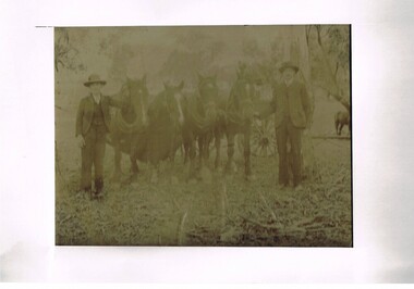
Photograph (Digital) Harnessing Horses, Harnessing Working Horses early 1900, early 1900s
... drawn carriages and transportation routes where dirt roads ...This copy of an original photograph created in the early 1900s details the "horse and cart" era when the normal transportation of the day was, in this rural setting, exclusively by horse and cart. The importance of this particular photograph to the subjects can be seen by the formal suits worn by both subjects.The natural bush and grassed backdrop have not been "touched up". The dray behind the horses is barely visible (fog like aperture). The lad , John Cooper was 14 years old when this photograph was taken. Both were in the process of harnessing four horses to "hook up" on the dray behind them. From their attire it looks like a trip to town or "the church".This photograph of life on a rural property in the early 1900 shows the rough and hard (physically) life in rural areas before great mechanical revolution/evolution post World War II. This was a time in the Kiewa Valley when most transportation was by horse drawn carriages and transportation routes where dirt roads with potholes. The significance of a local pioneer "family" encapsulated by this photograph cannot be reproduced as effectively in any other form. This digitised scanned copy of an original photograph of four work horses is on 200gms Fujicolor (Fujifilm) Crystal Archive paper has a silver side on which the image has been printed and a matt reverse side.The darker slightly "blurred" image has had a white frame placed over it at the time of encapsulation to provide the finished photo with a frame. This method highlights and focuses the view into the photograph. It is a clever way to permit the eyes to focus into the image to give it a greater third dimensional aspect. on the reverse side hand written(in pencil) "John Cooper & Paddy Cullen (itinerant worker) on grandfathers place (opposite Nesta Drews place) (orange Grove). "Grandfather emigrated from England with Ryders""orange grove " property, early tawonga life style, john cooper, paddy cullen, harnessing working horses -
 Kiewa Valley Historical Society
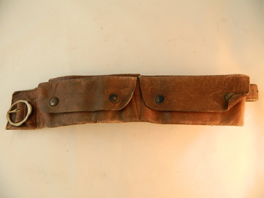
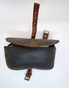
Belt Money, Circa 1950
This money, belt made of soft leather, would have been used in the mid 1900's by horse riding traders or wealthy property owners. It could also have been used by miners or other commercial business men. The main criteria for such a belt is security for valuables during travel on horseback. Commercial traders who plied their wares on horseback or caravans during a period where poor roads and flood prone rivers could dislodge wallets or money "sacks".The Kiewa Valley in the early 1900's was an environment which was frequented by the "canny" travelling salesman using dirt tracks and having to cross swollen rivers and creeks throughout the year. Travelling times within the rural areas in and surrounding the valley called for more frequent stops in bush lands. Camping presented itself with great challenges not to loose small cumbersome coin and notes. Local banks were of short supply and although bartering was a thriving method of transactions within the Valley traders from other regions were not so forth coming. Where ever possible local "trades" were called upon more than in city areas for limited products of a rural incline.This "vintage" handcrafted money belt has been professionally made circa 1950's. It appears as though it might have been made in a saddlery. There are five pockets each fastened by black painted "press studs". The stitching is of a high standard and the pockets are large and well defined. The buckle is circular with one fastening pin.handcrafts, leather work, vintage money belt, personal effects. -
 Kiewa Valley Historical Society
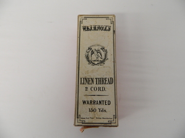
Box Linen Thread, early to mid 1900's
... affected by weather, long distance over dirt roads(poorly serviced ...This box which once contained linen thread manufactured in Scotland and labelled "British" manufacture" was used for the repair/manufacture of clothing by professional seamstresses and those wives required to "do" repair stitching of family clothes. This box was manufactured in a period when the title "United Kingdom" was used (late 1700's early 1900's) to describe the union of Britain and Scotland. The label however can be misleading as the"British Manufacture" thread was manufactured in Scotland. The broad term "British Manufacture" was used for the benefit of those in the "colonies" of Australia and New Zealand, during a period when the "coined" phrase "best of British, or British best" was synonymous to "top quality". After World War II the need for "cheaper products" was more persuasive than the quality of the product. In rural areas this shift to cheaper "non British" goods was at a slower rate than in the cities. Goods such as clothing manufactured or altered by seamstresses were regarded as of a higher standard and therefor the use of linen thread from "Britain" was a sign of quality and reliability.This box which contained linen thread, "British" made, is very significant to the Kiewa Valley because it demonstrates the conditions under which households in the late 1800's and early 1900's evolved from a "domestic repair /replacement" of damaged clothing to a consumer of recycled and shop bought clothing and linen. The ability of semi isolated rural based families to purchase "off the rack" clothing was severely affected by weather, long distance over dirt roads(poorly serviced) to large towns(shops), horse/cart or slower driven cars. The purchasing of clothing was, on the whole, from trading house "mail order" consignment orders.This red paper covered box has a white covered lid (top) with black print detailing the manufacturer and contents. This box contained 150 yds of linen thread 2 cord. A small added note pasted on one side "USUAL TWIST (s)" describing the thread's appearance. Two semicircular "finger" holes on two sides of the lid permit easier removal of the lid from the base.On the top lid: "W.&J. KNOX'S" below this a crest with latin motive "MOVEO ET PROFICIOR" English translation "I proceed and am more prosperous" encircling an open winged falcon. below this "LINEN THREAD", "2 CORD." "WARRANTED" "150 Yds." Made from Flax." British Manufacture". On one side "DRABS SOFT FINISH" within a shield "KNOX'S TWO CORD 150 YARDS 30" next to this a trade mark "W & J KNOX below this "made in KILBIRNIE, SCOTLAND"thread, cord. flax, box container, linen thread, seamstress items, cardboard box -
 Ringwood and District Historical Society
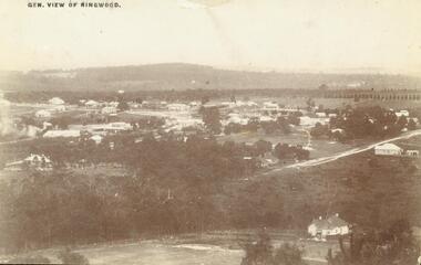
Photograph, View of Ringwood in 1912 taken from Loughnan's Hill
Black and white photograph looking across valley with small settlement. Mountains in background. (2 postcard copies and 2 enlargements). House in right foreground is in what is known now as Wildwood Grove. The dirt track above is Ringwood St. Field above is the football field with diagonal track coming out at Melbourne Street, later Eastland shopping complex. House on left is in Adelaide Street. Warrandyte Road is above it."Typed on back of one enlargement, "Copied from a postcard mailed in Ringwood, 1912, copied 1959. House in right foreground is in what is known now as Wildwood Grove. The dirt track above is Ringwood St. Field above is the present football field with diagonal track coming out at Melbourne Street. House on left is in Adelaide Street. Warrandyte Road is above it." House bottom RH side was still there in 1970 in Wildwood Grove (off Ringwood St). Ringwood Street lower centre to RH side. Field above Ringwood Street is the football field with diag. walk coming out at Melbourne Street. House on LH side in Adelaide Street. Warrandyte above it. Steam at LH from Bently's Steam Joinery at corner Main Street and Warrandyte Road. -
 Cheese World Museum
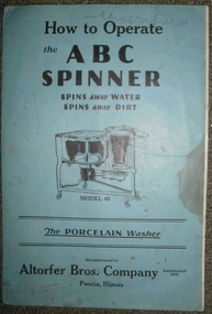
Manual, How to operate the ABC Spinner
Donated with the ABC Spinner washing machineBlue heavy paper cover with black lettering and an illustration of Model 60. Full title is 'How to operate the ABC Spinner -Spins Away Water -Spins Away Dirt. The Porcelain Washer -Manufactured by Altofer Bros Company Established 1909 Peoria Illinois Contents include parts price list and instructions for use'allansford, altofer brothers, abc spinner, washing machines, laundry aids -
 Marysville & District Historical Society
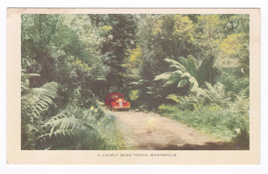
Postcard (item) - Colour postcard, Nucolorvue Productions, A Lovely Bush Track, Marysville, 1950's
... over impassable mud or dirt roads, yet rough in the best ...An early colour photograph of a car travelling along Lady Talbot Drive in Marysville in Victoria.An early colour photograph of a car traveling along Lady Talbot Drive in Marysville in Victoria. Lady Talbot Drive a 24 kilometer scenic rainforest car journey which passes a number of walks and waterfalls in the Yarra Ranges National Park. Lady Talbot Drive is named after Lady Sarah Elizabeth, the wife of Sir Reginald Talbot, who was the Governor of Victoria from 25th April, 1904 to 6th July 1908. This road was originally constructed as a corduroy road (or log road) is a type of road or timber trackway made by placing logs, perpendicular to the direction of the road over a low or swampy area. The result is an improvement over impassable mud or dirt roads, yet rough in the best of conditions and a hazard to horses due to shifting loose logs. This postcard was produced by Nucolorvue Productions in Elwood, Victoria as a souvenir of Marysville.POST CARD NUCOLORVUE PRODUCTIONS, ELWOOD, VICTORIAmarysville, victoria, nucolorvue productions, postcard, souvenir, lady talbot drive, lady talbot forest drive, sir reginald talbot, lady sarah elizabeth talbot, corduroy road -
 Marysville & District Historical Society
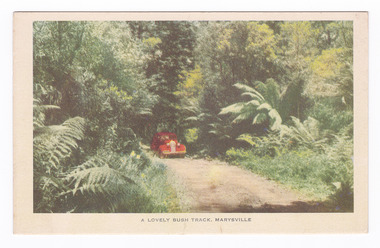
Postcard (item) - Colour postcard, Nucolorvue Productions, A Lovely Bush Track, Marysville, 1950's
... over impassable mud or dirt roads, yet rough in the best ...An early colour photograph of a car traveling along Lady Talbot Drive in Marysville in Victoria.An early colour photograph of a car traveling along Lady Talbot Drive in Marysville in Victoria. Lady Talbot Drive a 24 kilometer scenic rainforest car journey which passes a number of walks and waterfalls in the Yarra Ranges National Park. Lady Talbot Drive is named after Lady Sarah Elizabeth, the wife of Sir Reginald Talbot, who was the Governor of Victoria from 25th April, 1904 to 6th July 1908. This road was originally constructed as a corduroy road (or log road) is a type of road or timber trackway made by placing logs, perpendicular to the direction of the road over a low or swampy area. The result is an improvement over impassable mud or dirt roads, yet rough in the best of conditions and a hazard to horses due to shifting loose logs. This postcard was produced by Nucolorvue Productions in Elwood, Victoria as a souvenir of Marysville.POST CARD NUCOLORVUE PRODUCTIONS, ELWOOD, VICTORIAmarysville, victoria, nucolorvue productions, postcard, souvenir, lady talbot drive, lady talbot forest drive, sir reginald talbot, lady sarah elizabeth talbot, corduroy road -
 Marysville & District Historical Society
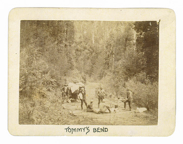
Photograph (Item) - Black and white photograph, Tommy's Bend, c1900
... over impassable mud or dirt roads, yet rough in the best ...An early black and white photograph taken at Tommy's Bend near Marysville in Victoria.An early black and white photograph taken at Tommy's Bend near Marysville in Victoria. Tommy's Bend is a stretch of road 10 kilometres from Marysville on the Woods Point Road up to Lake Mountain. This road was originally constructed as a corduroy road (or log road) is a type of road or timber trackway made by placing logs, perpendicular to the direction of the road over a low or swampy area. The result is an improvement over impassable mud or dirt roads, yet rough in the best of conditions and a hazard to horses due to shifting loose logs.ARMSTRONG COLLECTION 42 STATION STREET/ SANDRINGHAM 3191/ TEL. (03) 9521 5442/ IAN M.L. ARMSTRONG OAMtommy's bend, marysville, victoria, marysville-wood's point road, corduroy road -
 Marysville & District Historical Society
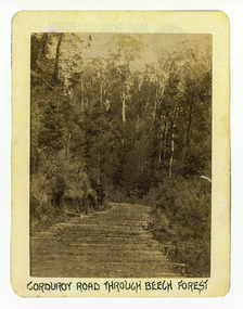
Photograph (Item) - Black and white photograph, Corduroy Road Through Beech Forest, c1900
... is an improvement over impassable mud or dirt roads, yet rough in the best ...An early black and white photograph of a corduroy road running through the forest near Marysville in Victoria.An early black and white photograph of a corduroy road running through the forest near Marysville in Victoria. A corduroy road (or log road) is a type of road or timber trackway made by placing logs, perpendicular to the direction of the road over a low or swampy area. The result is an improvement over impassable mud or dirt roads, yet rough in the best of conditions and a hazard to horses due to shifting loose logs.ARMSTRONG COLLECTION 42 STATION STREET/ SANDRINGHAM 3191/ TEL. (03) 9521 5442/ IAN M.L. ARMSTRONG OAMcorduroy road, marysville, victoria, beech forest -
 Marysville & District Historical Society
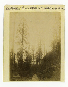
Photograph (Item) - Black and white photograph, Corduroy Road Beyond Cumberland Bridge, c1900
... is an improvement over impassable mud or dirt roads, yet rough in the best ...An early black and white photograph of a corduroy road running through the forest near Marysville in Victoria.An early black and white photograph of a corduroy road running through the forest near Marysville in Victoria. A corduroy road (or log road) is a type of road or timber trackway made by placing logs, perpendicular to the direction of the road over a low or swampy area. The result is an improvement over impassable mud or dirt roads, yet rough in the best of conditions and a hazard to horses due to shifting loose logs.ARMSTRONG COLLECTION 42 STATION STREET/ SANDRINGHAM 3191/ TEL. (03) 9521 5442/ IAN M.L. ARMSTRONG OAMcorduroy road, marysville, victoria -
 Flagstaff Hill Maritime Museum and Village
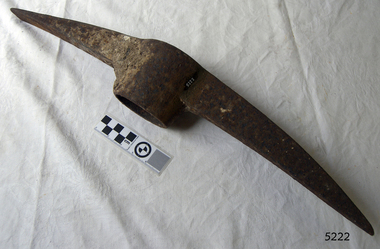
Pick Head
Railroad Pick, also called a Clay Pick or Dirt Pick. Point one end and chisel bit the other.flagstaff hill, warrnambool, shipwrecked-coast, flagstaff-hill, flagstaff-hill-maritime-museum, maritime-museum, shipwreck-coast, flagstaff-hill-maritime-village, railroad pick, clay pick, dirt pick -
 Glenelg Shire Council Cultural Collection
Photograph - Photograph - Dutton Way, 1976
... , Dutton Way. Ferguson's Road is a dirt track. Houses on right... Road, Dutton Way. Ferguson's Road is a dirt track. Houses ...Port of Portland Authority ArchivesBack: Dutton Way - pencil, lines leading to grey stamp. Location Date 30.6.76 - blue biro Time Reference 74/15 - blue biro -
Glenelg Shire Council Cultural Collection
Photograph - Photograph - Blacknose Quarry, n.d
Port of Portland Authority ArchivesBack: Purple PHT stampport of portland archives, blacknose quarry -
Glenelg Shire Council Cultural Collection
Photograph - Photograph - Harbour Construction, n.d
Port of Portland Authority Archivesport of portland archives, trawler wharf -
 City of Moorabbin Historical Society (Operating the Box Cottage Museum)
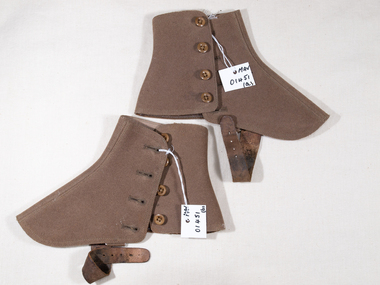
Footwear, Spats, wool, 20thC
Spats, a shortening of spatter guards are a type of classic footwear accessory for outdoor wear, covering the instep and the ankle. Spats are distinct from gaiters, which are garments worn over the lower trouser leg as well as the shoe. Since the mid-19th century, soldiers of various nations, especially infantry, often wore leggings or spats to protect their lower leg, to keep dirt, sand, and mud from entering their shoes, and to provide a measure of ankle support.These spats are of a type commonly worn to protect good shoes early 20thC and may have been part of a soldiers uniform c 1914A pair of khaki wool spats with 4 buttons and leather strap, with metal buckle, to pass under instep.MADE IN ENGLANDfootwear, spats, army uniform, clothing, knitting, craftwork, wool, world war 1 1914-18, world war 2 1939-1945, early settlers, city of moorabbin, bentleigh, mckinnon, ormond, moorabbin, post war settlers, hunt ailsa, -
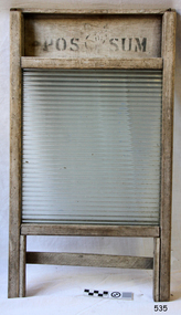 Flagstaff Hill Maritime Museum and Village
Domestic object - Washboard, 1900-1930
A washboard is a tool designed for hand washing clothing that are soaked in hot soapy water in a wash tub or sink, then squeezed and rubbed against the ridged surface of the washboard to force the cleaning fluid through the cloth to carry away dirt. With the invent of mechanized cleaning of clothing becoming more common by with the use of washing machines by the end of the 20th century the washboard was soon discontinued. The traditional washboard is usually constructed with a rectangular wooden frame in which are mounted a series of ridges or corrugations for the clothing to be rubbed upon. For 19th-century washboards, the ridges were often of wood, sometimes glass and by the 20th century, ridges of metal became common The first "fluted" metal washboard was patented in the United States by Stephen Rust in 1833 and Zinc washboards were predominantly manufactured in the United States from the middle of the 19th century. A significant item for cleaning clothes still in use today in many countries giving a snapshot into the domestic life of a housewife into the 20th century.Washboard wooden frame with a ribbed glass sectionMarked "Possum Brand"warrnambool, shipwrecked-coast, flagstaff-hill, flagstaff-hill-maritime-museum, shipwreck-coast, flagstaff-hill-maritime-village, washboard, glass ripples, clothes cleaning, washing, laundry -
 Coal Creek Community Park & Museum
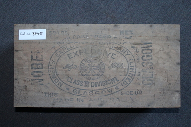
Box of explosives
8445.1 - Unhinged wooden box of explosives, quite covered in dust, made by "Nobel's explosives company (limited)"; lots of writing on the lid, and the two smaller sides, somewhat faded and occluded by dirt.- Nobel Glasgow - 50 lbs net - This side up - Made in Australia - With care - keep dry - Nobel's explosives company (limited) Glasgow - Explosive class III division I. - Alfa Nobel - Nobel's explosives company Limited - Trademark -
 Bendigo Historical Society Inc.
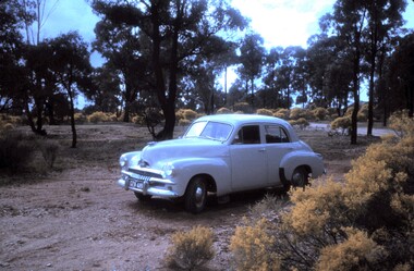
Slide - PETER ELLIS COLLECTION: SLIDE, May 1970 - Jan 1972
Coloured slide transparency. Image is of a car parked in a bush setting off a road. The car is a light coloured FJ Holden and is parked on dirt amongst low scrub and trees in the background. The words The car used to map the Whipstick are handwritten along the top border and the words The Whipstick Car Aug 31st 1974 are handwritten along the bottom border.Kodachrome Transparencyslide, bendigo, bendigo institute of technology -
 Sunshine and District Historical Society Incorporated
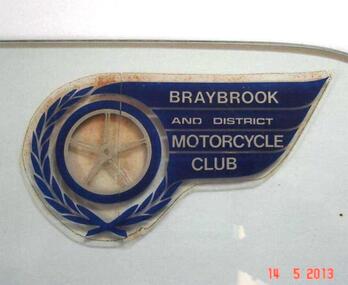
Club Sticker, BRAYBROOK & DISTRICT MOTORCYCLE CLUB
A meeting was held on 18th August 1947 at the East Sunshine Community Hall with the aim of forming a motor cycle club. The name BRAYBROOK MOTOR CYCLE CLUB was decided upon "as it would cater for riders and non-riding members in all surrounding districts". The first President was Don Minahan with Bert Watson as Secretary. They had been members of the Auto Cycle Union whose members became dissatisfied with the prize money awarded, so the Victorian Motorcycle Association (VMCA) was formed. The President of the VMCA (Mr. A. Clarke) attended the meeting on 3rd September 1947 which was held in the Hall behind the Sunshine Theatre. This became the regular meeting place. The new Braybrook Club affiliated with the VMCA joining clubs from Altona, Coburg, Essendon, Newport and Preston. Membership mostly came from recreational motor bike riders looking for more structured competitive riding experience and enjoyment. The club conducted its events on Sunday afternoons and as sport at that time was not permitted on Sundays, they overcame that obstacle by seeking a silver coin donation (pointing out that "two bob" was expected). The events were mainly dirt scrambles over open land which today is known as "off road". The favourite sites were Sunshine's ample open spaces such as Glengala Road and McIntyre Road, as well as Arundell Road (Keilor) and Laverton. For track racing experience the club formed a very basic dirt track on the open land in Glengala Road west of the original Sunshine Golf Club, which was very popular on Sunday afternoons for both riders and spectators. In the early 1950's Motorbike and Sidecar races were also witnessed on some Sundays, on a track near the corner of McIntyre and Furlong Roads, North Sunshine. During 1950 the Braybrook members voted in favour of allowing the Sunshine Club to amalgamate with them and form the BRAYBROOK AND DISTRICT MOTORCYCLE CLUB. The merger took place at the meeting on 10th July 1950 when office bearers were elected. The club disbanded in the mid 1960's due to the massive residential development occurring in the Sunshine district, and so activities were merged with the Newport Club. The above information is mainly compiled from Sunshine Advocate articles published on 29/8/47, 12/9/47, and 30/6/50, and from written details supplied by Mr. J. N. Willaton. Further details or corrections from interested readers are welcome.The Braybrook and District Motorcycle Club has not existed in its own right for several decades. The sticker depicting the club crest serves as a historical reminder that the club was once part of the local recreational scene.Dark blue, silver, and clear plastic sticker on right hand top corner of glass plate that previously was a side window of a car. Sticker has been left on the glass in case removal may damage it. BRAYBROOK AND DISTRICT MOTORCYCLE CLUB.Braybrook and District Motorcycle Clubmotorcycle club, sticker, club sticker, braybrook and district motorcycle club, braybrook -
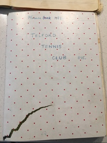 Yarrawonga and Mulwala Pioneer Museum
Telford Tennis Club minute books and records, 1920's to 2019
Telford Tennis courts were situated on the Telford Yarrawonga Road, west of the railway line, Telford station and silos. A thriving club existed from early 1920's with players from surrounding areas in early times. balls and tournaments were held as fundraisers. Prominent family names included Stevenson, Chappell, Mulquiney, Thom, Inchbold, Connell. Quinn. There were three teams during the 1960's playing in the Wilby and District Tennis Association ( WDTA) competition. Opponents included Wilby, Almonds, St Mary's, Bundalong, Savernake, Rennie, Roseneath, Burramine. Being in a low lying area the Telford dirt courts were often flooded. At the beginning of the season working bees were held to remove the weeds. mow the surrounds and line the courts During the early 1980's the courts were abandoned and home matches were played at the Yarrawonga Lawn Tennis courts. The club still has a team in the WDTA in 2019. A number of B grade Premierships have been won over the years however A grade premierships have been non existent. The club has always encouraged juniors to play and now the players mostly originate from Yarrawonga. Current President (2019) is Richard Inchbold, Secretary/Treasurer Joan Thom. The Bank account is held at the CMCU. The club is no longer IncorporatedCountry tennis teams provided a social outlet from the farming pursuits of the districtall enclosed in a cardboard box. Minute books 1927 to 2014 (not all complete). Includes photos, paper cuttings, Wilby and District Tennis Association draws, subs books, list of names of those who have played for Telford. Consumer Affairs returns, Incorporation papers, receipt books, some correspondence (later years)see photos -
 Whitehorse Historical Society Inc.
Photograph, 22 Pakenham Street, Blackburn, C.1950
Black and white photo of 22 Pakenham Street, Blackburn, looking West. Left hand corner is the dirt strip of Salisbury Avenue, Blackburn, heading up the hill to Middleborough Road. -
 Glen Eira City Council History and Heritage Collection
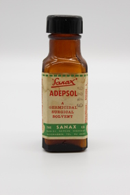
Adepsol Bottle
This Adepsol Bottle is part of a Sanax First Aid Case which was used at the the former Carnegie Senior Citizens' Centre. The centre was located at 314 Neerim Road, Carnegie. When the Neerim Road facility closed, its activities were moved to the Carnegie Library and Community Centre. For Occupational Health and Safety reasons, Council no longer maintains first aid kits at senior citizens' centres. Brown glass bottle with red, green and white paper label with Sanax branding, and usage directions. Black plastic screw-top lid. Bottle has been decanted however some white powder residue remains. "Sanax" ADEPSOL/ A GERMICIDAL / SURGICAL / SOLVENT / THE SANAX CO. / 849-51 NEPEAN HIGHWAY / MOORABIN / TEL XU 2651 / Directions: Dilute 1 in 4 with warm water for bathing Wounds, dab dry with absorbent cotton, then apply Germicide and dressing. For removing Germs, Grease, and Dirt from Wounds and Burns before finally dressing Wounds. -
 Surrey Hills Historical Society Collection
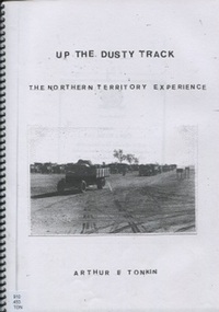
Personal memoir, Arthur Tonkin, Up the Dusty Track: The Northern Territory Experience
This is a personal account of Arthur Ernest Tonkin's experiences during World War 2. Arthur was a member of the 147 Australian General Transport Company. He enlisted in Alice Springs and spent the war as a driver along the route between Alice Springs and Darwin. There was no railway between Alice Springs and Darwin, and the road was more like a dirt track, but was essential for transportation of troops and supplies. Arthur was born in 1921 and spent most of his life in Surrey Hills.This is a compelling memoir written by a gentleman with a profound interest in history and an outstanding memory for detail, so although compiled when he was an advanced age, it is a significant memoir.illus.; 22p.; photos, A4 photocopied booklet spiral boundworld war, 1939-1945, darwin overland maintenance force, (mr) (lt col) noel medway loutit, central australian motor transport group, arthur ernest tonkin, memoir -
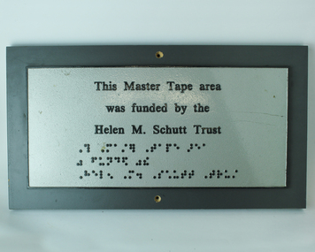 Vision Australia
Photograph - Image, Helen M Schutt trust plaque
Commemorative plaque for the funding of the Master Tape area by the Helen M. Schutt Trust. As an audio library, master tapes were created so that titles could be duplicated multiple times. Preserving these master tapes required a temperature controlled environment and minimal dust or dirt.Metal plate attached to wooden plaqueThis Master Tape area was funded by the Helen M. Schutt Trust (followed by brailled version of above)nameplates, royal victorian institute for the blind, association for the blind -
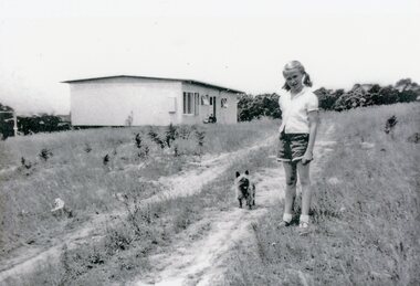 Park Orchards Community House
Photograph, 121 Arundel Road, Park Orchards property in summer 1958, Q4 1958
... Catherine O'Connor with "Tinker". The dirt track is Arundel...Park Orchards Community House 572 Park Road Park Orchards ...Catherine O'Connor with "Tinker". The dirt track is Arundel Road. The house is at (Lot 87) 121 Arundel Road, Park Orchards in Summer 1958. -
 Wodonga & District Historical Society Inc
Functional object - Bicycle Tool and Repair Kit, c1935
The first bicycles arrived in Australia in the 1860s. They gradually gained in popularity and by the 1890s they offered a cheap and relatively comfortable mode of transport. Far being just a means of leisure, long distance cycle travelling became a fact of life in rural areas for people such as sheep shearers and other agricultural labourers with migratory work. The bicycle and swag travelled much of Australia on dusty dirt tracks, long before the automobile was introduced. Today the bicycle continues to be an important item for general, cheap transport, sport and leisure. Tool kits such as those shown in the item, were and important piece of equipment for bicycle enthusiasts, particularly on a longer ride where assistance may not be close by if the rider experienced a punctured tyre. John Bull Rubber Co. Ltd. was a British tyre manufacturer based in Leicester. It was established in 1906 and was originally named Leicester Rubber Company. In 1915, a new factory was built in Evington Valley Road as indicated on the repair outfit tin in this kit. It was renamed John Bull Rubber in 1934 after its popular product of the same name. In 1958, the company was acquired by Dunlop Rubber. A leather bag containing tools and 2 tins containing rubber patches to repair bicycle tyres. The bag has 2 straps and metal buckles to attach it to the back of the bicycle seat.On tin 1: "The John Bull / Repair Outfit/ John Bull Rubber Co. Ltd./ Evington Valley Mills, Leicester" On tin 2: "ZENITH Repair Outfit / For Cycle and Rubber Repairs/ Self Vulcanizing" On tin 3: Around the DUNLOP logo "Six Self Lighting/ Patch Heat Units / For Cycle Tube/ Vulcaniser"bicycle history, bicycle repairs, john bull rubber, cycling leisure -
 Wodonga & District Historical Society Inc
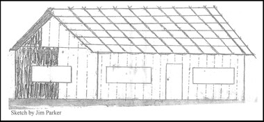
Drawing - The Green Hills School
Green Hills School was the first school in the Wodonga area. Before the school could open and a teacher commence duties, the Government had to be assured that a minimum of 20 children would be attending. The school was built of round timber, slab walls, bark roof, dirt floor and shuttered windows. The school opened in 1850 and closed in 1870. This sketch, completed by Jim Parker, a Life Member of Wodonga & District Historical Society, was included on a commemorative plaque as part of the Wodonga Heritage Drive established by the Society to recognise the story of key historic locations in the Wodonga area.This drawing is significant because it depicts the first school opened in Wodonga.A sketch of Green Hills School completed by Jim Parker, a life member of Wodonga & District Historical Society. This sketch was completed as part of a project to place commemorative plaques at key locations around Wodonga green hills school, wodonga schools, education wodonga -
 Greensborough Historical Society
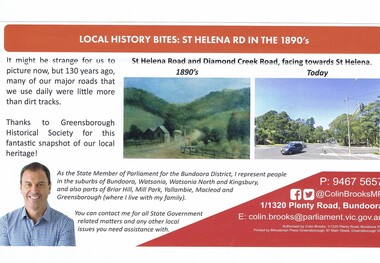
Article - Article Newsletter, Colin Brooks, Local history bites: St Helena Road in the 1890's, July 2024
... Article from Brooksy's Briefing about St Helena Road...Article from Brooksy's Briefing about St Helena Road ...Article from Brooksy's Briefing about St Helena Road as a dirt track in the 1890s compared to today.Newsletter article text with colour imagest helena, colin brooks, st helena road greensborough, greensborough historical society, diamond creek road greensborough -
 Eltham District Historical Society Inc
Photograph - Digital Photograph, Marguerite Marshall, Art Gallery at Clifton Pugh's Artists' Colony, Dunmoochin, Barreenong Road, Cottles Bridge, 5 February 2008
Art Gallery with mural painted by Clifton Pugh (1924-1990) at his Artists' Colony, Dunmoochin, Barreenong Road, Cottles Bridge. Following military service in the second world war, Clifton Pugh studied under artist Sir William Dargie at the National Gallery School in Melbourne as well as Justus Jorgensen, founder of Montsalvat. For a while he lived on the dole but also worked packing eggs for the Belot family saving sufficient to purchase six acres (2.4 ha) of land at Barreenong Road, Cottles Bridge. He accumulated more land and persuaded several other artists and friends to buy land nearby, resulting in a property of approximately 200 acres, stablishing it as one of the first artistic communes in Australia alongside Montsalvat in Eltham. It was around 1951 that Pugh felt he had '"done moochin' around" and so the name of the property evolved. He bought timber from Alistair Knox to build his house on the crest of a hill. Inspired by local goldminer's huts, it was a one room wattle-and-daub structure with dirt floor. Over the years it expanded with thick adobe walls made from local clay, high ceilings and stone floors. All materials other than the local earth were sourced from second hand materials, most found at wreckers' yards. Artists from across the nation were drawn to Dunmoochin, with several setting up houses and shacks on the property, maintaining their independence but sharing their artistic zeal. Artists who worked or resided at Dunmoochin included Mirka Mora, John Perceval, Albert Tucker, Fred Williams, Charles Blackman, Arthur Boyd and John Olsen. In 2002, Pugh's house along with its treasure trove of art and a library of some 20,000 books was destroyed by fire. Traces of Pugh's home remain with the presence of the Victorian doorframe archway with leadlight of intricate design, procured from a demolished Melbourne mansion; and two bronze life-sized female statues created by Pugh and cast by Matcham Skipper. In place of Pugh's house rose two double-storey mud-brick artists' studios topped with corrugated iron rooves curved like the wings of a bird with accommodation for seven. The original studios, gallery and other buildings survived the fire. Covered under Heritage Overlay, Nillumbik Planning Scheme. Published: Nillumbik Now and Then / Marguerite Marshall 2008; photographs Alan King with Marguerite Marshall.; p153 It’s not surprising that artist Clifton Pugh was drawn to Cottles Bridge to establish his artists’ colony Dunmoochin. Undisturbed by the clamour of modern life at Barreenong Road, Pugh was surrounded by the Australian bush he loved, and where his ashes were later scattered. The 200 acres (81ha) of bushland, broken by glimpses of rolling hills, has more than 50 species of orchids and Pugh shared his property with native animals including kangaroos, emus, phascogales, wombats, and diverse bird life. Pugh encouraged these creatures to join him in the bush by creating, with Monash University, a holding station where the animals were raised. Dunmoochin inspired Pugh for such paintings as in a book on orchids and the Death of a Wombat series.1 But his love for the bush was accompanied by the fear that Europeans were destroying it and much of his painting illustrated this fear and his plea for its conservation.2 However it was his house rather than the surrounding bush that was to be destroyed. Tragically in 2002 Pugh’s house, with its treasure of art and library of 20,000 art books, was destroyed by fire. Traces of the beauty of Pugh’s home still remain, however, in the magnificent Victorian doorframe archway with leadlight of intricate design procured from a demolished Melbourne mansion; and two bronze life-sized female statues created by Pugh and cast by Matcham Skipper. Now in place of Pugh’s house, are two double-storey mud-brick artists’ studios topped with corrugated roofs curved like birds’ wings, with accommodation for seven. The original studios, gallery and other buildings remain.3 Pugh grew up on his parents’ hobby farm at Briar Hill and attended the Briar Hill Primary School, then Eltham High School and later Ivanhoe Grammar. At 15 he became a copy boy for the Radio Times newspaper, then worked as a junior in a drafting office. Pugh was to have three wives and two sons. After serving in World War Two in New Guinea and Japan, Pugh studied under artist Sir William Dargie, at the National Gallery School in Melbourne.4 Another of his teachers was Justus Jörgensen, founder of Montsalvat the Eltham Artists’ Colony. Pugh lived on the dole for a while and paid for his first six acres (2.4ha) at Barreenong Road by working as an egg packer for the Belot family. Pugh accumulated more land and persuaded several other artists and friends to buy land nearby, resulting in the 200 acre property. They, too, purchased their land from the Belot family by working with their chickens. Around 1951 Pugh felt he had ‘Done moochin’ around’ and so the name of his property was born. Pugh bought some used timber from architect Alistair Knox to build his house on the crest of a hill. Inspired by local goldminers’ huts it was a one-room wattle-and-daub structure with a dirt floor. It was so small that the only room he could find for his telephone was on the fork of a tree nearby.5 Over the years the mud-brick house grew to 120 squares in the style now synonymous with Eltham. It had thick adobe walls (sun-dried bricks) made from local clay, high ceilings and stone floors with the entire structure made of second-hand materials – most found at wreckers’ yards. Pugh’s first major show in Melbourne in 1957, established him as a distinctive new painter, breaking away from the European tradition ‘yet not closely allied to any particular school of Australian painting’.6 Pugh became internationally known and was awarded the Order of Australia. He won the Archibald Prize for portraiture three times, although he preferred painting the bush and native animals. In 1990 not long before he died, Pugh was named the Australian War Memorial’s official artist at the 75th anniversary of the landing at Gallipoli. Today one of Pugh’s legacies is the Dunmoochin Foundation, which gives seven individual artists or couples and environmental researchers the chance to work in beautiful and peaceful surroundings, usually for a year. By November 2007, more than 80 people had taken part, and the first disabled artist had been chosen to reside in a new studio with disabled access.1 In 1989, not long before Pugh died in 1990 of a heart attack at age 65, he established the Foundation with La Trobe University and the Victorian Conservation Trust now the Trust for Nature. Pugh’s gift to the Australian people – of around 14 hectares of bushland and buildings and about 550 art works – is run by a voluntary board of directors, headed by one of his sons, Shane Pugh. La Trobe University in Victoria stores and curates the art collection and organises its exhibition around Australia.2 The Foundation aims to protect and foster the natural environment and to provide residences, studios and community art facilities at a minimal cost for artists and environmental researchers. They reside at the non-profit organisation for a year at minimal cost. The buildings, some decorated with murals painted by Pugh and including a gallery, were constructed by Pugh, family and friends, with recycled as well as new materials and mud-bricks. The Foundation is inspired by the tradition begun by the Dunmoochin Artists’ Cooperative which formed in the late 1950s as one of the first artistic communes in Australia. Members bought the land collaboratively and built the seven dwellings so that none could overlook another. But, in the late 1960s, the land was split into private land holdings, which ended the cooperative. Dunmoochin attracted visits from the famous artists of the day including guitarists John Williams and Segovia; singer and comedian Rolf Harris; comedian Barry Humphries; and artists Charles Blackman, Arthur Boyd and Mirka Mora. A potters’ community, started by Peter and Helen Laycock with Alma Shanahan, held monthly exhibitions in the 1960s, attracting local, interstate and international visitors – with up to 500 attending at a time.3 Most artists sold their properties and moved away. But two of the original artists remained into the new millennium as did relative newcomer Heja Chong who built on Pugh’s property (now owned by the Dunmoochin Foundation). In 1984 Chong brought the 1000-year-old Japanese Bizan pottery method to Dunmoochin. She helped build (with potters from all over Australia) the distinctive Bizan-style kiln, which fires pottery from eight to 14 days in pine timber, to produce the Bizan unglazed and simple subdued style. The kiln, which is rare in Australia, is very large with adjoining interconnected ovens of different sizes, providing different temperatures and firing conditions. Frank Werther, who befriended Pugh as a fellow student at the National Gallery Art School in Melbourne, built his house off Barreenong Road in 1954. Werther is a painter of the abstract and colourist style and taught art for about 30 years. Like so many in the post-war years in Eltham Shire, as it was called then, Werther built his home in stages using mud-brick and second-hand materials. The L-shaped house is single-storey but two-storey in parts with a corrugated-iron pitched roof. The waterhole used by the Werthers for their water supply is thought to be a former goldmining shaft.4 Alma Shanahan at Barreenong Road was the first to join Pugh around 1953. They also met at the National Gallery Art School and Shanahan at first visited each weekend to work, mainly making mud-bricks. She shared Pugh’s love for the bush, but when their love affair ended, she designed and built her own house a few hundred yards (metres) away. The mud-brick and timber residence, made in stages with local materials, is rectangular, single-storey with a corrugated-iron roof. As a potter, Shanahan did not originally qualify as an official Cooperative member.This collection of almost 130 photos about places and people within the Shire of Nillumbik, an urban and rural municipality in Melbourne's north, contributes to an understanding of the history of the Shire. Published in 2008 immediately prior to the Black Saturday bushfires of February 7, 2009, it documents sites that were impacted, and in some cases destroyed by the fires. It includes photographs taken especially for the publication, creating a unique time capsule representing the Shire in the early 21st century. It remains the most recent comprehenesive publication devoted to the Shire's history connecting local residents to the past. nillumbik now and then (marshall-king) collection, art gallery, clifton pugh, dunmoochin, cottlesbridge, cottles bridge, barreenong road