Showing 302 items matching "droving"
-
 Glen Eira Historical Society
Letter - MEMORIES GLEN EIRA ROAD
... Droving ...2 items: 1/A ten page handwritten letter from Mrs. C.R. Biesse on 12/12/1976 to Mr. Murray. The letter gives her memories of the area around Judge Hood’s Estate, related to her by an elderly acquaintance and her grandfather. Includes a small handdrawn map. 2/Handwritten research by Claire Barton on street names and residents off Orrong Road in 1911 Sands and McDougall directory.biesse c.r. mrs., merton street, caulfiled north, judge hood, hood crescent, droving, judge hood’s estate, land subdivision, judge stephens, st. mary’s church, otira road, helenslea road, shelford, landscapes, kerr b. mrs., palmer florence mrs., morrice street, glen eira road, kambea grove, bushland, cattle, mitchell mr. builder, palmer florence, mitchell colin, mitchell clive, mitchell francis, mitchell mrs., perry family, orrong road, st. aubins ave., ‘orotava’, hayes g.h., ‘kambea’, lothian henry, oswald j.d., ‘merton’, glen eira road -
 Eltham District Historical Society Inc
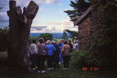
Photograph, Kangaroo Ground War Memorial, Eltham Heritage Tour, 24 May 1992, 24/05/1992
ELTHAM HERITAGE TOUR The Society excursion on 24th May 1992 was arranged by David Bick, leader of the team carrying out the Shire's heritage study. David selected a number of sites or buildings identified in the study, some of them lesser known components of the Shire's heritage. The tour commenced at the Eltham Shire Office at 10.00 am. Travel was by private car and mini-bus with stops at about twelve locations for commentary by David.It included a short walk in Hurstbridge and lunch at Kinglake. Highlights of the tour included: - 10 am Leave from Shire Offices - 3 Important Trees - A Physical Link to Eltham's First Settlers - Toorak Mansion Gates - A Surviving Farm House - An Intact Circa 1900 Main Street - First Settlers - Gold Miners, and Timber-getters - An Early Hotel - A Pioneering Homestead - Changing Eltham Shire - 20th Century - 4 pm Afternoon Tea and Finish Tour Extract from ELTHAM CULTURAL HERITAGE TOUR (Newsletter No. 85, July 1992, by Bettina Woodburn) "Now we drove through stands of pines to the Kangaroo Ground Lookout Tower, a most unusual War Memorial, World War I. The tower and a shed/residence (it had a chimney) were built from local sandstone. Below to the south and east of Melbourne spread 'suburbia'. Close by the landscape seemed so contrived - English fields and hedgerows! Although only about twenty inches deep, the soil of this ancient volcano, its crater lost under subsequent weathering, was rich, deserving the name of "Garden Hill". Now native trees are taking over again. In Kangaroo Ground itself stand the inevitable Store, School and Church - and two Norfolk pines and a monkey puzzle tree."Record of the Society's history and activities and highlighting various aspects of the Heritage Study undertaken by David Bick used to create the future heritage overlay for the Shire of Eltham and later Nillumbik Shire.Roll of 35mm colour negative film, 4 stripsKodak Gold 100 5095shire of eltham historical society, activities, heritage tour, kangaroo ground, kangaroo ground tower, war memorials, kangaroo ground memorial -
 Eltham District Historical Society Inc
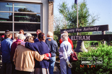
Photograph, Eltham Fire Station, Main Road, Eltham Heritage Tour, 24 May 1992, 24/05/1992
ELTHAM HERITAGE TOUR The Society excursion on 24th May 1992 was arranged by David Bick, leader of the team carrying out the Shire's heritage study. David selected a number of sites or buildings identified in the study, some of them lesser known components of the Shire's heritage. The tour commenced at the Eltham Shire Office at 10.00 am. Travel was by private car and mini-bus with stops at about twelve locations for commentary by David.It included a short walk in Hurstbridge and lunch at Kinglake. Highlights of the tour included: - 10 am Leave from Shire Offices - 3 Important Trees - A Physical Link to Eltham's First Settlers - Toorak Mansion Gates - A Surviving Farm House - An Intact Circa 1900 Main Street - First Settlers - Gold Miners, and Timber-getters - An Early Hotel - A Pioneering Homestead - Changing Eltham Shire - 20th Century - 4 pm Afternoon Tea and Finish Tour Extract from ELTHAM CULTURAL HERITAGE TOUR (Newsletter No. 85, July 1992, by Bettina Woodburn) "Commencing with a quick walk to see the magnificent bell at the Eltham Fire Station, we then 'drove along Arthur Street. Here were examples of what constitutes the building environment of Eltham. Massed among the wattles and eucalypts were golden cypress and pines; No. 50 was an exotic 'old English' manor-house; No. 93 had bluestone gateposts, from Fenton Road Toorak (as with Montsalvat, using re-cycled building material was very much the trend); past the natural Reserve dedicated to the artist Walter Withers, a plaque on a huge boulder; and on both sides houses in the various modes - timber with wrought iron decor, brick-some more recent than others, decades of 'suburbia'."Record of the Society's history and activities and highlighting various aspects of the Heritage Study undertaken by David Bick used to create the future heritage overlay for the Shire of Eltham and later Nillumbik Shire.Roll of 35mm colour negative film, 4 stripsKodak Gold 100 5095eltham, main road, shire of eltham historical society, activities, heritage tour, cfa -
 Eltham District Historical Society Inc
Photograph, Kangaroo Ground War Memorial, Eltham Heritage Tour, 24 May 1992, 24/05/1992
ELTHAM HERITAGE TOUR The Society excursion on 24th May 1992 was arranged by David Bick, leader of the team carrying out the Shire's heritage study. David selected a number of sites or buildings identified in the study, some of them lesser known components of the Shire's heritage. The tour commenced at the Eltham Shire Office at 10.00 am. Travel was by private car and mini-bus with stops at about twelve locations for commentary by David.It included a short walk in Hurstbridge and lunch at Kinglake. Highlights of the tour included: - 10 am Leave from Shire Offices - 3 Important Trees - A Physical Link to Eltham's First Settlers - Toorak Mansion Gates - A Surviving Farm House - An Intact Circa 1900 Main Street - First Settlers - Gold Miners, and Timber-getters - An Early Hotel - A Pioneering Homestead - Changing Eltham Shire - 20th Century - 4 pm Afternoon Tea and Finish Tour Extract from ELTHAM CULTURAL HERITAGE TOUR (Newsletter No. 85, July 1992, by Bettina Woodburn) "Now we drove through stands of pines to the Kangaroo Ground Lookout Tower, a most unusual War Memorial, World War I. The tower and a shed/residence (it had a chimney) were built from local sandstone. Below to the south and east of Melbourne spread 'suburbia'. Close by the landscape seemed so contrived - English fields and hedgerows! Although only about twenty inches deep, the soil of this ancient volcano, its crater lost under subsequent weathering, was rich, deserving the name of "Garden Hill". Now native trees are taking over again. In Kangaroo Ground itself stand the inevitable Store, School and Church - and two Norfolk pines and a monkey puzzle tree."Record of the Society's history and activities and highlighting various aspects of the Heritage Study undertaken by David Bick used to create the future heritage overlay for the Shire of Eltham and later Nillumbik Shire.Roll of 35mm colour negative film, 4 stripsKodak Gold 100 5095shire of eltham historical society, activities, heritage tour, kangaroo ground, kangaroo ground tower, war memorials, kangaroo ground memorial -
 Surrey Hills Historical Society Collection
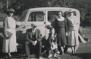
Photograph, David Miller and Lily Vipond Mair and family and friends on outing, c1932
David Miller (Dave) Mair (1879-1938) married Lily Vipond Deakin (1890-1945) in 1910. They had 5 children: Geoffrey David (1913-1970), Beryl (1916-1976), Gwynneth (1917-1997), Isabel Lillian (1921-1997) and Shirley Inez (1928-1968). Personal communication from Laurie Newton, Beryl's daughter: Dave and Lily initially lived in East Melbourne after they married. Dave walked across the gardens to work at the MCG. He never drove or owned a car. Geoffrey, Beryl and Gwynneth were born in East Melbourne. They subsequently moved to Louise Avenue, Mont Albert and Isabel may have been born while they were there. Later they purchased 20 Barton Street, Mont Albert. Shirley was born after they moved to Barton Street. Electoral roll details: 1919 68 Park Street, Hawthorn 1922 24 Louise Avenue, Mont Albert 1924 20 Barton Street, Mont Albert Dave Mair was a very keen sportsman. The woman named as Mattie was Martha Dunham Brooks b1892, Camberwell. She was the daughter of Arthur 'Empire' Brooks and his wife Mary Jane Wilson who lived at 21 York Street. They also had twin boys: Thomas Moffat Brooks – b. 1899, Surrey Hills; d. 1906 and Edwin Dunham Wilson Brooks – b. 1899, Surrey Hills; d. 1971 Heidelberg. The donor remembered the later as a builder of 11 York Street. Martha m. Clifford Ernest Cairns in 1935. Mattie Cairns was the donor's godmother. This is part of a large donation of material from the Deakin, Mair and Young families. This is part of a large donation of material from the Deakin, Mair and Young families all of which had connections with Surrey Hills / Mont Albert.A black & white photo of a man, a women, 2 women, a girl and a young lady beside a car in a country setting. The girl is bending to pat a dog.On rear: "Mum Dad Mair / Shirl Isabel Mattie / Digger - Cliff Cairns / Dog" in blue biro. Thought to be Beryl Mair's handwriting. "LILY" and "DAVE" in lead pencil above Mum and Dad. Photographer's stamp "653" in blue ink.dave mair, david miller mair, lilly vipond deakin, lily vipond mair, shirley inez mair, isabel lillian mair, mattie brooks, martha dunham brooks, cars -
 Surrey Hills Historical Society Collection
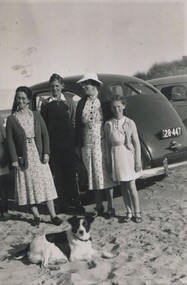
Photograph, Lily Vipond Mair with family and friends at the beach, c1936
David Miller (Dave) Mair (1879-1938) married Lily Vipond Deakin (1890-1945) in 1910. They had 5 children: Geoffrey David (1913-1970), Beryl (1916-1976), Gwynneth (1917-1997), Isabel Lillian (1921-1997) and Shirley Inez (1928-1968). Personal communication from Laurie Newton, Beryl's daughter: Dave and Beryl initially lived in East Melbourne after they married. Dave walked across the gardens to work at the MCG. He never drove or owned a car. Geoffrey, Beryl and Gwynneth were born in East Melbourne. They subsequently moved to Louise Avenue, Mont Albert and Isabel may have been born while they were there. Later they purchased 20 Barton Street, Mont Albert. Shirley was born after they moved to Barton Street. Electoral roll details: 1919 68 Park Street, Hawthorn 1922 24 Louise Avenue, Mont Albert 1924 20 Barton Street, Mont Albert Dave Mair was a very keen sportsman. The woman named as Mattie was Martha Dunham Brooks b1892, Camberwell. She was the daughter of Arthur 'Empire' Brooks and his wife Mary Jane Wilson who lived at 21 York Street. They also had twin boys: Thomas Moffat Brooks – b. 1899, Surrey Hills; d. 1906 and Edwin Dunham Wilson Brooks – b. 1899, Surrey Hills; d. 1971 Heidelberg. The donor remembered the later as a builder of 11 York Street. Martha m. Clifford Ernest Cairns in 1935. Mattie Cairns was the donor's godmother. This is part of a large donation of material from the Deakin, Mair and Young families. This is part of a large donation of material from the Deakin, Mair and Young families all of which had connections with Surrey Hills / Mont Albert. Mattie Brooks' father was a significant figure in early Surrey Hills.A black & white photo of 2 women, a girl and a lad beside a car on the sand at the beach.On rear: "Mum Mattie / Shirl / Digger (Cliff Cairns / Dog" in blue biro. "MATTIE BROOKS / LAD UNKNOWN" Thought to be Beryl Mair's handwriting. Photographer's stamp "653" in blue ink.beach, lily vipond mair, lilly vipond deakin, mattie brooks, martha dunham brooks, mattie cairns, martha dunham carins -
 Surrey Hills Historical Society Collection
Photograph, View from Goodwood Street, Surrey Hills in 1930, 1930
The Breeden family came to Surrey Hills in 1905, first to Guildford Road, then Middlesex Road where Horrie Breeden lived as a boy. He sometimes used to help with milking at the adjoining Kenneally's dairy in Highfield Road. Sometimes he and his brother drove the cows from there to Schneider's property near Florence Road on the way to Surrey Hills Primary School. The cows would graze here until the boys took them back after school. At other times he would deliver milk from the Croydon Road dairy (Isherwood's or Bovill's) to St Joseph's Boys Home before school. Horrie became an apprentice in woodwork / carpentry at Vine's timber yard before serving in World War 1. Horrie's father died in 1919 and in the same year he bought 3 cows and established his own dairy on his mother's property on the corner of Goodwood Street and Boisdale Road. In the 1920s Horrie built the first house in Goodwood Street. He went on to build others in the street including his own at No 7 Goodwood Street. He did all the joinery and internal fittings for this. [REF: Oral testimony: Horrie Breeden to Jocelyn Hall in 1979.] In the 1990s the owner of 7 Goodwood Street discovered a branding iron under the house; this is presumed to relate to Horrie Breeden's dairy. It was donated to SHNC's collection. Horrace Bruce Breeden (7 July 1898-24 January 1988) was son of Charles Henry Breeden and Lavinia Maria Darby, both born Warwickshire; buried in Box Hill Cemetery. He was one of a large family. He married Olive Mary Romey.Black and white photo taken from the east end of Goodwood Street, Surrey Hills in 1930, looking towards Elgar and Riversdale Roads. It shows an area which is rural in appearance. It is not built upon. The foreground is grassy and there is a post-and-wire fence to the right. There is a bank of eucalyptus trees behind which is hilly grassland.goodwood street, dairies, horace breeden, horrie breeden -
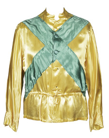 Victorian Harness Racing Heritage Collection at Lord's Raceway Bendigo
Clothing - Race colours, Don Dove
DON DOVE – 2016 Victorian Harness Racing Hall of Fame inductee A highly successful trainer-driver, Don Dove had something that most colleagues never had – his own sire. After making his mark early on as a driver, Don began training and driving the progeny of Dignus, a grand-son of Light Brigade he had purchased. Many of its 57 winners he trained and drove himself. The most memorable of these of course was his best-ever pacer, a 1966 colt he named Monara. It won successive A. G. Hunter Cups in 1973 and 74, and many other races – so often with this brilliant beginner going to the lead and then Don playing cat-and-mouse tactics out in front before dashing this son of Dignus away and holding off all comers. Those who may remember the 1972 Inter Dominion Final when Don was having a little holiday, will agree Monara was something beaten into second place that night. Don won many races on his brother Eric’s trotter Just Money, along with Nelson’s Report, Lauries Legacy and Kara Miss, and filled in well when winning the 1965 Warragul Cup driving the great little Macaree, and the 1967 Victoria Derby driving Kelly Kid. When the Victorian Trainers and Drivers Association formed in 1968, he was elected to its first committee. Don is also the father of Trevor and Stephen, both well known horsemen of a few seasons back. In retirement, Don Dove moved to Queensland in 1998 and it was there he passed away in 2014 at the age of 86.Yellow, with green crossed sashesdon dove, d dove, monara, amlin, bendigo harness racing club, bhrc, bendigo, horses, race colours, trotting, pacing, harness racing, dv dove -
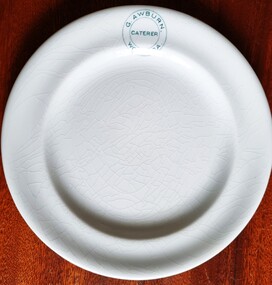 Wodonga & District Historical Society Inc
Functional object - G. Awburn Caterer Wodonga Plate
Mr George Awburn Jr. arrived in Wodonga West with his parents by bullock dray when he was aged six years old. As a young man he went to Melbourne where he worked with the Melbourne Tramway and Omnibus Company. He drove the first through tram from Abbotsford to Balaclava. On he return to Wodonga, Mr. Awburn opened a bakery and grocery business in Sydney St., Wodonga which he conducted up till the time of his death in 1946. He was active in community affairs in roles including being a foundation member of the Library Committee, a committeeman of the Town Band and football club, a member of the Hibernian Lodge and an ardent worker for the Roman Catholic Church. Johnson Bros. was founded by two brothers named Alfred and Frederick who purchased a pottery factory in Hanley, England, in 1883. They were grandsons of a renowned English potter, Alfred Meakin. They were later joined in the business by their brothers Henry and Robert. Their business grew rapidly, as they were one of the world's largest pottery factories by the turn of the 20th century. By 1970, Johnson Bros. obtained the Royal Charter to become the official provider of china for Her Majesty Queen Elizabeth II. More than 1,300 patterns have been created throughout Johnson Brothers' history. Due to their growing success, manufacturing plants were established overseas including the establishment of a tableware factory, Johnson Brothers Australia in 1957 in Croydon, Victoria operated through a company known as Sovereign Pottery Ltd. Due to rising competition, Johnson Brothers became part of the Wedgewood Group in 1968. In 2015, following the acquisition of Wedgewood by Finnish company Fiskars, the Johnson Brothers branding was discontinued. The trademark on this bowl was used by Johnson Brothers between 1913 and 1942.This item originates from a well-known and respected Wodonga business.A round china plate imprinted with business name of G. Awburn Wodonga and Johnson Brothers on the back of the plate.On front: G. Awburn Caterer Wodonga On back: Hotelware / Johnson Bros/ Englandawburn family, wodonga businesses -
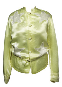 Victorian Harness Racing Heritage Collection at Lord's Raceway Bendigo
Clothing - Race Colours, Charlie Robertson
Charlie Robertson Jnr. Charlie Robertson, a Boort district farmer and trainer-driver, won his first race driving a horse called Black Spot in 1912 when he was 16. He drove many winners in the 1920s and 1930s, some of them trained by his father Charles Snr who had raced horses from the 1890s. He had a top trotter in Fair Admiral, who won the 1929 Victoria Trotters Derby among other races. As his career flourished, Charlie Jnr won with such horses as Lee Voyage, Royal Bronte, Johnnie Bronte, Betty Direct, Bonnie Heather and Leading Style. He was given the Globe Derby stallion New Derby to train by owner Jack King of Quambatook. He travelled to Tasmania and Western Australia with New Derby. In Tasmania in 1935, New Derby won the Hobart and Launceston Cups and in WA in 1936 won two heats of the inaugural Inter Dominion. Among New Derby’s wins were the 1932 and 1933 Ascot £500. He left 147 winners when standing at stud at Quambatook. During World War II one of the few venues for harness racing was Wayville in Adelaide. During this period Charlie made many trips across the border to race. On the commencement of night trotting, Robertson won many at the Royal Melbourne Showgrounds with Something New, Village Derby and Midnight News, New Gold, Canargo and Tennessee Derby. A bad race smash on Tennessee Derby nearly ended Charlie’s life, but he recovered. In the 1960s Charlie stood the stallion Convivial, who provided him with many winners. He retired from race driving aged 68 and died aged 87 after more than 60 years in trotting.Yellow with cream starscharlie robertson, c robertson, charlie robertson jnr, c robertson jnr -
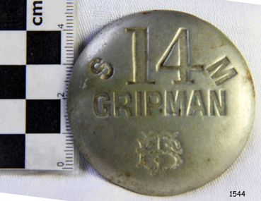 Flagstaff Hill Maritime Museum and Village
Badge - Gripman Badge, Stokes & Sons, Jul 1916 - Nov. 1919
This cable tram Gripman’s badge, or driver’s badge, was part of a tram driver’s uniform. The inscriptions on the front of the badge identify it as belonging to Gripman number 14, at the South Melbourne Car House depot of the Tramways Board. The Gripman Badge would be re-issued whenever another Gripman takes over the position. Cable trams were invented in America in 1873. In Melbourne, cable trams were in use from 1885 until 1940, with a network of up to 1200 cable cars or 'dummies' and trailers travelling at around 9.5 miles (15km) per hour along 46 miles (74km) of double tracks. The Gripman drove the dummy car, operating the heavy levers to connect the gripping gears to the cable installed in a slot in the road. To turn at intersections he would skilfully disconnect, freewheel around the corner and carefully reconnect to the continuously operating steel cable. Large winding gears in an Engine House along the line pulled the cable along, powered by steam engines and later electric engines. The gripping gears were in the centre of the car's floor with seating all around the sides, a dangerous place for curious children. , whose worried parents would guide them into the tram that was towed behind the dummy car. The Melbourne Tramways Board operated the cable trams between July 1916 and November 1919 after taking over from the privately operated Melbourne Tramway and Omnibus Company. In 1919, the Melbourne and Metropolitan Tramways Board (MMTB) took over the Tramways Board. Stokes & Sons: - The maker of the badge, Thomas Stokes, migrated to Melbourne from Birmingham in 1854 and set up business in Mincer Lane as a die-sinker, producing medals, tokens, buttons and silverware, and an engraving service. He moved to Flinders Lane in 1856. After a time, in 1894, the business became Stokes & Sons Pty: Ltd, electroplates and badge makers at Post Office Place in Melbourne. The maker's mark 'Stokes & Sons' was made on badges until 1962. LOCAL CONNECTION: -t was common practice to recycle the used cables from the tramway. For example, the Wollaston Bridge in Warrnambool, Victoria, is suspended by recycled cable tram Melbourne. (Other recycled cables were used for fencing wire.) -Portland's cable tram is an example of the cable trams used in Melbourne from 1885 to 1940.This badge was used to identify a Gripman who operated a cable car tram's dummy car for the Tramways Board in Melbourne between 1916 and 1919. It represents the need for people to be able to identify workers in the service industry, a need still addressed today by staff ID badges and digital identification. The badge also represents the period in Melbourne's history when cable cars were used for public transport for over four decades, gradually changing from steam to electric power. Trams still have an important role in Melbourne's public transport. Badge, round hollow metal dome with two open metal guides on the back. A cable tram Gripman (driver) badge with embossed inscriptions on the front and stamped on the back. There is a logo of entwined letters T and B on the front. It identifies Gripman number 14, South Melbourne, Tramway Board. It was made by Stokes & Sons of Melbourne. Impressed into the front: "S / 14 / M" "GRIPMAN" Logo intertwined "T" and "B" Embossed on reverse "STOKES &o SONS"flagstaff hill, flagstaff hill maritime museum and village, warrnambool, maritime museum, maritime village, great ocean road, shipwreck coast, badge, gripman, stokes & sons, numesmatics, tramway, tram, tram driver, uniform, cable tram, identification, cable car driver, tramway board, south melbourne, melbourne tramways board, tb, mtb, mmtb, melbourne and metropolitan tramways board, tramway button, gripman button, id, identification badg, staff badge, name badge, employee, grip car, dummy car -
 Bendigo Historical Society Inc.
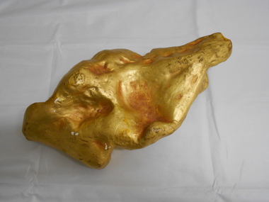
Memorabilia - GOLD NUGGET COLLECTION: THE PLATYPUS
A plaster replica of the 377 ozs gold nugget that was discovered in March 1861 in Robinson Crusoe valley at a depth of 5 feet by Mr John Knott and his son. It was the largest nugget found on the field. Value in 2016 $595,463. An article by the Bendigo Advertiser on Saturday 16 March 1861 describes the discovery "One of the largest pieces of gold that have been turned out of the ground on Bendigo, was yesterday brought to light in a small gully called Dead Bullock Gully, on the Kangaroo Flat side of Robinson Crusoe. The fortunate discoverers of the treasure are in this instance, as is generally the case, "fossickers," and where the nugget was found is in some old ground that has no doubt been turned over times innumerable within a few feet of the spot where the prize was lying hid. The exact weight of the nugget is 377 oz 6¾ dwts of as pure gold as ever came out of the ground. The finders are Mr John Knott and his son; the latter,a lad, being the party who actually found it, which he did under rather peculiar circumstances. He was down below in the old hole, putting a drive into an old pillar that had been left, when he drove his pick into the mass of gold, and partially discovered it. Under the excitement of the moment he cried out loudly, and his father, who was on top, immediately jumped down the hole, under the impression that his son had met with an accident, but fortunately found that he only required assistance in extracting the welcome stranger. The following is a description of the nugget. Length, twelve inches; width, six; while in some places it is of about two inches in thickness, in others it is only about half an inch. It has that peculiarity of form which from the days of the early finders of nuggets has enabled one to discover a resemblance to something either common or uncommon. We have had nuggets resembling frying pans, legs of mutton, dampers, and other articles in use in the rosy days of the diggings. In the present instance several parties who have seen the nugget assert that both in shape and size it is very much like an Australian Platypus, one of the ends of the nugget being exactly in formation like the snout of the animal. It will be exhibited today in the gold office of Mr Bannerman, and will, no doubt,attract the gaze of a crowd. Mr Knott states that at breakfast, before going to work in the morning, the boy mentioned to his mother that he had dreamt on the previous night that he would find a large nugget. May the similar dreams of every alluvial miner come as true as this realization of a prize worth between fourteen and fifteen hundred pounds in value."It has a sticker on it that says 'The Platypus 112'mining, models, plaster model of victorian gold nugget, https://trove.nla.gov.au/newspaper/article/87375584 -
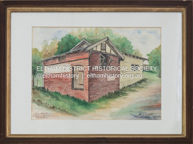 Eltham District Historical Society Inc
Painting, Audrey Cahn, Old Bakery, York Street, Eltham, May 1974
Painted for the Shire of Eltham Historical Society by Audrey Cahn, a member of our Society for many years and Vice President till 1978. Audrey was the sister of the late Charis Palling, founding president of our Society. She had remained a member for many years although she had moved from her family home at Warrandyte to live with her daughter in New South Wales. Audrey had been blind for some years but maintained a local interest by having our Newsletter read to her. Audrey's associations with Warrandyte started because her father Professor Osbourne had bought 60 acres in 1904. " Gold mining was beginning to die out and Warrandyte was a decaying area. Land was cheap because of the lack of transport and the soil was poor for farming” Audrey said. Audrey first attended school in the city at the Church of England Girls Grammar School and was always a bit rebellious. “If I felt some restrictions were unfair or some judgement unjust, I resented it”. Audrey got into Agricultural Science at Melbourne University and in 1928 was the second women to get such a degree. Audrey married in 1926, and later divorced Leslie Cahn an architect. They had twin daughters whom she left with her parents in Warrandyte while she studied dietetics during the depression. She found employment as a microbiologist at the Kraft/Walker Milk and Cheese Factory in Drouin - she drove home at weekends to see her daughters who were then at boarding school. During the war Audrey was in charge of catering at the Heidelberg Military Hospital – again the appointment of a women caused some unrest. She was in the army for more than 4 years and achieved the rank of General which-made her the most highly-ranked-woman at the hospital. After the war she became a senior lecturer in Dietetics at Melbourne University, again being aware of the limitations her gender brought to promotion possibilities. During her time at the university, she undertook a series of studies in nutritional biochemistry. Of especial note is the analysis of common dietary foods so that the composition and calorific value, the data that was needed for inclusion in Food tables - that professional sports people and weight-watchers so avidly follow today! She was an early proponent of the need to reduce fat intake and to substitute saturated fats with polyunsaturated fatty acids. In the 1950's Audrey and fellow workers established norms for the growth of Australian children to be compared with British and American children. Over 17 years they concluded that Australian children were overweight and inactive - what is new! She bought a cottage in Warrandyte as her home. In 1968 she retired to further develop her other interests as a potter and painter. Audrey was a foundation member of the group of potters that set up Potters Cottage. Audrey died in 2008 aged 102. (Ref:Newsletter No. 185 March 2009)art, artwork, audrey cahn, eltham, old bakery, york street -
 Eltham District Historical Society Inc
Photograph, Shire of Eltham War Memorial, Memorial Park, Garden Hill, Kangaroo Ground; Eltham Heritage Tour, 24 May 1992, 24/05/1992
ELTHAM HERITAGE TOUR The Society excursion on 24th May 1992 was arranged by David Bick, leader of the team carrying out the Shire's heritage study. David selected a number of sites or buildings identified in the study, some of them lesser known components of the Shire's heritage. The tour commenced at the Eltham Shire Office at 10.00 am. Travel was by private car and mini-bus with stops at about twelve locations for commentary by David.It included a short walk in Hurstbridge and lunch at Kinglake. Highlights of the tour included: - 10 am Leave from Shire Offices - 3 Important Trees - A Physical Link to Eltham's First Settlers - Toorak Mansion Gates - A Surviving Farm House - An Intact Circa 1900 Main Street - First Settlers - Gold Miners, and Timber-getters - An Early Hotel - A Pioneering Homestead - Changing Eltham Shire - 20th Century - 4 pm Afternoon Tea and Finish Tour Extract from ELTHAM CULTURAL HERITAGE TOUR (Newsletter No. 85, July 1992, by Bettina Woodburn) "Now we drove through stands of pines to the Kangaroo Ground Lookout Tower, a most unusual War Memorial, World War I. The tower and a shed/residence (it had a chimney) were built from local sandstone. Below to the south and east of Melbourne spread 'suburbia'. Close by the landscape seemed so contrived - English fields and hedgerows! Although only about twenty inches deep, the soil of this ancient volcano, its crater lost under subsequent weathering, was rich, deserving the name of "Garden Hill". Now native trees are taking over again. In Kangaroo Ground itself stand the inevitable Store, School and Church - and two Norfolk pines and a monkey puzzle tree." On November 11th 1926 the Shire of Eltham War Memorial Tower at Kangaroo Ground was opened. It is regarded as one of Melbourne’s most outstanding lookout towers. It commands a magnificent 360 degree panorama from Kinglake across the Diamond Valley to Macedon and the You Yangs. It is built on a peak which was once a volcano, 237 metres above sea level. After World War one a memorial cairn was erected on the site, and in 1925 a committee of public-minded citizens began to plan for a tower. Many generous donations of material and money were forthcoming so that in 1926 the Governor General Lord Stonehaven was able to unveil the plaque before a crowd of 500 people. There was some concern in the 1960s when the Forests Commission wanted to build a firespotters cabin on the top. At first R.S.L. branches opposed the idea, but it was realised that this use could combine with its use as a tourist attraction, and would ensure its maintenance for the future, Today the Kangaroo Ground tower provides one of the best views around Melbourne and is a fitting memorial to those who died in two world wars. From: Historic items for Diamond Valley Community Radio September 1990 (EDHS collection) Record of the Society's history and activities and highlighting various aspects of the Heritage Study undertaken by David Bick used to create the future heritage overlay for the Shire of Eltham and later Nillumbik Shire.Roll of 35mm colour negative film, 4 stripsKodak Gold 100 5095culture, events, garden hill, kangaroo ground, kangaroo ground memorial, memorial park, shire of eltham war memorial tower, war memorials -
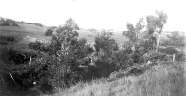
 Eltham District Historical Society Inc
Photograph, Murchison Gap, Autumn Excursion, Hume and Hovell's 1824 expedition, 26 May 1996, 26/05/1996
[article by Bettina Woodburn in EDHS Newsletter No. 109, July 1996:] ON THE TRAIL OF HUME AND HOVELL - REPORT ON THE AUTUMN EXCURSION - On a green and fresh morning (Sunday 26th May 1996) the Cobb and Co coach (driven by the most obliging Peter Tampion) set off in a north easterly direction from Eltham to connect with Hume and Hovell's route on their 1824 explorations of central Victoria. The Society would follow a series of monuments erected for the 1924 centenary of the expedition from King Parrot Creek (Tuesday 7th December 1824), through Strath Creek, over Sunday Creek (Sunday 12th December 1824) at Broadford, Tullamarine, St Albans, Deer Park, through Werribee, skirting east of the You Yangs to Lara and Avalon Beach. Because their distance-measuring wheel had broken and a one degree mistake was made in calculations, the two leaders of the original group of six convict-companions arrived at Corio Bay, instead of the expected Western Port, discovered earlier by Flinders. From below Mt. Disappointment (Hume and Hovell's difficulties in "scrambling over brush and rock", "leeches in forest, as well as no water", "cutting grass 4-5 ft. high", dreadful scrub", "devil flies") we took an easier route, saw the Strath Creek memorial in ground fog and a wonderful "field of dreams", the Hume-Hovell privately owned cricket ground with its white picket boundary fence. Now, after a steep climb, in sunshine under gums we stretched and viewed magnificent rolling hills and fog-filled valleys - not "smoke from Aborigines' bush fires". After morning tea at Broadford we followed the Sunday Creek valley beside the Hume Freeway, passed the Wallan Wallan Rest Area (more appropriately Hume and Hovell Rest Area) to tum right at Beveridge. In Gellibrand Hill Park, near the headwaters of the Moonee Ponds Creek, we experienced the landscape the first European settlers saw - huge river red gums and rolling pastures. The gardens and sheltered courtyard of the 1840s, timber, brought from .....[?] prefabricated Woodlands Homestead, provided a pleasant lunch stop. We enjoyed a private tour, panoramic views over Melbourne and surroundings and the excitement of arriving and departing aircraft. Our next river crossing was at Werribee, "in a vast treeless plain", then we drove on by-ways no coach had previously travelled, to find "an immense sheet of water" salty Corio Bay, off-course to the west. In late afternoon of a super, calm, late autumn day we headed homewards. Back at Eltham we were rather surprised to find that we had travelled a total of 347 km. Thanks again to Russell Yeoman for his research and organization. What a wonderful day! Three colour photographsactivities, murchison gap, murchison valley -
 Eltham District Historical Society Inc
Photograph, Hume and Hovell Monument, Broadford, Autumn Excursion, Hume and Hovell's 1824 expedition, 26 May 1996, 26/05/1996
[article by Bettina Woodburn in EDHS Newsletter No. 109, July 1996:] ON THE TRAIL OF HUME AND HOVELL - REPORT ON THE AUTUMN EXCURSION - On a green and fresh morning (Sunday 26th May 1996) the Cobb and Co coach (driven by the most obliging Peter Tampion) set off in a north easterly direction from Eltham to connect with Hume and Hovell's route on their 1824 explorations of central Victoria. The Society would follow a series of monuments erected for the 1924 centenary of the expedition from King Parrot Creek (Tuesday 7th December 1824), through Strath Creek, over Sunday Creek (Sunday 12th December 1824) at Broadford, Tullamarine, St Albans, Deer Park, through Werribee, skirting east of the You Yangs to Lara and Avalon Beach. Because their distance-measuring wheel had broken and a one degree mistake was made in calculations, the two leaders of the original group of six convict-companions arrived at Corio Bay, instead of the expected Western Port, discovered earlier by Flinders. From below Mt. Disappointment (Hume and Hovell's difficulties in "scrambling over brush and rock", "leeches in forest, as well as no water", "cutting grass 4-5 ft. high", dreadful scrub", "devil flies") we took an easier route, saw the Strath Creek memorial in ground fog and a wonderful "field of dreams", the Hume-Hovell privately owned cricket ground with its white picket boundary fence. Now, after a steep climb, in sunshine under gums we stretched and viewed magnificent rolling hills and fog-filled valleys - not "smoke from Aborigines' bush fires". After morning tea at Broadford we followed the Sunday Creek valley beside the Hume Freeway, passed the Wallan Wallan Rest Area (more appropriately Hume and Hovell Rest Area) to tum right at Beveridge. In Gellibrand Hill Park, near the headwaters of the Moonee Ponds Creek, we experienced the landscape the first European settlers saw - huge river red gums and rolling pastures. The gardens and sheltered courtyard of the 1840s, timber, brought from .....[?] prefabricated Woodlands Homestead, provided a pleasant lunch stop. We enjoyed a private tour, panoramic views over Melbourne and surroundings and the excitement of arriving and departing aircraft. Our next river crossing was at Werribee, "in a vast treeless plain", then we drove on by-ways no coach had previously travelled, to find "an immense sheet of water" salty Corio Bay, off-course to the west. In late afternoon of a super, calm, late autumn day we headed homewards. Back at Eltham we were rather surprised to find that we had travelled a total of 347 km. Thanks again to Russell Yeoman for his research and organization. What a wonderful day! Colour photographactivities, broadford, hume and hovell, monument -
 Eltham District Historical Society Inc
Photograph, Hume and Hovell Monument, Autumn Excursion, Hume and Hovell's 1824 expedition, 26 May 1996, 26/05/1996
[article by Bettina Woodburn in EDHS Newsletter No. 109, July 1996:] ON THE TRAIL OF HUME AND HOVELL - REPORT ON THE AUTUMN EXCURSION - On a green and fresh morning (Sunday 26th May 1996) the Cobb and Co coach (driven by the most obliging Peter Tampion) set off in a north easterly direction from Eltham to connect with Hume and Hovell's route on their 1824 explorations of central Victoria. The Society would follow a series of monuments erected for the 1924 centenary of the expedition from King Parrot Creek (Tuesday 7th December 1824), through Strath Creek, over Sunday Creek (Sunday 12th December 1824) at Broadford, Tullamarine, St Albans, Deer Park, through Werribee, skirting east of the You Yangs to Lara and Avalon Beach. Because their distance-measuring wheel had broken and a one degree mistake was made in calculations, the two leaders of the original group of six convict-companions arrived at Corio Bay, instead of the expected Western Port, discovered earlier by Flinders. From below Mt. Disappointment (Hume and Hovell's difficulties in "scrambling over brush and rock", "leeches in forest, as well as no water", "cutting grass 4-5 ft. high", dreadful scrub", "devil flies") we took an easier route, saw the Strath Creek memorial in ground fog and a wonderful "field of dreams", the Hume-Hovell privately owned cricket ground with its white picket boundary fence. Now, after a steep climb, in sunshine under gums we stretched and viewed magnificent rolling hills and fog-filled valleys - not "smoke from Aborigines' bush fires". After morning tea at Broadford we followed the Sunday Creek valley beside the Hume Freeway, passed the Wallan Wallan Rest Area (more appropriately Hume and Hovell Rest Area) to tum right at Beveridge. In Gellibrand Hill Park, near the headwaters of the Moonee Ponds Creek, we experienced the landscape the first European settlers saw - huge river red gums and rolling pastures. The gardens and sheltered courtyard of the 1840s, timber, brought from .....[?] prefabricated Woodlands Homestead, provided a pleasant lunch stop. We enjoyed a private tour, panoramic views over Melbourne and surroundings and the excitement of arriving and departing aircraft. Our next river crossing was at Werribee, "in a vast treeless plain", then we drove on by-ways no coach had previously travelled, to find "an immense sheet of water" salty Corio Bay, off-course to the west. In late afternoon of a super, calm, late autumn day we headed homewards. Back at Eltham we were rather surprised to find that we had travelled a total of 347 km. Thanks again to Russell Yeoman for his research and organization. What a wonderful day! Two colour photographsactivities, hume and hovell, monument -
 Eltham District Historical Society Inc
Photograph, Hume and Hovell Monument, Broadford, Autumn Excursion, Hume and Hovell's 1824 expedition, 26 May 1996, 26/05/1996
[article by Bettina Woodburn in EDHS Newsletter No. 109, July 1996:] ON THE TRAIL OF HUME AND HOVELL - REPORT ON THE AUTUMN EXCURSION - On a green and fresh morning (Sunday 26th May 1996) the Cobb and Co coach (driven by the most obliging Peter Tampion) set off in a north easterly direction from Eltham to connect with Hume and Hovell's route on their 1824 explorations of central Victoria. The Society would follow a series of monuments erected for the 1924 centenary of the expedition from King Parrot Creek (Tuesday 7th December 1824), through Strath Creek, over Sunday Creek (Sunday 12th December 1824) at Broadford, Tullamarine, St Albans, Deer Park, through Werribee, skirting east of the You Yangs to Lara and Avalon Beach. Because their distance-measuring wheel had broken and a one degree mistake was made in calculations, the two leaders of the original group of six convict-companions arrived at Corio Bay, instead of the expected Western Port, discovered earlier by Flinders. From below Mt. Disappointment (Hume and Hovell's difficulties in "scrambling over brush and rock", "leeches in forest, as well as no water", "cutting grass 4-5 ft. high", dreadful scrub", "devil flies") we took an easier route, saw the Strath Creek memorial in ground fog and a wonderful "field of dreams", the Hume-Hovell privately owned cricket ground with its white picket boundary fence. Now, after a steep climb, in sunshine under gums we stretched and viewed magnificent rolling hills and fog-filled valleys - not "smoke from Aborigines' bush fires". After morning tea at Broadford we followed the Sunday Creek valley beside the Hume Freeway, passed the Wallan Wallan Rest Area (more appropriately Hume and Hovell Rest Area) to tum right at Beveridge. In Gellibrand Hill Park, near the headwaters of the Moonee Ponds Creek, we experienced the landscape the first European settlers saw - huge river red gums and rolling pastures. The gardens and sheltered courtyard of the 1840s, timber, brought from .....[?] prefabricated Woodlands Homestead, provided a pleasant lunch stop. We enjoyed a private tour, panoramic views over Melbourne and surroundings and the excitement of arriving and departing aircraft. Our next river crossing was at Werribee, "in a vast treeless plain", then we drove on by-ways no coach had previously travelled, to find "an immense sheet of water" salty Corio Bay, off-course to the west. In late afternoon of a super, calm, late autumn day we headed homewards. Back at Eltham we were rather surprised to find that we had travelled a total of 347 km. Thanks again to Russell Yeoman for his research and organization. What a wonderful day! Colour photographactivities, broadford, hume and hovell, monument -
 Eltham District Historical Society Inc
Photograph, Strath Creek, Autumn Excursion, Hume and Hovell's 1824 expedition, 26 May 1996, 26/05/1996
[article by Bettina Woodburn in EDHS Newsletter No. 109, July 1996:] ON THE TRAIL OF HUME AND HOVELL - REPORT ON THE AUTUMN EXCURSION - On a green and fresh morning (Sunday 26th May 1996) the Cobb and Co coach (driven by the most obliging Peter Tampion) set off in a north easterly direction from Eltham to connect with Hume and Hovell's route on their 1824 explorations of central Victoria. The Society would follow a series of monuments erected for the 1924 centenary of the expedition from King Parrot Creek (Tuesday 7th December 1824), through Strath Creek, over Sunday Creek (Sunday 12th December 1824) at Broadford, Tullamarine, St Albans, Deer Park, through Werribee, skirting east of the You Yangs to Lara and Avalon Beach. Because their distance-measuring wheel had broken and a one degree mistake was made in calculations, the two leaders of the original group of six convict-companions arrived at Corio Bay, instead of the expected Western Port, discovered earlier by Flinders. From below Mt. Disappointment (Hume and Hovell's difficulties in "scrambling over brush and rock", "leeches in forest, as well as no water", "cutting grass 4-5 ft. high", dreadful scrub", "devil flies") we took an easier route, saw the Strath Creek memorial in ground fog and a wonderful "field of dreams", the Hume-Hovell privately owned cricket ground with its white picket boundary fence. Now, after a steep climb, in sunshine under gums we stretched and viewed magnificent rolling hills and fog-filled valleys - not "smoke from Aborigines' bush fires". After morning tea at Broadford we followed the Sunday Creek valley beside the Hume Freeway, passed the Wallan Wallan Rest Area (more appropriately Hume and Hovell Rest Area) to tum right at Beveridge. In Gellibrand Hill Park, near the headwaters of the Moonee Ponds Creek, we experienced the landscape the first European settlers saw - huge river red gums and rolling pastures. The gardens and sheltered courtyard of the 1840s, timber, brought from .....[?] prefabricated Woodlands Homestead, provided a pleasant lunch stop. We enjoyed a private tour, panoramic views over Melbourne and surroundings and the excitement of arriving and departing aircraft. Our next river crossing was at Werribee, "in a vast treeless plain", then we drove on by-ways no coach had previously travelled, to find "an immense sheet of water" salty Corio Bay, off-course to the west. In late afternoon of a super, calm, late autumn day we headed homewards. Back at Eltham we were rather surprised to find that we had travelled a total of 347 km. Thanks again to Russell Yeoman for his research and organization. What a wonderful day! Colour photographactivities, monument, hume and hovell, murchison valley, strath creek -
 Eltham District Historical Society Inc
Photograph, Murchison Gap viewed from Strath Creek, Autumn Excursion, Hume and Hovell's 1824 expedition, 26 May 1996, 26/05/1996
[article by Bettina Woodburn in EDHS Newsletter No. 109, July 1996:] ON THE TRAIL OF HUME AND HOVELL - REPORT ON THE AUTUMN EXCURSION - On a green and fresh morning (Sunday 26th May 1996) the Cobb and Co coach (driven by the most obliging Peter Tampion) set off in a north easterly direction from Eltham to connect with Hume and Hovell's route on their 1824 explorations of central Victoria. The Society would follow a series of monuments erected for the 1924 centenary of the expedition from King Parrot Creek (Tuesday 7th December 1824), through Strath Creek, over Sunday Creek (Sunday 12th December 1824) at Broadford, Tullamarine, St Albans, Deer Park, through Werribee, skirting east of the You Yangs to Lara and Avalon Beach. Because their distance-measuring wheel had broken and a one degree mistake was made in calculations, the two leaders of the original group of six convict-companions arrived at Corio Bay, instead of the expected Western Port, discovered earlier by Flinders. From below Mt. Disappointment (Hume and Hovell's difficulties in "scrambling over brush and rock", "leeches in forest, as well as no water", "cutting grass 4-5 ft. high", dreadful scrub", "devil flies") we took an easier route, saw the Strath Creek memorial in ground fog and a wonderful "field of dreams", the Hume-Hovell privately owned cricket ground with its white picket boundary fence. Now, after a steep climb, in sunshine under gums we stretched and viewed magnificent rolling hills and fog-filled valleys - not "smoke from Aborigines' bush fires". After morning tea at Broadford we followed the Sunday Creek valley beside the Hume Freeway, passed the Wallan Wallan Rest Area (more appropriately Hume and Hovell Rest Area) to tum right at Beveridge. In Gellibrand Hill Park, near the headwaters of the Moonee Ponds Creek, we experienced the landscape the first European settlers saw - huge river red gums and rolling pastures. The gardens and sheltered courtyard of the 1840s, timber, brought from .....[?] prefabricated Woodlands Homestead, provided a pleasant lunch stop. We enjoyed a private tour, panoramic views over Melbourne and surroundings and the excitement of arriving and departing aircraft. Our next river crossing was at Werribee, "in a vast treeless plain", then we drove on by-ways no coach had previously travelled, to find "an immense sheet of water" salty Corio Bay, off-course to the west. In late afternoon of a super, calm, late autumn day we headed homewards. Back at Eltham we were rather surprised to find that we had travelled a total of 347 km. Thanks again to Russell Yeoman for his research and organization. What a wonderful day! Colour photographactivities, hume and hovell, murchison valley, murchison gap, strath creek -
 Eltham District Historical Society Inc
Photograph, Autumn Excursion, Hume and Hovell's 1824 expedition, 26 May 1996, 26/05/1996
[article by Bettina Woodburn in EDHS Newsletter No. 109, July 1996:] ON THE TRAIL OF HUME AND HOVELL - REPORT ON THE AUTUMN EXCURSION - On a green and fresh morning (Sunday 26th May 1996) the Cobb and Co coach (driven by the most obliging Peter Tampion) set off in a north easterly direction from Eltham to connect with Hume and Hovell's route on their 1824 explorations of central Victoria. The Society would follow a series of monuments erected for the 1924 centenary of the expedition from King Parrot Creek (Tuesday 7th December 1824), through Strath Creek, over Sunday Creek (Sunday 12th December 1824) at Broadford, Tullamarine, St Albans, Deer Park, through Werribee, skirting east of the You Yangs to Lara and Avalon Beach. Because their distance-measuring wheel had broken and a one degree mistake was made in calculations, the two leaders of the original group of six convict-companions arrived at Corio Bay, instead of the expected Western Port, discovered earlier by Flinders. From below Mt. Disappointment (Hume and Hovell's difficulties in "scrambling over brush and rock", "leeches in forest, as well as no water", "cutting grass 4-5 ft. high", dreadful scrub", "devil flies") we took an easier route, saw the Strath Creek memorial in ground fog and a wonderful "field of dreams", the Hume-Hovell privately owned cricket ground with its white picket boundary fence. Now, after a steep climb, in sunshine under gums we stretched and viewed magnificent rolling hills and fog-filled valleys - not "smoke from Aborigines' bush fires". After morning tea at Broadford we followed the Sunday Creek valley beside the Hume Freeway, passed the Wallan Wallan Rest Area (more appropriately Hume and Hovell Rest Area) to tum right at Beveridge. In Gellibrand Hill Park, near the headwaters of the Moonee Ponds Creek, we experienced the landscape the first European settlers saw - huge river red gums and rolling pastures. The gardens and sheltered courtyard of the 1840s, timber, brought from .....[?] prefabricated Woodlands Homestead, provided a pleasant lunch stop. We enjoyed a private tour, panoramic views over Melbourne and surroundings and the excitement of arriving and departing aircraft. Our next river crossing was at Werribee, "in a vast treeless plain", then we drove on by-ways no coach had previously travelled, to find "an immense sheet of water" salty Corio Bay, off-course to the west. In late afternoon of a super, calm, late autumn day we headed homewards. Back at Eltham we were rather surprised to find that we had travelled a total of 347 km. Thanks again to Russell Yeoman for his research and organization. What a wonderful day! Colour photographactivities, hume and hovell -
 Eltham District Historical Society Inc
Photograph, Sign to Hume and Hovell Cricket Ground, at Allandale Road, Strath Creek, Autumn Excursion, Hume and Hovell's 1824 expedition, 26 May 1996, 26/05/1996
[article by Bettina Woodburn in EDHS Newsletter No. 109, July 1996:] ON THE TRAIL OF HUME AND HOVELL - REPORT ON THE AUTUMN EXCURSION - On a green and fresh morning (Sunday 26th May 1996) the Cobb and Co coach (driven by the most obliging Peter Tampion) set off in a north easterly direction from Eltham to connect with Hume and Hovell's route on their 1824 explorations of central Victoria. The Society would follow a series of monuments erected for the 1924 centenary of the expedition from King Parrot Creek (Tuesday 7th December 1824), through Strath Creek, over Sunday Creek (Sunday 12th December 1824) at Broadford, Tullamarine, St Albans, Deer Park, through Werribee, skirting east of the You Yangs to Lara and Avalon Beach. Because their distance-measuring wheel had broken and a one degree mistake was made in calculations, the two leaders of the original group of six convict-companions arrived at Corio Bay, instead of the expected Western Port, discovered earlier by Flinders. From below Mt. Disappointment (Hume and Hovell's difficulties in "scrambling over brush and rock", "leeches in forest, as well as no water", "cutting grass 4-5 ft. high", dreadful scrub", "devil flies") we took an easier route, saw the Strath Creek memorial in ground fog and a wonderful "field of dreams", the Hume-Hovell privately owned cricket ground with its white picket boundary fence. Now, after a steep climb, in sunshine under gums we stretched and viewed magnificent rolling hills and fog-filled valleys - not "smoke from Aborigines' bush fires". After morning tea at Broadford we followed the Sunday Creek valley beside the Hume Freeway, passed the Wallan Wallan Rest Area (more appropriately Hume and Hovell Rest Area) to tum right at Beveridge. In Gellibrand Hill Park, near the headwaters of the Moonee Ponds Creek, we experienced the landscape the first European settlers saw - huge river red gums and rolling pastures. The gardens and sheltered courtyard of the 1840s, timber, brought from .....[?] prefabricated Woodlands Homestead, provided a pleasant lunch stop. We enjoyed a private tour, panoramic views over Melbourne and surroundings and the excitement of arriving and departing aircraft. Our next river crossing was at Werribee, "in a vast treeless plain", then we drove on by-ways no coach had previously travelled, to find "an immense sheet of water" salty Corio Bay, off-course to the west. In late afternoon of a super, calm, late autumn day we headed homewards. Back at Eltham we were rather surprised to find that we had travelled a total of 347 km. Thanks again to Russell Yeoman for his research and organization. What a wonderful day! Colour photographactivities, hume and hovell, allandale road, strath creek -
 Eltham District Historical Society Inc
Photograph, Autumn Excursion, Hume and Hovell's 1824 expedition, 26 May 1996, 26/05/1996
[article by Bettina Woodburn in EDHS Newsletter No. 109, July 1996:] ON THE TRAIL OF HUME AND HOVELL - REPORT ON THE AUTUMN EXCURSION - On a green and fresh morning (Sunday 26th May 1996) the Cobb and Co coach (driven by the most obliging Peter Tampion) set off in a north easterly direction from Eltham to connect with Hume and Hovell's route on their 1824 explorations of central Victoria. The Society would follow a series of monuments erected for the 1924 centenary of the expedition from King Parrot Creek (Tuesday 7th December 1824), through Strath Creek, over Sunday Creek (Sunday 12th December 1824) at Broadford, Tullamarine, St Albans, Deer Park, through Werribee, skirting east of the You Yangs to Lara and Avalon Beach. Because their distance-measuring wheel had broken and a one degree mistake was made in calculations, the two leaders of the original group of six convict-companions arrived at Corio Bay, instead of the expected Western Port, discovered earlier by Flinders. From below Mt. Disappointment (Hume and Hovell's difficulties in "scrambling over brush and rock", "leeches in forest, as well as no water", "cutting grass 4-5 ft. high", dreadful scrub", "devil flies") we took an easier route, saw the Strath Creek memorial in ground fog and a wonderful "field of dreams", the Hume-Hovell privately owned cricket ground with its white picket boundary fence. Now, after a steep climb, in sunshine under gums we stretched and viewed magnificent rolling hills and fog-filled valleys - not "smoke from Aborigines' bush fires". After morning tea at Broadford we followed the Sunday Creek valley beside the Hume Freeway, passed the Wallan Wallan Rest Area (more appropriately Hume and Hovell Rest Area) to tum right at Beveridge. In Gellibrand Hill Park, near the headwaters of the Moonee Ponds Creek, we experienced the landscape the first European settlers saw - huge river red gums and rolling pastures. The gardens and sheltered courtyard of the 1840s, timber, brought from .....[?] prefabricated Woodlands Homestead, provided a pleasant lunch stop. We enjoyed a private tour, panoramic views over Melbourne and surroundings and the excitement of arriving and departing aircraft. Our next river crossing was at Werribee, "in a vast treeless plain", then we drove on by-ways no coach had previously travelled, to find "an immense sheet of water" salty Corio Bay, off-course to the west. In late afternoon of a super, calm, late autumn day we headed homewards. Back at Eltham we were rather surprised to find that we had travelled a total of 347 km. Thanks again to Russell Yeoman for his research and organization. What a wonderful day! Colour photographactivities, hume and hovell -
 Eltham District Historical Society Inc
Photograph, Autumn Excursion, Hume and Hovell's 1824 expedition, 26 May 1996, 26/05/1996
[article by Bettina Woodburn in EDHS Newsletter No. 109, July 1996:] ON THE TRAIL OF HUME AND HOVELL - REPORT ON THE AUTUMN EXCURSION - On a green and fresh morning (Sunday 26th May 1996) the Cobb and Co coach (driven by the most obliging Peter Tampion) set off in a north easterly direction from Eltham to connect with Hume and Hovell's route on their 1824 explorations of central Victoria. The Society would follow a series of monuments erected for the 1924 centenary of the expedition from King Parrot Creek (Tuesday 7th December 1824), through Strath Creek, over Sunday Creek (Sunday 12th December 1824) at Broadford, Tullamarine, St Albans, Deer Park, through Werribee, skirting east of the You Yangs to Lara and Avalon Beach. Because their distance-measuring wheel had broken and a one degree mistake was made in calculations, the two leaders of the original group of six convict-companions arrived at Corio Bay, instead of the expected Western Port, discovered earlier by Flinders. From below Mt. Disappointment (Hume and Hovell's difficulties in "scrambling over brush and rock", "leeches in forest, as well as no water", "cutting grass 4-5 ft. high", dreadful scrub", "devil flies") we took an easier route, saw the Strath Creek memorial in ground fog and a wonderful "field of dreams", the Hume-Hovell privately owned cricket ground with its white picket boundary fence. Now, after a steep climb, in sunshine under gums we stretched and viewed magnificent rolling hills and fog-filled valleys - not "smoke from Aborigines' bush fires". After morning tea at Broadford we followed the Sunday Creek valley beside the Hume Freeway, passed the Wallan Wallan Rest Area (more appropriately Hume and Hovell Rest Area) to tum right at Beveridge. In Gellibrand Hill Park, near the headwaters of the Moonee Ponds Creek, we experienced the landscape the first European settlers saw - huge river red gums and rolling pastures. The gardens and sheltered courtyard of the 1840s, timber, brought from .....[?] prefabricated Woodlands Homestead, provided a pleasant lunch stop. We enjoyed a private tour, panoramic views over Melbourne and surroundings and the excitement of arriving and departing aircraft. Our next river crossing was at Werribee, "in a vast treeless plain", then we drove on by-ways no coach had previously travelled, to find "an immense sheet of water" salty Corio Bay, off-course to the west. In late afternoon of a super, calm, late autumn day we headed homewards. Back at Eltham we were rather surprised to find that we had travelled a total of 347 km. Thanks again to Russell Yeoman for his research and organization. What a wonderful day! Colour photographactivities, hume and hovell -
 City of Melbourne Libraries
Photograph, Spectators at Australian Women's Championship 1935
The women watch on… 18 year-old Miss Pamela Barton of England is teeing off at the ninth hole, watched by her competitor Miss Janet Gardiner of Queensland and a gallery of intensely focussed spectators. Both women went on to have diverse, non-sporting careers. During the Blitz and the Battle of Britain, Pam Barton (1917-1943) drove ambulances before joining the WAAF as a radio operator. Later she gained a commission as a Flight Officer in command of a staff of 600. In 1943, Pam was killed instantly when the RAF plane piloted by her unofficial fiancée crashed in heavy weather. The Pam Barton Memorial Salver is awarded to the winner of the British Ladies Amateur Golf Championship. The inscription reads “In Affectionate Memory of Pam Barton”. During WWII, Janet Gardiner (Mrs Jobson-Scott, 1907-1987) began manufacturing liquid hosiery at the Red Cross Link rooms as a fundraiser. Donated oyster bottles were used and they charged 2/6 for four ounces. However, in April 1942, in a broadcast to the women of Australia, the Minister for War Organisation of Industry, Mr Dedman, announced that leg make-up preparations were now a prohibited item. They contained titanium oxide, an essential ingredient in the manufacture of paints used for camouflaging military equipment. Other items of a woman’s “battle array” such as nail lacquer, some creams and suntan lotions were also banned as they contained ingredients used in munitions and medical supplies. MCK136 Published: The Age 30 August 1935 Photographer notations on slide: "Vic Women's Ch'ship 1935 B98" Published: The Age 30 August 1935 p. 9 Published title: CHAMPIONSHIP GOLF. WOMEN'S TITLE. Second Qualifying Round. BRITISH WOMEN IN FIRST FOUR PLACES. Published caption: Miss PAM BARTON who established a new course record at Royal Melbourne in the second qualifying round of the Australian women's championship. Trove article identifier: http://nla.gov.au/nla.news-article203989644 Research by project volunteer, Fiona Collyer: MISS PAMELA BARTON Miss Pamela Espeut Barton (1917–1943) was an English golf champion. Her tournament wins included the 1934 French International Ladies Golf Championship, the 1936 British Ladies Amateur and U S Women’s Amateur and the 1939 British Ladies Amateur. Pam was part of the British Women’s Golf Team that travelled to Australia in 1935 to compete in the Australian Woman’s Golf Championship at Royal Melbourne Golf Course. At 18 years of age, she was the youngest British golfer in the visiting team. She was eliminated in the second round by Miss Betty Nankivell of Melbourne. The press described Pam, “the baby of the team”, as a "natural" at golf and a good sport who never wore a hat and "hit like a man"! During the Blitz and The Battle of Britain, Pam drove ambulances for the London Ambulance Service, before joining the WAAF as a radio operator. Later she gained a commission as a Flight Officer in command of a staff of 600. Pam was stationed at RAF Manston, Kent where she met Flight Lieutenant Angus Ruffhead and they became romantically involved and reportedly “unofficially” engaged. On Saturday 12 November 1943, Pam and Angus attended a dinner dance at RAF Detling, however as Pam was on duty at RAF Manston the next morning, Angus arranged to fly her. There had been heavy rain during the day, however by the end of the dance conditions had improved and the couple set off in the de Havilland Tiger Moth. Soon after the plane left the ground, it struck an aviation fuel tank and was engulfed in flames. Pam was killed instantly and Angus was injured. Pam was buried at St John’s Margate church cemetery, her grave marked by a white military headstone. On January 6 1944, Angus led a mission of four planes over Le Touquet where they met intense fire. He took a direct hit and was pronounced Killed in Action. Angus is buried at Boulogne Eastern Cemetery, France. The “Pam Barton Memorial Salver” is awarded to the winner of the British Ladies Amateur Golf Championship. The inscription reads – “In Affectionate Memory of Pam Barton”. An 18-hole golf course has been named after her at Royal Mid-Surrey Golf Club, Richmond, London. MISS JANET GARDINER In 1935, Janet Margaret Grenville Gardiner (Mrs Janet Jobson-Scott, 1907-1987) competed in the Australian Women’s Golf Championship at Royal Melbourne Golf Course against the five visiting British women golfers. She was eliminated by Englishwoman Mrs Greenlees. During WWII, Janet was involved in fundraising for the Red Cross and the Australian Comforts Fund. Nylon stockings were becoming increasingly difficult to acquire as nylon was needed for manufacturing parachutes, ropes and nets. She began to manufacture liquid hosiery (leg make up) at the Red Cross Line, Brisbane. They used donated oyster bottles and it was available in two shades “Rose Beige” and “Suntan”, costing 2/6 shillings for four ounces. In 1941, a fashion parade was held at Brisbane’s Lennon’s Hotel in aid of Air Force House and Janet’s job was to apply liquid hosiery to the 12 mannequins. The parade featured beach fashion through the ages. In April 1942, in a broadcast to the women of Australia, the Minister for War Organisation of Industry, Mr John Dedman, announced that leg makeup preparations were now a prohibited item. It contained titanium oxide, an essential ingredient in the manufacture of paints used for camouflaging army trucks and tanks. Other items which formed part of a woman’s “battle array” such as nail lacquer, and some creams and suntan lotions were also banned as they contained important ingredients used in munitions and medical supplies. In 1942 Janet married “Tobruk Rat” Lieutenant David Collins Jobson-Scott of the AIF. After the war they lived at their property “Ballancar” in Inglewood Queensland. Janet died in 1987.golf, women golfers, royal melbourne golf club -
 Waverley RSL Sub Branch
Painting Roy Longmore, RoyLongmore
Longmore set aside his life as a farm-hand in Geelong, Victoria, when he enlisted in the Australian Imperial Force at age 21. Private (Pte) Roy Longmore, 3rd Reinforcements, 21st Battalion, of Bannockburn, Victoria enlisted on 13 July 1915; and he embarked from Melbourne aboard HMAT Anchises on 26 August 1915.[2] After training in Egypt, was sent to the Battle of Gallipoli where he was a tunnel digger with the 2nd Division, burrowing underneath the Turkish positions and laying mines. After evacuation from Turkey, he fought at Pozières, Armentières, and Villers-Bretonneux.[1] He was wounded three times in France and was momentarily given up for dead when he was shot as the Armistice in November 1918, approached. He later recalled, "We were patrolling in a gully when suddenly half a dozen Germans appeared over a hill armed with machine guns and opened fire. Jerry riddled me, knocking me flat on my back, and the last I heard was 'Longy's had it, they got him.'" Fortunately, his fellow soldiers saw him move and rescued him.[3] Lance Sergeant (LSgt) and returned to Australia on 16 March 1919 as a member of the 2nd Pioneer Battalion.[2] Civilian life[edit] After returning to Australia in 1919, his injuries made returning to farm work impossible, so he drove a taxi in Melbourne. Another change caused by the war was more telling. Before, he had hunted rabbits; but he later explained that when he returned home, he no longer had an appetite for firing at anything alive.[3] Longmore married and had one son, Eric.[1] The one-time LSgt Longmore died peacefully in his sleep at a Burwood Nursing Home aged 107 on 21 June 2001. He was the second last Anzac to die.[2] At his death, Australia honored him one final time with a state funeral.[3] Australian "legend"[edit] In 2000, Longmore was recognized as one of the "Australian Legends." His name and photograph were honored as part of an annual series of commemorative postage stamps issued by Australia Post since 1997. The stamps commemorate living Australians "who have made lifetime contributions to the development of Australia's national identity and character".[4] Longmore lived to fully enjoy this honor.[3] Longmore's 45-cent Legend stamp displays the soldier's portrait as a young man, photographed just prior to his departure for Gallipoli. Formal photographs of the other two ANZAC centenarians complete this stamp set. In addition, a fourth stamp features the 1914-15 star medal which was presented to all those who fought in campaigns during those war years.[5] These stamps, designed by Cathleen Cram of the Australia Post Design Studio, commemorate the story of events and people shaping contemporary Australia.[6] The Longmore stamp honors him as an individual and as a representative of all 68,000 soldiers at Gallipoli whose actions affected Australia's evolving self-image.[7] http://en.wikipedia.org/wiki/Roy_LongmoreFramed painting of Roy Longmore wooden frame glass fronted