Showing 5278 items matching "dwellings"
-
 Lakes Entrance Historical Society
Photograph - Cliff Crest Tearoom, 1930c
Cliff Crest Scone Cottage / Boarding House was conducted by Mrs Westerson for many yearsBlack and white photograph of Cliff Crest Tea Rooms at Nungurner, Gippsland Lakes, showing a weatherboard dwelling with hipped iron roof, guests posing for photo outside picket fence in front of building. Lakes Entrance Victoria houses, tearoom -
 Lakes Entrance Historical Society
Photograph - Housing, 1999 c
Original home of the Charles Cross family.The property became the first Camp Park at Lake Tyers Beach of the Methodist, now Uniting Church.A colour photograph of a timber dwelling with corrugated iron hip roof. Eight steps lead up to a bullnose veranda across the front and sash windows. Situated at the Uniting Church Camp Park, Lake Tyers Beach, Victoria.houses, local history -
 Warrnambool and District Historical Society Inc.
Furniture - School Teacher's Desk, Early 20th century
This is a teacher's desk which came from Woodford State School. The school began in 1854 in a private dwelling with a new building constructed in 1874. The school still operates today.This is a very fine example of an early 20th century school teacher's desk. As it comes from one of the earliest schools in the district, it is of considerable significance.This is a wooden desk, now varnished, with a lift up, slanted lid with brass hinges and a brass key hole. On the top right hand side is a brass insert with a porcelain ink well. The desk has four turned legs with end struts. The desk lid may be made of pine but the rest of the desk seems to be made of a different wood. There are signs of old borer on the left hand front and the curved part on that side is missing.woodford state school, teachers desk, wooden teachers desk -
 Bendigo Historical Society Inc.
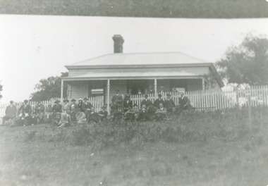
Document - MCCOLL, RANKIN AND STANISTREET COLLECTION: SHEEPSHEAD GULLY DOCUMENTS, 1859-1912
Documents; Envelope contains - Sale Note for land & dwellings, Lease No. 9048 Bendigo, Lease No. 9034 Bendigo, 1859 purchase of town lot, 1869 conveyance, 1896 conveyance, 1904 conveyance, 1906 conveyance. Sheepshead Gully Documents.MCCOLL RANKIN & STANISTREETorganization, mining, mccoll, rankin & stanistreet, lacey to deborah reef, mining lease no. 9034 and 9048, sheepshead bully, cornelius fahey to mr augustus weseloh deed no. 490, mrs anne robertson to mrs charlotte m.e. meager deed no. 918. -
 Buninyong & District Historical Society
Photograph - B/W photograph, Clifton Villa, Buninyong
Early house reflecting a degree of wealth, built for Buninyong Chemist around 1859historical and architectural elementsB/W photo of Clifton Villa, family dwelling built c 1859 cnr Eyre and Winter Streets Buninyong, lacework on barge boards and veranda, special feature chimneys. House built for Mr Newman,, chemist in Buninyong.clifton villa, house, garden, streetscape -
 Lakes Entrance Historical Society
Photograph - Historic House, 2000
Freeman family home originally situated on south side of Gray Street, western corner of lane. Relocated to Bulmer Street after Arceris bought site and extended the general store.Colour photograph of a timber dwelling at 10 Bulmer Street, which has gable roof, bay window in one front room, gable roof veranda over front entry. Timber picket fence. Lakes Entrance Victoriahouses, heritage study -
 Lakes Entrance Historical Society
Photograph - Historic House, 2000
Building was residence of State School teacher from 1890's. Typical of Education Department residence for teacher. During 1990's cladding and window frames were altered.Colour photograph of a timber dwelling with high pitched gable roof. Gablet ventilator in centre of roof. Narrow front veranda. Pretty garden beds enclosed with railway sleepers. Situated at 14 Bulmer Street, Lakes Entrance Victoriahouses, fences, heritage study -
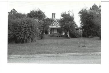
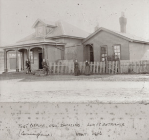 Lakes Entrance Historical Society
Photograph, Post Office Lakes Entrance 1906, 1906
Black and white photograph of Post Office and attached dwelling two men on bikes and two women in front of buildings named are Rex Harbeck and Miss Cook who was the Postmistress and her mother Mrs Cook Lakes Entrance Victoriapostal services, people, settlement -
 Halls Gap & Grampians Historical Society
Photograph - B/W, C 1902
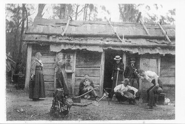
The dwelling is said to be the store at the Stoney Creek diggings, with some members of the Langley family. From left Alice Maria Langley, Lucy, ?, ?, Charles Langley (old man) & three friends.Photo shows three women and three men standing and sitting outside a slab hut. The roof of the hut appears to be constructed of bark, held in place by saplings. One of the men is sitting against the side of the hut and is holding a dog. Another man is crouched over a gold pan while an onlooker appears happy with the contents of the pan."Store at Stoney Creek diggings ?1902. Alice Maria Langley, Lucy ? ? Charles Langley (old man) & three friends." written on back in blue pen.people, langley, mining, gold mining -
 Tatura Irrigation & Wartime Camps Museum
Photograph - copy, Collivers Milk Bar, 1950
Copy of photograph of double fronted shop and side dwelling. Collivers Milk bar and mixed business. Note bikes; advertising signs on top of building. Window display always a feature.Black and white photograph of left hand side of shop, 161 Hogan Street, Tatura.on back: Collivers Milk Bar 1950 -
 Robin Boyd Foundation
Document - Manuscript, Robin Boyd, Living and Partly Living: The Neighbourhood; Synopsis – Robin Boyd, 1971
Discusses what is a neighbourhood and how is it "broken-down" for town-planning and building regulation purposes. Discusses types of dwellings, infrastructure, zone barriers, isolation of residential zones, services etc.Original manuscript of ideas for the chapter titled 'The Neighbourhood' (pp. 32-43) by Robin Boyd in the book "Living and Partly Living", by Ian McKay, Robin Boyd, Hugh Stretton and John Mant, published by Nelson, Sydney 1971.Typewritten (c copy), pencil edits, foolscap, 2 pagesneighbourhood, suburbia, neighbourhood, dwelling types, residential zones services, robin boyd, manuscript -
City of Kingston
Photograph - Colour, 6 March 1993
Edithvale is a suburb in the City of Kingston. It is located between Aspendale and Chelsea on the Port Phillip Bay and built within remnant areas of the Carrum Carrum swamp. The foreshore precinct comprises a wide sandy beach, with low sand dunes and numerous historic boat sheds. The suburb consists of older style dwellings and former holiday houses, combined with mid-century housing and newer homes. The large blocks are increasingly subdivided and the existing dwellings demolished to accommodate units and townhouses, thus changing the landscape of the area and reducing the tree canopy.The beachside suburb of Edithvale was previously part of the extensive Carrum Carrum Swamp. The area was once a source of fish and eels for the Mayone-Bulluk clan of the Bunurong people. Over time the area was drained and predominantly devoted to dairy farming and holiday houses. The farms were gradually sold and subdivided with a large number of homes built after World War II and in the 1960s. Edithvale is mainly residential with a shopping strip along Nepean Highway but little significant industry was ever established in the area apart from a plaster works and confectionary factory, both now closed.Laminated aerial colour photograph of Edithvale as viewed from Alexandra Avenue in the north to Ella Grove Chelsea/Edithvale in the south. regents Park Aspendale can be seen in the top left. The area is built-up with residential housing and facilities including Edithvale Primary School, numerous churches and the Edithvale Railway station. Large sections depict the remnant Carrum Carrum swamp. Edithvale Common and the former "Duck Inn" (Melbourne Water/Friends of Edithvale Seaford Wetlands) can be seen. Edithvale Recreational reserve, the valodrome and Edithvale Public Golf Course are prominent. The image shows vacant land in the area now known as Aspendale Gardens and the newer residential section of Chelsea Heights is not developed. A bike path has been established to cover the secondary drain. The Golf Links Court residential development located off Hughes Avenue is a large vacant block.Black type on white adhesive label: 6-3-93 Black type on white adhesive label: 25/9211, 6/3/93, 11.20 am Black type on white adhesive label: 9211 Yellow circular adhesive sticker Black pencil: 9211 6-3-93 arrow pointing Nedthvale, carrum carrum swamp, aspendale, chelsea -
City of Kingston
Photograph - Colour, Circa 1993
Edithvale is a suburb in the City of Kingston. It is located between Aspendale and Chelsea on the Port Phillip Bay and built within remnant areas of the Carrum Carrum swamp. The foreshore precinct comprises a wide sandy beach, with low sand dunes and numerous historic boat sheds. The suburb consists of older style dwellings and former holiday houses, combined with mid-century housing and newer homes. The large blocks are increasingly subdivided and the existing dwellings demolished to accommodate units and townhouses, thus changing the landscape of the area and reducing the tree canopy.The beachside suburb of Edithvale was previously part of the extensive Carrum Carrum Swamp. The area was once a source of fish and eels for the Mayone-Bulluk clan of the Bunurong people. Over time the area was drained and predominantly devoted to dairy farming and holiday houses. The farms were gradually sold and subdivided with a large number of homes built after World War II and in the 1960s. Edithvale is mainly residential with a shopping strip along Nepean Highway but little significant industry was ever established in the area apart from a plaster works and confectionary factory, both now closed.Aerial colour photograph of Edithvale as viewed from Alexandra Avenue in the north to Ella Grove Chelsea/Edithvale in the south. The area is built-up with residential housing and facilities including Edithvale Primary School, numerous churches and the Edithvale Railway station. Large sections depict the remnant Carrum Carrum swamp. Edithvale Common and the former "Duck Inn" (Melbourne Water/Friends of Edithvale Seaford Wetlands) can be seen. Edithvale Recreational reserve, the velodrome and Edithvale Public Golf Course are prominent. The image shows vacant land in the area now known as Aspendale Gardens and the newer residential section of Chelsea Heights is not developed. A bike path has been established to cover the secondary drain. The Golf Links Court residential development located off Hughes Avenue is a large vacant block.Yellow circular adhesive sticker on plastic Black ink (marker): * (asterisk) Black type on white adhesive sticker: P000108edithvale, aspendale, chelsea, carrum carrum swamp -
 Ballarat Heritage Services
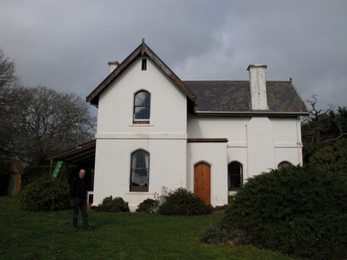
Photograph - Photograph - Colour, 'Astley', Daylesford, 2004, 15/06/2004
Wombat Park Estate began in 1854 when squatter William Edward Stan Ridge built a modest timber dwelling. It was transported to Daylesford in the 1930s. The garden was first planted in the early 1850s.A white double storey building in Daylesford called Astley. It was associated with the property "Wombat Estate". Caretaker Stuart Henderson stands in the garden.astley, daylesford, stuart henderson, stanbridge -
 Bendigo Historical Society Inc.
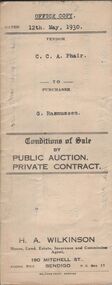
Document - H.A. & S.R. WILKINSON COLLECTION: CONDITION OF SALE
Conditions of sale by private contract dated 12th May, 1930 between C.C.A. Phair (seller) and G. Rasmussen (buyer) for land situate in Long Gully, together with 4-roomed weatherboard dwelling and all sundry. Price 225 poundsorganization, business, h.a. & s.r wilkinson real estate -
 Bendigo Historical Society Inc.
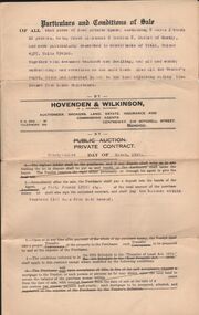
Document - H.A. & S.R. WILKINSON COLLECTION: CONDITION OF SALE
Conditions of sale by private contract dated 9th. August 1928 between A. Jacka and G Hogben for property at 31 Havelock Street, Bendigo described in certificate of registration No. 30696 together with 6-roomed weatherboard dwelling for the price of 525 pounds.organization, business, h.a. & s.r wilkinson real estate -
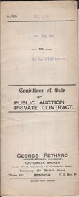
 Bendigo Historical Society Inc.
Document - H.A. & S.R. WILKINSON COLLECTION: CONDITION OF SALE
Condition of sale by private contract dated 23rd. March, 1929 between W. H. Moyle and H. A. Wilkinson for land in Epsom Certificate of title Volume 4375, Folio 874926 together with 4-roomed dwelling for the price of 600 poundsorganization, business, h.a. & s.r wilkinson real estate -
Whitehorse Historical Society Inc.
Article, Housing 'Monster' surprise, 2015
Whitehorse Council voted to approve a 118-dwelling development by Australia Hua Cheng Pty Ltd, Blackburn.Whitehorse Council voted to approve a 118-dwelling development by Australia Hua Cheng Pty Ltd, Blackburn, on the corner of Middleborough Road made up of two five-storey buildings and 15 double-storey buildings on the 7421 sm site.Whitehorse Council voted to approve a 118-dwelling development by Australia Hua Cheng Pty Ltd, Blackburn. city of whitehorse, massoud, denise, australia hua cheng pty ltd -
 Lakes Entrance Historical Society
Photograph - Historic House, 1999
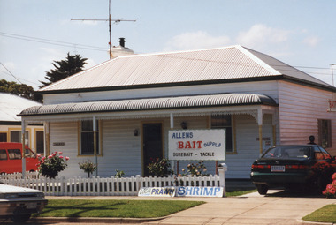
House built early 1900's by Don Mitchelson, brother of Leo Mitchelson, local builders.Colour photograph of timber dwelling at 11 Orme Street. Has hipped roof of corrugated iron, bull nose veranda across front, trimmed with wrought iron lace. Bait for sale notices at front fence. Lakes Entrance Victoriahouses, heritage study -
 Port Melbourne Historical & Preservation Society
Flyer, Save Port Melbourne Reduce Barak Beacon, 2024
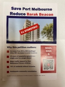
Flyer expresses residents concerns on proposed new increased heights and number of dwellings for the development which replace the low rise Ministry of Housing Sandridge Estate that had occupied the site since 1982.Half A4 size flyer has blue and red text on a white background and a photo of a tower block on the cover with '11storeys!!!'barak beacon, built environment - domestic -
 Linton and District Historical Society Inc
Photograph, Sussex Street, Linton, View to south-west, circa 1900
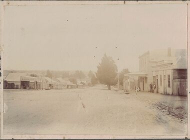
Shops on the left of the picture are: saddler (probably O'Sullivan at this time), butcher (probably G G Bennett), baker's shop (Nicol?), shop with verandah (originally 'Ellington House' owned by T M Wise), Preston's shop (with verandah, on corner of Sussex & Gillespie Streets), and Wishart's blacksmiths (on the far side of Gillespie Street). On the right, the buildings are E H Nicholls ("cheap grocer and seedsman"), the Surface Hill Hotel, Richard Ching's store and dwelling (grocer & produce merchant), and another shop without verandah (probably shop and dwelling owned by Annie Brown, née Nicholls).Original black and white photograph affixed to white backing paper which has then been mounted on grey card. The photograph shows the view along Sussex Street to the south-west. Two men are standing outside a shop on the rhs, and there appears to be a woman with a perambulator outside a building further along the street on the rhs.On back of original photograph: "g (or e) Bennett" (in blue pencil or chalk) / "LINTON STREET "(in ink) / "Elizabeth long ago" (in ink, with arrow pointing to blue writing).sussex street linton, o'sullivan's saddlery, g g bennett's butcher shop, nicol's bakery, ellington house [t m wise draper], preston's shop, wishart's blacksmiths, e h nicholls' store, surface hill hotel, richard ching's store, annie brown's shop, annie brown (née nicholls) -
 Bendigo Historical Society Inc.
Document - H.A. & S.R. WILKINSON COLLECTION: CONDITION OF SALE
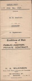
Conditions of sale by private contract dated 22nd May, 1930 between D.K Doxford (seller) and G. Rasmussen (buyer) for land situate in Charles Street, Bendigo, together with 5-roomed weatherboard dwelling and all sundry. Price 440 pounds.organization, business, h.a. & s.r wilkinson real estate -
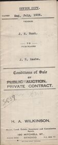 Bendigo Historical Society Inc.
Document - H.A. & S.R. WILKINSON COLLECTION: CONDITION OF SALE
Conditions of sale by private contract dated 2nd July, 1936 between J.H. Hunt (seller) and J.E. Raabe (buyer) for land situate No.7 Drought Street, together with 5-roomed weatherboard dwelling and all sundry. Price 475 pounds.organization, business, h.a. & s.r wilkinson real estate -
 Bendigo Historical Society Inc.
Document - H.A. & S. R. WILKINSON COLLECTION: CONDITION OF SALE
Conditions of sale by private contract dated 20th. February, 1926 between R. Rigby and H. A. Wilkinson for land situate in Allingham Street, Golden Square at present occupied by vendor together with 4-roomed weatherboard dwelling for the price of 225 pounds.organization, business, h.a. & s.r wilkinson real estate -
 Lakes Entrance Historical Society
Photograph - Coate/House, 1913c
Black and white photograph of the home of Isabella and Joseph Coate showing a dwelling with tiled gable roof, two chimneys with double pots, verandah at the front and sides topped with decorative frieze, seven workmen standing at front, on the Esplanade Lakes Entrance Victoria.genealogy, houses -
 Lakes Entrance Historical Society
Photograph - Historic House, 1999
Demolished, replaced with town houses. Occupied by Mrs Vass 1970's - 1980's.Colour photograph of a private residence at 44 Roadknight Street. Dwelling of timber with corrugated iron roof, external chimney. Appears to have been a hip roofed small fisherman's cottage, large gable roofed extension at front. Lakes Entrance Victoriahouses, heritage study -
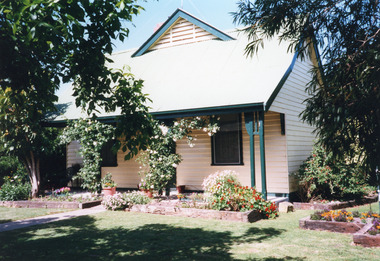
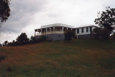 Lakes Entrance Historical Society
Photograph - Housing, 1999
Known as Powerlot, built by George Packer, a local builder for Jim McLaughlin in 1914. During Olsen family ownership house was altered. The two acre site once had landscaped garden and orchard. Flat roof has lead lined walkway for viewing lakes and sea. Story goes 'The German raider Wolf was observed signalling during WW1'.Colour photograph of a white painted timber dwelling set on a high vantage point at Stirling Road consisting of two wings, one with flat roof and veranda on three sides, the other more recently built has hipped roof. Metung Victoriahouses, heritage study -
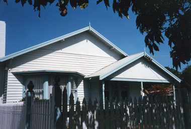
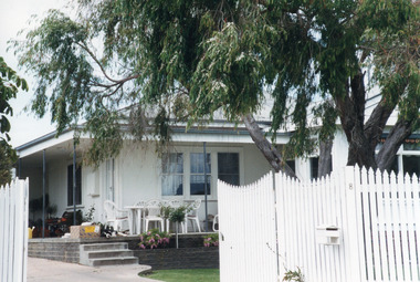 Lakes Entrance Historical Society
Photograph - Historic House, 2000
Building was lounge and ballroom for Robin Hood Inn, a popular guest house situated on corner of Esplanade and Carstairs Avenue. It was broken up, and components relocated, to make way for Sherwood Lodge Motel in 1958.Colour photograph of a fibro dwelling, hipped roof with gable extension, veranda over main room with triple sash window and French door. White timber picket fence and gate, situated at 8 North Arm Avenue, Lakes Entrance Victoriahouses, heritage study -
 Camperdown & District Historical Society
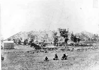
Photograph - Aboriginal people at Mt Leura, Camperdown, c1875
Three Djargurd Wurrung people on Country, pictured in front of Mt Leura, Camperdown c1875. This image also shows early primitive dwellings, Ower's flour mill (built 1868) and surviving native vegetation. Image of three Djargurd Wurrung people seated in front of Mt Leura, Camperdown, taken near corner of Scott and Curdie Streets c1875. On back: Early 1870s, Bought at first land sale Cr Scott & Curdie St, F.H. Grant, 11 Adeney Streetcdhs, djargurdwurrung, wombeetch puyuun, camperdown george, prince charlie, mount leura, mount sugarloaf, mt sugarloaf, ower's mill, cdhsfirstnations -
Stawell Historical Society Inc
Realia - Calender, Stawell News & Pleasant Creek Chronicle Calendar 1947, 1947
Postal Information in LSD. Phases of the moon, Full Month, Day Date,, Same for new moon. Borough and shire of Stawell, Councilors, Wards, Area, Population, Dwellings, Valuation Rates, etc. Public holidays for 1947Two colour Red and Black print on A2 Newsprint. Has 5 Squares X 3 Months, Days of week, and datesDane Bros. Grocers Advertisement. Est 1865. main Street Stawell Phone 39. Wholesale and Retail wine and spirit merchants. Sole Agents. Grasmere Butter. Farmer's Bacon, Hams, Small Goods. The absolute best always.