Showing 2003 items
matching early images
-
 Ballarat Tramway Museum
Photograph - Black and White photograph/s - mounted, John Phillips, late 1960's or early 1970's
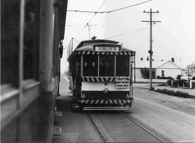
... Phillips late 1960's or early 1970's. Note image scanned in two...'s or early 1970's. Note image scanned in two runs through ...Yields information about the vicinity of the Drummond St south and the Urquhart St Loop.Black and White photograph mounted on heavy cardboard backing. Photo of Ballarat No. 31 crossing two single truckers in Drummond St. South, at Urquhart St. Loop. (Bell St?)) Tram 31 has destination of Sebastopol and has a "Trotting Bray Raceway Friday Night" auxiliary board on the front of the tram. Taken by John Phillips late 1960's or early 1970's. Note image scanned in two runs through a scanner, resulting in the shading in the image file.trams, tramways, sebastopol, drummond st. sth, urquhart st., tram 31 -
 Melbourne Tram Museum
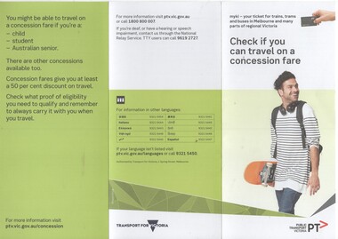
Pamphlet, Public Transport Victoria (PTV), "Check if you can travel on a concession fare", late 2017 to 4/19
... on a concession fare", issued late 2017 early 2018 with images... if you can travel on a concession fare", issued late 2017 early ....1 - Three fold, DL titled "Check if you can travel on a concession fare", issued late 2017 early 2018 with images of allowable concession cards, including senior and other concession card. ..2 - Five fold DL titled "Your go-to guide to myki" explaining the Myki system costs, types, the Explorer pack for visitors and has a map of the CBD Free Tram Zone. .3 - two fold DL titled "Explore the Night" giving details of night services for trains, trams, bus and coaches. .4 - three fold DL update of .1, issued April 19. Has contact details, languages and Transport for Victoria logo with PTV web address. Printed on recycled paper.trams, tramways, fares, tickets, myki, concession fares, public transport, free tram, night trams -
 Eltham District Historical Society Inc
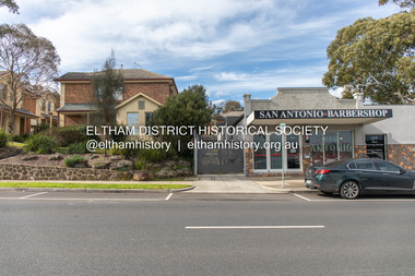
Photograph, Peter Pidgeon, 820 Main Road, Eltham, 2 Aug. 2022
... of the early images around the district of Little Eltham. Around 1930... of the early images around the district of Little Eltham. Around 1930 ...In 1855 the first post office opened in Eltham under the management of Thomas Hunniford. It was a weatherboard building located on the eastern side of Main Road just south of Bridge Street. During the 1880s under the managment of Hunniford's daughter, Anne, the building was modernised with a new awning and upper facade. In late 1925 a new brick building was erected immediately next door (820 Main Road). Following the death of Anne Hunniford in December 1928, J.N Burgoyne was appointed Postmaster. The extension to the right of the store was erected in 1939 for a new telephone exchange adjacent to the store and post office. A continuous telephone service operated by Mr Burgoyne and his family commenced operation 18 November 1939. Approximately 70 extensions were routed through the new exchange, 40 of which were transferred from the Greensborough Exchange. Entry to the exchange was via a separate door on Main Road or via the shop. The public telephone was initially mounted on the wall but later moved to the street. The present store is a barber shop and it remains, though heavily modified, one of only three remaining shop fronts from the early 1900s in Eltham. Comparison photo: SEPP_0700, 00140, SEPP_0701, SEPP_0702 Part of a presentation by Peter Pidgeon to the Society, 13 August 2022 showcasing a series of photographs taken by John Henry Clark over the period 1895 to 1930. John Henry Clark was the youngest of three boys born to William Henry Clark (1823-1877) and Maria White (1843-1914). He and his brothers, William Charles Clark (1872-1945), Clement Kent Clark (1874-1912) operated a photography business (Clark Bros.) from 25 Thomas Street, Windsor near Prahran during the period c.1894 to 1914. Following death of Clement in September 1912 and their mother in 1914, the Clark Bros business appears to have dissolved, the premises demolished, and a new house was under construction in 1915. John set up business independently in 1914 operating out of 29 Moor Street, Fitzroy where he is registered in the 1914 and 1915 Electoral Rolls. By 1916 John had relocated to Eltham where he continued his practice as a photographer and took many of the early images around the district of Little Eltham. Around 1930 John changed professions and opened a small cobbler's shop in 1931 near the pond opposite Dalton Street adjacent to the Jarrold family cottage. He never married and continued his profession as a bootmaker from this little shop, maintaining a close relationship with Mrs Jarrold for the rest of their lives. His bootmaker shop remains today beside the Whitecloud cottage and is one of only three remaining shops in the area from the early 20th century.Comparative photo taken 2022 with one taken from same location over 100 years earlier by noted local photographer J.H. ClarkBorn Digitaleltham, j.h. clark photo (2022), main road, 820 main road, burgoyne store -
 Eltham District Historical Society Inc
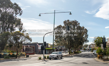
Photograph, Peter Pidgeon, Main Road, Eltham, 2 Aug. 2022
... continued his practice as a photographer and took many of the early... continued his practice as a photographer and took many of the early ...Comparison photo: SEPP_0610 - Main Road near Railway Station, c.1911 Shows Luther and Ada Haley’s General Store, Bakery and Tea Rooms opened September 1902 directly opposite present day Arthur Street. This was the first building in what is now Eltham’s present shopping town centre. Haley previously ran the General Store and Bakery on the corner of Main Road and York Street until his lease expired and the premises were bought by Mrs Sarah Burgoyne in 1902. Haley sold the store to Hannah Lloyd in 1917 who operated it until 1920. It then went through a succession of owners until Eric Staff purchased it in 1939. Ray Staff succeeded his father in 1954 and eventually demolished the store in 1965 opening up a new supermarket, the Eltham Big Star Food Centre. That building still stands at 929 Main Road and is the Nongkhai Thai Restaurant. On the eastern (right) side of Main Street is Haley’s Paddock, which was used on occasions for community picnics. Capable of holding 10,000 people, with ample shade and hilly surroundings it was an ideal place for any community gathering such as the State Schools’ Picnic in 1904. It was not until the early 1920s that stores started to appear between Luck and Dudley Streets. Part of a presentation by Peter Pidgeon to the Society, 13 August 2022 showcasing a series of photographs taken by John Henry Clark over the period 1895 to 1930. John Henry Clark was the youngest of three boys born to William Henry Clark (1823-1877) and Maria White (1843-1914). He and his brothers, William Charles Clark (1872-1945), Clement Kent Clark (1874-1912) operated a photography business (Clark Bros.) from 25 Thomas Street, Windsor near Prahran during the period c.1894 to 1914. Following death of Clement in September 1912 and their mother in 1914, the Clark Bros business appears to have dissolved, the premises demolished, and a new house was under construction in 1915. John set up business independently in 1914 operating out of 29 Moor Street, Fitzroy where he is registered in the 1914 and 1915 Electoral Rolls. By 1916 John had relocated to Eltham where he continued his practice as a photographer and took many of the early images around the district of Little Eltham. Around 1930 John changed professions and opened a small cobbler's shop in 1931 near the pond opposite Dalton Street adjacent to the Jarrold family cottage. He never married and continued his profession as a bootmaker from this little shop, maintaining a close relationship with Mrs Jarrold for the rest of their lives. His bootmaker shop remains today beside the Whitecloud cottage and is one of only three remaining shops in the area from the early 20th century.Comparative photo taken 2022 with one taken from same location over 100 years earlier by noted local photographer J.H. ClarkBorn Digitaleltham, j.h. clark photo (2022), main road -
 Ballarat Tramway Museum
Photograph - Black and White photograph/s - mounted, John Phillips, late 1960's or early 1970's
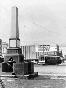
... late 1960's or early 1970's. Note: Image scanned in two... late 1960's or early 1970's. Note: Image scanned in two runs ...Black and white photograph mounted on heavy cardboard backing. Photo of Ballarat 26 outward bound to Victoria St., loading passengers just prior to crossing Grenville St. Tram has destination of "Victoria St". Has Big W (Woolworths) building in the background, along with the Ballarat Working Men or Labor (labour) monument (8 hour day) in the photograph. Taken by John Phillips late 1960's or early 1970's. Note: Image scanned in two runs through a scanned, resulting in the shading in the image file. .1 - ditto, mounted with four white Velcro dots on rear.trams, tramways, bridge st, grenville st, sturt st, monuments, tram 26 -
 Ballarat Tramway Museum
Photograph - Black and White photograph/s - mounted, John Phillips, late 1960's or early 1970's
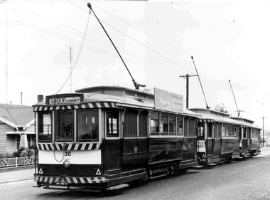
... late 1960's or early 1970's. Note image scanned in two runs... late 1960's or early 1970's. Note image scanned in two runs ...Yields information about the vicinity of the Mt Pleasant terminus.Black and White photograph mounted on heavy cardboard backing. Photo of Ballarat No. 30, 18 and another single trucker, possibly at the Mt Pleasant Terminus. Tram 30 has destination of "Gardens via Drummond North" and a SEC advertisement "Everything's under control in my all electric kitchen". Tram 18 has a advertisement for a Fete on an auxiliary board. Taken by John Phillips late 1960's or early 1970's. Note image scanned in two runs through a scanner, resulting in the shading in the image file. Two copies held to box 01-01-70., added 11/2005.trams, tramways, mt pleasant, tram 30 -
 Federation University Historical Collection
Book - Class Notes, A History of Architecture Grade I by R.D. Fraser, 1948, 1948
... (BC750-BC100) and Roman Architecture (BC146-BC365) Early...) and Roman Architecture (BC146-BC365) Early Christian Architecture ...R.D. Fraser was a student of the Ballarat Technical Art School, a division of the Ballarat School of Mines. Numerous hand written and hand drawn class notes from from the Ballarat Technical Art School. Topics include: Egyptian Architecture, Greek Architecture (BC300-BC700), Etruscan Architecture (BC750-BC100) and Roman Architecture (BC146-BC365) Early Christian Architecture Images include: Egypt, Great Pyramids, rock cut tombs, catacombs, Egyptian Temples, Development of a Pyramid, Egyptian Construction Methods, Greece, Greek Temples, Sloping Roofs, Doric Temples, Temple of Poseidon, Parthenon, arches, Acropolis Athens, Partenon, Ionic Volute, Propylaea, Erechtheion Athens, Corinthian examples, Greek Theatre, Optical Corrections in Architecture, The Greek House, Temple of Fortuna Virilis Rome, Maison Caree Nimes, Roman Circular Temples, Basilica of Trajan, Column of Trajan, Colosseum Rome, Basilica of Constantine, Roman Arched Structures, Romas Thermae at Romes, Arch and Wall construction, columns, mouldings Clemente Rome, S. Paolo Fuori le Mura Rome, Baptistery of Constantine Rome, S. Constanza Romearchitecture, art history, ballarat technical art school, r.d. fraser, alumni -
 Federation University Historical Collection
Photograph - Lantern Slides, Boxed Lantern Slides, c1920
... building * Eddystone Lighthouse, England * image of early printing..., England * image of early printing * Cloister Court, Trinity ...The lantern slides were most probably used at the Ballarat School of Mines. The image of Rome from St Peter's (Vatican) was taken before 1929. The "Via Conciliazione", built by Mussolini in 1929 is not present in the image. Hinged timber box designed to hold glass lantern slides. The box contains 50 lantern slides including: * male Turk in turbin *interior of a cathedral * Cavalry Scene, Boer War (c1900) * Richard Seddon portrait * Fishermen at Sea * Turkish domed building * Eddystone Lighthouse, England * image of early printing * Cloister Court, Trinity College, Cambridge * Farm Cove, Sydney Harbour (by I.F.E) * National Park, Sydney * Customs House, Sydney * View from the Dome of St Peter's, Rome (Pre 1929) * Botanical Gardens, Sydney * Coogee Bay, NSW * Keeble College Chapel, Oxford * Holy Land - The Village of Endor * Sydney Cove * Interior portrait of members of the Victorian Legislative Assembly, Parliament House, Melbourne * Palace Dela Concord, Italylantern slides, entertainment, ballarat school of mines, boer war, richard seddon, sydney harbour, coogee beach, legislative assembly, rome, roma, vatican, vaticono, fairyland, lake wendouree, glass slide, lantern slide -
 Bendigo Historical Society Inc.
Document - BARBARA MAMOUNEY COLLECTION: GOLDEN SQUARE METHODIST CHURCH PHOTOS AND DOCUMENTS
... earlier image of of Mines along New Chum Reef circa 1860... 'With Compliments' card enclosing as per earlier image of of Mines along New ...Green plastic folder with black plastic binding labelled PHOTOS RE HISTORY, opens with a list of 41 photos with their respective sizes in (inches) and (unrelated) numbers; then an A4 stapled pages re- an up-coming (Feb 27-29 2004) Cornish Families celebration, listing activities such as attending a 'meet the Cornish Concert', Festival Celebration Dinner, the Cornish Floral Dance, research one's own family history, follow the Cornish trail, Picnic in Rosalind park, and Meet the Bards of Cornwall; and buy a CD-ROM; followed by a hand-written time line or diary and business card for Harrison Print; 8 printing drafts with four names and years of birth and death; An image of some of Miss James' Sunday School Young mens' class from 1915 (photo taken at Royal Melbourne Show grounds Military camp); 9 GSUC accounts with letter-head; then an A4 off-white with Compliments card enclosing a black and white image with some names of a Golden Square Methodist Church Augustinian Fair Work-force; x2 smaller 'With Compliments' cards (one of paper) enclosing a black and white image (Circa 1860) of mines along the new Chum Line of Reef with GS Methodist Church in background; A newspaper cutting of line advertisement re- Golden Square Uniting Church celebrating 150 years of Methodism on the Goldfields citing its address and times of services; a collage of 3 black and white images dated Nov 1960 titled Church Activities; another collage of 3 slightly larger images taken around the same time of similar activities and showing numerous people around the church, and one of the pulpit; a sepia image of unidentified members of the church; fading copy of photo of Golden Square Methodist Church Choir behind which is a list of names of those in the picture though the list is dated 1960 the image looks pre-1960; handwritten list of Sunday School Teachers from 1957, no image; an A4 copy of one of the previous collage photos of outside the Church with numerous members, no names given; A4 image of GS Methodist church members, no names but minister appears 2nd row, third from left; a second copy of that image; Image of Band of Hope Conference, Bendigo, William Irving identified but undated; opportunity for naming those in image; A4 image with names and faces of Young Ladies Class of G.S.M.S.S. undated; 1/2 A4 size 'With Compliments' card enclosing as per earlier image of of Mines along New Chum Reef circa 1860; handwritten list of trustees from 1957, no image; collage of 2 images, one of previous shot of outside the church with members gathered, the other of the choir in action; copies of line ads for Bendigo Advertiser beginning with 30 July 1859 and relating to the Begelhole family and a list of Descendants of Henry William Bugelhoal / Begelhole on 3 stapled A4 typed pages, back to 1791; Another almost A4 image of the mines along the New Chum Line of Reef, with GSMC in the background; a smaller image of an unidentified marriage and Minister behind which is a larger image of the same; two versions of 1/2 A4 size 'With Compliments' cards, one of card enclosing images re- Commemorative pavers and associated memorabilia, and two women one of whom looks to be Barbara Mamouney. And one (with Comps) of paper with no image inside; a typed list of names of those in an undisclosed photo.golden square uniting church, the cornish in bendigo, list of photos (images) -
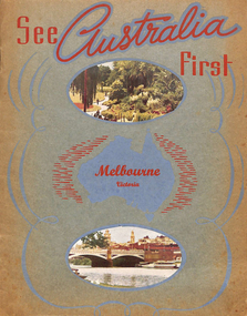 Melbourne Tram Museum
Book, Murray Views, "See Australia First - Melbourne Victoria", c1950
... Views of Gympie Qld, printed by Samuel Lee and Co. Images... to early 1950's. Features images of: Alexandra Gardens River ...Book - 16 pages, including grey card covers, titled "See Australia First - Melbourne Victoria" featuring 12 pages of postcard photographs of Melbourne. Inside rear cover has a details of Melbourne's history, the city and its features. Produced by Murray Views of Gympie Qld, printed by Samuel Lee and Co. Images post second world war - late 1940's to early 1950's. Features images of: Alexandra Gardens River Yarra and Princes Bridge Flinders St Station St Kilda Road - tram track work being undertaken Flinders St and the Forum theatre The Exhibition Buildings Collins St Parliament House Bourke St - with cable tram tracks and the Metropole Hotel, Myer, Foys Aerial view of Melbourne Captains Cook's Cottage St Kilda Road with W2 287 Burns Memorial St Kilda Road St Paul's and Princes Bridge Town Hall Royal Melbourne Hospital Collins St with W2 turning Queen Victoria Gardenstrams, tramways, melbourne, flinders st station, collins st, town hall, princes bridge, st kilda rd -
 Ballarat Tramway Museum
Photograph - Digital image Set of 13, Stuart Lodington, early BTPS operations and depot construction, 1975 - 1978c
... Set of 13 digital images of early BTPS operations and depot... tram 27 tram 38 tram 26 Set of 13 digital images of early BTPS ...Yields information about Ballarat Tramways and trams prior to the closure of the tramway system.Set of 13 digital images of early BTPS operations and depot construction, scanned from original slides by Stuart Lodington, 1974 to 1978c. .1 - Richard Gilbert and Gavin Young in No. 27 .2 - Richard Gilbert, Peter Bruce, Campbell Duncan, and others at the rear of the depot enjoying a drink. .3 - Richard Gilbert, Stuart Lodington, Gavin Young and Peter Rees in No. 27 .4 - as for No. 2 .5 - Richard Gilbert and Gavin Young on depot fan. .6 - Depot extensions, showing 4 and 5 roads, prior to any track laying of the pit track being built. .7 - Graeme Jordan lifting No. 38 on jacks .8 - front of new depot shed prior to any track construction .9 - King points laid into positron and queen points positioned .10 - Looking north inside shed across 4 road prior to any track laying .11 - spare motor and pinions at rear of shed. .12 - No. 26 at the Carlton St terminus, showing Sturt St West. .13 - ditto, looking north west.trams, tramways, btps, depot, carlton st, wendouree parade, tram 27, tram 38, tram 26 -
 Melbourne Tram Museum
Album - Photo Album, Melbourne & Metropolitan Tramways Board (MMTB), Construction of depots and workshops, mid 1920's
... . For individual photo images of each page see: \dbtext\hawthtramcoll... Painter Material /Early MMTB Depots-album images KCP01 to KCP20 ...Photo Album - brown manila card sheets as covers, containing 20 blue card sheets trimmed with white binding tape and held by two brass clips, containing the following photographs: South Melbourne depot - substation, construction, steelwork, inspection pits, offices, girders. overhead stores Preston Workshops - body shop, timber sheds, machine shop, steelwork, crane runways Sydney Harbour bridge steelwork. Three loose photos. For individual photo images of each page see: \dbtext\hawthtramcoll\photo collections\htd5526 - KC Painter Material /Early MMTB Depots-album images KCP01 to KCP20 KCP01_MMTB-depot-construction_cover.jpg KCP02_SouthMelbourne-1.jpg KCP03_SouthMelbourne-2.jpg KCP04_SouthMelbourne-3.jpg KCP05_SouthMelbourne-4.jpg KCP06_SouthMelbourne-5.jpg KCP07_PrestonWorkshops-1.jpg KCP08_PrestonWorkshops-2.jpg KCP09_PrestonWorkshops-3.jpg KCP10_PrestonWorkshops-4.jpg KCP11_PrestonWorkshops-5.jpg KCP12_PrestonWorkshops-6.jpg KCP13_PrestonWorkshops-7.jpg KCP14_PrestonWorkshops-8.jpg KCP15_PrestonWorkshops-9.jpg KCP15_PrestonWorkshops-10.jpg KCP16_Kew-extensions-1.jpg KCP17_Kew-extensions-2.jpg KCP18_OverheadDepot_SouthMelbourne.jpg KCP19_WaterTower_SouthMelbourne.jpg KCP20_SydneyHarbour-Unknown.jpgLetter "MMTB", "R T Alsop"? and "7" in ink on front cover as well as list of the photographs.trams, tramways, photo album, south melbourne depot, preston workshops, kew depot, sydney, substation, construction, buildings -
 Eltham District Historical Society Inc
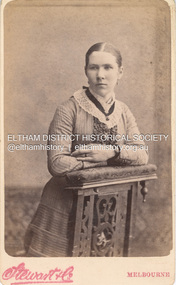
Photograph, Stewart & Co, Sarah Aldous (nee Shillinglaw), c.1882
... In this image Sarah appears young and has a wide wedding... melbourne In this image Sarah appears young and has a wide wedding ...In this image Sarah appears young and has a wide wedding band on her left ring finger which dates it to after her marriage to Charles Aldous in June 1880. By the mid 1880s dresses were becoming more tailor made and form fitting. Hair in the 1880 was plainly dressed, close to the head, with a small bun in the early eighties, and a higher one from 1885 suggesting early 1880s for this image, shortly after her marriage. A duplicate image is located on page 27 of the album. Stewart & Co operated from 217 Bourke St., East from 1871 to 1876 and from 217-219 from 1877 to 1889. Other locations included 42, 284 and 286. Overall, they operated in Melbourne from 1871 through at least 1910 though Carte-de-Visite photos were superseded by 1890. CARTE-DE-VISITE (cdv) 1857-1890 Cartes-de-visite (cdv's) are the most common form of photograph from the nineteenth century, generally measuring two and a half inches by four and an eighth inches (6.3 x 10.5 cm) when mounted, sepia toned, mounted on a card which was generally printed with the photographer's name and address on the back or beneath the portrait. - Frost, Lenore; Dating Family Photos 1850-1920; Valiant Press Pty. Ltd., Berwick, Victoria 1991marg ball collection, shillinglaw family photo album 1, 1871-1890, 1882, sarah aldous (nee shillinglaw 1854-1925), stewart & co photographers melbourne -
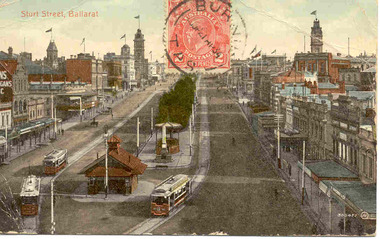 Ballarat Tramway Museum
Postcard, Valentine & Sons Publishing Co, Sturt St. from top of the Nichol and Allen Building in Grenville St, c1910
... . Image taken early in the days of the Ballarat electric trams..." is in the top centre of the postcard. Image taken early in the days ...Printed colour postcard of the east end of Sturt St. from top of the Nichol and Allen Building in Grenville St looking west. Titled "Sturt St Ballarat" in the top left-hand corner. Has three ESCo trams in the image, at the east end of Sturt St. In the bottom left-hand corner is the number "300477" and the initials "JV" within a circle. A 2d Australian stamp, cancelled with the postmark "Burnie Tas 21Ap 34" is in the top centre of the postcard. Image taken early in the days of the Ballarat electric trams, with no windows and no rooftop destinations. Appears to be the same tram possibly three times - looking at the number on the tram in detail. On the rear of the postcard is the address to a "Mme Helen Ferrando, Sori, Genova Italy" in black handwritten ink, while in the left-hand half of the postcard, typed in light purple ink is "Arthur H. Rubock, 23 Wilmot St., Burnie, Tasmania USCE 23897" (could be US Corps of Engineers) and the postmark of "Sori Genova. / 28.5.34". The printer of the card is "The Valentine & Sons Publishing Co. Ltd, Melbourne and Sydney" 2433.1 - Digital image of the same postcard from the Wal Jack album of Ballarat Photos - 5100-7-C, scanned as images .3 and .4 and high-resolution scans. On the rear in ink "Ballarat about 1912" and "Old type trams" 2433.2 - Card from Wal Jack to Ken Magor - see image 6 for a scan of the rear. Wal notes that the front of the cars have been outlined incorrectly. Yields information the buildings, buildings and scene at the intersection from Grenville and Sturt Sts looking west with three trams.Postcard - divided back, used with postage stamp on front. Two copies held along with a digital image. On the second copy, has Ken Magor's stamp and a note from Wal Jack to Ken.See images.trams, tramways, esco, sturt st, postcards, grenville st -
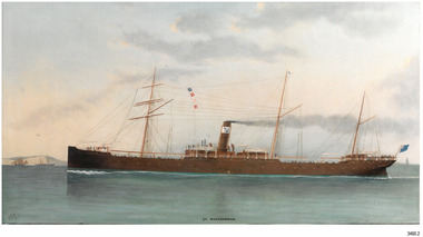 Flagstaff Hill Maritime Museum and Village
Photograph - Vessel, Sail and Steam Ship, S.S. Warrnambool
... This photograph and a matching earlier photograph...This photograph and a matching earlier photograph ...This photograph and a matching earlier photograph are the images of a painting of the British steamship SS Warrnambool at Dover Strait in the English Channel. The photographs were donated by the painting’s owner, who acquired the 30” x 56” (76 x 142.5 cm) oil on canvas painting in 1998. Both photographs were accompanied by a letter, one written in 2001, and the other in 2003. The letters confirm that the artist of the painting was Charles Keith Miller, signed with the initials “CKM” and dated “1893”. The painting shown in the photographs was a gift to the Town Council of Warrnambool, presented to Warrnambool folks in Melbourne on December 1, 1892, by the Captain of William Lund’s ship SS Warrnambool. The painting was given by Lund in appreciation of the Ladies of Warrnambool who had presented the ship with a ‘house’ flag bearing the Blue Anchor Line’s symbol of a diagonal blue anchor on a white background; the ladies had made the decision to present the flag only a month earlier. A few days later, December 6th, the SS Warrnambool was on its homeward journey to Britain, sailing via Adelaide. It anchored for a short time off the Port of Warrnambool. A boat was launched from Lady Bay to take a group of friends to the ship with a delivery of gifts. After cheers were roused for both the ship and the Captain, the ship continued on its way. The photograph shows the gifted white flag with a diagonal blue anchor flying from the masthead. The same symbol is painted on the ship’s black funnel. The signal flags on the foremast display ‘M’ ‘R’ ‘V’ ‘B’. These letters are most likely the ship’s call number ‘MRVB’. Although the painting was given as a gift in December 1892, it is post-dated “1893”. Perhaps the painting was given earlier than anticipated; or the date added later, but whatever the reason, the provenance of the painting was confirmed at auctions of this painting and other works by the same artist. CHARLES KEITH MILLER 1836-1907:- Captain Charles Miller left his home in Scotland at the age of 15 years for a life at sea. He earned his Master’s Certificate ten years later. After being the captain of sailing ships he moved over to the steamships because they were faster. In 1866 he married and settled in Glasgow. Over the following eleven years he and his wife had five children, then sadly his wife passed away. Captain Miller returned to the sea for a while but in 1888 he gave up his sea life to spend his time as a marine artist. His understanding of seafaring life and vessels, combined with his artistic skills, gave him the ability to produce fine art and several galleries and museums have collections of his sought-after works. S.S. WARRNAMBOOL 1892-1925:- The steamship SS Warrnambool was built in 1892 by the Sunderland Ship Building Company for the Lund Line of London, founded by William Lund in 1869. It efficiently carried both passengers and cargo across the world to Australia, under the command of her master Captain Joshua Edward Iibery, who had many years of experience with the Blue Anchor Line. The company, referred to as the Blue Anchor Line or BAL, owned a fleet of both sail and steamships. The funnels of all of the steamships were painted black, with a white band around the top bearing a diagonal blue anchor and chain. The company’s house flag was also white with a diagonal blue anchor. The SS Warrnambool carried passengers and cargo in a ‘no frills’ service to and from Europe around the Cape of Good Hope, stopping at some ports in between. The ship was involved in bringing home returned solders in 1895. At one time it carried a doctor from Victoria, Australia, to assist at the war front in South Africa. The ship had a very good reputation for its cargo arriving ‘almost always in excellent condition.’ Exported goods from Australia included iron safes, flour, wool, apples, frozen rabbits, butter, cheese, pork, cattle, poultry and sheep. One remarkable delivery contained Ostriches for Queen Victoria and they survived the journey well. The SS Warrnambool was sold in 1900 to the British and South American Steam Navigation Co. Ltd of Liverpool and was renamed ‘Harmodius’. The company was managed by R.P. Houston & Company of London and its Houston Line funnels were red with a black top. The Harmodius was sold in 1919 to K.S.S. Co. Ltd, managed by Kaye Son & Co. Ltd. of Liverpool, and was renamed ‘Kut’. The line had black funnels with a white ‘K’ in a diamond or between white stripes. In 1926 it was purchased by T.W. Ward Ltd. and broken up. NOTE- other vessels named “Warrnambool” Two other vessels carried the name “Warrnambool” (1)- HMAS Warrnambool J202 (1941-1947), a Bathurst Class corvette vessel owned by the Royal Australian Navy, destroyed by a mine. The photograph is significant for its association with the painting "SS Warrnambool" by well-known early 20th century marine artist Charles Keith Miller, whose paintings are well valued. The painting and the photograph of it are namesakes of Warrnambool and are connected through the gifts exchanged between the ship company owner, the City of Warrnambool and the Ladies of Warrnambool; the House Flag and the painting by C K Miller. The image is a good likeness to original photographs of the late-19th to early-20th century steam and sale vessel. Coloured photograph of a painting, the steamship S.S. Warrnambool. The three-masted ship has lowered sails. It is in calm water, land on one side, and other vessels in the water. The ship has four raised signal flags, a house flag and a blue ensign. The funnel also bears the house flags symbol. Smoke emits from the funnel. Figures are visible onboard. There is a signature and a title on the lower edge of the photograph. (Artist of the painting in the photograph was Charles Keith Miller)House flag symbol, [diagonal blue anchor on white background] Text "CKM" and "1893" Text "S. S. WARRNAMBOOL."flagstaff hill, warrnambool, photograph, steam ship warrnambool, flagstaff hill maritime village, shipwreck coast, ss warrnambool, captain, charles keith miller, ckm, 1893, william lund, warrnambool town council, blue anchor line, lund line, ladies of warrnambool, house flag, diagonal blue anchor, captain miller, sunderland ship building company, migrant ship, 1892 ship, home flag, bal, australian export, s.s.warrnambool, dover strait, english chanel, port of warrnambool, lady bay, mrvb, captain charles miller, captain joshua edward iibery, ostriches, queen victoria, british and south american steam navigation co., harmodius, r.p. houston & company, houston line, k.s.s. co. ltd, kaye son & co. ltd, kut, t.w. ward ltd -
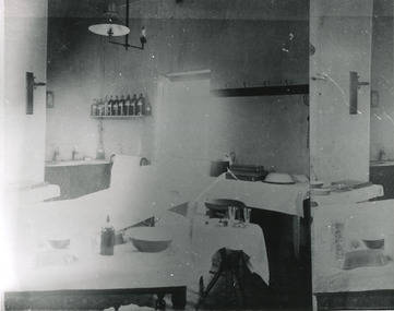 The Beechworth Burke Museum
Photograph, c. 1910
Taken approximately 1910, this black and white photograph shows the interior of the surgery and consulting rooms at the Mayday Hills mental hospital known at that time as a lunatic asylum in Beechworth. Mayday Hills Hospital, then known as the Beechworth Lunatic Asylum was constructed between 1864-67 designed by The Public Works Department. The hospital is made up of a number of buildings, landscaping, ha-ha, workshops, laundry, administrative facilities and farmland, it was constructed in 'Italianate' style by a team of up to two hundred and fifty workers (Woods p. 122). The asylum was established in response to the need for the regional shire to locally care for those particularly affected by their time working the Ovens goldfield during the Indigo Shire gold rush era where poor living conditions and isolation were significantly affecting the welfare of a great many people through poverty and lack of resources. The gaol and orphan labour systems were not able to effectively support to give housing, rehabilitation and ongoing care for the mentally ill, and transporting to Melbourne by waggon was a time consuming and counter-productive solution when the metro facilities were already overcrowded. According to Woods (A Titan's Field p. 122), between 1901 and 1911 a large percentage (thirty five percent in 1901 and twenty four in 1911) of the Beechworth population were either patients or inmates of Beechworth institutions, Mayday Hills accounted for some six hundred and seventy four patients in 1901, Beechworth's Mayday Hills was chosen as the site of Victoria's newest asylum, at the time, due to the landscape and altitude. The hilltop atmosphere and the native fauna, it was argued, would assist in the cure of the patients kept at the hospital (Wood 1985, 122). The positioning of the hospital had a beneficial effect on the rural town and the large volume of people living at the hospital and contributing to this population growth is counted as reason for the survival of Beechworth as a regional township. Mayday Hills continued to function as a mental hospital up until 1995 when it was sold to LaTrobe university. The building and grounds are listed on the Victorian Heritage Register under criterion A, B, D, E and F. Although grainy, the image gives a good indication of a functioning interior space of a surgery and consulting room at Mayday Hills in the early 1900's, from which we might interpret (from the types of tools and furniture present), the medical practices being performed at the time.Black and white rectangular photographmedical, asylum, surgery, hospital, beechworth, mayday hills, mayday hills asylum, mayday hills hospital, mental hospital, beechworth lunatic asylum, beechworth institutions, social welfare, public works department, consulting room -
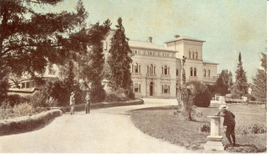 The Beechworth Burke Museum
Photograph - Postcard, George Rose, c. 1910
Produced c. 1910 by The Rose Stereograph co. This colourised photographic postcard shows the exterior of the administrative buildings at Mayday Hills mental hospital with three young boys in the foreground. This postcard forms part of the extensive Rose Series. (P. 4689) of postcards being produced by the Rose Stereograph co. which depicted landmarks from across Australia. Despite the early date attributed to this image, according to Walsh dates from this series place the postcards being produced typically between 1920-54. Mayday Hills Hospital, then known as the Beechworth Lunatic Asylum was constructed between 1864-67 designed by The Public Works Department. The hospital is made up of a number of buildings, landscaping, ha-ha, workshops, laundry, administrative facilities and farmland, it was constructed in 'Italianate' style by a team of up to two hundred and fifty workers (Woods p. 122). The asylum was established in response to the need for the regional shire to locally care for those particularly affected by their time working the Ovens goldfield during the Indigo Shire gold rush era where poor living conditions and isolation were significantly affecting the welfare of a great many people through poverty and lack of resources. The gaol and orphan labour systems were not able to effectively support to give housing, rehabilitation and ongoing care for the mentally ill, and transporting to Melbourne by waggon was a time consuming and counter-productive solution when the metro facilities were already overcrowded. According to Woods (A Titan's Field p. 122), between 1901 and 1911 a large percentage (thirty five percent in 1901 and twenty four in 1911) of the Beechworth population were either patients or inmates of Beechworth institutions, Mayday Hills accounted for some six hundred and seventy four patients in 1901, Beechworth's Mayday Hills was chosen as the site of Victoria's newest asylum, at the time, due to the landscape and altitude. The hilltop atmosphere and the native fauna, it was argued, would assist in the cure of the patients kept at the hospital (Wood 1985, 122). The positioning of the hospital had a beneficial effect on the rural town and the large volume of people living at the hospital and contributing to this population growth is counted as reason for the survival of Beechworth as a regional township. Mayday Hills continued to function as a mental hospital up until 1995 when it was sold to LaTrobe university. The building and grounds are listed on the Victorian Heritage Register under criterion A, B, D, E and F. Through the colourisation of the photograph and through the unusual choice of the subject matter being used as a postcard, we can get a good indication of aesthetic interests of the time.Rectangular coloured photograph printed as postcardObverse: Beautiful / Beechworth / (Vic.) / 1800 ft. / above / Sea / Level / - / Asylum / for / insane / (Front / View) / Copyright. / F. / Foxcroft / Photo Reverse: 1997.2454 / Postcard / THIS / SPACE / MAY / BE / USED / FOR / CORRESPONDENCE: / THIS / SPACE / FOR / NAME / AND / ADDRESS / STAMPpostcard, rose series, mayday hills hospital, mayday hills, beechworth lunatic asylum, photographic postcard, george rose, the rose stereograph co., social welfare, welfare services, ovens goldfield, lunatic asylum, the public works department, australian landmark, regional shire, indigo shire council, gold rush, beechworth institution, victorian heritage register -
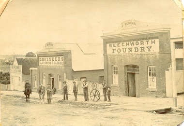 The Beechworth Burke Museum
Photograph, c1900
The Beechworth Foundry was vital to the industry of the town and surrounding district in the early years of the town’s development. Originally opened as the New Ford Street Foundry by A. Roger in 1858, J Duncan and M Straughair amalgamated and established the Beechworth Foundry in 1867. The business was extensive and operated out of many buildings, each with their own specialisation. All of the buildings pictured in this image are part of the larger Beechworth Foundry. In the late 1860s it employed 16 men. The foundry was fundamental to the running of the town and surrounding district, as it manufactured all manner of items, including tools and machinery for the mining and agricultural industries. The foundry business collapsed in 1896 after the death of it’s founder, John Duncan, the same year (Straughair had died in 1882). The foundry was reopened by W H Phillips in 1905 and taken over by H Delora in 1906 This image is significant as it shows some of the many buildings of the Beechworth Foundry, which was a fundamental business to the running of the town and surrounding district, and supplied many of the tools and machines required for the mining and agricultural industries, as well as other aspects of life between the 1850s and early 1900sSepia rectangular photograph printed on paper. It has rough, torn-looking edgesReverse 97.2321 / BMM A03115duncan, john duncan, j duncan, m straughair, straughair, foundry, beechworth foundry, industry, factory, newtown, new ford street foundry, a roger, roger, w h phillips, phillips, w phillips, h delora, delora, metalwork, farming and agriculture, tools, mining, workmen -
 The Beechworth Burke Museum
Photograph, c. 1870
This photograph was captured at an undisclosed location and at an unidentified time but likely dates to approximately 1870. The photographer's details are not recorded and the identities of the men in the image are also not known. This image depicts a group of 10 men in typical miners fashion. Four of them are sat on a large log with one holding a small dog. Six miners stand behind those sitting. All these men are wearing a white button-up shirt and tan coloured work trousers. They wear heavy boots and seven have included a dark vest over their shirt. The man holding the dog has a pipe in his mouth. Two of these men are clean shaven with the remainder sporting a moustache and two with a beard. The ages of these men vary from late 20s to middle age. This group of men are located in a mining location with what appears to be an open cut mine in the background of the image. The ground is muddy and has elements which can help identify it as a mining location based on the condition of the landscape. The bottom of the men's trousers are muddy which provides the assurance that these men were working in this location when their photograph was captured. In the background there is one structure, possibly a dwelling, and bush which identifies the location as Australia. Open cut sluicing is a method used to extract gold and other precious metals from beneath the surface of the earth. This technique involved the use of high-powered hoses which broke down the soil enabling miners to come along and search this soil for gold. After the gold rush of the early 1850s, diggers had to enlist the assistance of heavy machinery and techniques like hydraulic sluicing in order to reach gold because the surface alluvial gold had already been discovered and removed. This heavy machinery was not used until after 1853. The search for gold is ingrained into the history of Victoria and therefore, images like this one which portray an open cut sluicing site can reveal important information for society and technology for the date when the photograph was taken. This image is of important historical significance for its ability to convey information about sluicing and the methods used to find gold in the late 1800s and early 1900s. It also shows a location where sluicing was undertook which provides insight into the impact of sluicing on the environment at a time when it was done. Images, like this one, of Australian gold rush history can reveal important information about the social and environmental impact of this period. This image depicts diggers standing in a mining location and therefore, this image has the capacity to reveal or support significant information for researchers studying the fashion and social status of diggers in Australia in approximately 1870. It can also provide information on the landscape of Australia in this period and the impact of mining for gold on both society and the Australian landscape. The Burke Museum is home to a substantial collection of Australian mining photographs which can be used to gain a deeper understanding into life on the gold fields, technology used in mining, the miners themselves and the impact of the gold digging on the environment.Sepia toned rectangular photograph printed on matte photographic paper mounted on board.Reverse: 1997.2518mining, goldfields, beechworth, 1870, australia, australian goldfields, diggers, victoria, sluicing, gold mining, miners, diggers victoria -
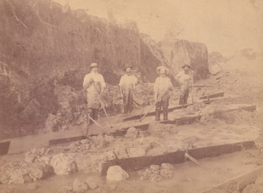 The Beechworth Burke Museum
Photograph, c.1870
This photograph was taken in approximately 1870 and depicts four male miners standing in mining sluice at the Three Mile Goldfields. These men are wearing typical attire for 1870s gold miners. They wear white shirts, tan coloured pants with water proof shoes and most of the men are wearing an apron to prevent their clothing from becoming too dirty from the mud. Each man is wearing a wide brim hat and hold large wooden tools used for sorting through the sluice. Three of the four men have full beards. The photograph was donated to the Burke Museum by R. Ziegenbein before 2001 but the photographer and the individuals captured in the photo are unknown. The image depicts the landscape of the Three Mile Goldfields during a period when open cut sluicing was undertaken to reach gold. Open cut sluicing is a method used to extract gold and other precious metals from beneath the surface of the earth. This technique involved the use of high-powered hoses which broke down the soil enabling miners to come along and search this soil for gold. After the gold rush of the early 1850s, diggers had to enlist the assistance of heavy machinery and techniques like hydraulic sluicing in order to reach gold because the surface alluvial gold had already been discovered and removed. This heavy machinery was not used until after 1853. The Three Mile Goldfields was a site of rich alluvial gold deposits located about 5 km south of Beechworth in Victoria. Today, the location of this gold deposit is called Baarmutha. It was a popular area for gold mining in the 1850s but became largely abandoned by the following decade. In 1865, a man named John Pund recognized that the area could be potentially rich if a better water supply could be obtained. He secured a 15 year license with three other miners. Within the next five years, these men had constructed 19 km of water race going from Upper Nine Mile Creek to Three Mile Creek. By 1881, these four men had delivered 950,000 gallons to the Three Mile Sluicing area which is depicted in this photograph. Pund was later go into partnership with John Alston Wallace who would become owner of the Star Hotel in Beechworth. The Three Mile sluicing location continued to be operational until 1950. Sluice box workers were a vital part of gold mining regardless of how inefficient they were in the recovery of gold. After using hydraulic sluicing to cut away the earth, miners would use the big wooden boxes depicted in the image to catch the earth which would then be sifted for gold. However, accidents would occur often which would result in the gold washing away and unable to be recovered. It was not a very efficient system because the gold, which was alluvial and thus very fine, would often pass through the sluice box undetected.The search for gold is ingrained into the history of Victoria and therefore, images like this one which portray an open cut sluicing site can reveal important information for society and technology for the date when the photograph was taken. This image is of important historical significance for its ability to convey information about sluicing and the methods used to find gold in the late 1800s and early 1900s. It also shows a location where sluicing was undertook which provides insight into the impact of sluicing on the environment at a time when it was done. Images, like this one, of Australian gold rush history can reveal important information about the social and environmental impact of this period. This image depicts diggers standing in a mining location and therefore, this image has the capacity to reveal or support significant information for researchers studying the fashion and social status of diggers in Australia in approximately 1870. It can also provide information on the landscape of Australia in this period and the impact of mining for gold on both society and the Australian landscape. The Burke Museum is home to a substantial collection of Australian mining photographs which can be used to gain a deeper understanding into life on the gold fields, technology used in mining, the miners themselves and the impact of the gold digging on the environment.Sepia toned rectangular photograph printed on matte photographic paper and mounted on board.[illegible] about 1870 / 97 2514.1 / 2594 30three mile goldfields, goldfields, 1870, 1870 gold, australia, australian landscape, miners, gold miners, diggers, gold diggers, beechworth, victoria, sluice box workers, sluicing, sluice, mining -
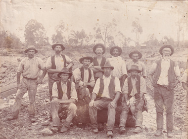
 The Beechworth Burke Museum
Photograph - Photograph - Reproduction, W. D. Gibbon, Early 1900s
This photograph was taken in 1911 at Three Mile Creek, about five kilometers south of Beechworth town. Significant digging took place at this location from late 1855, which led to a flood of workers and stores to follow, though daily earnings were slim compared to the nearby Woolshed site. This remained the case even after workers at Three Mile Creek attempted to protest around Beechworth during an election in November 1855. Three Mile Creek was one of seven significant divisions of the Beechworth Mining District formalised by the Governor-in-Council in 1858, though by the time this photograph was taken, the boundaries of the original seven districts had shifted to create seventeen divisions. The Three Mile Goldfields was a site of rich alluvial gold deposits located about 5km south of Beechworth in Victoria. Today, the location of this gold deposit is called Baarmutha. It was a popular area for gold mining in the 1850s but became largely abandoned by the following decade. In 1865, a man named John Pund (a man second from the left in the back row of this photograph shares this surname) recognized that the area could be potentially rich if a better water supply could be obtained. He secured a 15 year license with three other miners. Within the next five years, these men had constructed 19 km of water race going from Upper Nine Mile Creek to Three Mile Creek. By 1881, these four men had delivered 950,000 gallons to the Three Mile Sluicing area which is depicted in this photograph. Pund would later go into partnership with John Alston Wallace who would become owner of the Star Hotel in Beechworth. The Three Mile sluicing location continued to be operational until 1950. The eleven miners in this photograph are: Back row: Led Guthrie, P. Pund, F. Beel, [Unknown] Miller Front row: Paddy McNamara, J. King, W. Beel, [Unknown] Garland, J. Clarke, J. Ryan, H. Bartsh In the background of the photograph is a huge dirt wall that appears to suffer damage caused by hydraulic sluicing. Hydraulic sluicing is a specialised mining technique that involves directing high pressure water flows at dirt to uncover gold. The technique played a significant role in shaping Beechworth's landscape during the gold rush to create the topography seen today.The search for gold is ingrained into the history of Victoria and therefore, images like this one which portray an open cut sluicing site can reveal important information for society and technology for the date when the photograph was taken. This image is of important historical significance for its ability to convey information about sluicing and the methods used to find gold in the late 1800s and early 1900s. It also shows a location where sluicing was undertook which provides insight into the impact of sluicing on the environment at a time when it was done. Images, like this one, of Australian gold rush history can reveal important information about the social and environmental impact of this period. This image depicts diggers standing in a mining location and therefore, this image has the capacity to reveal or support significant information for researchers studying the fashion and social status of diggers in Australia in approximately 1911. It can also provide information on the landscape of Australia in this period and the impact of mining for gold on both society and the Australian landscape. The Burke Museum is home to a substantial collection of Australian mining photographs which can be used to gain a deeper understanding into life on the gold fields, technology used in mining, the miners themselves and the impact of the gold digging on the environment.Black and white / sepia rectangular reproduced photograph printed on glossy photographic paper mounted on board.beechworth, beechworth museum, mining, mining team, three mile creek, sluicing, hydraulic sluicing, photography, gold sluicing, gold mining, pund mining -
 The Beechworth Burke Museum
Photograph - Photograph - Reproduction, 1890-1900
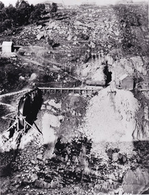
The photograph appears to depict the of the entrance to the Rocky Mountain Tunnel. The Rocky Mountain Tunnel runs from opening of the tunnel, underneath the Beechworth town, to the Gorge. This tunnel drained the excess water from the upper Spring Creek Goldfield to allow for mining access in the area. The Rocky Mountain Co. blasted through the granite rock to create the original 400ft-long tunnel in 1859, but between 1867 and 1871, the Rocky Mountain Gold Sluicing Co. widened and extended it. At its completion, it measured 14ft deep, 6ft wide, and almost half a mile long. The mining surveyor at Beechworth called it 'without doubt, the greatest undertaking of the kind in the colony'. When the company became the Rocky Mountain Extended Gold Sluicing Co. in the mid-1870s, they continued the tunnelling work. The work was reportedly vital to mining being able to continue at Beechworth and may have established world records in tunnelling through hard rock. The entrance at the Gorge side of the tunnel can be seen from the Beechworth Gorge Walk. The tunnel continues to be an outfall drain for the lake and the town.The search for gold is ingrained into the history of Victoria and therefore, images like this one which portray an open cut sluicing site can reveal important information for society and technology for the date when the photograph was taken. This image is of important historical significance for its ability to convey information about sluicing and the methods used to find gold in the late 1800s and early 1900s. It also shows a location where sluicing was undertook which provides insight into the impact of sluicing on the environment at a time when it was done. The Burke Museum is home to a substantial collection of Australian mining photographs which can be used to gain a deeper understanding into life on the gold fields, technology used in mining, the miners themselves and the impact of the gold digging on the environment.A black and white rectangular reproduced photograph printed on matte photographic paper.7814beechworth, beechworth museum, burke museum, australian museum, mining, rocky mountain mining co., rocky mountain mining company, mine, mining company, rocky mountain mine, mine entrance, rocky mountain, gold, gold mining -
 The Beechworth Burke Museum
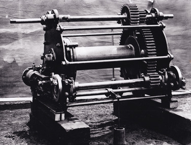
Photograph - Photograph - Reproduction, c.1870s
This photograph shows a piece of gold mining equipment identified as a mine winch, possibly an air winch cylinder of 1870s RG Ford's Patent design. Throughout the history of mining for gold and other precious materials, the windlass or winch (pictured) was used to bring up buckets full of soil from the bottom of a mine. This soil was then searched for gold/metals before being relocated to a different area. Due to the size and complexity of this particular piece of equipment, this winch may have been used to raise and lower mine carts to the entrance of the mine (often used in coal mining) and could have been used in raising cages up and down (acting as elevators) containing miners if the mine was particularly deep. The actual use of this particular item in the Beechworth locality is undocumented but these are some possibilities based on the use of these pieces of equipment in other mining locations. Mining can have a largely detrimental impact to the environment and therefore, the study of machinery like the one depicted in this photograph can help researches to reconstruct the methods and technologies used in the late 1800s and early 1900s. This particular item appears to have been removed from it's original site where it would have been used to assist with mining. It is possible that this photograph has been taken for recording purposes or as part of a machinery exhibition. Prior documentation records that this piece of equipment had connections to the Rocky Mountains Mining Company. Today, the Rocky Mountains Gold Mining company is famous in Beechworth for having been instrumental in the creation of the Rocky Mountain tunnel. Construction for this tunnel began in 1859 when a group of 12 men blasted a 400ft long tailrace though the rock beneath the town of Beechworth. Today, the 800ft tunnel, completed in 1871, is a popular tourist attraction but during the decades of gold mining, the purpose of this tunnel was to divert water away from the main sluicing operations so miners could better access gold and precious materials. The tunnel was used for this purpose for many years, later becoming useful for the Zwar Brother's tannery and currently as an outfall drain for Lake Sambell. This area continued to be mined until the early 1900s. The period when this item was in use is unclear but it is estimated to have been in the 1870s based on the design and appearance of the image. The gold works at the Rocky Mountain Tunnel closed in the early 1920s but the impact of mining remains in Beechworth today and therefore the study of photographs like this one which contain mining equipment can further understanding of mining in this region.This photograph has historic and research potential for study on the gold mining of the Beechworth region and types of equipment used to locate gold after the initial gold rush of 1853-1854 which resulted in the discovery of the surface gold and required miners to dig deeper to access precious metals. The clarity of the photo, and its good preserved condition, means it can continue to be used for research. This photo is part of a collection of six photos all within the Burke Museum Collection which depict mining equipment.Square black and white photograph on card.7793.1beechworth, mining, goldmining, goldmining equipment, beechworth burke museum -
 The Beechworth Burke Museum
Photograph, unknown
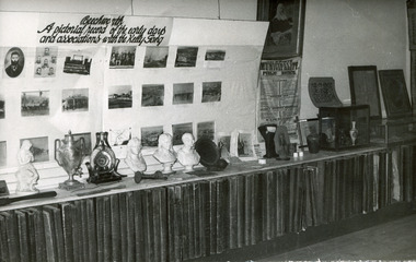
This photograph was taken in the Burke Museum c1970 and depicts an exhibition about the Kelly Gang. This photograph is of social significance due to its connection with the Burke Museum as well as the Kelly Gang. The Kelly Gang story is integral to the formation of an Australian identity and highlights the Irish oppression during the 1800s. Ned Kelly is an Australian icon, mythologised in Australian literature, art, folklore and history, and the Kelly Gang story permeates Australia's national consciousness. The Burke Museum is significant here also, as the image shows the importance of the Kelly Story to the Beechworth area and local identity. This photograph is also of research potential due to the great interest in the Kelly Gang history in Australia, and also for its presentation of a historical museum exhibition in Beechworth.Black and white, rectangular photograph, printed on photographic paperObverse: Beechworth/a pictorial record of the early days/and associations with the Kelly Gang Reverse: BMA03314 1997.3125/Agfaned kelly, kelly gang, burke museum, australia, museum, display, photograph, pictorial record, beechworth municipality, beechworth, exhibit, bust, clock, urn, vase, painting -
 The Beechworth Burke Museum
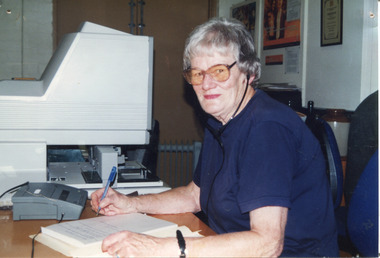
Photograph, c2000s
The photograph records that this image is of Pat White, cataloguer and performer of other duties at Burke Museum for a number of years. Pat White was involved in the Oral History project at Burke Museum and was tasked with transcribing the recordings of elderly Beechworth residents recalling their early days in the town. Estimated date of photo is 2000.This photograph is of social significance because it depicts a local Burke Museum volunteer, Pat White, who had a connection to the Beechworth area. It also reveals museum practices at Burke Museum in 2000, specifically the equipment and technology used to record and transcribe oral stories, which is of interpretive value when considering the ways in which museum practice has changes over the last 20 years.Colour rectangular photograph printed on paper.Obverse: (illegible) Reverse: Museum volunteer profiles / Pat White / When the original meeting was held to tell us of the proposed Oral / History Project I thought it was a very good idea and one in which I / would like to be involved. I have enjoyed transcribing tapes that Jennifer / Williams has made while interviewing older residents of Beechworth. / The ‘oldies’ have a lot to five back to Beechworth in telling of their early / days in the town. I have learnt a great many things I did not know / about Beechworth’s early history through these people and have enjoyed my / hours of work listening to them. beechworth, burke museum, cataloguing, oral history, elderly residents, pat white, patricia white, recordings -
 The Beechworth Burke Museum
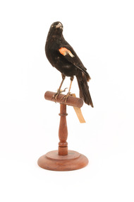
Animal specimen - Red-Winged Blackbird, Trustees of the Australian Museum, 1860-1880
The red-winged blackbird is native to North America. They live in a verity of places from southern Alaska at its northern most point, to the Yucatan peninsula in the south and covers the greater part of the continent reaching from the Pacific coast of California and Canada to the eastern seaboard. Populations that are most northerly migrate south after the mating season, but some of the populations in the central and western United States, Central America and the Gulf Coast are resident year-round. In the breeding season, Red-winged blackbirds are found in a range of fresh and saltwater environments, including in small trees and bushes along marshes and watercourses, in agricultural areas and dry meadows. During migration, they can be found in, pastures, prairies and cultivated fields. They are polygamous. In the north, the early arrival and tumbling song of these birds are welcome indications of spring's return. The Red-winged blackbirds are known for their scarlet and yellow shoulder patches on this specimen are rather dull and the feathers are not as glossy black as they are in other images. This specimen is part of a collection of almost 200 animal specimens that were originally acquired as skins from various institutions across Australia, including the Australian Museum in Sydney and the National Museum of Victoria (known as Museums Victoria since 1983), as well as individuals such as amateur anthropologist Reynell Eveleigh Johns between 1860-1880. These skins were then mounted by members of the Burke Museum Committee and put-on display in the formal space of the Museum’s original exhibition hall where they continue to be on display. This display of taxidermy mounts initially served to instruct visitors to the Burke Museum of the natural world around them, today it serves as an insight into the collecting habits of the 19th century.This specimen is part of a significant and rare taxidermy mount collection in the Burke Museum. This collection is scientifically and culturally important for reminding us of how science continues to shape our understanding of the modern world. They demonstrate a capacity to hold evidence of how Australia’s fauna history existed in the past and are potentially important for future environmental research. This collection continues to be on display in the Museum and has become a key part to interpreting the collecting habits of the 19th century.This is one of the most common birds in North America and is the most boldly coloured one. The males are glossy-black with shoulder patches of scarlet and yellow which they are able to puff up or hide according to their level of confidence. Females look like a big, dark sparrow, being a subdued, streaky brown. This specimen has the colouring of the male Red-Winged Blackbird which helps to identify it as such.Swing-Tag: 137a. / Red-winged Starling / Catalogue page, 58 / Tag: A. 4429taxidermy mount, taxidermy, animalia, burke museum, beechworth, australian museum, skin, reynell eveleigh johns, bird, american birds, north america, red-winged blackbird, red-winged starling, migratory, alaska, canada, saltwater -
 The Beechworth Burke Museum
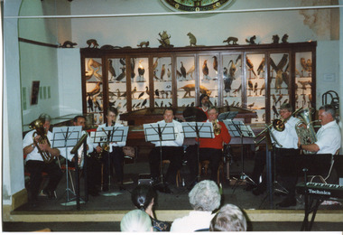
Photograph, 1999
This photograph depicts members of the Beechworth Band at a 'Liedertafel' concert in the main hall at the Burke Museum in 1999. The concert was associated with an exhibition titled, 'From the Liedertafel to the Skating Rink: Entertainment in Beechworth 1852 - early 1900s', which celebrated the rich and diverse entertainments that were a part of Beechworth life in the nineteenth and early twentieth centuries. Marching bands, choirs, circus acts, theatrical performances, races, and seasonal activities, such as Mr. Spiller's roller skating rink, founded in the late 1860s, were among the attractions on offer. 'Liedertafel' is a tradition that accompanied German settlers to Australia. It refers to a friendly society of men united by an enthusiasm for singing. The Beechworth Brass Band was formed by Mr. H. Vandenberg in 1887. The Beechworth Liedertafel was established 14 March 1894 at the London Tavern, Camp Street, Beechworth, by Mr. A.A. Billson, and a visiting conductor, Mr. H. Fielder. German clubs, complete with marching bands, athletics associations and Liedertafel choirs, were centres of social activity attracting wide audiences not limited to members of their own ethnicity. Alfred Arthur Billson was the youngest son of Mr. George Billson, who served as Beechworth’s mayor between 1869-1871. In 1872, George purchased the Oven’s Brewery in Last Street, which became Billson’s Brewery, one of the oldest continuing beverage manufacturers in Australia. An active member of Beechworth’s cultural, business and political life around the turn of the century, A.A. Billson served on Beechworth Shire Council from 1884 to 1893, and from 1895 to 1910, with three terms as president (1888–89, 1899–1901, 1908–09). He founded the Beechworth Progress Association in 1891 and produced an ‘Illustrated Guide to Beechworth and Vicinity’ to develop tourism potential. This photograph of the Beechworth Band playing at the Burke Museum is historically significant for the information it conveys about an exhibition at the Burke Museum between September and November 1999. The use of the contemporary Beechworth Band in a 'Liedertafel' performance provides insight into curatorial approaches at the turn of the twenty-first century and improves our understanding of how exhibitions use objects in the Burke Museum's Collection to tell stories about the past in the present. The image is historically and socially significant for attesting to the enduring appeal of local musical associations, which were a popular means of entertainment that fostered social connections among settlers from diverse ethnic backgrounds. Rectangular colour photograph printed on matte photographic paper. Reverse: 7029 / Label: 7029 / Source / Burke Museum / Beechworth / Band / 1999/2000 /liedertafel, beechworth band, burke museum, from the liedertafel to the skating rink, entertainment in beechworth 1852 - early 1900s, gold rush, immigration, beechworth's german heritage, london tavern beechworth, beechworth's first brick tavern, spiller's skating rink, vandenberg's beechworth brass band, protestantism, teetotallism, skating carnivals, beechworth german association, yma's, beechworth skating rink, progress societies, billson's brewery, german-australians, beechworth progess association, lodges, freemasonry, colonial australia -
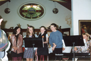 The Beechworth Burke Museum
Photograph, c1999/2000
This photograph depicts female singers accompanied by members of the Beechworth Band at a 'Liedertafel' concert in the main hall at the Burke Museum in 1999. The concert related to an exhibition titled, 'From the Liedertafel to the Skating Rink: Entertainment in Beechworth 1852 - early 1900s', which celebrated the rich and diverse entertainments that were part of Beechworth life in the nineteenth and early twentieth centuries. 'Liedertafel' is a German tradition that accompanied European settlers to Australia. It refers to a friendly society of men united by an enthusiasm for singing. The Beechworth Liedertafel was established 14 March 1894 at the London Tavern, Camp Street, Beechworth, by president, Mr. A.A. Billson, and a visiting conductor, Mr. H. Fielder. The Beechworth Brass Band was formed by Mr. H. Vandenberg in 1887. Marching bands, choirs, circus acts, theatrical performances, races, and seasonal activities, such as Mr. Spiller's roller skating rink, which was founded in the late 1860s, were among the entertainments on offer in Beechworth.This photograph of the Beechworth Band playing at the Burke Museum is historically significant for the information it conveys about an exhibition at the Burke Museum between September and November 1999. The use of the contemporary Beechworth Band in a 'Liedertafel' performance provides insight into curatorial approaches at the turn of the twenty-first century and improves our understanding of how exhibitions use objects in the Burke Museum's Collection to tell stories about the past in the present. The image is historically and socially significant for attesting to the enduring appeal of local musical associations, which were a popular means of entertainment that fostered social connections among settlers from diverse ethnic backgrounds. Liedertafel choirs were originally male-only, therefore, the presence of female singers at the 1999 exhibition reflects progressive social and community values with regard to gender and inclusion.Rectangular colour photograph printed on matte photographic paper.Reverse: 7030 / Label: Burke Museum / Liedertafel Exh / Emily Messen, Luetta / Schier, Hannah / Routledge, Sarah / McKinley 2000 (?) / 2000 (?) / liedertafel, beechworth band, burke museum, exhibition 1999, from the liedertafel to the skating rink, entertainment in beechworth 1852 - early 1900s, past exhibitions, performances at the burke museum, european settlers, german community, german choral societies, brass bands, male choir, colonial passtimes, colonial entertainments, cultural traditions, gold rush, immigration, beechworth's german heritage, london tavern beechworth, camp st beechworth, beechworth historic district, beechworth's first brick tavern, spiller's skating rink, vandenberg's beechworth brass band, benevolent societies, intellectual societies, protestantism, billson brewery beechworth, teetotallism, fancy dress carnivals, skating carnivals, fundraising societies, german musicians, crimean war, beechworth german association, freemasonry, yma's, beechworth athenaeum, beechworth skating rink -
 The Beechworth Burke Museum
Postcard, Early 1900s
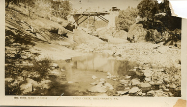
... in the early 1900s. This image is a representation of early automboile ...A postcard taken of Reid's Creek in Beechworth, taken in the early 1900s. This image is a representation of early automboile usage in the Beechworth area, with the car crossing the Reid's Creek bridge. Taken in Sepia tone it also has a detailed look of the foundations of the early bridge.Sepia rectangular photograph printed on matte photograph paperObverse The Rose Series P.10534 / Copyright Reid's Creek, Beechworth, Vic Reverse Left Side of Reverse: Published by the Rose Stereograph / Armadale, Victoria Top of Reverse: Post Card /Printed drawing of a rose The “Rose” Series / De Luxe A Real Photograph / Produced in Australia 1997.2607 Tanley Lower Right of Reverse: 2906 automobile, bridge, reid's creek, beechworth, postcard -
 The Beechworth Burke Museum
Photograph, c1960
The photograph depicts a view across the water at Lake Sambell. The image dates from approximately 1960. The present day park and reserve occupies the site of the former Rocky Mountain Mining Company, an open-cut sluice mine that began operations in the mid-Nineteenth Century and operated until the early 1900s, through the peak of Victoria’s Gold Rush. It was converted into a park and leisure area in the 1920s. Lake Sambell was formally opened to the public on Friday 5th October 1928 and was opened by the Victorian Government’s Minister of Lands, Mr Bailey, as part of initiatives to boost the economies and development of country towns. The lake was named after Mr L.H. Sambell, a shire engineer and secretary of the Forward Beechworth Committee who was involved in promoting the transformation of the mining site and promoting plantation forestry and tourism as alternative industries. £300 to begin the process was provided by Mr J. McConvill, a former resident of Beechworth, who is remembered in a street name adjacent to the lake. Residents of Beechworth have worked to raise funds to improve the Lake Sambell reserve several times, such as efforts in the 1930s and 1940s to raise the banks several feet to deepen the water for swimming purposes. Fundraising campaigns include the ‘Ugly Man’ competition conducted on behalf of the Wallace Park-Lake Sambell Development Scheme. The latter competition was run by the Fire Brigade Bend’s team as part of a larger competition called the ‘Mile of Pennies’; it was won by Mr Len Knight of Beechworth’s Commercial Hotel. The ‘Mile of Pennies’ was conducted at a Carnival held on New Year’s Eve, 1947. It was proposed by the Beechworth and District Progress Association. As well as improving swimming facilities, funds were raised to install a caravan park facility near the lake. Funds were also donated by commercial entities, such as £250 received from Zwar Bros. Pty Ltd. The photograph is significant as it shows the level of development of Beechworth in the early to mid-Twentieth Century. Sepia rectangular photograph printed on matte photographic paperObverse: nil. Reverse: 3470 / Velox (paper mark)beechworth, beechworth lake, lake sambell, lake, beechworth and district progress association, forward beechworth committee, ugly man, mile of pennies, wallace park lake sambell development scheme, wallace park-lake sambell development scheme, zwar bros, zwar, l.h. sambell, j. mcconvill, minister of lands, commercial hotel, len knight, rocky mountain mining company, rocky mountain mining co, gold rush, redevelopment, transformation, community fundraising