Showing 5415 items
matching eltham road district
-
 Eltham District Historical Society Inc
Book, A Review and Appraisal of the Diamond Creek to Ringwood Study, volume 2, working paper, by Loder and Bayly, November 1979, 1979
Review and appraisal of proposed extension of ring road91 p, maps, 27 cm.melbourne ring road -
 Eltham District Historical Society Inc
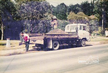
Photograph, Road Maintenance
One of a set of display images thought to be produced by the Shire of Eltham c.1979-1987. Council worker filling a pot hole on the side of a road with gravel from the back of a truck. There is a fire hydrant close by. Exact street location unknown.Illustrative of services provided by former Shire of ElthamColour photograph 20 x 29 cm mounted on green-painted chipboard 28 x 35.5 cm (string on back for hanging)Title printed on label adhered to board below photograph (replaced June 2017)road maintenance -
 Eltham District Historical Society Inc
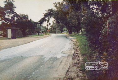
Photograph, Eltham-Yarra Glen Road, Reynolds Road to Kanandah Court
One of a set of display images thought to be produced by the Shire of Eltham c.1979-1987Illustrative of services provided by former Shire of ElthamColour photograph 20 x 29 cm mounted on green-painted chipboard 28 x 35.5 cm (string on back for hanging)Title printed on label adhered to board below photograph (replaced June 2017)road, eltham -
 Eltham District Historical Society Inc
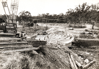
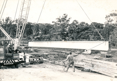
Photograph, Construction of new bridge over the Plenty River, Main Road, Lower Plenty, c.Aug. 1966
Construction of the Main Road bridge over the Plenty River. Includes structural members, construction personnel, vehicles and a Clarke mobile crane.Local significanceBlack and white printMarking on back of photograph - Plenty River Bridge Main Road 1969 (sic)lower plenty, main road, plenty river, bridge, bridge construction, civil engineering, cranes, mobile cranes -
 Eltham District Historical Society Inc
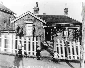
Photograph, Police House, Main Road Eltham, 1890s
Police Sergeant's family house, Police Station to right and Courthouse to left of house..Copy of black and white photograph of brick Police residence, 728 Main Road, Eltham, cnr. Brougham Street. Photograph includes 3 young children in front of fence. Circa 1890s police residence, police station, courthouse, eltham, main road, houses -
 Eltham District Historical Society Inc
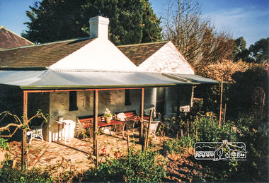
Brochure, 'Illilawa', Research
Timber Cottage circa 1881 at 35 Ingrams Road, Research.Printed Real Estate brochure of 'Illilawa', Ingrams Road, Kangaroo Ground featuring pretty stucco and timber cottage, bay windows, open fireplaces, loads of charm and character.houses, research, illilawa, ingrams road -
 Eltham District Historical Society Inc
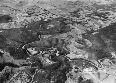
Photograph, Aerial view of Yarra River near Kangaroo Ground - Bend of Islands area
Sepia aerial view of Yarra river at Bend of Islands; Henley Road on left in foregroundbend of isles, kangaroo ground, yarra river, henley road -
 Eltham District Historical Society Inc
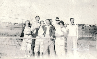
Photograph, Montmorency Tennis Club, c.1941, 1941c
Thomas John Kent (b. 1/9/18, d. 13/3/1998) married Florence Janet Hughes (b. 5/1/1921, d. 24/3/2011) on 15/11/1941. In the 1943 Electoral Roll they were recorded living at Watson St, McLeod and in 1949 at Mt. View Road, Montmorency. (Information gathered from Ancestry.com sources). Based on this data, the date of this photograph is estimated to be c. 1941 not 1927 as originally noted, which was the date that the Montmorency Tennis Club was established.Black & white photograph of eight individuals from Montmorency Tennis Club including Jack and Florrie Kent, c.1941"Montmorency Tennis Club c.1927 Jack Kent Florrie Kenttennis club, jack kent, montmorency, florrie kent -
 Eltham District Historical Society Inc
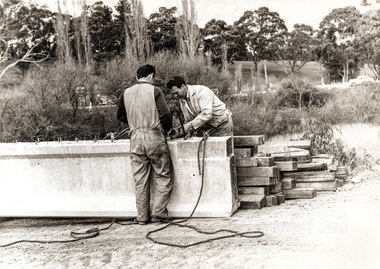
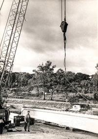
Photograph, Construction of Lower Plenty Bridge, Main Road, c.August 1966, 1966
Black and white photograph of crane lowering concrete girder into placeplenty river, bridge construction, main road, lower plenty, bridges -
 Eltham District Historical Society Inc
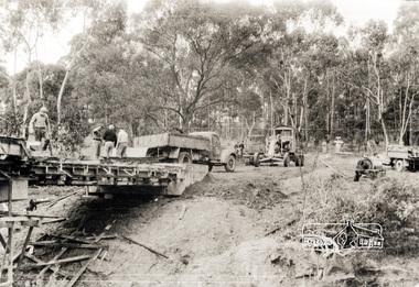
Photograph, Construction of Lower Plenty Bridge, Main Road, c.August 1966, 1966
Black and white photograph of construction of new bridge, Main Road, Lower Plentybridge construction, main road, lower plenty, plenty river, bridges -
 Eltham District Historical Society Inc
Photograph, Oxley Bridge construction, Henley Road, Kangaroo Ground, 1962
This is copy of a photograph taken 1962, during the construction of Oxley Bridge at Kangaroo GroundBlack and white photograph of Oxley Bridge construction over Watsons Creek, Henley Road, Kangaroo Ground, circa Aug-Sep 1962kangaroo ground, oxley bridge, watsons creek, henley road, bridges -
 Eltham District Historical Society Inc
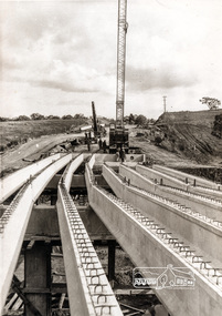
Photograph, Construction of Lower Plenty Bridge, Main Road, c.August 1966, 1966
This black and white photograph records construction activity of the then new Main Road bridge over the Plenty River at Lower Plenty in 1969.Local significanceBlack and white photograph taken during construction of the Main Road bridge over the Plenty River. Includes structural members, construction personnel, vehicles and a Clarke mobile crane.mobile cranes, bridge construction, main road, plenty river, lower plenty, bridges -
 Eltham District Historical Society Inc
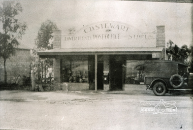
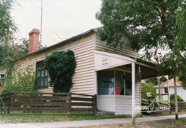
Photograph, Lower Plenty Post Office and store
Black and white photograph of early view of old Lower Plenty Post Office and storelower plenty, post office, shops, main road -
 Eltham District Historical Society Inc
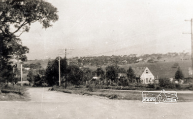
Photograph, Main Road, Lower Plenty
Black and white photograph of Main Road, Lower Plenty looking west from Old Eltham Roadlower plenty, main road, old eltham road -
 Eltham District Historical Society Inc
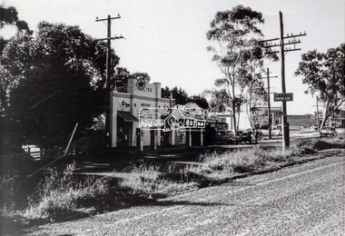
Photograph, Main Road, Lower Plenty at intersection of Old Eltham Road
View looking north across the main road towards the Lower Plenty shops showing the Lower Plenty Garage and store which was later developed into a Caltex service station, since demolished and replaced by a new Aldi supermarket.Black and white print Roll of 35mm colour negative film, 5 of 7 strips Kodak CP100 5094 and associated print Roll of 35mm black and white negative film, 3 strips Ilford FP4 and associated print Roll of 35mm colour negative film, 2 strips Kodak CP100 5094 and associated printaldi, caltex service station, lower plenty, lower plenty garage, lower plenty shops, main road, old eltham road, shops -
 Eltham District Historical Society Inc
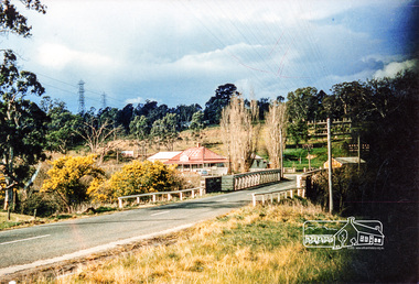
Photograph, Old Lower Plenty Bridge and Hotel
Colour photograph of Lower Plenty Bridge from the west prior to opening of new bridge. Hotel in background. 4 x 6 print and also laminated 8 x 10 print.lower plenty, main road, plenty river, golf club hotel, hotels, bridges -
 Eltham District Historical Society Inc
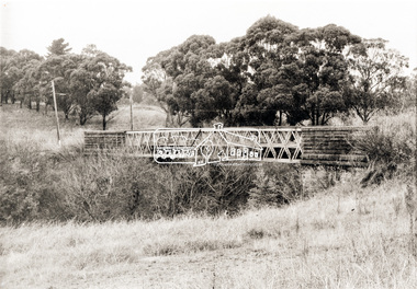
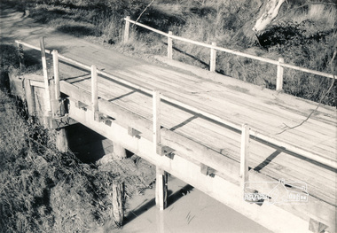
Photograph, Old Lower Plenty Bridge, c.1970
Old bridge across the Plenty River at Lower Plenty now part of the Plenty River Trail. Part of a slide show presentation "Bridges & Waterways of the Shire" by Russell Yeoman to the 13 September 1989 Society meeting. The presentation included slides of historic photos from the Shire of Eltham Pioneers collections as well as several recent views.Black and white photographmain road, plenty river, bridge, lower plenty, plenty river trail -
 Eltham District Historical Society Inc
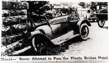
Photograph, Moral - "Never attempt to pass the Plenty Bridge Hotel"
Black and white photograph of a newspaper story about an accident at Lower Plenty Bridgelower plenty, bridge, main road, lower plenty bridge, transport, automobile, accident -
 Eltham District Historical Society Inc
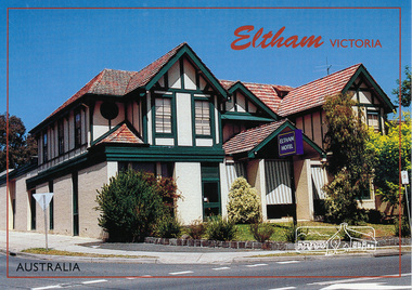
Postcard, McKenzie Photography, Eltham Hotel, Eltham, Victoria, Australia, 2015c
Postcard of Eltham Hotel, cnr Main Road and Pitt Street viewed from Main Road looking towards Pitt Street. Mel: 21 J7eltham-hotel, main-road, pitt-street, eltham -
 Eltham District Historical Society Inc
Photograph, Shop, Main Road, Hurstbridge
Colour photograph of a weatherboard shopshops, hurstbridge, kinglake road -
 Eltham District Historical Society Inc
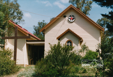
Photograph, Uniting Church, Main Road, Hurstbridge
Colour photograph, front view of Uniting Churchchurches, hurstbridge, kinglake road -
 Eltham District Historical Society Inc
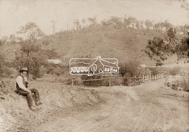
Photograph, Mr Belot smokes his pipe whilst resting at Cottle's Bridge, c.1890
The area, previously known as Back Creek, was named after Thomas Cottle, who settled in the district in the 1870s, and the original bridge over the Diamond Creek on the road to Strathewen. The original bridge (seen in the photo) was replaced with a new timber bridge at a cost of £1,500, the tender being awarded to a contractor named Birch who commenced work in June 1927. The gentleman in the photo who is resting whilst having a smoke of his pipe is a member of the Belot family.Original sepia photograph mounted on card broken lower left corner and cracked upper rightbelot, bridge, cottles bridge, cottles bridge-strathewan road, diamond creek (creek), heidelberg-kinglake road -
 Eltham District Historical Society Inc
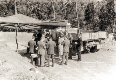
Photograph, Country Road Board members having morning tea just south of St Andrews, Heidelberg-Kinglake Road, 1962
Black and white photograph of Council and Country Road Board group with truckheidelberg kinglake road, kinglake road -
 Eltham District Historical Society Inc
Photograph, Russell Yeoman, Wilson Road Bridge, Wattle Glen, c.1970, 1970c
Black and white photograph Cross Ref: 00050 (print) and 01897-25 (negative)bridges, bridge, wattle glen, wilson road -
 Eltham District Historical Society Inc
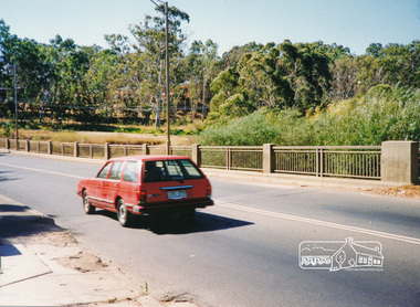
Photograph, Main Road Bridge, Lower Plenty
Colour photographbridges, lower plenty, main road, plenty river -
 Eltham District Historical Society Inc
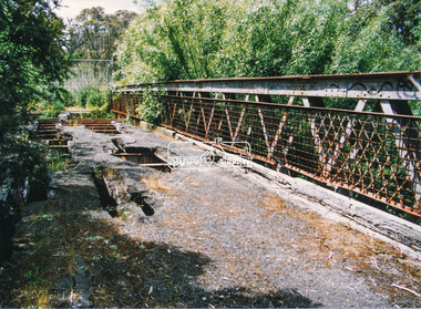
Photograph, Doug Orford, Lower Plenty Bridge, Old Eltham Road, Lower Plenty, 1998
Originally the boundary between the former Shire of Eltham and the City of Heidelberg, a toll gate existed on the Eltham side. The bridge has since been restored and is now part of the Plenty River Trail.Two colour photograph prints 10 x 15 cm (2 copies)bridges, lower plenty, main road, plenty river, old eltham road -
 Eltham District Historical Society Inc
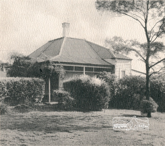
Photograph, House, 'Rosehill', Lower Plenty, 1968
Three black and white photographs of views of 'Rosehill' at Lower Plenty, 1968rosehill, bonds road, lower plenty, houses, henry stooke -
 Eltham District Historical Society Inc
Photograph, House, 'Rosehill', Lower Plenty
Colour photograph of rear view of 'Rosehill' showing verandahrosehill, lower plenty, bonds road, houses, henry stooke -
 Eltham District Historical Society Inc
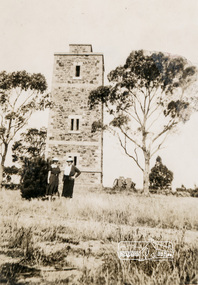
Photograph, Shire of Eltham War Memorial, Memorial Park, Garden Hill, Eltham-Yarra Glen Road, Kangaroo Ground, c.1936, 1936c
On November 11th 1926 the Shire of Eltham War Memorial Tower at Kangaroo Ground was opened. It is regarded as one of Melbourne’s most outstanding lookout towers. It commands a magnificent 360 degree panorama from Kinglake across the Diamond Valley to Macedon and the You Yangs. It is built on a peak which was once a volcano, 237 metres above sea level. After World War one a memorial cairn was erected on the site, and in 1925 a committee of public-minded citizens began to plan for a tower. Many generous donations of material and money were forthcoming so that in 1926 the Governor General Lord Stonehaven was able to unveil the plaque before a crowd of 500 people There was some concern in the 1960s when the Forests Commission wanted to build a firespotters cabin on the top. At first R.S.L. branches opposed the idea, but it was realised that this use could combine with its use as a tourist attraction, and would ensure its maintenance for the future. Today the Kangaroo Ground tower provides one of the best views around Melbourne and is a fitting memorial to those who died in two world wars. From: Historic items for Diamond Valley Community Radio September 1990 (EDHS collection) On November 8th, 1951, the memorial was re-dedicated by the Governor of Victoria, Sir Dallas Brooks with the addition of the names of men from the Shire of Eltham who fell in the Second World War. Further wreaths were added subsequent to this image in time for the 2001 Reembrance Day service to commemorate the men from th shire who had fallen in the Malayan, Korean, Borneo and Vietnam campaigns. Sepia photograph showing two ladies standing in front of the towergarden hill, kangaroo ground, kangaroo ground memorial, memorial park, shire of eltham war memorial tower, war memorial