Showing 183 items
matching exploration australia
-
 Merri-bek City Council
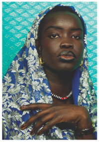
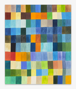
Photograph - Ilford smooth pearl print, Atong Atem, Nyanluak, 2022
-
 Merri-bek City Council
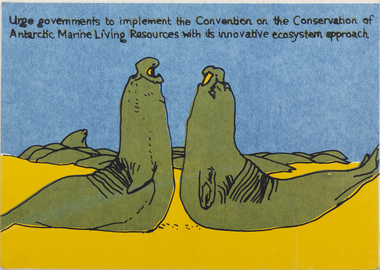
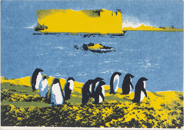
Work on paper - Screen print, Wendy Black, Declare Antarctica a World Park - Weddell Seals, 1982
The 1980s saw a rise in campaigns for Antarctica to be designated a World Park. Black’s screenprints celebrate the creatures of the continent, however invocations such as ‘protect Antarctica from all mineral and oil exploration and exploitation’ remind the viewer that these creatures are in peril. Black printed 500 of these postcards (described as ‘Antarcticards’) at the Redletter Press in Brunswick and they were distributed around the world, reaching as far as Macquarie and Heard Islands. The campaigning was successful, with Australian Prime Minister Bob Hawke announcing that Australia would not support an agreement that would open the Australian Antarctic Territory up to mining and oil drilling.Donated by the artist8 prints in total -
 Merri-bek City Council
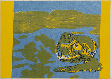
Work on paper - Screen print, Wendy Black, Declare Antarctica a World Park - Elephant Seal, 1982
The 1980s saw a rise in campaigns for Antarctica to be designated a World Park. Black’s screenprints celebrate the creatures of the continent, however invocations such as ‘protect Antarctica from all mineral and oil exploration and exploitation’ remind the viewer that these creatures are in peril. Black printed 500 of these postcards (described as ‘Antarcticards’) at the Redletter Press in Brunswick and they were distributed around the world, reaching as far as Macquarie and Heard Islands. The campaigning was successful, with Australian Prime Minister Bob Hawke announcing that Australia would not support an agreement that would open the Australian Antarctic Territory up to mining and oil drilling.Donated by the artist8 prints in total -
 Merri-bek City Council
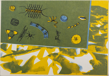
Work on paper - Screen print, Wendy Black, Declare Antarctica a World Park - Phytoplankton, 1982
The 1980s saw a rise in campaigns for Antarctica to be designated a World Park. Black’s screenprints celebrate the creatures of the continent, however invocations such as ‘protect Antarctica from all mineral and oil exploration and exploitation’ remind the viewer that these creatures are in peril. Black printed 500 of these postcards (described as ‘Antarcticards’) at the Redletter Press in Brunswick and they were distributed around the world, reaching as far as Macquarie and Heard Islands. The campaigning was successful, with Australian Prime Minister Bob Hawke announcing that Australia would not support an agreement that would open the Australian Antarctic Territory up to mining and oil drilling.Donated by the artist8 prints in total -
 Merri-bek City Council
Work on paper - Screen print, Wendy Black, Declare Antarctica a World Park - Squid (1982), 1982
The 1980s saw a rise in campaigns for Antarctica to be designated a World Park. Black’s screenprints celebrate the creatures of the continent, however invocations such as ‘protect Antarctica from all mineral and oil exploration and exploitation’ remind the viewer that these creatures are in peril. Black printed 500 of these postcards (described as ‘Antarcticards’) at the Redletter Press in Brunswick and they were distributed around the world, reaching as far as Macquarie and Heard Islands. The campaigning was successful, with Australian Prime Minister Bob Hawke announcing that Australia would not support an agreement that would open the Australian Antarctic Territory up to mining and oil drilling.Donated by the artist8 prints in total -
 Merri-bek City Council
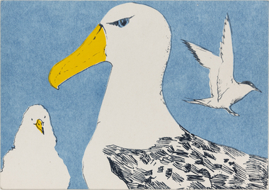
Work on paper - Screen print, Wendy Black, Declare Antarctica a World Park - Tern, 1982
The 1980s saw a rise in campaigns for Antarctica to be designated a World Park. Black’s screenprints celebrate the creatures of the continent, however invocations such as ‘protect Antarctica from all mineral and oil exploration and exploitation’ remind the viewer that these creatures are in peril. Black printed 500 of these postcards (described as ‘Antarcticards’) at the Redletter Press in Brunswick and they were distributed around the world, reaching as far as Macquarie and Heard Islands. The campaigning was successful, with Australian Prime Minister Bob Hawke announcing that Australia would not support an agreement that would open the Australian Antarctic Territory up to mining and oil drilling.Donated by the artist8 prints in total -
 Merri-bek City Council
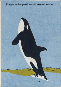
Work on paper - Screen print, Wendy Black, Declare Antarctica a World Park - Whale, 1982
The 1980s saw a rise in campaigns for Antarctica to be designated a World Park. Black’s screenprints celebrate the creatures of the continent, however invocations such as ‘protect Antarctica from all mineral and oil exploration and exploitation’ remind the viewer that these creatures are in peril. Black printed 500 of these postcards (described as ‘Antarcticards’) at the Redletter Press in Brunswick and they were distributed around the world, reaching as far as Macquarie and Heard Islands. The campaigning was successful, with Australian Prime Minister Bob Hawke announcing that Australia would not support an agreement that would open the Australian Antarctic Territory up to mining and oil drilling.Donated by the artist8 prints in total -
 Warrnambool and District Historical Society Inc.
Memorabilia (Collection) - Des Williams' Collection (Mahogany Ship Research Material), Mahogany Ship Committee, Warrnambool, Des Williams Collection, early 21st century
... the early exploration history of eastern Australia) mahogany ship ...Material originally collected by Warrnambool Mahogany Ship CommitteeMaterial collected for research and commemorative purposesA3 archival box containing folders of paper materialMahogany Ship material and other memorabilia of Des Williamsmahogany ship, joseph archibald, des williamsmahogany ship, joseph archibald, des williams -
 Warrnambool and District Historical Society Inc.
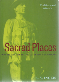
Book, Kenneth Stanley Inglis, Sacred Places War Memorials in the Australian Landscape
... . The book has relevance to all Australians as an exploration ...This book looks at the war memorials in Australia and traces the development of the Anzac cult and the reasons that the war memorials are increasingly cherished in Australian society. It is an important treatise on a unique aspect of Australia cultural life.This is a paperback book of 521 pages. The cover is multi-coloured with an image of an Australian soldier on the front and spine.non-fictionThis book looks at the war memorials in Australia and traces the development of the Anzac cult and the reasons that the war memorials are increasingly cherished in Australian society. It is an important treatise on a unique aspect of Australia cultural life.war memorials in australia, monuments -
 City of Moorabbin Historical Society (Operating the Box Cottage Museum)
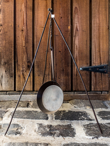
Functional object - Kitchen Equipment, billy holder, c1880
A billycan, is a lightweight cooking pot which is used on a campfire or a camping stove, particularly associated with Australian usage, but is also used in the UK and Ireland. It is widely accepted that the term "billycan" is derived from the large cans used for transporting bouilli or bully beef on Australia-bound ships or during exploration of the outback, which after use were modified for boiling water over a fire. However there is a suggestion that the word may be associated with the Aboriginal billa (meaning water; cf. Billabong In Australia. The billy has come to symbolise the spirit of exploration of the outback. To boil the billy most often means to make tea. "Billy Tea" is the name of a popular brand of tea long sold in Australian grocers and supermarkets. Billies feature in many of Henry Lawson's stories and poems. Banjo Paterson's most famous of many references to the billy is surely in the first verse and chorus of Waltzing Matilda: "And he sang as he looked at the old billy boiling", which was later changed by the Billy Tea Company to "And he sang as he watched and waited 'til his billy boiled”. Early settlers , market gardeners and blacksmiths would use this portable iron stake to hold their Billies at meal times when out working their fields, travelling for work or pleasure.c1880 A molded, iron tripod stake that would hold a 'Billy can' of water over a camp or kitchen fireearly settlers, pioneers, market gardeners, moorabbin, bentleigh, brighton, cheltenham, tools, blacksmiths -
 Merri-bek City Council
Photograph - Digital print on Ilford Fibre Pearl paper, Kim Kruger, Within ten miles of Melbourne 2, 2022
-
 Merri-bek City Council
Photograph - Digital print on Ilford Fibre Pearl paper, Kim Kruger, Splitting logs for a “feed” 1, 2022
-
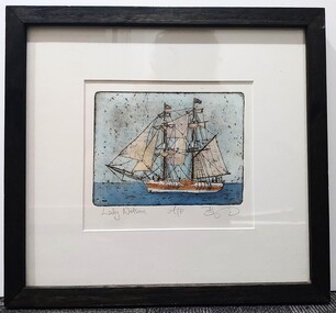 Glenelg Shire Council Cultural Collection
Artwork, other, BRIGIT THOMAS, Lady Nelson, c. 2015
From - theladynelson.org.au T The original Lady Nelson was built at Deptford, in England, in 1799, for service to the Transport Office on the River Thames. She was designed with sliding keels (centre boards), a device invented by Captain John Schank of the Royal Navy to allow surveying in rivers and shallow water ways. On completion she was selected for exploration services in the Colony of New South Wales and sailed for Port Jackson on 18 March 1800 under the command of Lieutenant James Grant. A brig of 60 tons, she carried a crew comprising the commander, two mates and twelve seaman. As she left the River Thames sailors on nearby ships ridiculed her because of her size and shape, calling her, as she sailed past, 'His Majesty's Tinderbox'. At Portsmouth on the 9th February 1800 she was fitted with four brass carriage guns, three to four pounders, in addition to the two guns already on board. Because of the heavy load she was carrying she was very low in the water, having only two feet nine inches freeboard amidships. The ship finally left Portsmouth on 17th March 1800 as part of an East Indian Convoy. From 1800 to 1825 the Lady Nelson operated around the Australian Coast and fulfilled a variety of roles including exploration, surveying, forming settlements, shifting goods and people around the colonies and capturing pirates. She played pivotal roles in the European settlement of Hobart, Northern Tasmania, Melbourne, Newcastle, Port Macquarie and Northern Territory. Those onboard charted much of Bass Strait, Port Philip, Newcastle, Port Macquarie and (with the Investigator) the coasts of northern New South Wales and southern Queensland. She also has links to other locations around the East Coast such as Trial Bay in NSW and the Mt Gambier area of SA. After 25 years of service while trading on the island of Baba the Lady Nelson was overrun by the islanders, the crew was killed and the ship stripped and later burnt and sunk. A replica of the Lady Nelson was built in the 1980s.Image of a tall ship in sail. The ship is flying both the Aboriginal flag and the Australian Flag. It sails on a calm sea. There are figures on the deck - four in total. The image is mounted on cream board and framed in dark timber. Etching, hand coloured,.Front: 'Lady Nelson A/P BT' - hand written, pencil in between etching and mount Back: Artist's business card glued to back of etching, lower left hand corner:ady nelson, femal artists, female artist, women -
Lakes Entrance Historical Society
Book, Loney, Jack, Maritime Australia - Short Tales of Ships and Men
Tales of ships and men upon the oceans around Australia, drawn from original records.purchased 17. 1.1985exploration, ships and shipping -
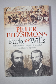 Warrnambool and District Historical Society Inc.
Book, McPherson’s Printing Group, Burke & Wills, 2017
... played a part in Warrnambool’s history. Australian Exploration ...This book gives a comprehensive and scholarly account of the ill-fated Burke and Wills expedition in Australia in 1860-1961. It is written by Peter Fitzsimons. The narrative includes the parts played in the expedition by two men who also had important connections to Warrnambool. One of these was Henry Foster who was Superintendent of Police in Swan Hill in the 1860s. In the early 1840s Henry Foster and Thomas Strong took up a run of 16.000 acres (St. Mary’s, Wangoom)). Their land was bounded on the south by the Southern Ocean, on the east by the Hopkins River, on the north by a fence from the Hopkins to the Merri Rivers and on the west by the Merri River and included the later surveyed site of the Warrnambool township. After Warrnambool was established Foster was able to retain 450 acres of the original run near Wangoom on the Hopkins River. He was active in Warrnambool’s early history, was a Justice of the Peace for the Belfast (Port Fairy) district in the late 1840s and his portrait is on the Warrnambool Pioneer Honour Board. The other local Warrnambool personality mentioned in the Burke and Wills book is Richard Bennett, in the 1860s, the manager of several large farming properties in N.S.W., including Canally Station on the Murrumbidgee where he came into contact with the expedition leaders. In the Warrnabool district Bennett was well-known from the 1870s to his death in 1904 as the proprietor of wool-scouring establishments on the Shaw River and at Dennington and as a public campaigner for local coal exploration, for artesian bore drilling and for numerous other projects, including the development of the local wool industry. His portrait is also on the Warrnambool Pioneer Honour Board. This book is retained as an account of an important event in Australia’s history and because it has several references to two men (Henry Foster and Richard Bennett) who also played a part in Warrnambool’s history. This is a hard cover book of 700 pages. The cover is black with gold printing on the spine and the dust cover has a cream background with light brown and black printing, black and white photographs and sepia-coloured sketches. The contents include a List of Maps, Dramatis Personae, Background and Acknowledgements, Prologue, 18 Chapters, Epilogue, Endnotes, Bibliography and Index. The pages contain maps, sketches and black and white and colour photographs. australian exploration, burke and wills expedition, richard bennett, warrnambool, henry foster, st. mary’s wangoom, history of warrnambool -
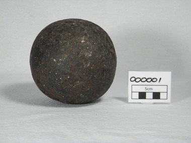 Warrnambool and District Historical Society Inc.
Weapon - Artefact, Cannon ball, pre 1830
This cannon ball formed the basis of a discussion with artillerist Peter Webster and historical society members in 2011. The following ideas were put forward. It was approximately 5 inches in diameter and weighed 10lb, Such cannon balls were used in an 18 calibre cannon, which were used only on ships. (12 calibre guns were field artillery). Australia was behind England in its artillery use and used hand me downs. In the 1800's Australia did an audit of artillery and cleared out those no longer in use. By the time of the 1830's 18lb cannons were largely obsolete and removed from service Australia used 18 calibre cannons in Northern Australia at Port Essington and Fort Dundas (Melville Island) Perhaps this cannon ball has no real connection with Australia and came as ballast from some other country.This is one of the more interesting items in our collection and there has been much conjecture over the years as to the story of how it ended up in Warrnambool. In that way it has built its own mystery and provenanceRound metal ball measuring 5 inches in diameter, weighing 10lb. The surface is pitted with the original surface visible in some parts.defence, war, ships, cannon ball, exploration, warrnambool, warrnambool history, warrnambool cannonball -
 Merri-bek City Council
Photograph - Digital print on Ilford Fibre Pearl paper, Kim Kruger, Within ten miles of Melbourne 1, 2022
merri-bek public art collection -
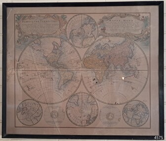 Flagstaff Hill Maritime Museum and Village
Map - World Map, Mappe Monde [Medieval Map of the World], 1910
This map from the mid-18th century doesn't include the finer details of land and sea masses that we know today. The map was produced by German cartographer and publisher, Johann Baptist Homann (1663-1724) and published in 1746, after his death. Earlier versions were published, such as 1707 and 1716. The date can be calculated from the Roman numerals on the top left text area. This print of a map is significant for its connection with early world explorers. A comparison of maps over the centuries shows the progression of navigational technology, the countries who claimed the land they explored. The naming of even some Australian locations shows who had already made their mark on Australia in the early 18th century. The print shows the fine details included by the cartographer and the beauty included that makes it attractive and interesting even today. The map is also significant for its connection with German cartographer, Johann Baptist Homann, whose Homann publishing company was renewed in Germany for producing high quality maps and atlases. Map behind glass in dark brown wooden frame on beige paper. The Coloured hand drawn line drawings show different hemispheres of the known world in the mid-18th century. Beautifully drawn figures and decorative embellishments enhance the map. The text on the top right has an explanation of the Figures I, II, III, and IV. This print of the 1746 map was produced in England by Leisure Arts Ltd. "PLANIGLOBIL TERRESTRIS" "MDCCXXXXVI" [1746] "MAPPE_MONDE" [Medieval Map of the World] "LEISURE ARTS LTD" "Printed in England"flagstaff hill, warrnambool, flagstaff hill maritime museum, flagstaff hill maritime village, flagstaff hill maritime museum and village, shipwreck coast, world map, french map, 18th century map, leisure arts ltd, cartography, early exploration, cartographer, johann homann (1663-1724), exploration, naviagtion, 1746 planiglobil terrestris -
Lakes Entrance Historical Society
Book, Enever, Jim, Journal of Australian Mining History Vol 8, 2010
A comprehensive report of the exploration and production of oil in the Lakes Entrance, East Gippsland basin, in particular the Lakes Entrance oil shaft.oil and gas industry, world war 1939 - 1945 -
 Federation University Art Collection
Artwork, other, 'Eel Trap with Emu Feathers' by Bronwyn Razem, 2013
"The breeze going through the eel trap gives a feeling of water flowing through the vessel with the feathers softly waiving as the water flows. My grandfather Nicholas Couzens and my uncles made eel traps to fish the Hopkins River - this is how my mother learnt the techniques which she passed on to me."Bronwyn RAZEM Gunditjmara/Kirrae Whurrong Bronwyn Razem is an Indigenous Australian basket weaver and painter. She is a Gunditjmara woman of the Kirrae Whurrong clan of western Warrnambool on the Victorian coastline. Bronwyn’s practice involves an exploration of her Indigenous heritage and identity, and she creates symbolic representations of places and events that are meaningful to her family. She integrates ochres, sand and other materials into her paintings, and her works also draw on the possum skin cloak traditions of her ancestors. In 2008, Bronwyn was chosen by the Australia Council for the Arts to be part of a delegation of Indigenous artists to attend the 10th Pacific Arts Festival in Western Samoa. Bronwyn’s mother, Aunty Zelda Couzens, was a well-respected basket weaver and elder who taught Bronwyn basket-making techniques. Bronwyn now regularly conducts basket weaving workshops with Victorian Indigenous communities in order to facilitate the revival of cultural traditions. She has a Bachelor of Arts with Honours at Deakin University, and in 2008 she was enrolled in a Master by Research degree at Deakin Institute of Koorie Education, Geelong, and was living in Ballarat. (https://www.daao.org.au/bio/bronwyn-razem/biography/, accessed 18 April 2016) This item is part of the Federation University Art Collection. The Art Collection features over 1000 works and was listed as a 'Ballarat Treasure' in 2007.Bronwyn RAZEM (1953- ) Gunditjmara/Kirraw Wurrong A woven New Zealand flax eel trap with emu feathers. This work won the University of Ballarat Acquisitive Award for work reflecting Victoria's Western District. The judges were impressed by Bronwyn Razem's translation of the traditional eel trap into a sculptural form evocative of the flow of water and possible the passage of time. The design and technical knowhow which Razem inherited from her mother, uncles, and grandfather connects this work to the family;s life and traditions. She then enhances the simplicity of this very functional object by the addition of delicate emu feathers, creating a work that creatively and symbolically transcends its original form. art, artwork, bronwyn razem, razem, eel trap, aboriginal, indigenous, available -
 Merri-bek City Council
Painting - Oil on linen, Renee Cosgrave, Learning Whakapapa (Māori Land Court Archives), 2023
-
 Bendigo Military Museum
Journal - Desert Exploration - Extract from Northern Territory Lands and Survey Dept Annual Report 1960-61, Northern Territory Lands and Survey Branch, 1961
This Extract from Northern Territory Lands and Survey Dept Annual Report 1960-61 is about Desert Exploration between Wave Hill and Tennant Creek. The 2 x fold out maps are 1:1,000,000 scale with one showing a Levelling Traverse. The exploration took place during March and April 1960. This document has been included in the RASvy collection because it was valuable information that was needed by RASvy surveyors who were required to operate in the area in later years.5 x foolscap sized pages and 2 x map foldout pages held together with a slide clip. Pages and maps are two hole punchedroyal australian survey corps, rasvy, fortuna, army survey regiment, army svy regt, asr -
Lakes Entrance Historical Society
Book, Child and Henry In association with Fine Arts Press edited by E E Morris, Australia First Century, 1978
A facsimile edition of pages devoted to Australia appearing in Cassells Picturesque Australia Victoriahistory, exploration, mines and mining, agriculture -
 Glenelg Shire Council Cultural Collection
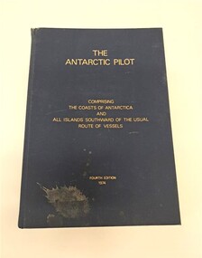
Book, Hydrographer of the Navy, The Antarctic Pilot, 1974
A reference book detailing the coast and islands of AntarcticaNavy blue hardback book. Gold lettering on the front cover and spine. There is a splash of dirt on the bottom lefthand corner of the front cover. The top of the spine is slightly ripped. It describes the coasts of Antarctica and surrounding islands.non-fictionA reference book detailing the coast and islands of Antarcticanaval, navigation, maritime, nautical, antarctica, portland, glenelg, glenelg shire, vessel, research -
 Victorian Railway History Library
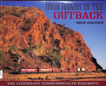
Book, Nick Anchen, Iron Roads in the Outback, 2017
The Iron Roads of the Australian Outback - the legendary Commonwealth Railways were built through some of the harshest landscapes on Earth. They were railways like no other, where men and women battled extreme temperatures, flash floods and maddening isolation to keep the trains running. This publication is the culmination of 25 years of Outback exploration, research, photography and interviews by author Nick Anchen. The result is a diverse book which brings to life both the beauty and harshness of the Australian Outback, through a collection of fascinating and historic images, along with the memories of former Commonwealth Railways employees. Following an introductory chapter on the vastness and grandeur of the Australian interior - highlighted by the memoirs of 1950s flying doctor Macarthur Job - the book delves into the story of the Central Australia Railway. This was the line built through the 'back of beyond' - the forbidding desert country of South Australia and the Northern Territory. It was here that operators of famous trains such as The Ghan battled searing heat, dust storms and raging floodwaters to keep the trains running. The chapter includes stories by well known Ghan conductor 'Aspro' Lyons, and 'Piano Playing Chef' Paddy Greenfield - along with enginemen Wolf Markowski and John Theel, both of whom worked trains on this famous railway. The story of the North Australia Railway - 'The Line to Nowhere' - is the tale of a ramshackle railway which came alive during the dark days of World War II. The memoirs of wartime engineman Jim Prentice are eye opening, as are the hair raising accounts of surviving Tropical Cyclone Tracy, as told by rolling stock foreman Bill Donaldson. The Trans-Australian Railway was built across one of the harshest and loneliest environments on Earth - the vast Nullarbor Plain. Stories from enginemen Jack Slattery and Ron Howrie, along with Nullarbor resident and roadmaster's wife Cathy Beek, tell not only of the rudimentary living conditions and maddening isolation, but of the great camaraderie amongst the railway people who kept trains such as the Trans-Australian and the Tea and Sugar running. As well as examining the ruins and relics from the long-closed CR narrow gauge lines, the book also includes a chapter on the much-loved Pichi Richi Railway - the last surviving portion of that great Transcontinental Railway dream from another age.ill, maps, p.208.non-fictionThe Iron Roads of the Australian Outback - the legendary Commonwealth Railways were built through some of the harshest landscapes on Earth. They were railways like no other, where men and women battled extreme temperatures, flash floods and maddening isolation to keep the trains running. This publication is the culmination of 25 years of Outback exploration, research, photography and interviews by author Nick Anchen. The result is a diverse book which brings to life both the beauty and harshness of the Australian Outback, through a collection of fascinating and historic images, along with the memories of former Commonwealth Railways employees. Following an introductory chapter on the vastness and grandeur of the Australian interior - highlighted by the memoirs of 1950s flying doctor Macarthur Job - the book delves into the story of the Central Australia Railway. This was the line built through the 'back of beyond' - the forbidding desert country of South Australia and the Northern Territory. It was here that operators of famous trains such as The Ghan battled searing heat, dust storms and raging floodwaters to keep the trains running. The chapter includes stories by well known Ghan conductor 'Aspro' Lyons, and 'Piano Playing Chef' Paddy Greenfield - along with enginemen Wolf Markowski and John Theel, both of whom worked trains on this famous railway. The story of the North Australia Railway - 'The Line to Nowhere' - is the tale of a ramshackle railway which came alive during the dark days of World War II. The memoirs of wartime engineman Jim Prentice are eye opening, as are the hair raising accounts of surviving Tropical Cyclone Tracy, as told by rolling stock foreman Bill Donaldson. The Trans-Australian Railway was built across one of the harshest and loneliest environments on Earth - the vast Nullarbor Plain. Stories from enginemen Jack Slattery and Ron Howrie, along with Nullarbor resident and roadmaster's wife Cathy Beek, tell not only of the rudimentary living conditions and maddening isolation, but of the great camaraderie amongst the railway people who kept trains such as the Trans-Australian and the Tea and Sugar running. As well as examining the ruins and relics from the long-closed CR narrow gauge lines, the book also includes a chapter on the much-loved Pichi Richi Railway - the last surviving portion of that great Transcontinental Railway dream from another age. commonwealth railways (australia) -- history., central australia railway -- history. -
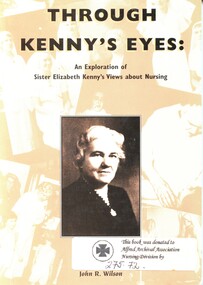 Alfred Hospital Nurses League - Nursing Archive
Book - Illustrated book, John Robert Wilson 1951, Through Kenny's eyes: an exploration of Sister Elizabeth Kenny's views about nursing, 1995
The book examines how Elizabeth Kenny's, which often went against medical wisdom, significantly impacted the treatment of polio and influenced the development of physical therapy and rehabilitation. Previously the standard treatment for polio had been immobilization.Book has a black and white photograph of a woman in a dark coloured dress (Elizabeth Kenny [ca.1942]) Title and author's name are printed on a background of assorted sepia photos of nurses and patients. Abbreviated title and the authors name are also printed in light brown on a black background on the spine. A summary of the book is printed on the back covernon-fictionThe book examines how Elizabeth Kenny's, which often went against medical wisdom, significantly impacted the treatment of polio and influenced the development of physical therapy and rehabilitation. Previously the standard treatment for polio had been immobilization.elizabeth kenny 1886-1952, nursing-philosophy, nursing-research-philosophy, poliomylitis -
 Buninyong Visitor Information Centre
Book, Australian Pioneers, 1975
Biographical details of settlers and explorers after Europeans arrived in Australia.Yellow fabric covered hardcover with printed slip cover featuring an ST Gill print of miners heading to the the diggings.non-fictionBiographical details of settlers and explorers after Europeans arrived in Australia. pioneers, exploration, settlements -
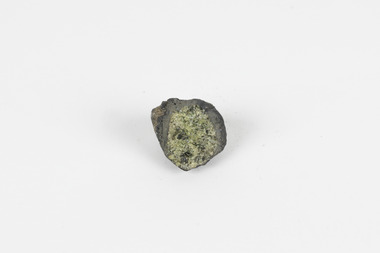 The Beechworth Burke Museum
Geological specimen - Olivine with Chromian diopside (dark green), Unknown
This specimen was donated in 1868 by Alfred Selwyn. Olivine is typically found in basic and ultra-basic igneous rocks around the world, in a variety of colours including yellowish green, olive green, greenish black and reddish brown with a transparent to translucent diaphaneity. The luster of the specimen is vitreous, the luminescence non-fluorescent and when fractured the mineral is very brittle producing small, conchoidal fragments. Chromian diopside is normally found in small sizes as the larger the size of the mineral the darker the colour is, almost black rather than green. Chromium is the element that gives chromian diopside and emeralds their rich green colour. Diopside is found across the world in multiple colours however gem-quality chromian diopside is mined in Siberia, Russia and prominent within the jewellery industry as a more affordable substitute to emeralds. Chromium-bearing diopside has been located across Australia. Chromium-bearing Diopside is located across the world found in North America, parts of South America, and across Australia, Africa, Europe and Asia. Chromium-bearing Diopside is mined in Siberia, Russia and is sold as a commercial substitute for emeralds. The stone is often turned into jewellery. This item is one of many geological and mineral specimens that constitute a broader collection obtained from various regions across Australia (as well as some international locales) and generously contributed to the Burke Museum between 1868 and 1880. A significant portion of these specimens originated from Victoria and were acquired as a result of the Geological Survey of Victoria, initiated in 1852 during the Gold Rush era. The primary objective of this survey was to investigate and chart the geological characteristics of Victoria. The procurement of geological specimens played a vital role in advancing our comprehension of the Earth's scientific composition and was instrumental in supporting research and educational institutions throughout Australia, including the Burke Museum, in their efforts to foster further exploration and study. A solid mineral specimen in shades of green, grey and brownburke museum, beechworth, geological, geological specimen -
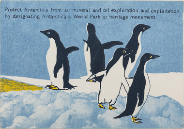
 Merri-bek City Council
Work on paper - Screen print, Wendy Black, Declare Antarctica a World Park - Penguin, 1982
The 1980s saw a rise in campaigns for Antarctica to be designated a World Park. Black’s screenprints celebrate the creatures of the continent, however invocations such as ‘protect Antarctica from all mineral and oil exploration and exploitation’ remind the viewer that these creatures are in peril. Black printed 500 of these postcards (described as ‘Antarcticards’) at the Redletter Press in Brunswick and they were distributed around the world, reaching as far as Macquarie and Heard Islands. The campaigning was successful, with Australian Prime Minister Bob Hawke announcing that Australia would not support an agreement that would open the Australian Antarctic Territory up to mining and oil drilling.Donated by the artist8 prints in total -
 Merri-bek City Council
Work on paper - Screen print, Wendy Black, Declare Antarctica a World Park - Adelie, 1982
The 1980s saw a rise in campaigns for Antarctica to be designated a World Park. Black’s screenprints celebrate the creatures of the continent, however invocations such as ‘protect Antarctica from all mineral and oil exploration and exploitation’ remind the viewer that these creatures are in peril. Black printed 500 of these postcards (described as ‘Antarcticards’) at the Redletter Press in Brunswick and they were distributed around the world, reaching as far as Macquarie and Heard Islands. The campaigning was successful, with Australian Prime Minister Bob Hawke announcing that Australia would not support an agreement that would open the Australian Antarctic Territory up to mining and oil drilling.Donated by the artist8 prints in total