Showing 277 items
matching extreme%20weather%20events
-
 Hume City Civic Collection
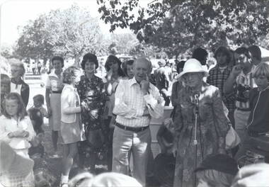
Photograph, Sunbury Fair c 1977, c1977
The photograph was taken at the Sunbury Fair possibly in 1977 when Bert Kelly, who is the man in the foreground, was the Shire President. Every year in March the Shire of Bulla held the fair in which community groups participated in a parade in the morning and the afternoon was given over to entertainment by local groups and displays on the Village Green. The lady, wearing a dark patterned dress and standing immediately behind Bert Kelly is Shirley McKerrow. Mrs Mommsen is standing next to him and the young man 2nd from extreme right is Graham Gibb. Her husband, Frederick Christian Mommsen was a former Shire of Bulla councillor.The Sunbury Fair was a popular annual event that took place in Sunbury and allowed local groups to participate.A black and white photograph with rounded corners of a group of people in a parkland. gathered around an elderly lady and a man. bert kelly, sunbury fair, village green, shirley mckerrow., graham gibb, mrs. mommsen -
 Bendigo Historical Society Inc.
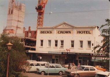
Photograph - BENDIGO HOTEL COLLECTION: BECK'S CROWN HOTEL, HARGREAVES STREET, BENDIGO
Colour photograph: Beck's Crown Hotel, Hargreaves Street, Bendigo. Image shows two storey hotel, white painted, brown writing 'Beck's Crown Hotel' on top storey façade. Simple pediment on top of hotel. Cars parked at parking meters in Hargreaves Street. Cantilever verandah in front of hotel. VACC Insurance Col Ltd., and Beck Sheahan & Co. names on verandah. Extreme RH side, Robbs. Large crane in LH background, behind Shamrock Hotel. Construction of multi-storey carpark visible on LH side, fronting Hargreaves Street. Early 1980's ?.bendigo, hotel, beck's crown hotel -
 Federation University Art Collection
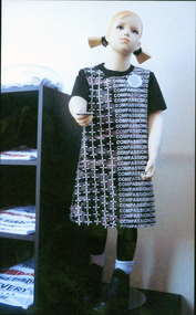
Sculpture, Frances Deutsher, 'make COMPASSION the fashion' by Frances Deutsher, 2015
Artist's Statement: The conflict of 1914 -1918 was dubbed ‘the war to end all wars’. In contradiction to the Kellogg-Briand Pact of 1928 for ‘renunciation of war’, the twentieth century can be viewed as the bloodiest in history with no fewer than 59 conflicts occurring globally. My work honours the innocents, the children of war, who have experienced loss and grief in its extreme; who have witnessed slaughter on a scale I cannot imagine. The work asks that we, the privileged and scar free, embrace the imperative for Peace…putting our money where our mouth is…promoting COMPASSION as the fashion EVERY year. Please take a badge frances deutsher, lucato peace prize, sculpture, fashion -
 City of Ballarat Libraries
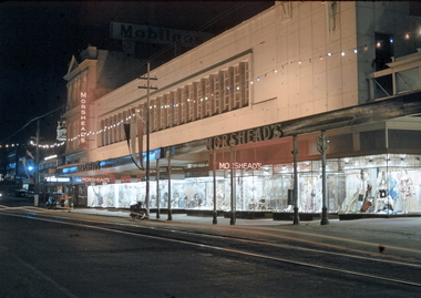
35mm Slide, Morshead's Department Store, Bridge Street Ballarat, circa 1950s
Morshead's was a popular department store in the 1950s and 1960s. In this night exposure the famous window displays can be clearly seen. Also at the extreme right of the photograph the verandah over 'the bridge' can be seen - the creek is covered over making an arcade. Also the verandah posts which were all removed in the 1960s and cantilevered verandahs installed throughout Ballarat. Mrs Bon Strange and her husband Bert were well known Ballarat residents. When Mrs Strange died some years ago, her extensive slide collection was sorted through and those relevant to Ballarat were gifted to the Ballarat Library. bridge street, department store, trams, illuminations, shop windows, advertising -
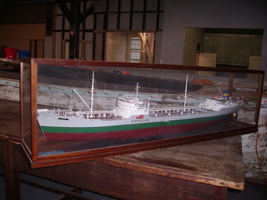 Seaworks Maritime Museum
Shipbuilders model, R W Miller
Original ship - 11,741 gross tons. 589' x 70' x 30' (179.5 x 21.34 x 9.14m). Oil tanker built by Eriksberg Motor Vessels at Gottenburg, Sweden in 1951 for Hjalmar Bjorge of Norway as the Storheim. Purchased November 1964 and renamed R W MILLER. Had a crew of 39 seamen, including the officers. 1973 sold to Independent Shipping Company Pty Ltd of Singapore. Renamed Cherry Victor. Scrapped 1979. Robert Miller traded under the name R W Miller and Company from early 1912. One of Miller's first contracts was to pick up overburden and spoil from the sinking of the Balmain Colliery shaft and dump it at sea. Miller saw the opportunity to sell this material and he ended up getting a sixpence a ton from a local council and other contractors for use as road bases and building foundations. This close association with coal led to Robert W Miller on 15th January 1913 being given the contract for coal distribution from Sydney Harbour Colliery (Balmain mine). So began a long association with coal. Miller built a fleet of lighters that were used to transport blue metal, sand and coal around Sydney Harbour. This introduction into coal transport opened a prospect for him to enter the larger coal shipping transport. During 1917 Miller purchased a vessel, the taking over 1985 by Howard Smith Industries Pty Ltd, Melbourne. Build date 1951-1979. Ship builders model of the tanker R W Miller in a glass case. The body is painted in colours of maroon, green and grey, the deck with detailed fittings and superstructure, an Australian merchant flag flying from the stern, within a mahogany framed glazed display casePlaque at foot of model: M/T R.W. MIILRT/ BUILT GOT. 1951/ OWNERS R.W. MILLER & CO. PTY. LTD/ LENGTH OVERALL 559.04"/ LENGTH BETWEEN P.P 526.06"/ EXTREME BREADTH 70.00"/ MOULDED DEPTH 39.03"/ DEADWEIGHT TONNAGE 18,500/ MACHINERY B & W TYPE A I.H.P 7, 600" on model: "R.W Miller" painted in black -
 Federation University Historical Collection
Book, Optical Society of America, Journal of the Optical Society of America, Volume 20, No. 6, June 1930, 06/1930
A printed journal contaiining the following contents: * Homochromatic Spectrophotometry in the Extreme Ultra-violet (George R. Harrison and Philip A. Leighton) * Parallax Panoramagrams Made Without Relative Movement of Lens, Grating or Sensitive Plate (Herbert E. Ives) * The Chromoliniscope Revisited (Herbert E. Ives) * Some Experiemtns in Mobile Color (G.A. Snook) Images include L.A. Jones, E.C. Crittenden, L.B. Tuckerman, Adolph Lamb, Paul D. Foote. Irvine C. Gardner, Arthur H. Compton. Paul E. Klopsteg. Edgar D. Tilver, Irwin G. Priest, F.K. Rightmyer, Bell System Telephones non-fictionoptical society of americal, e l.a. jones, e.c. crittenden, l.b. tuckerman, adolph lamb, paul d. foote. irvine c. gardner, arthur h. compton. paul e. klopsteg. edgar d. tilver, irwin g. priest, f.k. rightmyer, bell system telephones -
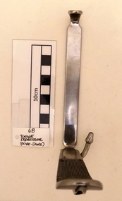 Geoffrey Kaye Museum of Anaesthetic History
Tongue Depressor, Boyle-Davis Gag
Chrome plated metal "L" shaped tongue depressor. The depressor arm downside has cross-hatched grooves to facilitate adherence to the tong. A small metal tube is attached to the upper-side of the depressor through which anaesthesia or oxygen could be administered. The lateral arm handle has grips engraved to attach the mouth gag frame which is missing. This item has a stamp inscription on its handle about maker's details, size and material. Black spots of dust are present inside the metal tube and out near the extreme of the tube. It has accumulated dust between the cross-hatched grooves. Minor scratches around the piece.Stamped in the depressor handle, D.H.A. / 6 / STAINLESSboyle-davis, tongue depressor, airway management -
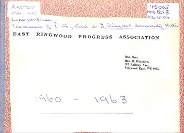 Ringwood and District Historical Society
Administrative record, East Ringwood Progress Association Minutes 1960 - 1963
Regular and annual minutes of the East Ringwood Progress Association from 2 May 1960 to 20 November 1961. The Nov 1961 meeting discussed the longevity of the Association and formed a sub-Committee to investigate. The Association was having extreme difficulty in attracting members and the valuable work, that it did in the past, had generally been completed, with the Council taking over any outstanding work. The final meeting was convened 20 months later and it was passed that the East Ringwood Progress Association be wound up and disbanded. The accrued funds would given to the East Ringwood Children's Library (see cheque butt) and the other assets to the East Ringwood Community Centre. -
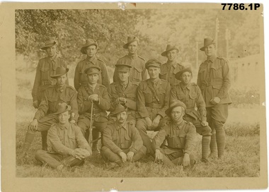 Bendigo Military Museum
Postcard - POSTCARD PHOTOS WW1, Edgar Dawson Collection : Assorted postcards, 1918
This six-postcard group is the seventh in a series of records of items in the collection of Edgar Dawson DCM. Dawson was the Regimental Sergeant Major of 57th Battalion, AIF. C Company of the 57th was composed of men drawn from Echuca, Eaglehawk and Bendigo. The postcards are from his personal album, and many are annotated in Dawson's hand with explanatory notes on the subject. Refer to Cat No 893 for his service details. Items originally in album cat. no. 207P These postcards illustrate the links between battalions, such as the 5th and 47th. 1. Group portrait of the Officers and NCOs of C Company, 47th Battalion. 47th Btn was drawn from Queensland and Tasmania, and C company was primarily Queenslanders. 2. Group photo of the signallers and stretcher bearers of 5th Battalion. Dawson note that Josiah and Norman Rolls, from Golden Square in Bendigo, are in photograph. 3. Group photograph of 57th Battalion medal recipients taken outside Exeter cathedral. 4. 57th Btn band 5 HQ Pioneers, 57th Btn, 8th of October 1917. Dawson notes that the man front row extreme right is 50 years old. 6. Group photo of some officers of the 57th Btn 1. On verso "A.R. Tweddell, 47th Battalion, C Company A.I.F" 2. On Verso "This is a group photograph signallers 5th Battalion Jo and Norm Rolls" 3. "Group taken in Exeter at a a presentation of medals" 4. "This is our band can you pick out Bob Scott" 5. "This is our HQ pioneers who do all our building. The chap on the front row right is fifty years of age and came away with the first contingent. Also the corporal, sergeant and two left had men rear rank" 6. "This is a photo of some of the officers of our battalion. Colonel J.C. Stewart centre, Major R.M. Cotheson on left, Captain Laing M.C. on right. Will tell you the rest when I get home"postcards, 57th battalion, edgar dawson dcm -
 Victorian Interpretive Projects Inc.
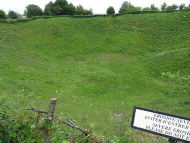
Photograph - Colour, Ann Gervasoni, Lochnagar Crater, 2014, 23/07/2017
The mine was named after Lochnagar Street, the British trench from which the gallery was driven. It was one of 19 mines that were placed beneath the German lines on the British section of the Somme front to assist the infantry advance at the start of the battle. The Lochnagar mine was sprung at 7:28 a.m. on 1 July 1916 and left a crater 98 ft (30 m) deep and 330 ft (100 m) wide, which was captured and held by British troops. The attack on either flank was defeated by German small-arms and artillery fire, except on the extreme right flank and just south of La Boisselle, north of the Lochnagar Crater. The crater has been preserved as a memorial and a religious service is held each 1 July. (Wikipedia)A number of photographs of a crater which was created at the Somme, on the Western Front during World War One. lochnagar crater, tunnellers, the somme, world war one, western front, france -
 Greensborough Historical Society
Photograph, Main Road bridge looking to township of Greensborough, 1929c
View of Main Street Greensborough from Partington's Hill including Plenty River bridge and Marble Hall on corner of Carter Street (now Para Road) and Main Street. This view of Greensborough Park shows the old pan toilets, the hawthorn fence line and the rather undeveloped roadside area of the park. Looking up Main Street we see the old Chapman house at the corner of Poulter Avenue and some newer houses below this. The stone river bridge appears to be only a single lane wide and the road approaching the bridge is unsealed. The rail bridge shows evidence of soot from steam trains and at the extreme left of picture the two concrete buildings indicate the line had been electrified. This occurred in 1923. Sparse housing is seen in the Flintoff Street and Grimshaw Street area.Part of a collection of photographic enlargements of views of Greensborough in the early 1900s.Black and white enlargement of photographic imagemain street greensborough, marble hall, greensborough railway, chapman house, greensborough park, poulter avenue greensborough, carter street, para road -
 Orbost & District Historical Society
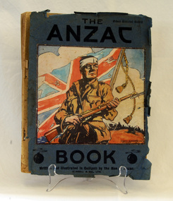
book, Cassell and Company Limited, The ANZAC Book, 1916
This book was originally intended as a Christmas and New Year diversion for soldiers facing a harsh winter in the trenches on Gallipoli. In November 1915 a committee was formed to produce the publication and a notice seeking contributions was circulated at Gallipoli. Prizes were offered for various categories and 150 submissions were received, although not all were incorporated in the book. After the evacuation of Gallipoli, official war correspondent Charles Bean and his assistant, Arthur Bazely, edited the contributions. The drawing on the front cover, "Gallipoli 1915" is by David Baker. Over 100,000 copies of the book were sold. About half went to the AIF and many could also be found in Australian households. It cost 2/6. The illustrations, stories, cartoons and poems for this book were cCreated by soldiers under enemy fire and in extreme hardship. This book is of great historic significance as a contemporary record of The AIF in Gallipoli.A thick 169 pp book with paper cover, titled in black text 'The Anzac Book / Written and Illustrated in Gallipoli by the Men of Anzac.It contains pages of text, some colour illustrations and cartoons. On the cover is a drawing of a determined looking soldier carrying a bayonet in front of a tattered British flag. world-war-1 literature book-the-anzac-book gallipoli -
 Kew Historical Society Inc
Photograph - Yarra Valley Floods: Kew East, 1916
Flooding of the Yarra Valley, including that section of the Yarra bordering Kew and Kew East in the north and west of the municipality, was a regular occurrence. Extreme flood events of the Yarra River are recorded to have occurred in 1891, 1901, 1916, 1923 and 1934. The Municipality of Kew's response to these floods was to enact planning decisions restricting residential development in flood prone areas following the floods of 1916, 1921 and 1934. While floods continued after the development of the Upper Yarra Reservoir (construction 1948-57), the regularity and extent of these inundations diminished. During the nineteenth century, the land abutting the south side of the Yarra in Kew was devoted to dairy farming. In the twentieth century, before and after the construction of the Eastern Freeway, much of this low-lying area was used as golf courses and public parks.One of a collection of photographs of flooding in the Kew section of the Yarra Valley which are in important research resource for the location and extent of flooding in the first half of the twentieth century. Flooding of the Yarra Valley at East Kew in 1916. The view is taken from the intersection of Kilby Road with what is believed to be Birdwood Street, looking across the flood waters to Ivanhoe. The extensive flooded area shown in the photograph would have included the Kew Golf Club. Verso: "Floods along Kilby Road / near Birdwood St? & Kilby Road / 1917? / 87yarra river, yarra valley, floods -- kew, kilby road -- kew (vic.), kew golf club -
 Kew Historical Society Inc
Photograph - Yarra Valley Floods: Kew East, 1916
Flooding of the Yarra Valley, including that section of the Yarra bordering Kew and Kew East in the north and west of the municipality, was a regular occurrence. Extreme flood events of the Yarra River are recorded to have occurred in 1891, 1901, 1916, 1923 and 1934. The Municipality of Kew's response to these floods was to enact planning decisions restricting residential development in flood prone areas following the floods of 1916, 1921 and 1934. While floods continued after the development of the Upper Yarra Reservoir (construction 1948-57), the regularity and extent of these inundations diminished. During the nineteenth century, the land abutting the south side of the Yarra in Kew was devoted to dairy farming. In the twentieth century, before and after the construction of the Eastern Freeway, much of this low-lying area was used as golf courses and public parks.One of a collection of photographs of flooding in the Kew section of the Yarra Valley which are in important research resource for the location and extent of flooding in the first half of the twentieth century. Flooding of the Yarra Valley at East Kew in 1916. The view is taken from a street (maybe Birdwood Avenue) intersecting with Kilby Road looking northeast across the flood waters to Ivanhoe and Heidelberg. The extensive flooded area shown in the photograph would have included remnant dairy farms and the Kew Golf Club. Verso: "Floods / Yarra River / East Kew / Kilby Road / 1917? / 87"yarra river, yarra valley, floods -- kew, kilby road -- kew (vic.), kew golf club -
 Kew Historical Society Inc
Photograph - Flooding of the Yarra Valley at Kew East, 1974
Flooding of the Yarra Valley, including that section of the Yarra bordering Kew and Kew East in the north and west of the municipality, was a regular occurrence. Extreme flood events of the Yarra River are recorded to have occurred in 1891, 1901, 1916, 1923 and 1934. The Municipality of Kew's response to these floods was to enact planning decisions restricting residential development in flood prone areas following the floods of 1916, 1921 and 1934. While floods continued after the development of the Upper Yarra Reservoir (construction 1948-57), the regularity and extent of these inundations diminished. During the nineteenth century, the land abutting the south side of the Yarra in Kew was devoted to dairy farming. In the twentieth century, before and after the construction of the Eastern Freeway, much of this low-lying area was used as golf courses and public parks.Late example of the capacity of the Yarra Valley at Kew to flood, even though drainage works and the Upper Yarra Reservoir had reduced their regularity.Original black and white print photograph of the low-lying land at East Kew under floodwater on 16 May 1974. The vantage point of the photographer is Lister Street. In the photo, the fences of the Kilby Farm can be seen. Flooding was caused by overflowing water in Glass' Creek and the River Yarra. Annotation verso: "Hay's Paddock op No.30 Lister Street / 16 May 1974 11.50am / R.L. 46.04"hays paddock, floods, yarra river, glass' creek, lister street -
 Kew Historical Society Inc
Photograph - Flooding of the Yarra Valley at Kew East, 1974
Flooding of the Yarra Valley, including that section of the Yarra bordering Kew and Kew East in the north and west of the municipality, was a regular occurrence. Extreme flood events of the Yarra River are recorded to have occurred in 1891, 1901, 1916, 1923 and 1934. The Municipality of Kew's response to these floods was to enact planning decisions restricting residential development in flood prone areas following the floods of 1916, 1921 and 1934. While floods continued after the development of the Upper Yarra Reservoir (construction 1948-57), the regularity and extent of these inundations diminished. During the nineteenth century, the land abutting the south side of the Yarra in Kew was devoted to dairy farming. In the twentieth century, before and after the construction of the Eastern Freeway, much of this low-lying area was used as golf courses and public parks.Late example of the capacity of the Yarra Valley at Kew to flood, even though drainage works and the Upper Yarra Reservoir had reduced their regularity.Original black and white print photograph of the low-lying land at East Kew under floodwater on 16 May 1974. The vantage point of the photographer is Lister Street. Flooding was caused by overflowing water in Glass' Creek and the River Yarra. Annotation verso: "Lister Street looking north / Flood level / 16 May 1974 11.30am / R.L. 46.04"hays paddock, floods, yarra river, glass' creek, lister street -
 Kew Historical Society Inc
Photograph - Flooding of the Yarra Valley at Kew East, 1974
Flooding of the Yarra Valley, including that section of the Yarra bordering Kew and Kew East in the north and west of the municipality, was a regular occurrence. Extreme flood events of the Yarra River are recorded to have occurred in 1891, 1901, 1916, 1923 and 1934. The Municipality of Kew's response to these floods was to enact planning decisions restricting residential development in flood prone areas following the floods of 1916, 1921 and 1934. While floods continued after the development of the Upper Yarra Reservoir (construction 1948-57), the regularity and extent of these inundations diminished. During the nineteenth century, the land abutting the south side of the Yarra in Kew was devoted to dairy farming. In the twentieth century, before and after the construction of the Eastern Freeway, much of this low-lying area was used as golf courses and public parks.Late example of the capacity of the Yarra Valley at Kew to flood, even though drainage works and the Upper Yarra Reservoir had reduced their regularity.Original black and white print photograph of Hay's Paddock under floodwater on 16 May 1974. The vantage point of the photographer is Keystone Crescent looking east. Flooding was caused by overflowing water in Glass' Creek and the River Yarra. Annotation verso: "Keystone Cr looking east / 16 May 1974 11.50am"hays paddock, floods, yarra river, glass' creek -
 Kew Historical Society Inc
Photograph - Flooding of the Yarra Valley at Kew East, 1974
Flooding of the Yarra Valley, including that section of the Yarra bordering Kew and Kew East in the north and west of the municipality, was a regular occurrence. Extreme flood events of the Yarra River are recorded to have occurred in 1891, 1901, 1916, 1923 and 1934. The Municipality of Kew's response to these floods was to enact planning decisions restricting residential development in flood prone areas following the floods of 1916, 1921 and 1934. While floods continued after the development of the Upper Yarra Reservoir (construction 1948-57), the regularity and extent of these inundations diminished. During the nineteenth century, the land abutting the south side of the Yarra in Kew was devoted to dairy farming. In the twentieth century, before and after the construction of the Eastern Freeway, much of this low-lying area was used as golf courses and public parks.Late example of the capacity of the Yarra Valley at Kew to flood, even though drainage works and the Upper Yarra Reservoir had reduced their regularity.Original black and white print photograph of the low-lying land at East Kew under floodwater on 16 May 1974. The vantage point of the photographer is Lister Street. Flooding was caused by overflowing water in Glass' Creek and the River Yarra. Annotation verso: "Lister St looking same as No.3 / 16 May 1974 11.30"floods, yarra river, glass' creek, lister street -
 Kew Historical Society Inc
Photograph - Flooding of the Yarra Valley at Kew East, 1974
Flooding of the Yarra Valley, including that section of the Yarra bordering Kew and Kew East in the north and west of the municipality, was a regular occurrence. Extreme flood events of the Yarra River are recorded to have occurred in 1891, 1901, 1916, 1923 and 1934. The Municipality of Kew's response to these floods was to enact planning decisions restricting residential development in flood prone areas following the floods of 1916, 1921 and 1934. While floods continued after the development of the Upper Yarra Reservoir (construction 1948-57), the regularity and extent of these inundations diminished. During the nineteenth century, the land abutting the south side of the Yarra in Kew was devoted to dairy farming. In the twentieth century, before and after the construction of the Eastern Freeway, much of this low-lying area was used as golf courses and public parks.Late example of the capacity of the Yarra Valley at Kew to flood, even though drainage works and the Upper Yarra Reservoir had reduced their regularity.Original black and white print photograph of the low-lying land at East Kew under floodwater on 16 May 1974. The vantage point of the photographer is at Willsmere Road. The road itself is underwater.Annotation verso: "Willsmere Rd / Same as No.7 / 16 May 1974 11.15am"floods, yarra river, willsmere road -
 Kew Historical Society Inc
Photograph - Flooding of the Yarra Valley at Kew East, 1974
Flooding of the Yarra Valley, including that section of the Yarra bordering Kew and Kew East in the north and west of the municipality, was a regular occurrence. Extreme flood events of the Yarra River are recorded to have occurred in 1891, 1901, 1916, 1923 and 1934. The Municipality of Kew's response to these floods was to enact planning decisions restricting residential development in flood prone areas following the floods of 1916, 1921 and 1934. While floods continued after the development of the Upper Yarra Reservoir (construction 1948-57), the regularity and extent of these inundations diminished. During the nineteenth century, the land abutting the south side of the Yarra in Kew was devoted to dairy farming. In the twentieth century, before and after the construction of the Eastern Freeway, much of this low-lying area was used as golf courses and public parks.Late example of the capacity of the Yarra Valley at Kew to flood, even though drainage works and the Upper Yarra Reservoir had reduced their regularity.Original black and white print photograph of the low-lying land at East Kew under floodwater on 16 May 1974. The photograph is of Hyde Park looking north-east.Annotation verso: "Hyde Park looking nth-east / Flood Level / 16 May 1974 11.15am / R.L. 46.61"floods, yarra river, hyde park -
 Kew Historical Society Inc
Photograph - Flooding of the Yarra Valley at Kew, 1974
Flooding of the Yarra Valley, including that section of the Yarra bordering Kew and Kew East in the north and west of the municipality, was a regular occurrence. Extreme flood events of the Yarra River are recorded to have occurred in 1891, 1901, 1916, 1923 and 1934. The Municipality of Kew's response to these floods was to enact planning decisions restricting residential development in flood prone areas following the floods of 1916, 1921 and 1934. While floods continued after the development of the Upper Yarra Reservoir (construction 1948-57), the regularity and extent of these inundations diminished. During the nineteenth century, the land abutting the south side of the Yarra in Kew was devoted to dairy farming. In the twentieth century, before and after the construction of the Eastern Freeway, much of this low-lying area was used as golf courses and public parks.Late example of the capacity of the Yarra Valley at Kew to flood, even though drainage works and the Upper Yarra Reservoir had reduced their regularity.Original black and white print photograph of the low-lying land at East Kew under floodwater on 16 May 1974. The photograph is taken from 43 Kellett Grove.Annotation verso: "Kellett Gve No.43 / Flood Level / 16 May 1974 11.40am"floods, yarra river, kellett grove -
Whitehorse Historical Society Inc.
Document, Melbourne and Metropolitan Archaeological survey, 1/03/1982
History of Aboriginal occupation of the Melbourne area. Evidence of shell midden refuse associated with their campsites. Evidence of scarred trees and scatters of stone artefacts along major stream systems. It has been established that man was in the Melbourne area 40,000 years ago and that Aboriginal occupation probably continued uninterrupted throughout the extremes of the last ice age, around 20,000 years ago when Port Phillip itself was dry land. Study will take 2 - 3 years. Aims (1) identify areas of potential archaeological importance (2) implement a pilot survey program (3) prepare comprehensive proposals for survey of sites. (4) liaise and establish rapport with municipal authorities in study area.aborigines, wurundjeri, bunurong, australian heritage commission, victoria. ministry for conservation, victoria archaeological survey -
 Federation University Historical Collection
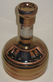
Bottle, Ceramarte, Utopias Beer, 2007
The history of Samuel Adams Utopias comes from the extreme beers of Triple Bock and Millenium that came before it. With those brews The Boston Beer Company began the exploration of aging beer in barrels for a different flavor contribution. In 2002 the first batch of Samuel Adams Utopias was introduced with a complex flavor profile unlike any other beer, and an ABV of 24-29%, making it the strongest naturally-fermented beer to date. Samuel Adams Utopias was brewed in 2003, 2005, 2007, 2009 and 2011. The beer is uncarbonated and ruby black in color with sweet flavors of honey, toffee, caramel, cocoa and vanilla balanced by distinct notes of molasses, raisins, plums and berries imparted from aging batches in a variety of barrels over the years. (http://www.samueladams.com/enjoy-our-beer/beer-detail.aspx?name=utopias) This brew is only released every two years,Gold ceramic unopened bottle containing Utopias beer vintage 2007 brewed by the Boston Beer Company. The beer is a limited 2007 edition with the number 08939. The decanter was handcrafted by Ceramarte of Brazil exclusively or the Boston Beer Company. Samuel Adams is depicted on the bottle. beer, beer awards, utopias, brazil, samuel adams -
 Waverley RSL Sub Branch
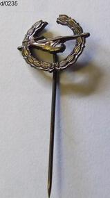
Tie Pin Catalina
The Catalina Club "The enclosed item of military memorabillia is presented to the Waverley Sub-branch of the returned services league by W.F. Lewton, President of the Metropolitan Division of the Piscatorial Council, in appreciation of the services by the sub-branch's anging section. The Lapel badge / tie pin is unique in as much as it depicts the only ex-services organisation granted the privilege of incorporating the Legacy Laural Wreath in it's design. This privilege was granted to our association in recognition of the establishment of an educational trust fund devised and funded by our members in order to educate to tertiary standards the children of personnel who lost their lives in the extreme sacrifice. When the functions of administring the program became too onerous for our members, then, and only then, Legacy undertook to carry the program through to its conclusion. May this Pin find a place of honour in your excellent display of military memorabillia (Accompanying letter when donated) The Lapel badge / tie pin is unique in as much as it depicts the only ex-services organisation granted the privilege of incorporating the Legacy Laural Wreath in it's design. This privilege was granted to our association in recognition of the establishment of an educational trust fund devised and funded by our members in order to educate to tertiary standards the children of personnel who lost their lives in the extreme sacrifice.Bronze tie pin / lapel badge depicting a Catalina Aircraft airbourne surrounded by the (Legacy) laurel wreath -
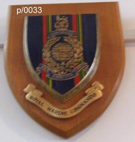 Waverley RSL Sub Branch
Plaque Royal Marine Commando Gibraltar, Royal Marine Commando Gibraltar
The word Gibraltar refers to the Great Siege of Gibraltar by French and Spanish forces, from 1779 to 1783, in support of the American Revolution. It was awarded in 1827 by George IV as a special distinction for the services of four of the old Army Marine regiments (Queen's Own Marines, 1st Marines, 2nd Marines, 3rd Marines) in holding that fortress against determined assaults, despite extreme privation. There are no other battle honours displayed on the colours of the four battalion-sized units of the current Corps. The Latin motto "Per Mare Per Terram" translates into English as "By Sea By Land" describing how the Royal Marines both attack and defend. The fouled anchor, incorporated into the emblem in 1747, is the badge of the Lord High Admiral and shows that the Corps is part of the Naval Service. Per Mare Per Terram ("By Sea By Land"), the motto of the Marines, is believed to have been used for the first time in 1775.Wooden Plaque Royal Marine Commando Gibraltar Royal Marine Commando Gibraltar -
Lakes Entrance Regional Historical Society (operating as Lakes Entrance History Centre & Museum)
Photograph, Weekly Times Newspaper, 1956
Also two copies 04352.1 12 x 18 cm and 04352.2 10 x 15 cmBlack and white photograph of thirty five members of Country Womens Association taken at their twenty first birthday celebrations identified are inside back row Vera Harbeck dark hair and glasses and Rita Lawson short hair, Centre Back Eva Hetherington nee McGuiness of Merrangbaur House with dark hat floral dress Inside back row from right Mrs V Paton white hat and necklace dark rimmed glasses In front of Mrs Paton Mavis Smith floral dress, In front of Mavis, Barbara Ray short hair white earrings Extreme right Miss Bertha Hansen of Venga Guesthouse, Senior woman in front Mrs Stanbury mother of Elsie Ball Victoria House Elsie Mai Bell Fashions, at Lakes Entrance Victoriatransport, entertainment, businesses -
Port Melbourne Historical & Preservation Society
Photograph - Sandridge Beach, 1871
Photographed in 1872 by William PATERSON as one of a series for the Melbourne Exhibition of 1873; original mount hanging in Engineering Department at Port Melbourne Town Hall at 19-9-1994 but now in Port Phillip,City Collection. This set of original prints belonged to Town Clerk Syd ANDERSON, then to his daughter-in-law Phyllis ANDERSON (donor). Accompanied by list of captions, both hand written and typed (the latter a partial listing).View of Beach and piers from Sugar Works, c1871, showing Railway and Town Piers and two jetties in between (caption refers to Donaldson's Jetty), Pier Hotel, gates and some of the yard of the Victorian Sugar Works, and site where Morley's Coal Depot will soon be built, its timber stable and workshop occupied at the time by Carl SEISMAN, mail contractor and owner of the Royal Mail Hotel next door (unseen). The first curved roofed shed can be seen at Town Pier; this remained until demolition in the 1950s. The Post Office Boat House is also visible just before the first small jetty (which is at the place where Alfred LINGHAM's Marine Hotel - the first in the area, 1840 - had its jetty). In the extreme distance Watson's Baths are just visible."P. Anderson" ink, on back.:"7" ink, on face, upper left.piers and wharves - town pier, piers and wharves - railway pier, piers and wharves - donaldson's jetty, sydney sims anderson, town clerks, carl frederick julius seismann, bay street, business and traders - hotels -
 Eltham District Historical Society Inc
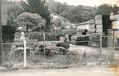
Photograph, N. J. Tillings Timber Factory, 15 June, 1975, 15/06/1975
Fence yard with piles of timber. Weatherboard building in background. This is one of 7 B/W 8x10 inch photos with notes on obverse by Dick Crichton. Accompanying letter from Florence Chrichton 2013 : "Originally sent to Shire of Eltham Engineer, Mr. McDonald. [These photographs were part of their campaign to the Shire of Eltham in 1975] claiming that the zoning regulations were being breached by the occupants of various factories in the nearby light industrial zone [Brougham Street, Eltham] - to the detriment of those living in adjoining residential zones, and that, despite .. earlier objections and complaints, nothing was done about it." 1 black and white photograph printed with white borderInscribed on back: "Ryans Yard, Susan Street, (part owned by Tillings) showing Tillings surplus baulk timber (at extreme right and left) before milling. This timber is often also stored in Peel Street. Majority of baulks are stored at rear or side of Tillings main premises. Eltham High School object to transportation of this timber along Bell and Susan Streets in large semi-trailers. Trucks backing in and out of Tillings cause frequent traffic jams in Bridge Street (often around 8am)." industrial estate, brougham street, eltham, 1975, bolton street, dick crichton, n.j. tillings, timber factory, shire of eltham, susan street, bell street, eltham high school -
 Parks Victoria - Wilsons Promontory Lightstation
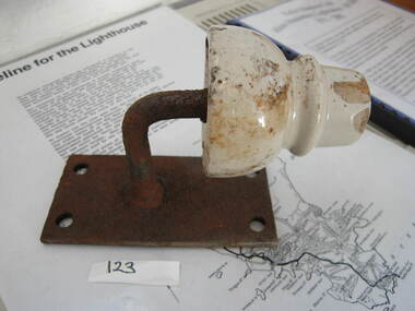
insulator & metal support
The ceramic insulators were used by the PMG to insulate telephone lines connecting to the lightstation accommodation. The installation of a single galvanised wire telegraph line in 1873 provided the lightstation with a vital link to the outside world via Morse code. In 1875, the Australasian Sketcher reported on the new facility, writing that ‘the lighthouse on the extreme point of the promontory is connected with Melbourne by a line of telegraph, and as a large number of vessels pass in sight of the lighthouse, useful information is gained respecting their movements’.The system was immobilised in 1885 when a thunderstorm caused some of the poles to explode and connection wires to fuse and turn into molten metal. During WWII the lighthouse line was upgraded to four copper wires, and in 1971 a radio link replaced the line. The lines required constant maintenance. Some poles remain along the length of the promontory’s Telegraph Track as reminders of this former communication link. Insulators can also be found in the collections at Cape Schanck; Cape Otway and Gabo Island. Comprises a white ceramic insulator attached to a rectangular metal plate. -
 Kiewa Valley Historical Society
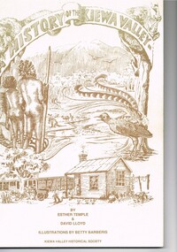
Book - A History of the Kiewa Valley, Kiewa Valley Historical Society, A History of the Kiewa Valley by Esther Temple and David Lloyd, Circa 1991
This book was compiled by Esther Temple and David Lloyd with illustrations by Betty Barberis and additional material provided by Clare Roper, Joan Macdonald, Wilma Davies and Nell Bateman. The book was first penned in 1971. It briefly covers the period from the indigenous tribes(broken down into family groupings) known as the "first Australians" who lived in the valley well before English settlers arrived. first white settlement (graziers, miners, stockmen) to smaller settlements.The development or transformation from a pristine(hunter/gatherer) valley environment to one that has been gradually changing to a more commercial rural/industrial landscaped valley. This transformation was made within a time span of two hundred years. The book details the first pioneers and their descendants, along with the changes to their environments both domestic and commercial. The book highlights dates and events that shaped the "feel" of the valley. The extreme hardships faced by pioneer families during the extremely isolated times away from "civilisation".This publication provides an insight to the struggles and victories against the harsh Australian bushland by people who had not been raised in such a sometimes inhospitable environment. It was this transformation which instilled into the Australian psyche of self sufficiency and the ability to grasp onto ideas or "bush" remedies to overcome enormous difficulties. It is is ability that has produced the many inventions useful in the 20th and 21st centuries.This book has a 250 g/m cream coloured cover with print and drawings of rural aspects of historical significance ( Aboriginal and early white settlers). The book contains 124 pages of black and white photographs(139), black and white sketches(75), two pages of sketches and freehand drawings, two freehand maps one county lease /subdivision plan and black and white printing. See KVHS 0237 (B) for the official invitation to the launch of the book.The front top cover heading(in shaded print and enclosed in a banner form) "A HISTORY OF THE KIEWA VALLEY" The bottom printing "BY ESTHER TEMPLE & DAVID LLOYD ILLUSTRATIONS BY BETTY BARBERIS" and at the very bottom "KIEWA VALLEY HISTORICAL SOCIETY" oN THE BOOK SPINE "A HISTORY OF THE KIEWA VALLEY.....BY ESTHER TEMPLE & DAVID LLOYD"early settlers, dederang, tawonga, mount beauty, sec vic hydro electricity, falls creek early settlers, bonegilla