Showing 235 items matching "farm view"
-
 Eltham District Historical Society Inc
Photograph, Peter Bassett-Smith, Upper Yarra Dam, Spring Tour, 22 Oct 1995, 22/10/1995
EXPLORING THE UPPER YARRA (Newsletter No. 105, November 1995, by Bettina Woodburn) We enjoyed the Spring Excursion, this year "Exploring the Upper Yarra" - in spite of the constant rain and the countryside under the cloud cover, especially in the valleys, being mainly shiny shades of green. The occasional fields of buttercups, clumps of arum lilies and splendid rhododendron and other flowering bushes became very special. The Cobb and Co coach was warm and a cosy retreat as we zig-zagged on the highways and byways to glimpse the Yarra River, upstream and down, its secret places, and particularly the many bridges. Russell excelled as 'Poet Laureate', reading from Dacre Smyth's book. This 1979 publication includes paintings of all the bridges along the river with poems and brief descriptions of each one. Some of the bridges are in out of the way places and are not very well known. We looked forward to hearing the poetry as much as seeing the ' constructions'…Big Pat (was he short or tall, lean or fat? He did win the two hundred pound reward for discovering gold and had the creek named after him), about the 'Eddies'?, and the disliked 'meccano' bridge in Warburton, etc. etc. The hot roast lunch in the old Reefton Hotel was also most welcome. It was easy to imagine it peopled by miners and early settlers. Starting by crossing the new (1974) concrete bridge at Warrandyte we headed through Wonga Park with views to the Christmas Hills and to the escarpment of the Yering Gorge, which causes flood waters to back up through the Yarra Glen plain, so avoiding disasters downstream. At the end of a long driveway we found the wooden, privately owned Henley Bridge (1935 after the 1934 floods). This facilitates access to different parts of Henley Farm and to Lilydale. Everard Park, named after Blanche Shallard's father, a State Member for 17 years, below the Highway Yarra crossing was in need of care. It is 10 miles from Yarra Glen by road but, as "Yarra Marra” canoeists well know, 32 winding miles down by water. After more delightful countryside scenes we joined the Warburton Highway at Woori Yallock. From the old Railway Station at Launching Place the Centennial Trail for walkers, cyclists and ' horse riders has replaced the rails. The line from Lilydale was opened in 1901, and the last diesel freight train ran to Warburton in 1965. It continued to rain as we had morning tea in Warburton in a shelter between footbridges. From here we continued upstream past the Bridge to O'Shannasy Lodge and Reservoir, Starvation Creek, and the Peninsular tunnel (miners dug it as at Pound Bend) which we visited (scrambling down those steps!) on our return after lunch. Our furthermost point was the Upper Yarra Dam Reserve (and vast catchment area). Finished in 1957 after ten years work and 100 years after Yan Yean, it supplies much of Melbourne's water. After crossing the 30m Launching Place Bridge to the Eltham side of the Yarra and Healesville, we saw in the distance the Yarra Glen Timber Trestle Bridge over the river flats "the longest for years in the land it was said!" Harry's dream of "better weather over the Divide" unfortunately didn't come true, but I'm sure we 36 members will retain happy memories of a day that was wet and green and filled with Bridges. Bettina Woodburn - October 1995 Record of the Society's history of activities - Spring 1995 excursionColour photographactivities, upper yarra dam, 1995 -
 Federation University Historical Collection
Booklet, Back to Bacchus Marsh, 1930, 1930
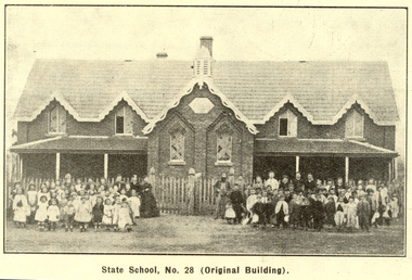
The 1930 Back to Bacchus Marsh celebrations were held on 23 to 28 October 1930. The committee were Cr L.M. Gugdale (president), A.W. Bond (General secretary), W. Grant Morton, J.G. Wells, Dr E. McDonald, Charles Dickie, G.H. Anderson, F.M. Crisp, W.R. Vigor. Bacchus Marsh State School No. 28 was established in 1851 as a National School in a rented building on the right-hand side of Bacchus Marsh-Melbourne Road, just beyond Woolpack Inn. Several willow trees mark the site. H.G. Ball was the first Head Teacher of the school, and the enrolmen towas 34. In 1854 Governor Charles Hotham visited the school. In 1855 two new schools, East and West, were recommended. School No. 28 closed in 1862 and the sitre was sold. The present school site was purchased in 1865 for 67 pounds. The cost of the building was 782 pounds. (Visions and Realisations, Vol 3., 1973) A clock purchased by public subscription was placed in the front of the building to the memory of scholars who served during World War One. (Back to Bacchus Marsh, 1930)Brown covered book of 44 pages. Contents include Bacchus Marsh and its soldiers, Red Cross, Lerderderg Gorge, Werribee Gorge, Lerderderg Park, Coimadai, Darely Firebrick Co., Myrniong, Underbank, Balliang, Rowsley, Parwan, schoosl, churches, Shire Council, Federal Milk Pty Ltd, Bacchus Marsh Milk, Old Maddingley Bridge Images include: * Bacchus Marsh looking east, 1930 * Bacchus Marsh Looking West, 1872 * Bacchus Marsh Looking West, 1930 * Aerial View of Bacchus Marsh Township looking east * Aerial View of Bacchus Marsh Township looking south * Bacchus Marsh Agricultural Society & Pastoral Society, 1893 (named), * Original Bacchus Marsh State School No 28 * Holy Trinity Bacchus Marsh * Bacchus Marsh Baptist Church * St Bernard's Catholic Church * Bacchus Marsh Methodist Church * St Andrew's Presbyterian Church Bacchus Marsh * View of Maddingley Park, showing Original Courthouse, 1890 * Werribee Gorge * Underbank Stud Farm * Ballarat State School Number 28. Signed 'C. Hodgson'bacchus marsh, maddingley, maddingley park, underbank, lerderderg park, coimadai, darely firebrick co., myrniong, balliang, rowsley, parwan, schoosl, churches, shire council, federal milk pty ltd, bacchus marsh milk, old maddingley bridge, police, police paddock, maddingley gates, crisp, mccormack, cain, harkness, howe, bence, mcdonald, mcfarlane, cosgrave, flagg, burnip, scott, lodge, cameron, vallance, bacchus marsh state school, bacchus marsh state school no 28., geology, r.w. thompson, lederderg gorge, weribee gorge, comadai, darley firebrick company -
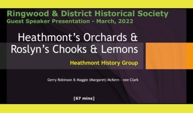 Ringwood and District Historical Society
Mixed media - Video, RDHS Guest Speaker Presentation - "Heathmont's Orchards" - Gerry Robinson and Margaret McKern
Digitised video (3.79GB). Duration: 67 minutes. Recorded March, 2022. (Video is available for viewing at Ringwood & District Historical Society Archives by appointment)Gerry Robinson and Margaret (Maggie) McKern of Heathmont History Group (HHG) combine to present an overview of Heathmont's pioneering orchardists, with Maggie providing a history of her Clark family property, "Roslyn", purchased in the 1930s and operating as a poultry farm and lemon orchard on the corner of Canterbury Road and Armstrong Road in Heathmont. -
 Port Melbourne Historical & Preservation Society
Photograph - Aerial view Maribyrnong and Yarra rivers and Coode Island, c. 1976
Donated to City of Port Melbourne by Councillor Russell GRIFFITHS.Aerial photograph taken from above junction of Yarra and Maribyrnong rivers showing oil and chemical storage farm at Coode Island and four container vessels at Swanson Dock.transport - shipping, piers and wharves - miscellaneous, swanson dock -
 Melbourne Water
Photograph - Turning Of The First Sod, 1908
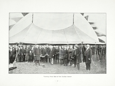
The 19th of May marks the anniversary of the turning of the first sod of the outfall sewer. In 1888, a Royal Commission into Melbourne’s public health led to an ambitious plan to construct a sewerage system of underground pipes, sewers and drains to carry sewage from homes and factories to a sewage treatment farm. The commission also supported the establishment of the Melbourne Metropolitan Board of Works (MMBW), the authority that would build the sewerage system and manage Melbourne’s water supply. This photograph is from The Melbourne and Metropolitan Board of Works Water Supply, Sewerage, and etc Photographic Views, 1908This photograph is in excellent condition and provides a detailed insight into Board personnel of the MMBW. It is of historical importance to the history of Melbourne in the turning of the very first sod.Black and white photographphotograph, mmbw, melbourne metropolitan board of works, melbourne water, historic, turniing of the first sod, book, sewerage, water -
 Bendigo Historical Society Inc.
Book - BENDIGO - THE REGION TO LIVE, WORK & INVEST
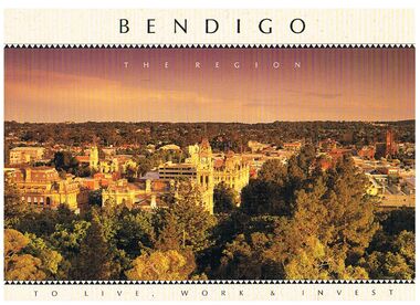
Pale yellow 12 page book titled 'Bendigo the Region to Live Work & Invest'. On the front cover is a scenic view of Bendigo and on the back cover a picture of some quartz and gold nuggets on a green background. Sections in the book are: Live Work & Invest, Lifestyle, Access, Community, Infrastructure, Labour Force, Business, Opportunity, Successes and Information. Each page has a colour picture, they are:- Hargreaves Mall, Eaglehawk Golf Course, Map of Victoria, La Trobe University, Big Hill, Regional Office Department of Planning & Development, Sandhurst Farms, Construction Activity, Products of the Region, Dr. Ian Macbean, Mr Evan Jones and the Capital Theatre with information on each.book, bendigo, bendigo, bendigo - the region to live, work & invest, bendigo regional development board, dr ian macbean, mr evan jones, kate mildren, richard gibbs, express printers, hargreaves mall, eaglehawk golf course, map of victoria, la trobe university, big hill, regional office department of planning & development, sandhurst farms, construction activity, products of the region, capital theatre -
Dutch Australian Heritage Centre Victoria
tourists bicycle pennants, mid 20th century
TourismHow people went on holiday. A memento of simple holidays. The tradition of camping as the holiday of choice.calico, triangular pennant. One edged in blue, the other in red.4089.R1 - blue edged pennant, showing the tourist sites around a place called Epen in the southern part of the province of Limburg. This is known because the name of the town is in large red letters. Three locations shown 1. Kamper Boerderij - A farm providing camping grounds. 2. Kasteel Beusdael - The Beusdael Castle 3. Wingbergermoelen - Wingberger Mill Also a little tent beneath the name of the town, with refers to the camping holiday. Also a maker's mark on the pennant, a small triangle with the letters L, A & B within it. 4089.R2 - red edged pennant, showing the area around Vaals in Limburg province, the name is in large red letters. The scene shows the meeting point between the Netherlands, Germany & Belgium - "Drie Landen Punt" (Three Country Meeting Point) Also shows the height of the viewing point (193m), as well showing other features including: - Hotel Bellevue - Uitzichttoren - viewing tower - Panorama Aken - Panorama of Aachen, Germany - Spoorbrug-Moresnet - Railwaybridge-Moresnet in Belgium. Small makers mark. Black triangle, possible the same as that shown in the other pennant, though obscured. -
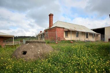 City of Whittlesea
Photograph (item) - Photographs - Buildings, Hin Lim Photography, Blackbraes Farm, 21/6/2017
Blackbraes Farm is listed in the Whittlesea Heritage Overlay HO14, Photographic survey, 10 Cravens Road Merndablackbraes farm, mernda -
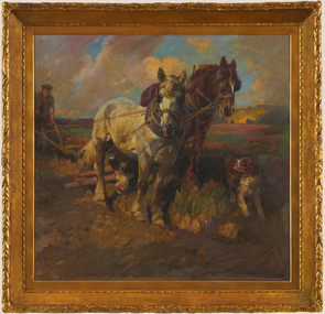 Bendigo Art Gallery
Painting, Harold POWER, Ploughing, 1917
l.r; H S POWER 1917painting, horses, farming, field, ploughing, dog, plough, farmer, agriculture, horse, farm -
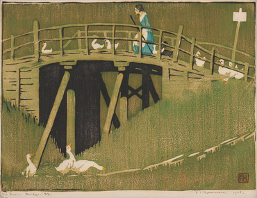 Bendigo Art Gallery
Print - Work on paper, Ethel SPOWERS, The Green Bridge, 1926-1927
l.r; ELS seal, l.r; The Green Bridge 27, l.r; E.L Spowers 1926print, printmaker, printmaking, woodblock, female artist, linocut, bridge, ducks, farming, farm, countryside -
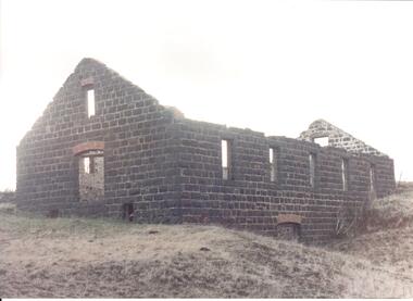 Hume City Civic Collection
Photograph
Rosenthal Winery in Vineyard Road, Sunbury was one of the first wineries established in the area. It was owned by R. F. Kurrle. The roofless building still stands on the property which was part of the dairy farm owned by Tom and Angela Millett. The last vintage from the property was crushed in 1910.A view of the exterior of the ruins of Rosenthal Winery showing 2 sides. It is a bluestone building with a red brick arched doorway at the front and a small narrow arched window above the doorway. Along the side there is another arched doorway at the lower level and 5 paneless windows along the upper level. The pitched gable ends are still standing but the building is roofless.rosenthal winery, wineries, vineyards, vineyard road, sunbury wineries, kurrle, r. f., millett, tom, angela, sunbury, george evans collection -
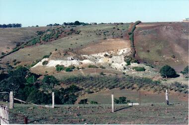 Hume City Civic Collection
Photograph, c Early 1990's
... fence and a partial view of a farm gate in the immediate... fence and a partial view of a farm gate in the immediate ...The Kaolin quarries at Bulla were an important industry in the district and supplied clay products to the Cornwell and Hoffman companies in Brunswick. The Kaolin deposits were found in the 1850's and were considered to be some of the largest in the colony.A landscape photograph of a valley with a post and wire fence and a partial view of a farm gate in the immediate foreground. A clump of native trees are on the LHS and a small grove of almond trees has been planted on the river flat. Kaolin quarry is on the hillside and two buildings can be seen on the hill top. High tension pylons are in the distance near the skyline.kaolin quarries, almond groves, bulla township, deep creek, hoffmans kaolin mine, hoffmans potteries, cornwell potteries, george evans collection -
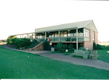 Hume City Civic Collection
Photograph, early 1980s
The series of photographs were taken shortly after the opening of the newly established Goona Warra Golf Club in the early 1980s. The golf club was part of the Goonawarra Housing Estate which was developed on the area previously known as Goonawarra Farm. The new golf club replaced 'The Pines' which was part of the Caloola complex.A coloured photograph of the front view of Goonawarra Golf Club's clubrooms. The building is on 2 levels with a large balcony across the front. Native plants have been planted around the building and a gravel path leads to the building.goona warra golf club, george evans collection -
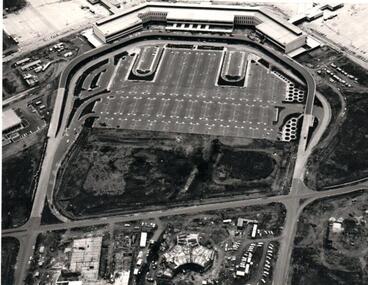 Hume City Civic Collection
Photograph, c 1968
The Melbourne Airport at Tullamarine was constructed during the latter half of the 1960s and was officially opened in 1970.An aerial view of the recently completed airport at Tullamarine showing the Astrojet Centre and the motel under construction in the foreground. The terminal building is in the background.goonawarra farm, goonawarra golf club, goonawarra housing estate, sharkey, robert b., kilkenny homes, villa bella homes, australian ideas homes pty.ltd., glamor homes, craftsmen homes., george evans collection -
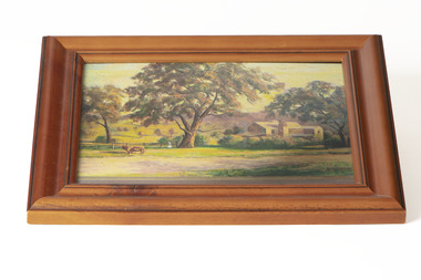 Chiltern Athenaeum Trust
Painting - Artwork, Fanny Bartley, Bartley's Brewery
Bartley's Brewery, Howlong Road, Chiltern (photograph of a painting by Fanny Bartley) Property owned by Benjaming Jackson Bartley 1834-1899Australian Impressionism, Naturalism, Colonial Art, Folk ArtA small, rectangular painting with a wood frame in a basic relief styleSignature in bottom right corner of paintingaustralian landscape, landscape, farm -
 National Wool Museum
Roll of Film
Roll of film taken in the 1930s depicting life on a sheep farm at the time as well as the transportation of wool. Possibly left over roll of film from Photo Album (w7849) with both items from same time period and owner.Roll of paper film containing 24 images. 1 of the images is damaged and difficult to view. An additional 3 are blankFilm roll numbers individual imageswool - transportation, wool growing, sheep station -
 National Wool Museum
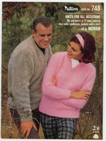
Book, Knitting, Patons Knitting Book no. 748
This book was owned by the late Dr Elizabeth Kerr and was donated to the Museum by the executor of her estate, Margaret Cameron. It was produced by Coats Patons and contains patterns for mens and womens garments knitted in mohair wool. The photographs in this book were taken at 'View Bank', a Welsh mountain pony stud farm owned by Mrs H. Bartramat Heidelberg, Vic.,Patons / BOOK No. 748 / KNITS FOR ALL OCCASIONS / His and hers - a 'V' neck pullover. / Hers only - pullovers, jackets and a skirt / - all in MOHAIR / 2'6 / 25 CENTSknitting handicrafts - history, coats patons (australia) limited, knitting, handicrafts - history -
 Whitehorse Historical Society Inc.
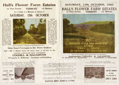
Pamphlet - Advertising brochure, Hall's Flower Farm Estates, 1923
Brochure advertising auction of 'Hall's Flower Farm Estate', Vermont 13 October 1923. 80 sites in three sections, Auctioneers; Coghill & Haughton. Colour and B & W photos.auctions, hall's flower farm estate, short street, vermont, park street, terrara road, canterbury road, view street -
 Whitehorse Historical Society Inc.
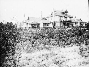
Photograph, Adult Deaf & Dumb Society's Flower Farm
Black and white photograph view of two storey Administrative Block and residents' houses on either side at the Adult Deaf & Dumb Society's Flower Farm at Blackburn Lake.adult deaf & dumb society's flower farm, blackburn lake, flower farm -
 Whitehorse Historical Society Inc.
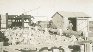
Photograph, Eckermann's Poultry Farm, c1960
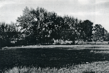
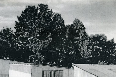
... View from Eckermann's Poultry Farm of Mrs White's house... boyles white bruer's View from Eckermann's Poultry Farm of Mrs ...Photographs relate to the Poultry Farms that existed in Nunawading and Forest Hill in the1950s and 1960s. Photos taken in 1961-62. Poultry farmers included Messrs Boyce, Gallos, Foote,Grimsley, Greenwood and Dudley|Slides scanned as a 'tiff' at 300dpi to CD Rom and cleaned and adjusted by Ted Arrowsmith.View from Eckermann's Poultry Farm of Mrs White's house from Boyle's fence early in morning.eckermann's, eckermann frank, poultry farms, nunawading, greenwood, forest hill, canterbury road, mount pleasant road nunawading, boyles, white, bruer's -
 Whitehorse Historical Society Inc.
Photograph, Eckermann's Poultry Farm, c1960
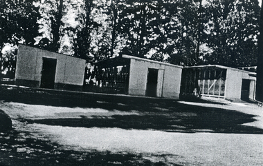
... View from Eckermann's Poultry Farm front of the saw tooth... boyles white bruer's View from Eckermann's Poultry Farm front ...Photographs relate to the Poultry Farms that existed in Nunawading and Forest Hill in the1950s and 1960s. Photos taken in 1961-62. Poultry farmers included Messrs Boyce, Gallos, Foote,Grimsley, Greenwood and Dudley|Slides scanned as a 'tiff' at 300dpi to CD Rom and cleaned and adjusted by Ted Arrowsmith.View from Eckermann's Poultry Farm front of the saw tooth, 2nd last and last pen, taken across back lawn. Built 1956.eckermann's, eckermann frank, poultry farms, nunawading, greenwood, forest hill, canterbury road, mount pleasant road nunawading, boyles, white, bruer's -
 Whitehorse Historical Society Inc.
Photograph, Eckermann's Poultry Farm, c1960
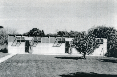
... View of Eckermann's Poultry Farm. The 'new shed' from... boyles white bruer's View of Eckermann's Poultry Farm. The 'new ...Photographs relate to the Poultry Farms that existed in Nunawading and Forest Hill in the1950s and 1960s. Photos taken in 1961-62. Poultry farmers included Messrs Boyce, Gallos, Foote,Grimsley, Greenwood and Dudley|Slides scanned as a 'tiff' at 300dpi to CD Rom and cleaned and adjusted by Ted Arrowsmith.View of Eckermann's Poultry Farm. The 'new shed' from the 2nd last pen looking across the back lawn. Pen used for pullet rearing.eckermann's, eckermann frank, poultry farms, nunawading, greenwood, forest hill, canterbury road, mount pleasant road nunawading, boyles, white, bruer's -
 Whitehorse Historical Society Inc.
Photograph, Eckermann's Poultry Farm, c1960
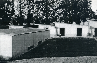
... View of Eckermann's Poultry Farm. The pens from the top... boyles white bruer's View of Eckermann's Poultry Farm. The pens ...Photographs relate to the Poultry Farms that existed in Nunawading and Forest Hill in the1950s and 1960s. Photos taken in 1961-62. Poultry farmers included Messrs Boyce, Gallos, Foote,Grimsley, Greenwood and Dudley|Slides scanned as a 'tiff' at 300dpi to CD Rom and cleaned and adjusted by Ted Arrowsmith.View of Eckermann's Poultry Farm. The pens from the top of the woodshed.eckermann's, eckermann frank, poultry farms, nunawading, greenwood, forest hill, canterbury road, mount pleasant road nunawading, boyles, white, bruer's -
 Whitehorse Historical Society Inc.
Photograph, Eckermann's Poultry Farm, c1960
... View of Eckermann's Poultry Farm. Eggshed and trees from... boyles white bruer's View of Eckermann's Poultry Farm. Eggshed ...Photographs relate to the Poultry Farms that existed in Nunawading and Forest Hill in the1950s and 1960s. Photos taken in 1961-62. Poultry farmers included Messrs Boyce, Gallos, Foote,Grimsley, Greenwood and Dudley|Slides scanned as a 'tiff' at 300dpi to CD Rom and cleaned and adjusted by Ted Arrowsmith.View of Eckermann's Poultry Farm. Eggshed and trees from the top of the woodshed.eckermann's, eckermann frank, poultry farms, nunawading, greenwood, forest hill, canterbury road, mount pleasant road nunawading, boyles, white, bruer's -
 Whitehorse Historical Society Inc.
Photograph, Eckermann's Poultry Farm, c1960
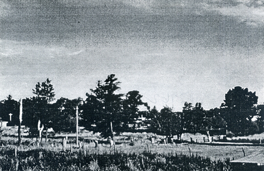
... View from Eckermann's Poultry Farm, looking towards Mt... boyles white bruer's View from Eckermann's Poultry Farm, looking ...Photographs relate to the Poultry Farms that existed in Nunawading and Forest Hill in the1950s and 1960s. Photos taken in 1961-62. Poultry farmers included Messrs Boyce, Gallos, Foote,Grimsley, Greenwood and Dudley|Slides scanned as a 'tiff' at 300dpi to CD Rom and cleaned and adjusted by Ted Arrowsmith.View from Eckermann's Poultry Farm, looking towards Mt Pleasant Road from the top of the woodshed.eckermann's, eckermann frank, poultry farms, nunawading, greenwood, forest hill, canterbury road, mount pleasant road nunawading, boyles, white, bruer's -
 Whitehorse Historical Society Inc.
Photograph, Eckermann's Poultry Farm, c1960
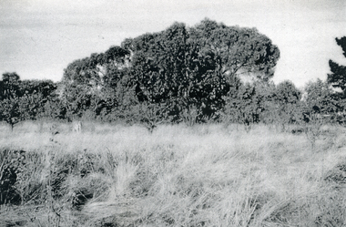
... View from Eckermann's Poultry Farm. Looking towards trees... boyles white bruer's View from Eckermann's Poultry Farm. Looking ...Photographs relate to the Poultry Farms that existed in Nunawading and Forest Hill in the1950s and 1960s. Photos taken in 1961-62. Poultry farmers included Messrs Boyce, Gallos, Foote,Grimsley, Greenwood and Dudley|Slides scanned as a 'tiff' at 300dpi to CD Rom and cleaned and adjusted by Ted Arrowsmith.View from Eckermann's Poultry Farm. Looking towards trees and Mr. Boyle's Orchard from the Eckermann fence, 'Corabelle' in the foregroundeckermann's, eckermann frank, poultry farms, nunawading, greenwood, forest hill, canterbury road, mount pleasant road nunawading, boyles, white, bruer's -
 Whitehorse Historical Society Inc.
Photograph, Eckermann's Poultry Farm, c1960
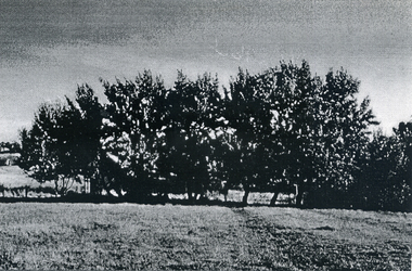
... View from Eckermann's Poultry Farm. Poplar trees and Mrs... boyles white bruer's View from Eckermann's Poultry Farm. Poplar ...Photographs relate to the Poultry Farms that existed in Nunawading and Forest Hill in the1950s and 1960s. Photos taken in 1961-62. Poultry farmers included Messrs Boyce, Gallos, Foote,Grimsley, Greenwood and Dudley|Slides scanned as a 'tiff' at 300dpi to CD Rom and cleaned and adjusted by Ted Arrowsmith.View from Eckermann's Poultry Farm. Poplar trees and Mrs. White's house taken from the Cow Bail.eckermann's, eckermann frank, poultry farms, nunawading, greenwood, forest hill, canterbury road, mount pleasant road nunawading, boyles, white, bruer's