Showing 235 items
matching floods, houses
-
 City of Ballarat
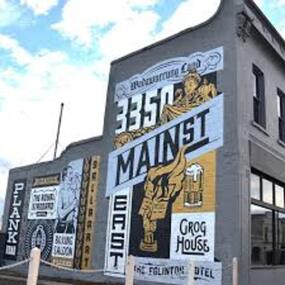
Artwork, other - Public Artwork, Travis Price, Main Road Mural by Travis Price, May 2018
Whilst my main focus for the artwork design was on the Hotels on Main Road, I felt there was an opportunity to tell a broader story of Main Rd and combine/include some interesting pieces of information from many stages of the history of Main Road. Considering that at one point in time there would have been at more than six hotels in this very short section of street….there’s no doubt Main Rd was an epicentre of communication and festivities for the Goldfields of Ballarat. “No matter what luck he had, every miner needed supplies, food and something to entertain him when he was not searching for gold.” Described as being an overcrowded jumble of muddy streets loosely arranged around mining camps...and loud, muddy, colourful and sometimes illicit. I wanted the artwork composition to consist of overlapping images and text to reflect this sense of hustle and bustle. Main Road Mural tells the broader story of the history of Main Road in Ballarat. In 2018, the City of Ballarat commissioned local Ballarat artist Travis Price to create an artwork to align with the Main Road Revitalisation Project and deliver a key component of the storytelling (heritage interpretation) project that spans the length of the shopping precinct. The artwork is featured on a prominent site in the shopping precinct of main road and tells the story of Main Road through depicting key timeline events. Main Road, as its name suggests, was one of the main entries to the mining areas of East Ballarat. It had several names: Main Street before 1858, Plank Road between 1858 and 1868 and Main Road from 1868 onwards. The centre of mining life, it was crowded, prosperous, raucous and dirty. Painted mural on shop wall in Main Road, BallaratBallaarat, Gold Fever, The Royal Standard Hotel, Flood, Boxing Saloon, Plank Road, Kulin Nation, 3350, Election, East, Grog House, The Scandinavian Hotel. Images; Chinese lantern, Pick & Shovel, Miners Licence burning.main road history, ballarat hotels, gold fever, wadawurrung, kulin nation -
 Inverloch Historical Society
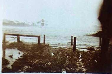
Photograph, 1934 Dec - Pound Creek - tidal floods - pig paddock - side of house - Henderson property
-
 Inverloch Historical Society
000251 - Photograph - 1934 - Pound Creek - Henderson property - floods in front of house - E Henderson
... - Henderson property - floods in front of house - E Henderson ... -
 Inverloch Historical Society
000253 - Photograph - 1934 - Pound Creek - Henderson property - floods - water coming around pig paddock side of house - E Henderson
-
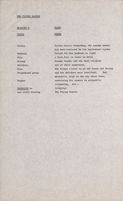 Robin Boyd Foundation
Document - Script, Robin Boyd, The Flying Dogtor. Episode 6 Rain, 1963
The flames closed in on the house and Granny and the children were terrified. But meanwhile, high in the sky above them, exercising his powers in scientific rainmaking, was The Flying Dogtor. The sky was filled with rain and it put out the fire. Crafty Carson Carpetbag and Old Man Redback, with the help of Elvis Evil Eagle, got a hold of the rainmaking powder and schemed to start a flood.The Flying Dogtor" series was broadcast on Australian Television Network (later becoming the Seven Network) between February and April 1964 (see item D254 for schedule).Typewritten, carbon copy, foolscap, 5 pagesthe flying dogtor, robin boyd, crawford productions, manuscript -
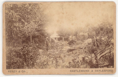 Castlemaine Art Museum
Photograph - Black and white print, Hersche's house, previously Old Mt Alexander Hotel after the flood 01-01-1889
-
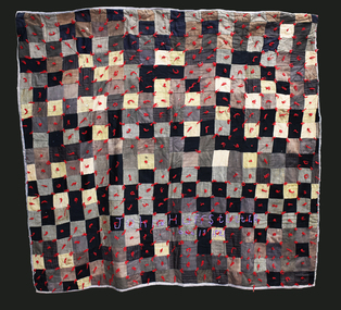 National Wool Museum
Textile - Quilt, 1921
Now 100 years old, this quilt belonged to the donor’s grandfather John William Huffstutter. John was Born in 1898 in a log cabin in the Ozark mountains of Missouri, USA. Tragically, John’s mother died when he was four years old. John said that he could always remember her voice calling his name as he hid under the porch in one of the many thunderstorms that frequent the area with his dog. John was raised by his grandmother and was treated as the youngest to her other children, growing up with his aunties and uncles rather than brothers and sisters. John began to study engineering at the State University of Iowa before serving in the US Army Engineer Corps in The Great War. He enlisted when he became eligible and served briefly before the Great War ended. He then returned to his engineering studies in Iowa, and shortly after finishing his studies got his first job with Westinghouse in Pittsburgh at age 23. It was when John was leaving for this job that he was given the quilts as a reminder of home from his grandmother Sarah Jane "Sallie" Tindall Coble, and her daughter (John's Aunt) Ottie Maude Coble Bittick. Widowed at age 78, John took to sleeping in his screen porch under one of these quilts. John remembered one winter in Missouri waking in his log cabin to find snow covering him and his quilt. When he died at age 94, the quilt he used was completely worn out and discarded. This remaining quilt was shipped to Australia, where Carol’s (the donor) immediate family had emigrated in 1970. Opening the box that contained the quilt released a wave of comforting smells, emotions, and a flood of childhood memories. Carol distinctly remembers sleeping under these quilts for afternoon naps at her grandparents' house. The quilt is 74 x 80 inches (1880 x 2030mm), matching the size of a modern-day king bed. It is made of various four-inch (100mm) squares. These squares are made of old men woollen suits in dark colours of browns and greys. The quilt is layered with a wool backing fabric and a batting lawyer of unknown material, possibly cotton or wool. The quilt is tied together with red wool yarn and the backing fabric is folded over the edge to be used as a binding. Embroidered across the front of the quilt in purple wool yarn is "John Huffstutter", "13 Oct 1921". A small, printed cloth label "HUFFSTUTTER" is pinned on the reverse of the quilt. The quilt is well-worn but in good condition considering its age. The care instructions passed down by word of mouth with the quilt were to "never wash, only air".Front embroidered. Purple handstitching: "John Huffstutter / 13 Oct 1921" Reverse. Printed cloth label: "HUFFSTUTTER"ozark, missouri, usa, textile history, quilt heritage -
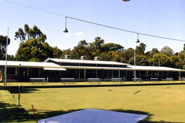 Whitehorse Historical Society Inc.
Photograph, Blackburn Bowling Club, 2012
First games played 1926. The Club was then situated in South Parade. Ladies were invited to join in 1927. The yearly fee was 1.10 sterling. In 1933 the green was officially opened by Robert Menzies. The clubhouse was finally completed in the late 1940's. By the 1960's membership had risen to the extent that a new site was needed. A site on the east side of Pakenham Street, south of the creek, was proposed but it was subject to flooding. In 1966, after the flooding of the creek was managed, the South Parade property was acquired and the new greens were ready by September 1966.Coloured photograph of the Blackburn Bowling Club, Pakenham Street Blackburn. Photograph shows rinks in front of the club house - 2012blackburn bowling club, sporting clubs, pakenham street, blackburn -
 Ballarat and District Irish Association
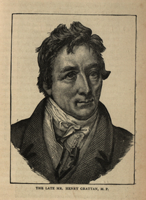
Image, Henry Grattan, M.P., c1864
Born on July 3, 1746, in Dublin, Ireland, Henry Grattan became a brilliant parliamentary orator who pushed for Irish legislative independence from Britain, achieved for a time starting in 1782. As a Protestant, he also advocated for Catholic emancipation and voting rights, clashing with ex-ally Henry Flood over ideology. Later serving in the House of Commons, Grattan died on June 4, 1820. [http://www.biography.com/people/henry-grattan-9318523, accessed 14/12/2013] Born in 1746, died in 1820; was admitted to the Irish Bar in 1772; entered the Irish Parliament in 1775; secured the restoration of independence to the Irish Parliament in 1782; retired from the Irish Parliament in 1797; returned to the Irish Parliament in 1800, in order to oppose the Union; elected to the Imperial Parliament in 1806, remaining a member until his death.[http://www.bartleby.com/268/6/4.html, accessed 14/12/2013] Portrait of a man wearing a jacket. He is Henry Grattan, MP.ballarat irish, henry grattan, henry grattan -
 Mt Dandenong & District Historical Society Inc.
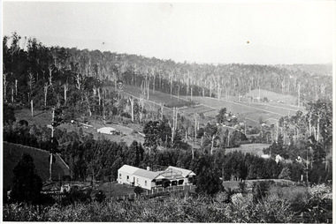
Photograph, The Settlement of Harmony Vale 1913, 1913
View of the settlement of Harmony Vale taken in 1913 with the guest house Kia Ora, built by George Barber in 1909, in the foreground. This photograph has a detailed inscription on the back handwritten by John Lundy-Clarke.The settlement of Harmony Vale 1913. The large home in foreground is the Guest House “Kia Ora” owned by George Barber on Lot 25 of the Village Settlement. The house above it to the left was Richardson’s house. The home of Jeanie who had left it when the picture was taken.The buildings furthest to the right of “Kia Ora” were the homestead of Isaac Jeeves of 1863 – 1871 the building furthest right with the black opening in it was the house with the tree fern floor. The flat ground above and left of Isaac’s pointed roof barn is where the creek changed its course in the 1934 flood and destroyed £4000 worth of the Rowse family’s tulip bulbs. Above the flat is Francis Matthew Child’s homestead, in the creek to the right of which can be seen the horizontal structure of the swing bridge to the sawmill of the Childs Bros which cannot be seen but in the forest to the right of the mill (bridge) can be seen a number of logs in the mill yard. The two cleared strips immediately behind Childs home were the Richardson’s original holdings and the house in the gully at the far side of the great clearing is that of the guest house “Glenrivers” belonging to W Lucas and his wife Catherine nee Child. The Richardson homestead “Harmony Vale” is behind the forest trees in the right centre. The picture gives a full view of how the settlement was cut into the centre of the great forest. george barber, kia ora, harmony vale, barber, jeanie richardson, richardson, child, matthew child, kia-ora guest house, guest house, glenrivers -
 Bendigo Historical Society Inc.
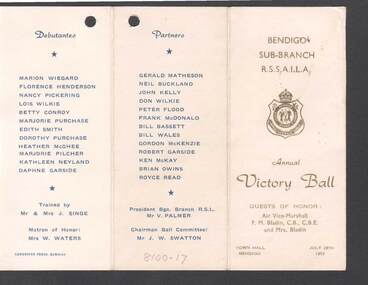
Document - R.S.L. BENDIGO COLLECTION: ANNUAL VICTORY BALL 1953
Two copies of the Bendigo Sub-branch R.S.S.A.I.L.A. Annual Victory Ball held at the Town Hall, Bendigo on July 28th, 1953. Guests of Honour were Air Vice-Marshall F M Bladin, C.B., C.B.E., and Mrs Bladin. Card is cream with gold print on the front and a gold RLS badge. Other printing is blue. The inside of the tri-fold card has a Dance Program of 28 dances and a space for Autographs. The other side has the Debutantes: Marion Wiegard, Florence Henderson, Nancy Pickering, Lois Wilkie, Betty Conroy, Marjorie Purchase, Edith Smith, Dorothy Purchase, Heather McGhee, Marjorie Pilcher, Kathleen Neyland and Daphne Garside. Trained by Mr & Mrs J Singe. Matron of Honor: Mrs W Waters. Partners: Gerald Matheson, Neil Buckland, John Kelly, Don Wilkie, Peter Flood, Frank McDonald, Bill Bassett, Bill Wales, Gordon McKenzie, Robert Garside, Ken McKay, Brian Owins and Royce Read. President Bendigo Branch R.S.L. Mr V Palmer. Chairman Ball Committee: Mr J W Swatton. Printed by Cambridge Press, Bendigo.Cambridge Press Bendigor.s.l. bendigo collection - annual victory ball 1953, marion wiegard, florence henderson, nancy pickering, lois wilkie, betty conroy, marjorie purchase, edith smith, dorothy purchase, heather mcghee, marjorie pilcher, kathleen neyland, daphne garside, mr & mrs j singe, mrs w waters, gerald matheson, neil buckland, john kelly, don wilkie, peter flood, frank mcdonald, bill bassett, bill wales, gordon mckenzie, robert garside, ken mckay, brian owins, royce read, mr v palmer, mr j w swatton, cambridge press -
 Bendigo Historical Society Inc.
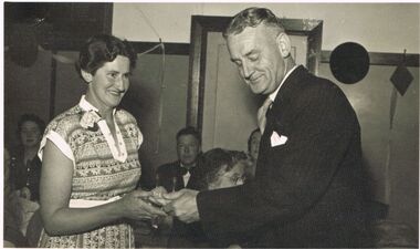
Photograph - BERT GRAHAM COLLECTION: TOM FLOOD, MRS POWELL
Black & white photograph, Bert Graham Collection, Tom Flood is presenting something to Mrs. Powell. Names on the back also Reorder o. B35/11. Kiwi Candid Photos Town Hall Pharmacy, 226 Hargreaves St., Bendigo. Phone 1467.bendigo, clubs, bendigo east progress carpet bowls -
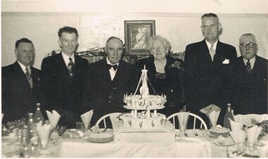
 Bendigo Historical Society Inc.
Photograph - BERT GRAHAM COLLECTION: GROUP PHOTO, 1956
Black & white photograph, Bert Graham Collection, 5 people in photo are from left to right are; Bert Graham, Mr. & Mrs. Tully, Tom Flood, Tom Norris, the occasion was the 25th Birthday 1956, of the Bendigo East progress Association.bendigo, clubs, bendigo east progress association -
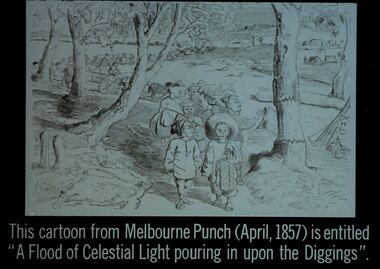 Bendigo Historical Society Inc.
Slide - DIGGERS & MINING. THE CHINESE ON THE GOLD FIELDS, c1857
Diggers & Mining. The Chinese on the Gold Fields. Slide: This cartoon from Melbourne Punch (April, 1857) is entitled ''A Flood of Celestial Light pouring in upon the Diggings''. Slide shows a large group of Chinese travelling to their destination, most of them are on foot. Some onlookers. Markings: 22. Used as a teaching aid.hanimounteducation, tertiary, goldfields -
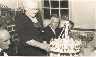 Bendigo Historical Society Inc.
Photograph - BERT GRAHAM COLLECTION: 25TH ANNIVERSARY BENDIGO EAST ASSOCIATION
Black & white photograph, Bert Graham Collection, Mr. Jack Tully, Mrs. Tully cutting the cake, Tom Flood and Bert Graham celebrating the 25th Anniversary of the Bendigo East progress Association, on the tableare wrapped presents , sausage rolls on a plate and a bottle of tomato sauce.bendigo, clubs, bendigo east progress association -
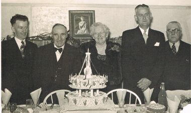
 Bendigo Historical Society Inc.
Photograph - BERT GRAHAM COLLECTION: GROUP PHOTO
Black & white photograph, Bert Graham Collection, five gentlemen and one lady standing behind a table with a birthday cake for the 25th Anniversary of the Bendigo Progress Association, are as mentioned on the back, from left to right; Alwyn Nelson, Bert Graham, Jack Tully, Mrs. Tully, Tom Flood (Mayor), Tom Norris.There is an assortment of soft drinks on the table, sandwiches, and other cakes.bendigo, clubs, bendigo east progress association -
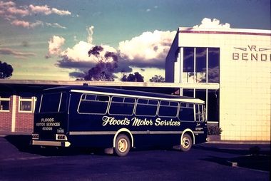 Bendigo Historical Society Inc.
Slide - Floods Motor Service Bus at Bendigo Railway Station, 1970s - 1980s
Local Family owned School bus company established in 1946Floods Motor Service Bus at Bendigo Railway Station; one photo of the coach side and another of the rear.history, bendigo, bus, john theodore collection, floods motor services bendigo -
 Bendigo Historical Society Inc.
Newspaper - LYDIA CHANCELLOR COLLECTION: BENDIGO COMMUNITY
A decorated box containing cuttings from 'The Bendigo Advertiser' of life in Bendigo between 1961 and 1965. Includes weddings, floods, shire and council events, church activities etc.bendigo, history, community activities, lydia chancellor, collection, bendigo, male, female, people, community, people, place, clubs and associations, individual, entertainment -
 Bendigo Historical Society Inc.
Article - JOHN WILLIAMS COLLECTION: NEWSPAPER ARTICLE BENDIGO LINK TOUR CYCLING, 2000s
JOHN WILLIAMS COLLECTION: Newspaper Article Bendigo Link Tour Cycling Newspaper article about Quarry Hill State School Teacher John Williams, three of his students and fathers and their links to the Herald Sun Tours. Photo of the three students, Tyson McCaig, Jack Flood and Nick Crome behind a bicycle. -
 Bendigo Historical Society Inc.
Photograph - SHELBOURNE EAST SS 1012 COLLECTION: BACK TO SHELBOURNE EAST
Black and white photograph of seven women. On the back: Mabel Levershia, Alma Wiegard, Pat Flood, Bill Levershia, Olive Wiegard, Jess Levershia. At back to school E. Sh. With older back to lady (Roberts) Mrs. Jean Brotherton.education, bendigo, shelbourne east -
 Kew Historical Society Inc
Print - Walmer Street Foot Bridge, 1901
Photographic print of the Walmer Street Bridge. The view of the Bridge is from the Abbotsford side of the Yarra. A section of pipe on the near side of the bridge is a remnant of the irrigation pipes that carried water from above Dight's falls to the Melbourne Botanic Gardens. The former bridge, constructed in 1896 was swept away in the 1901 Flood. It has two major brick piers while the remainder of the trestle supports are metal. The original photograph from which this copy was made was taken after 1901 as it shows the second bridge under construction. Houses in Young Street, Kew, can be seen on the far side of the river.Reverse: " Walmer St footbridge 1901 being repaired after flood / Constructed 1892 substantially renewed in 1901 and in 1928 / Rebuilt in 1977 by Kew Council aided by State funding. Won for designer Martin Aylard a New Zealand award presented by the timber Research & Development Assoc / Site of Simpsons Road passenger foot ferry". bridges - yarra river -- kew (vic.), walmer street bridge -- kew (vic.) -
 Kew Historical Society Inc
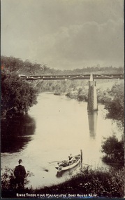
Postcard, River Yarra near Macauleys' Boathouse Kew, c.1910
The Pipe Bridge was constructed to bring fresh water from Fairfield to Kew. This bridge was destroyed in the 1934 Flood and later reconstructed.Early sepia real photo postcard of the first Pipe Bridge bringing water from the Yan Yean Reservoir to Kew. The site is upriver of the original Macauley's boathouse. Obverse: "River Yarra near Macauleys' Boat House Kew". Reverse: "(Pipe Water Line) / Kew to Fairfield above boat house / Pipe Bridge / Received from L. Bennett 1980".bridges - kew (vic.), bridges - yarra river -- kew (vic.), pipe bridge -
 Kew Historical Society Inc
Photograph - Yarra in Flood from Willsmere, North Kew, 1923
Flooding of the Yarra Valley, including that section of the Yarra bordering Kew and Kew East in the north and west of the municipality, was a regular occurrence. Extreme flood events of the Yarra River are recorded to have occurred in 1891, 1901, 1916, 1923 and 1934. The Municipality of Kew's response to these floods was to enact planning decisions restricting residential development in flood prone areas following the floods of 1916, 1921 and 1934. While floods continued after the development of the Upper Yarra Reservoir (construction 1948-57), the regularity and extent of these inundations diminished. Original, large sepia photograph showing men, women and children who have gathered on a grassy verge, probably farm land, to look out across the flooded Yarra Valley at Willsmere, North Kew. In the medium distance are three houses that are largely submerged by the flood waters as well as a number of Eucalypts. Judging by the clothes of the spectators, the date might be 1901 or 1916, but probably the latter due to the hats worn by a number of the women. Inscribed reverse: "Gift of Kerrie Woollard (KCC) (P)C.1923yarra river valley, kew east (vic.), floods, willsmere -
 Kew Historical Society Inc
Photograph - Yarra in Flood, 1934
Flooding of the Yarra Valley, including that section of the Yarra bordering Kew and Kew East in the north and west of the municipality, was a regular occurrence. Extreme flood events of the Yarra River are recorded to have occurred in 1891, 1901, 1916, 1923 and 1934. The Municipality of Kew's response to these floods was to enact planning decisions restricting residential development in flood prone areas following the floods of 1916, 1921 and 1934. While floods continued after the development of the Upper Yarra Reservoir (construction 1948-57), the regularity and extent of these inundations diminished.Black and white print positive. 1934 floods of the Yarra Valley. Location Fairfield looking towards wooded hillside. Houses floating in river.Reverse: "From Fairfield Park (11936?) back towards hill (Wurundjeri Spur?)"floods -- 1934, yarra valley, yarra river, fairfield park -
 Kew Historical Society Inc
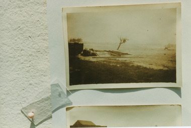
Collection, Floods in North Kew (Series), 1929–1934
Flooding of the Yarra Valley, including that section of the Yarra bordering Kew and Kew East in the north and west of the municipality, was a regular occurrence. Extreme flood events of the Yarra River are recorded to have occurred in 1891, 1901, 1916, 1923 and 1934. The Municipality of Kew's response to these floods was to enact planning decisions restricting residential development in flood prone areas following the floods of 1916, 1921 and 1934. While floods continued after the development of the Upper Yarra Reservoir (construction 1948-57), the regularity and extent of these inundations diminished. Natural disasters had an impact on the development and settlement of Melbourne and its suburbs. Flooding in the Melbourne region was a regular event in the nineteenth and for most of the twentieth centuries. Changes in the impact of natural disasters could occur due to a number of factors. This collection of small snapshots, mostly taken from Kellett Grove in North Kew, provide provenanced evidence of flooding in the area before the development of the unnatural flood barrier that is the Eastern Freeway.Collection of 16 monochrome photographs, annotated on verso by different hands, of the flooding of the River Yarra in North Kew in the third and fourth decades of the twentieth century [1920s & 1930s]. Individual photos include the dates of different floods. Many of the photos were taken from the rear of 8 Kellett Grove; a house still extant in 2023yarra river -- north kew, floods -- yarra valley, floods -- north kew, floods -- 1929, floods -- 1934, natural disasters -- kew -
 Kew Historical Society Inc
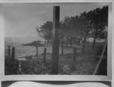
Photograph - Flooding of the Yarra River in North Kew, 1934
North Kew, now divided between Kew and Kew East, bordered the Yarra River. As such, it was a region subject to flooding in the Yarra Valley. Development beyond this point (ie Kellett Grove) was limited by the City of Kew's planning regulations. Prior to urban development, the area since European settlement and the first land sales in the district in the 1840s, had been used for dairy farming. Small sepia snapshot taken from the river ramp of a house at 8 Kellett Grove, in what was then known as North Kew. The point of view is from a backyard looking towards Fairfield. Beyond the fence line are two almost submerged houses. A number of people are in a motor driven boat midstream. Fairfield at this period, (ie 1934) was noted for its limited river side development. Verso: 2/12/34 / TAKEN FROM OUR RAMPyarra river -- north kew, floods -- yarra valley, floods -- north kew, floods -- 1929, floods -- 1934, natural disasters -- kew -
 Kew Historical Society Inc
Photograph - 8 Kellett Grove, North Kew, 1929
North Kew, now divided between Kew and Kew East, bordered the Yarra River. As such, it was a region subject to flooding in the Yarra Valley. Development beyond this point (ie Kellett Grove) was limited by the City of Kew's planning regulations. Prior to urban development, the area since European settlement and the first land sales in the district in the 1840s, had been used for dairy farming. Small sepia snapshot taken of the front of 8 Kellett Grove, in what was then known as North Kew. Verso: 8 KELLETT GROVE / NORTH KEW / 1929 / 418 kellett gove -- north kew, californian bungalows, houses -- kellett grove -- kew (vic.) -
 Kew Historical Society Inc
Photograph - Flooding of the Yarra River in North Kew, 1934
North Kew, now divided between Kew and Kew East, bordered the Yarra River. As such, it was a region subject to flooding in the Yarra Valley. Development beyond this point (ie Kellett Grove) was limited by the City of Kew's planning regulations. Prior to urban development, the area since European settlement and the first land sales in the district in the 1840s, had been used for dairy farming. Small sepia snapshot taken from the back yard of a house at 8 Kellett Grove, in what was then known as North Kew. The point of view is from a backyard looking towards Fairfield. Floodwaters have submerged the fence and a clothes line. Verso: BACKYARD NTH. KEWyarra river -- north kew, floods -- yarra valley, floods -- north kew, floods -- 1934, natural disasters -- kew -
 Kew Historical Society Inc
Photograph - Flooding of the Yarra River in North Kew, 1934
North Kew, now divided between Kew and Kew East, bordered the Yarra River. As such, it was a region subject to flooding in the Yarra Valley. Development beyond this point (ie Kellett Grove) was limited by the City of Kew's planning regulations. Prior to urban development, the area since European settlement and the first land sales in the district in the 1840s, had been used for dairy farming. Small sepia snapshot taken from the back yard of a house at 8 Kellett Grove, in what was then known as North Kew. The point of view is from a backyard looking towards Fairfield. Verso: 8 KELLETT GROVEyarra river -- north kew, floods -- yarra valley, floods -- north kew, floods -- 1934, natural disasters -- kew -
 Kew Historical Society Inc
Photograph - Flooding of the Yarra River in North Kew, 1934
North Kew, now divided between Kew and Kew East, bordered the Yarra River. As such, it was a region subject to flooding in the Yarra Valley. Development beyond this point (ie Kellett Grove) was limited by the City of Kew's planning regulations. Prior to urban development, the area since European settlement and the first land sales in the district in the 1840s, had been used for dairy farming. Small sepia snapshot taken from the back yard of a house at 8 Kellett Grove, in what was then known as North Kew. The point of view is from a backyard looking towards Fairfield. Verso: OUR BACKYARD 8 KELLETT GROVEyarra river -- north kew, floods -- yarra valley, floods -- north kew, floods -- 1934, natural disasters -- kew