Showing 461 items
matching greensborough centre
-
 Greensborough Historical Society
Photograph - Photographs, Rosie Bray, Streetscape at Watsonia shops, 2005
Photographs of the streetscape at Watsonia shopping centre, includes Andres Supermarket, and a seating area and roadway undergoing refurbishment.3 colour photographswatsonia shopping centre, watsonia road watsonia -
 Greensborough Historical Society
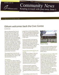
Magazine - Article, Judy Lewis, Eltham welcomes back the Civic Centre, by Judy Lewis, 2008
Article on proposal to move the Nillumbik Shire Council Offices to the site of the old Shire of Eltham offices on Main Road Eltham, adjacent to the Eltham Library2 p., text, black and white and colour photographs. Extract from Eltham Town Community News, Issue 5, Summer 2007-08nillumbik council, eltham, main road eltham -
 Greensborough Historical Society
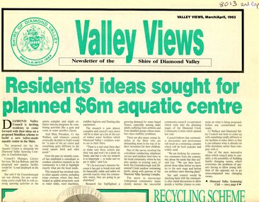
Newspaper - Newsletter, Shire of Diamond Valley, Valley Views: Newsletter of the Shire of Diamond Valley. March/April 1993, 1993_03
Local news from the Shire of Diamond Valley 1993. Includes plans for a swimming pool for the Civic area; extension to the Diamond Valley Library; extended hours for Maternal and Child Health centres; entertainment in the Shire; radio station Plenty Valley fm; and, treatment for headlice.Newspaper, 8p., green and black text, black and white images. 2 copiesshire of diamond valley, swimming pools greensborough, diamond valley library, plenty valley fm -
 Greensborough Historical Society
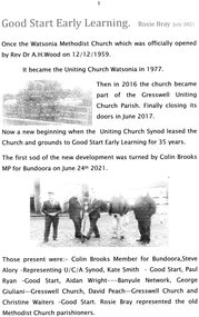
Article, Rosie Bray, Good Start Early Learning, by Rosie Bray, July 2021
Good Start Early Learning childcare centre leased the former Uniting Church Watsonia and grounds (formerly Watsonia Methodist Church) in 2021. A new building is being constructed on the site, to open in September 2022. A brief history of the former churches by Rosie Bray is included 4 p. typescript and photographs; with 4 colour photographsgood start early learning, watsonia uniting church, watsonia methodist church -
 Greensborough Historical Society
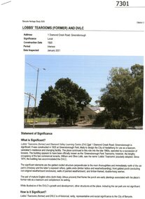
Booklet - Report, RBA Architects, Lobbs' Tearooms (Former) and DVLC, 2021
The building was constructed as a tearoom, probably for the City of Heidelberg in 1925, and has been occupied by the Diamond Valley Learning Centre since 1974. Citation 3 of the Banyule Heritage Study 2020.11p. typescript and colour photographs, stapleddiamond valley learning centre, lobbs tearooms, banyule heritage study 2020, lobb family -
 Greensborough Historical Society
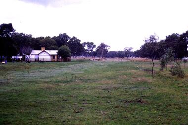
Slide - Photograph, John Ramsdale, Old railway line Whittlesea: Slide 47, 1990s
Photograph shows what appears to be a rural farmhouse and paddock, this is part of the site of the old railway line to Whittlesea. In centre of photo is the old station platform.Part of the John Ramsdale collection of slides and audio visual material.Colour photograph scanned from slide.No maker's marks. No caption on slide.whittlesea, whittlesea rail line -
 Greensborough Historical Society
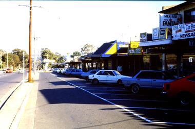
Slide - Photograph, John Ramsdale, Main Road shops, Lower Plenty: Slide 70, 1990s
Photograph shows a shopping centre - Main Road Lower PlentyPart of the John Ramsdale collection of slides and audio visual material.Colour photograph scanned from slide.No maker's marks. No caption on slide.lower plenty, main road lower plenty -
 Greensborough Historical Society
Advertisement - Digital Image, Chicken Fair 1972, 12/08/1972
Advertisement for Chicken Fair of Watsonia Shopping Centre. Copied from a Diamond Valley Football League football record from 1972.Digital copy of advertisement from booklet.diamond valley football league, chicken fair, watsonia shopping centre -
 Greensborough Historical Society
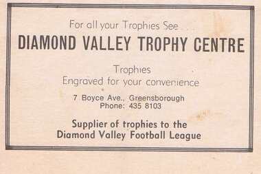
Advertisement - Digital Image, Diamond Valley Trophy Centre 1983, 03/09/1983
... Centre operates from Beewar Street Greensborough.... Trophy Centre of Boyce Avenue Greensborough. Copied from ...Advertisement for Diamond Valley Trophy Centre of Boyce Avenue Greensborough. Copied from a Diamond Valley Football League football record from 1977. In 2020, Diamond Valley Trophy Centre operates from Beewar Street Greensborough.Digital copy of advertisement from booklet.diamond valley football league, diamond valley trophy centre, boyce avenue briar hill, beewar street greensborough -
 Greensborough Historical Society
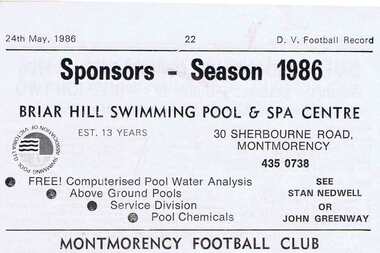
Advertisement - Digital Image, Briar Hill Swimming Pool and Spa Centre, 1986, 24/05/1986
Advertisement for Briar Hill Swimming Pool and Spa Centre of Sherbourne Road Montmorency (Briar Hill). Copied from a Diamond Valley Football League football record from 1986. Digital copy of advertisement from booklet.diamond valley football league, briar hill swimming pool and spa centre, sherbourne road briar hill -
 Greensborough Historical Society
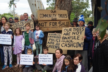
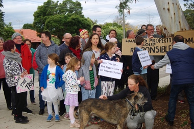
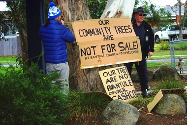
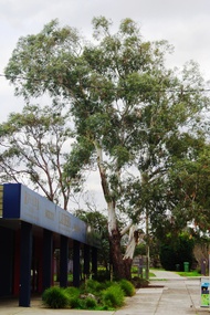
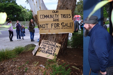
Photograph - Digital Image, Marilyn Smith, Diamond Valley Tree Protest 2019, 25/07/2019
A redevelopment of the Diamond Village area included a multi storey apartment block which required the removal of this tree (Tree 10) on the plans. A VCAT decision ruled that the development be no higher than 4 storeys, and a maximum of 15 dwellings. This photograph shows local residents protesting at the development and removal of tree in July 2019.Digital copy of colour photographdiamond village shopping centre, diamond village, nepean street watsonia -
 Greensborough Historical Society
Photograph - Digital Image, Diamond Valley Tree Protest 2019 - people, 25/07/2019
A redevelopment of the Diamond Village area included a multi storey apartment block which required the removal of this tree (Tree 10) on the plans. A VCAT decision ruled that the development be no higher than 4 storeys, and a maximum of 15 dwellings. This photograph shows local residents protesting at the development and removal of tree in July 2019.Digital copy of colour photographsdiamond village shopping centre, diamond village, nepean street watsonia -
 Greensborough Historical Society
Photograph - Digital Image, Diamond Valley Tree Protest 2019 - signs, 25/07/2019
A redevelopment of the Diamond Village area included a multi storey apartment block which required the removal of this tree (Tree 10) on the plans. A VCAT decision ruled that the development be no higher than 4 storeys, and a maximum of 15 dwellings. This photograph shows local residents placing protest signs at the base of the tree in July 2019.Digital copy of colour photographsdiamond village shopping centre, diamond village, nepean street watsonia -
 Greensborough Historical Society
Photograph - Digital Image, Diamond Valley Tree Protest 2019 - Tree 10, 25/07/2019
A redevelopment of the Diamond Village area included a multi storey apartment block which required the removal of this tree (Tree 10) on the plans. A VCAT decision ruled that the development be no higher than 4 storeys, and a maximum of 15 dwellings. This photograph shows Tree 10 in situ in July 2019.Digital copy of colour photographdiamond village shopping centre, diamond village, nepean street watsonia -
 Greensborough Historical Society
Photograph - Digital Image, Diamond Valley Tree Protest 2019 - GHS members, 25/07/2019
A redevelopment of the Diamond Village area included a multi storey apartment block which required the removal of this tree (Tree 10) on the plans. A VCAT decision ruled that the development be no higher than 4 storeys, and a maximum of 15 dwellings. This photograph shows several GHS members at the protest in July 2019.Digital copy of colour photographsdiamond village shopping centre, diamond village, nepean street watsonia -
 Greensborough Historical Society
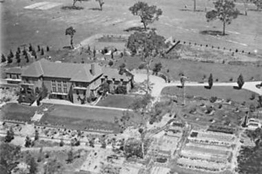
Photograph - Digital Image, Amberley Mansion from the air 1930s, 1930s
An aerial view of Amberley Mansion in Lower Plenty, taken during the 1930s. Amberley was built in the 1920 as a private residence and later as a centre for Christian Brothers. Located on a bend in the Yarra River and now known as Edmund Rice Centre Amberley, it is currently a conference centre, school camp and function centre.An example of an early 20th century building that has survived for over 100 year, with variations to its use.Digital copy of black and white photographamberley, edmund rice centre amberley, christian brothers, lower plenty -
 Greensborough Historical Society
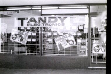
Photograph - Digital Image, Tandy Electronics at Watsonia Village 1976, 1976_
Tandy Electronics at Watsonia Village 1976. Exterior view of shop front and interior views of stock.Digital copy of black and white photographstandy electronics watsonia, watsonia village, watsonia shopping centre -
 Greensborough Historical Society
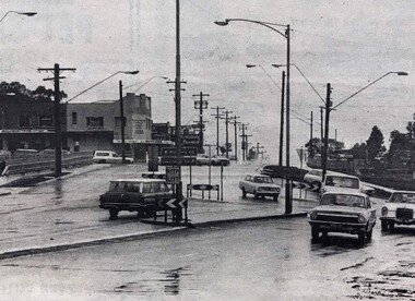
Photograph - Digital Image, Watsonia Junction 1968, 1978_
Watsonia junction 1978. Looking north from Greensborough Road to Lambourn Road and Watsonia Road. Digital copy of black and white photographswatsonia shopping centre, lambourn road watsonia, watsonia road watsonia -
 Greensborough Historical Society
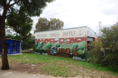
Photograph - Digital Image, Marilyn Smith, Watsonia Timber Supply 2018, 04/12/2018
Watsonia Timber Supply, 58 Watsonia Road Watsonia. This business now trades as Rex Paine Timber and Hardware. This photograph show the mural on the side wall of the building.Digital copy of colour photographwatsonia shopping centre, rex paine timber and hardware, watsonia road watsonia, murals, watsonia timber supply -
 Greensborough Historical Society
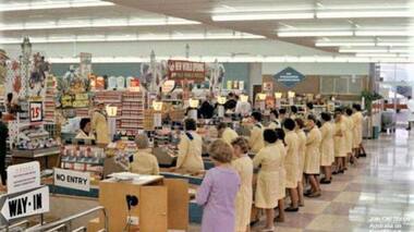
Photograph - Digital Image, Coles New World Greensborough, late 1960s, 1960s
Colour photograph of Coles New World interior with staff at every checkout. It appears to be taken soon after the supermarket was opened (see banner in centre of photo "New World Opening". This store was located in Main Street Greensborough. Digital copy of colour photographcoles new world greensborough, main street greensborough, supermarket -
 Greensborough Historical Society
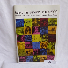
Book, Distance Education Centre Victoria, Across the distance: 1909-2009. Celebrating 100 years of the Distance Education Centre Victoria, 1909-2009
A brief history of the Distance Education Centre Victoria, previously the Victorian Correspondence School. Contains selected examples of students and their work.Soft cover. 97 pages, illus (some colour). Front cover has a collage illustrating distance education work over 100 years.distance education centre victoria, jenny campbell, victorian correspondence school -
 Greensborough Historical Society
Book, Nillumbik Shire Council, 1997 Community Guide Nillumbik, 1997_
Guide to services provided by Nillumbik Shire Council. Nillumbik Shire is located 25 kilometres north-east of Melbourne and the southern boundary is the Yarra River. The south of Nillumbik is predominantly urban, with commercial centres at Eltham and Diamond Creek. The north of the municipality includes significant natural features like Kinglake National Park and Sugarloaf ReservoirAnnual guide to services in Nillumbik. 64 pages. Cover is pale yellow with colour drawings. nillumbik shire council, handbooks -
 Greensborough Historical Society
Book, Nillumbik Shire Council, 1998 Community Guide Nillumbik, 1998_
Guide to services provided by Nillumbik Shire Council. Nillumbik Shire is located 25 kilometres north-east of Melbourne and the southern boundary is the Yarra River. The south of Nillumbik is predominantly urban, with commercial centres at Eltham and Diamond Creek. The north of the municipality includes significant natural features like Kinglake National Park and Sugarloaf ReservoirAnnual guide to services in Nillumbik 72 pages. Cover has white background and some 3-D artwork.nillumbik shire council, handbooks -
 Greensborough Historical Society
Book, Nillumbik Shire Council, 1999 Community Guide Nillumbik, 1999_
Guide to services provided by Nillumbik Shire Council. Nillumbik Shire is located 25 kilometres north-east of Melbourne and the southern boundary is the Yarra River. The south of Nillumbik is predominantly urban, with commercial centres at Eltham and Diamond Creek. The north of the municipality includes significant natural features like Kinglake National Park and Sugarloaf ReservoirAnnual guide to services in Nillumbik76 pages, illus. Cover has photographs of local people and title in white on orange background.nillumbik shire council, handbooks -
 Greensborough Historical Society
Book, Nillumbik Shire Council, Nillumbik Community Guide 2000/2001, 2000-2001
Guide to services provided by Nillumbik Shire Council. Nillumbik Shire is located 25 kilometres north-east of Melbourne and the southern boundary is the Yarra River. The south of Nillumbik is predominantly urban, with commercial centres at Eltham and Diamond Creek. The north of the municipality includes significant natural features like Kinglake National Park and Sugarloaf ReservoirAnnual guide to services in Nillumbik76 pages, black and white illustrations. Cover has a collage of local children with title in white on mid-blue background.nillumbik shire council, handbooks -
 Greensborough Historical Society
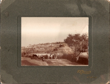
Photograph, Willis Vale 1906, taken from the hill, 1906_
'Willis Vale' home of the Partington family is shown in this photograph as well as the area now known as Partington's Flat. The area was owned and farmed by the Partington family from the 1870s. The derelict Willis Vale house was destroyed in 1964 when a fire originating from North Plenty Gorge - Kurrak Road - lit by two teenage boys - made its way several kilometres down to Partington's Flat Greensborough.Photograph shows an early view of Greensborough in 1906.Professional photograph in sepia mounted on dark green card. Shows Greensborough township in background with Willis Vale homestead in centre. On back: A.M.Partington Greensborough 1906.willis vale, partington family, greensborough, alan partington -
 Greensborough Historical Society
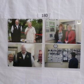
Photograph, Greensborough Historical Society - opening of Resource Centre 22 October 2011, 22/10/2011
... opening of Greensborough Historical Society's Resource Centre ...Photographs taken at the opening of the Resource Centre 22 October 2011. Subjects include GHS President Noel Withers, Mayor of Banyule Peter McKenna and members Faye Fort, Helen Bryant, Marilyn Smith and Frank Evans.Official opening of Greensborough Historical Society's Resource Centre4 x photographs, colour. Tanken at the opening of the Resource Centre in Glenauburn Road.greensborough historical society, resource centre, noel withers, peter mckenna -
 Greensborough Historical Society
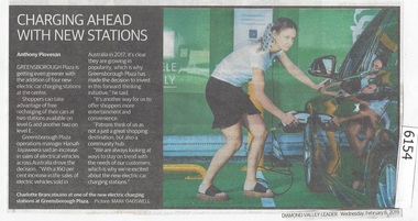
Newspaper Clipping, Diamond Valley Leader, Charging ahead with new stations, 06/02/2019
... stations at the centre. greensborough plaza electric car charging ...Greensborough Plaza is getting even greener with the addition of four news electric car charging stations at the centre.News article 1 page, black text.greensborough plaza, electric car charging stations -
 Greensborough Historical Society
Map, Melbourne and Metropolitan Board of Works. Survey Division, MMBW, Yarra 2500 / 12.20. Watsonia Railway Station and environs, 1983_03
Melbourne and Metropolitan Board of Works. Yarra 2500 [base map]. 12-20, Parishes of Keelbundora 2856, Municipalities of Diamond Valley 257 and 228. Shows street names, easement sizes, lot numbers, lodged plan numbers, names of prominent features, contour values, creek or river names. Watsonia Railway Station and environs. Prominent streets: Watsonia Road, Elder Street, Morwell Avenue and Nepean Street. Includes former Watsonia Technical School and Gresswell Rehabilitation Centre sites.MMBW Map in 1:2500 [scale] series. Cream parchment with green tape reinforcing on edges and punched holes on left edge.mmbw, melbourne and metropolitan board of works, shire of diamond valley, watsonia - maps -
 Greensborough Historical Society
Map, Melbourne and Metropolitan Board of Works. Survey Division, MMBW, Yarra 2500 / 13.22. Greensborough, Apollo Parkways, 1979_06
Melbourne and Metropolitan Board of Works. Yarra 2500 [base map] 13-22. Greensborough, Apollo Parkways. Parishes of Nillumbik 3310 and Keelbundora 2856. Municipalities of Diamond Valley 257 and Whittlesea 239. Prominent streets include: Plenty River Drive, Diamond Creek Road and Civic Drive. Includes Diamond Valley Civi Centre, Churinga, Janefield Colony Reserve and "proposed freeway" now Greensborough Highway (Bypass)MMBW Map in 1:2500 [scale] series. Cream parchment with green tape reinforcing on edges and punched holes on left edge.mmbw, melbourne and metropolitan board of works, shire of diamond valley, greensborough - maps, apollo parkways - maps