Showing 6758 items
matching historic.
-
 Melbourne Tram Museum
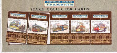
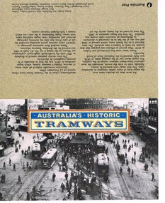
Administrative record - Folder stamps, Australia Post, "Australian Historic Tramways", 1989
Presentation folder of five stamp collector cards printed to celebrate the launch of series of "Australian Historic Tramways" 11 October 1989 by Australia Post. Features each of the stamps on a detachable card within a plastic envelope. On the rear is a note on the tramcars, with a "first day of issue stamp". Five stamps, Adelaide Horse Tram Sydney Steam Tram Melbourne Cable Tram Hobart electric Tram Brisbane Electric Tram. See also Reg Items 470 to 474 for other examples and associated materials and 510 for a Poster. Second set of cards added 20-11-2017 from collection of Ron Scholten - not with a presentation folder, that is loose.trams, tramways, stamps, australia post, cable trams, horse trams -
 Eltham District Historical Society Inc
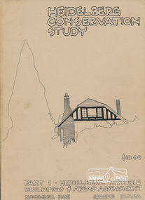
Book, Graem Butler, Heidelberg Conservation Study, Part 1 Heidelberg Historic Buildings and Areas Assessment by Graeme Butler, November 1985
Historic Buildings and Areas Assessment by Graeme Butler. Part 1 of award winning study carried out in 1982 in collaboration with a community advisory committee to Heidelberg City Council. Pioneering identification of a broad range of heritage assets varying from buildings, gravestones, farm structures, landscape areas, mileposts, divided street construction, in a time when buildings only were assessed in municipal studies.2 v. : ill., maps ; 29 cm.significant buildings heidelberg victoria, history development of heidelberg victoria, man-made landscape heidelberg victoria, significant precincts heidelberg victoria, conservation study, graeme butler -
 Melbourne Tram Museum
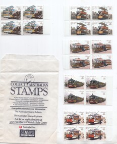
Ephemera - Stamp, Australia Post, "Australian Historic Tramways", 1989
Set of five blocks each of four tram featured stamps issued for the "Australian Historic Tramways" 11 October 1989 by Australia Post. Features a photograph of Hobart Electric trams on the inside cover, with the five stamps behind a plastic sheet. On the front is a photo of Railway Square Sydney, the rear cover has a description of the trams and of Australian tramways. Five stamps, all 41c: Adelaide Horse Tram Sydney Steam Tram Melbourne Cable Tram Hobart electric Tram Brisbane Electric Tram. See Reg Item 470, Reg Item 471 to 474 for other examples and associated materials and 510 for a Poster. Contained within an Australia Post stamp packet.trams, tramways, stamps, australia post, cable trams, horse trams -
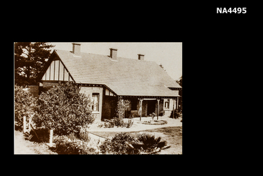
 Hymettus Cottage & Garden Ballarat
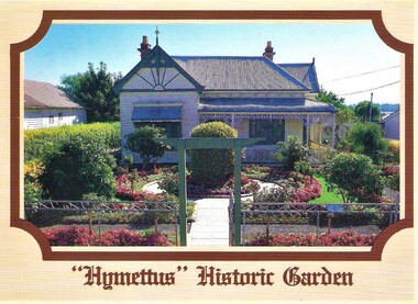
Postcard, Nu-Color-Vue Productions Pty Ltd, Hymettus Historic Garden, 1986
Hymettus Historic Garden and its cottage museum were opened to the public in 1985 after two years of garden restoration work. The interpretive work was undertaken by Mr and a team from Melbourne's Royal Botanical Gardens and the Taffe family. Plans were drawn up by Peter Lumley and Michael Looker of the Royal Botanical Gardens and the work of restoration undertaken by the family with financial assistance from Heritage Victoria and The City of Ballaarat. historic garden, ballarat, hymettus, postcard, royal botanical gardens melbourne, restoration, city of ballaarat. -
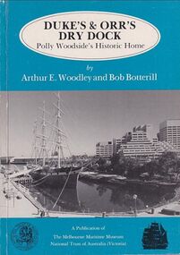 Mission to Seafarers Victoria
Book, Arthur E. Woodley et al, Duke’s & Orr’s Dry Dock, Polly Woodside’s Historic Home, 1985
70 pages : illustrations, facsimiles, mapsnon-fictionduke and orr dry dock, polly woodside, national trust, yarra river, south wharf, interest group -
 Melbourne Tram Museum
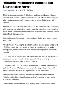
Newspaper - Digital Image, The Examiner, “'Historic' Melbourne trams to call Launceston home”, 9/4/2019
Digital image of newspaper clipping titled: “'Historic' Melbourne trams to call Launceston home”, by Jessica Willard Newspaper article with pictures of two Melbourne trams numbers 742 and 770 being loaded and transported from Newport Railway Workshop to Launceston. Initially they will be put into storage until consultation with local council and community groups. Plans include transforming the trams into indoor seating areas in Riverbend Park. The trams will travel on the Spirit of Tasmania More than 1500 applications were received through the expression of interest process, which was mostly for W-Class trams retired from Victoria's railway and tram network over the past 30 years. VicTrack is in the process of allocating all retired trams from Newport and is expected to take two years.trams, tramways, w class, w5 class, sw5 class, newport workshops, launceston, tram 742, tram 770 -
 Melbourne Tram Museum
Administrative record - Folder stamps, Australia Post, "Australian Historic Tramways", 1989
Presentation folder of five stamps, 41c, to celebrate the launch of series of "Australian Historic Tramways" 11 October 1989 by Australia Post. Features a photograph of Hobart Electric trams on the inside cover, with the five stamps behind a plastic sheet. On the front is a photo of Railway Square Sydney, the rear cover has a description of the trams and of Australian tramways. Five stamps, all 41c: Adelaide Horse Tram Sydney Steam Tram Melbourne Cable Tram Hobart electric Tram Brisbane Electric Tram. See also Reg Item 471 to 474 for other examples and associated materials and 510 for a Poster. Second copy from donation of Shirley Ramsay, Hawthorn Historical Society added 15-1-2018. See Reg Item 4701 for a set of five blocks (4 stamps) of each.trams, tramways, stamps, australia post, cable trams, horse trams -
 Federation University Historical Collection
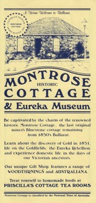
Card - Card - Advertising, ZILLES COLLECTION: Advertising Card for Historic Montrose Cottage and Eureka Museum
Zilles Printers was begun by Lewis Zilles in the early 1930s. It was in McKenzie Street Ballarat. His son Jeffrey also became a printer - letterpress, offset and screen printer. The business became Zilles Printers/Graphics and was in Armstrong Street and later Bell Street Ballarat. Montrose Cottage was build c1856 by John Alexander, builder. He was a Scottish stone mason. It was built with bluestone and hand-made bricks. It is on the Historic Buildings Register, National Trust (Victoria). It is important as a substantial and very early stone cottage. The house is now open to the public. It also provides short term accommodation - self contained apartments.Yellow card with dark blue printDrawing of cottage and on reverse side map.zilles printers, montrose cottage, john alexander, scottish stone mason, bluestone, hand-made bricks, historic buildings register, short term accommodation, national trust, apartments -
 Whitehorse Historical Society Inc.
Postcard
Sepia postcard showing photograph of Strathdon Homestead Nunawading Historic Orchard 1931 |'City of Nunawading Library Information Service' printed on bottom left hand corner.Heritage Postcards 6 Historic Photographsdocuments, postcards -
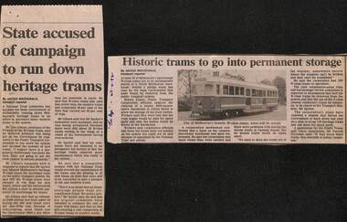 Melbourne Tram Museum
Newspaper, The Age, "State accused of campaign to run down heritage trams", "Historic trams to go into permanent storage", "Trust furious at plans to mothball old trams", 2/1992 to 4/1992
Set of three Newspaper clippings written by Jacqui Macdonald, about the withdrawal and storage of W class trams. ,1 - The Age 11/2/1992 - titled "State accused of campaign to run down heritage trams", quotes Don Gibson Chairman of the Friends of the W class at the National Trust and Minister Peter Spyker. Comments around the cost of maintenance. .2 - The Age 27-4-1992 - titled "Historic trams to go into permanent storage", includes a photo of SW5 758, to a North Melbourne warehouse in Alfred St, about 50 trams, without bogies, PTC spokesman said to secure storage. .3 - The Age 28/4/1992 - titled "Trust furious at plans to mothball old trams" - Quotes Don Gibson, not happy, more trams than needed, space issue, cost of overhauls, compared to new trams. Has a photo of Mr Brown, opposition transport spokesman, policy to keep as many as possible and run them.trams, tramways, w class, maintenance, national trust, withdrawn trams, stored trams, tram 758 -
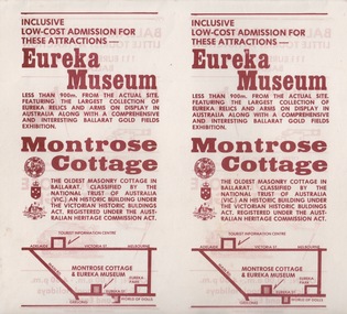 Federation University Historical Collection
Document - Document - Advertising Cards, ZILLES COLLECTION: Advertising Card for Historic Montrose Cottage and Eureka Museum
Zilles Printers was begun by Lewis Zilles in the early 1930s. It was in McKenzie Street Ballarat. His son Jeffrey also became a printer - letterpress, offset and screen printer. The business became Zilles Printers/Graphics and was in Armstrong Street and later Bell Street Ballarat. Montrose Cottage was build c1856 by John Alexander, builder. He was a Scottish stone mason. It was built with bluestone and hand-made bricks. It is on the Historic Buildings Register, National Trust (Victoria). It is important as a substantial and very early stone cottage. The house is now open to the public. It also provides short term accommodation - self contained apartments. Double sided cards advertising Montrose Cottage and Eureka Museum. Printed by Zilles Graphic Industries, Ballarat. White card with russet colour print. Printed on both sides. Each side has Eureka Museum and Montrose CottageEureka Flag and Cannon. Drawing of Montrose Cottage and flag with Lion. Symbol of National Trust Australia. Coat of Arms. Location map.zilles graphic industries, montrose cottage, eureka musuem -
 Bendigo Historical Society Inc.
Magazine - LYDIA CHANCELLOR COLLECTION; HISTORIC HOMESTEADS
A green folder containing newspaper articles from 'The Sun,' 'Walkabout' magazine and a 1969 calendar all about historic homes of Australia.Historic homesteads of Australia. National Trust Oct. 1069.national trust, properties, historic homesteads, lydia chancellor, collection, homesteads, history, australia, buildings, place, national trust -
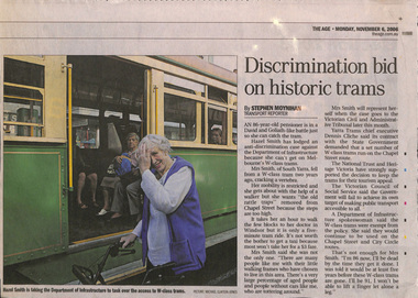 Melbourne Tram Museum
Newspaper, The Age, "Discrimination bid on historic trams", "Tram delays leave disable behind", 6/11/2006 12:00:00 AM
Series of four newspaper cuttings about discrimination access to trams and wheel chair users. .1 - The Age 6/11/2006 - "Discrimination bid on historic trams" - about Hazel Smith taking Dept of Infrastructure to court about the use of W class trams on the route 78 line. Notes she had a fall on this tram and suffered injuries. Has comments from the Dept and Yarra Trams. .2 - The Age? undated c2012 - "Tram delays leave disable behind" about the lack of progress in making trams more accessible, Australian Human Rights Commission, Transport, Minister Lynne Kosky and quotes from a wheel chair user, John McKenna and Vic Council of Social Services Cath Smith. .3 - The Age? - undated c2013 - Next trams years away for disabled travellers - similar issues - has a photo of Wendy Brooks in her wheelchair near the Royal Melbourne Hospital. .4 - The Age 10/5/2018 - "Tram traps: wheels not welcome" - looking at disability access tram stops, routes access and the cast of James Carter missing a stop and not able to get off until the tram returned. Has a map of route 96. Also quotes Daniel Bowen of the PTUA and Human Rights Commission.trams, tramways, melbourne, tramways, disability services, doi, route 78, route 96, superstops -
 Bendigo Historical Society Inc.
Book - HISTORIC BUILDINGS COUNCIL - VICTORIA, 1990s (?)
12 page booklet about the Historic Buildings Council of Victoria. Includes background and aims of the council, membership, building registers, heritage planning and education and sketches of various buildings. Blank inserts. 2 copies of pink form 'Application to add building to Register' and 2 copies of white form 'Application for Financial Assistance'Historic Buildings Council of Victoriacottage, miners -
 Eltham District Historical Society Inc
Document, Russell Yeoman, Tour of Historic Buildings and Locations, 1978
Self guided heritage tour information produced by the Shire of Eltham Historical Society for 1978 Eltham Community Festival of 36 locations each numbered on accompanying map. Locations and detail provided current to 1978: 1. ELTHAM SHOPPING CENTRE Whilst very little remains in the centre of historical importance, this area has interest as the "village" which developed over many years following the opening of the railway from Melbourne in 1902. Previously the shopping centre had been spread out over a long length of Main Road to the south. Shops have been continuously demolished or remodelled and the majority of buildings date from the 1950's or later. The recently erected Post Office replaced the "old" Post Office opened on the same site only in 1958. 2. WOOLWORTHS ELTHAM VILLAGE Part of the site of this modern shopping development was occupied by the former Eltham Shire Offices and Hall. The hall was paid for by public subscription whilst the Council raised a loan for the offices. The combined building was opened in 1941. It served as office and Council meeting place until 1965 and as the hall until its demolition in 1970. 3. ELTHAM WAR MEMORIAL The complex of buildings adjoining the present Shire Offices were financed by public subscription as a Memorial following World War II. Their construction and for many years their operation was organised by the now disbanded Eltham War Memorial Committee. The original buildings were the; Infant Welfare Centre, Children’s Library (now War Memorial Hall and Dental Clinic) and Kindergarten. In later years the Elderly Citizens Club was built at the rear. 4. ELTHAM SHIRE OFFICES These offices were opened in 1965 and extended in 1971 to provide additional office accommodation and the Eltham Library. They represent the last of a long line of offices and meeting places of the Eltham Shire Council and its predecessor the Eltham District Road Board. The building occupies the former site of Shillinglaw Cottage. The three tall cypress trees which stood in front of the Cottage have been retained as a feature of the office surrounds. 5. OUR LADY'S CHURCH AND SCHOOL The Catholic Church and School complex opposite the Shires Offices shows a number of stages in the development of Eltham township. The recently constructed church adjoins its predecessor (now the parish centre). Many years ago the Catholic Church was located opposite Wingrove Park and the present central site follows the northerly drift of the township. 6. SHILLINGLAW COTTAGE The Cottage was built in 1859 by George Stebbing, a local builder who was responsible for a number of other prominent buildings in the area. Its removal from the site of the Shire Offices and re-erection on the present site was financed by public subscription. It is built of handmade bricks laid in Flemish Bond with an unusual design featuring burnt "leader" bricks over the whole facade. The Cottage is occupied by Eltham Fleececrafts and will be open during the Festival and at other times during weekends. It is classified by the National Trust. 7. RAILWAY BRIDGE The timber trestle bridge over the Diamond Creek was built in 1901. Whilst all of its timbers have been replaced at various times over the years the only change to its character has been the addition of pylons and wiring for electric trains in 1923. It is one of very few similar bridges remaining in the metropolitan area. In 1976 a proposal to replace the bridge with an earth embankment and large culvert pipes was abandoned following community protests. The bridge, however, remains under threat because of the necessity for future deuplication of the railway line. 8. ELTHAM CENTPAL PARK The area between the railway and the creek has for many years been used as a park which included Eltham' s main football oval. The access road, Panther Place is named after Eltham's team playing in the Diamond Valley League. In recent years a large area extending to Bridge Street and locally known as the Town Park has been landscaped and added to the area. The excellent blending of the park with the natural landscape of the creek valley has earned a National Trust Landscape Classification. 9. OLD BAKERY On the southern corner of York Street and Main Road is an old house with a shop front which was for many years the local baker's shop. The brick bakery at the rear is of somewhat later vintage than the house. 10. BRIDGE STREET CUTTING Before reconstruction of Main Road this intersection had deep cutting embankments on all four corners, forming a distinctive feature of the entrance to Eltham. Roadworks and private development have levelled the land on the low side of the road. A memorial to the Eltham soldiers of World War I which was located at the north-western corner is now situated at the Eltham R.S.L. 11. HILLTOP MILK BAR For many years this was the site of the Eltham Post Office under the control of the Hunniford family and later their descendants the Burgoynes. It was transferred to this site in 1855, although at that time the building apparently fronted Bridge Str e et. The site contained Eltham's first telephone exchange. The post office was relocated in 1954 but the shop was operated until recently by the Burgoyne family who still own the surrounding land. 12. UNITING CHURCH and former C.B.A. BANK The former Methodist Church was built in 1880 by George Stebbing. The Sunday School extension was built in 1929 and there have been more recent extensions. The adjoining opportunity shop was built as a bank in 1874 and purchased by the Methodist Church in 1954. 13. R.S.L. HALL, TELEPHONE EXCHANGE These relatively recent buildings occupy the site of a row of shops forming part of the early ribbon of business development along Main Road. In front of the R.S.L. building is the World War I Memorial relocated from the corner of Bridge Street and Main Road. 14. ELTHAM COMMUNITY CENTRE Australia's first mudbrick "community building" was opened in April this year. Part of the site of the building was purchased in 1856 by Henry Dendy (of Brighton fame). At the rear of the land near the creek was a steam flour mill whilst Dendy's house was at the Main Road frontage of the land. His purchase totalled about 2 Ha (5 acres) and included land on the opposite side of Maria Street (Main Road). Dendy became a prominent member of the Eltham community and served one term as President of the Eltham District Road Board. In 1867 Dendy sold his land and business to William Ford of Malmsbury and shifted to Walhalla. The avenue of trees leading past the Community Centre to the creek may well have bordered the track to the mill. 15. ELTHAM HOTEL The original part of this hotel was built in 1927 following the burning of the former Watson's Eltham Hotel on the same site. The car park on the opposite side of Main Road was also the site of a hotel variously known over the years as; the Fountain of Friendship, the Fountain and the Evelyn Arms. As the Fountain of Friendship it was the first meeting place of the Eltham District Road Board in 1856. 16. ST. MARGARET'S CHURCH, PITT STREET In 1860 Henry Dendy was appointed Chairman of a committee to establish a church of England in Eltham. He donated part of his land in Pitt Street and in 1861 the church was opened. It was built by George Stebbing and remains in a well preserved state today. Th adjoining old vicarage is now named Dendy Hou se. A new mudbrick church hall is under construction on the site. The church and Dendy House are now listed on the Register of Historic Buildings. 17. NO. 86 PITT STREET Cottage built by George Stebbing and believed to be his home for some years in the 1850s. 18. LIVING AND LEARNING CENTRE The house was built in the 1850s with the kitchen at the front being added about 40 years later. By the creek below the house a number of early Eltham industries were located. These included a tannery and a brewery. 19. ELTHAM COURT HOUSE A Court of Petty Sessions was established in Eltham in 1858 and the present building dates from 1860. It is the oldest public building remaining in Eltham. In its early days the building was used as the meeting place and office of the Eltham District Road Board and as an overflow classroom for the local school. The Court House has been classified by the National Trust. The citation states that it is an example of the simple form of early brick Court House with gabled roof and porch. 20. LANDS DEPARTMENT OFFICE This building is the former police station and is probably of about the same age as the Court House. The lockup at the rear has been demolished but the old stables remain as garages. A licence was first granted for a police station at Eltham in 1856. 21. JARROLD COTTAGE The old Cottage opposite Dalton Street was formerly owned by the Jarrold family. Early records indicate that this was the building leased from the Jarrolds as a temporary police station prior to construction of the building on the corner of Brougham Street. The small building on the corner of the property was used as a boot repairer's shop. The elevated studio at the rear is a more recent construction by the present owners. 22. STATE SCHOOL RESIDENCE Erected in 1891 23. WINGROVE COTTAGE This building fills an important place in the history of Eltham and is now used as a medical clinic. It was built in 1858 for Charles S. Wingrove who was Secretary to the Eltham District Road Board and Shire Council from 1858 to 1904. During part of this period he was also Shire Engineer and was Secretary to the Heidelberg Road Board. The house was used as the office of the Board and Council for many years. Wingrove is buried in the cemetery at St. Helena. 24. WINGROVE PARK The parkland opposite Wingrove Cottage has been named after Charles Wingrove. The old Manna Gums are an outstanding feature of the park. 25. ELTHAM FRI.MARY SCHOOL NO. 209 The school first opened in the slab building in 1855 and operated from the present site since 1857. The oldest part of the present school is the stone building erected in 1876. The first school teacher, David Clark remained at the school until 1888. This school is the government township and has always been known as the Eltham School. An earlier school (no.371) known as Little Eltham School operated in Swan Street from 1853 to 1872. 26. "SHOESTRING" This house was built for school teacher David Clark. It has been extensively extended in recent years but the extensions do not detract from the character of the older part of the building. 27. ELTHAM CEMETERY The cemetery contains the graves of many of the district's pioneers . 28. MONTSALVAT This unique complex of buildings was commenced in 1935 by the late Justus Jorgensen and its development has extended over many years. Montsalvat has exerted a significant impact on Eltham The earth and stone construction of many of the buildings has influenced local architecture to a great extent and it has served as a "nerve centre" of the local artistic community. Montsalvat is open to the public for a small charge. 29. MAIN ROAD BRIDGE This location has been the main crossing of Diamond Creek since the earliest days of settlement. The present concrete bridge was erected in 1925 .and was preceded by a number of timber bridges. 30. ELTHAM LOWER PARK This park, being an unusually large flat area for Eltham, was originally the local racecourse. Horse races were held here from 1855 and the area was gazetted as a reserve for a racecourse and recreation reserve in 1857. The park is well known as a venue for school "bird days" and more recently as the site of the Diamond Valley Railway. This miniature railway features scale models of modern and old locomotives and rolling stock and has operated on this site since 1961 . Before that the railway operated at Chelsworth Park, Ivanhoe. 31. FALKINER HOUSE Frederick Falkiner was one of the earliest settlers in the Eltham township area and occupied a substantial leasehold prior to the first land sales. Early records show that Falkiner was the subject of a number of complaints from his neighbours but he has nevertheless been considered a prominent enough citizen to have a street named for him. This house was the home of Evelyn (Ely) Falkiner a member of Frederick's family. 32. WEST HOUSE Behind the large house on the hill is an early house built by the West family. This was relocated from a site near the front of the land by the present owner Mr. Fabbro. 33. FALKINER HOUSE This very old house is believed to have been the home of Frederick and may have been Eltham's first post office. Falkiner was the first post master for a short period. in 1854/55. 34. WITHERS HOUSE This house was the home of famous artist Walter Withers who shifted here from Heidelberg in 1903. 35. ELTHAM HIGH SCHOOL This school celebrated its jubilee this year, having commenced as the Eltham Higher Elementary School 50 years ago. 36. DIAMOND CREEK FOOTWAY If returning from the High School to the town centre the footpath by the bank of the Diamond Creek provides a pleasant route to finish your walk. The creek is a major tributary of the Yarra River. Together with its own major tributaries Arthurs Creek and Running Creek it commences on the southern slopes of the Dividing Range at Kinglake. It gives the name Diamond Valley to an area extending well beyond its actual drainage catchment.Recognition of the significance of various landmarks to the history of the Eltham community as of 1978‘shoestring’, 1978, bridge street cutting, burgoyne store, c.b.a. bank, diamond creek trail, eltham cemetery, eltham central park, eltham community centre, eltham community festival, eltham court house, eltham festival, eltham high school, eltham hotel, eltham lower park, eltham primary school, eltham railway trestle bridge, eltham shire offices, eltham shopping centre, eltham state school no. 209, eltham village, eltham war memorial, falkiner house, heritage trail, hilltop milk bar, jarrold cottage, lands department office, living, living and learning centre, main road bridge, montsalvat, old bakery, our eltham artistic recollections, our lady help of christian’s church, our lady help of christian’s primary school, pitt street, post office, r.s.l. hall, shillinglaw cottage, st margaret’s church, state school residence, stebbing cottage, telephone exchange, uniting church, west house, wingrove cottage, wingrove park, withers house, woolworths -
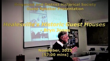 Ringwood and District Historical Society
Mixed media - Video, RDHS Guest Speaker Presentation - "Healesville's Historic Guest Houses" - Bryn Jones
Digitised video (3.11GB). Duration: 57 minutes. Recorded November, 2023 (Video is available for viewing at Ringwood & District Historical Society Archives by appointment)Presenter: Bryn Jones, President of Healesville Historical Society, takes us back through the ages uncovering the origins and growth of Healesville's attraction as a local and international tourism destination, with a mix of tall tales and true stories associated with some of the guest house goings-on. -
 Eltham District Historical Society Inc
Folder, Victorian Goldfields Project: Historic gold mining sites in St Andrews mining division, 1999
Heritage site report and gazetteer by David Bannear, head consultant for archealogy for the Department of Natural Resources and Environment. Includes information on the Warrandyte Goldfield and the Caledonia Goldfield, Queenstown (now known as St Andrews), One Tree Hill, Kingston (now known as Panton Hill), Kangaroo Grounds, You You Hill, Kingstown, South Morang, Nillumbik, (now known as Diamond Creek), Steele's Creek, Yarrambet and Kinglake. Photocopy of map headed: Location of mines and reefs from Geological survey of Victoria, Yan Yean with the Diamond Creek prominant on the map. no date35 page report with map and print out of cover letter (email form) from donorcaledonian gold fields, caledonina gold field, david bannear, gold mining, harry gilham collection, queenstown, st andrews, warrandyte goldfield -
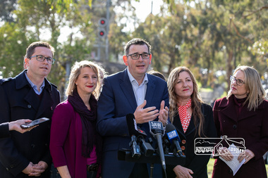 Eltham District Historical Society Inc
Photograph, Peter Pidgeon, Victorian Labor Government Press Release announcing planned upgrades to Hurstbridge line rail services and protection of historic Railway Trestle Bridge, Panther Place, Eltham, 1 August 2018, 1 Aug 2018
Announcement by Premier Daniel Andrews, Minister for Public Transport, Jacinta Allan and Member for Eltham, Vicki Ward mad alongside the Eltham Railway Trestle Bridge. MEDIA RELEASE "More Trains And Fewer Delays On The Hurstbridge Line" https://www.premier.vic.gov.au/wp-content/uploads/2018/08/180801-More-Trains-And-Fewer-Delays-On-The-Hurstbridge-Line-1.pdf Commuters on the Hurstbridge line will have more trains, more seats and fewer delays with a re-elected Andrews Labor Government to continue its massive upgrade of the Hurstbridge line. The Andrews Labor Government said it would deliver locals in Melbourne’s north-east more peak hour train services and less time stuck at boom gates, and we have. The first stage of the Hurstbridge Line Upgrade has been delivered – six months early and on budget. This includes the new Rosanna Station, duplicated track between Heidelberg and Rosanna and the removal of the dangerous level crossings at Alphington and Rosanna. There’s more to do and only Labor will deliver the next stage of the Hurstbridge Line Upgrade to give local commuters more train services and a more comfortable commute. The $530 million project will include a brand new train station at Greensborough and the duplication of three kilometres of track between Greensborough and Montmorency, and 1.5 kilometres of track between Diamond Creek and Wattle Glen to allow more train services during the morning peak. This will allow trains to run every six and a half minutes at Greensborough, every 10 minutes at Eltham and Montmorency, and every 20 minutes at Hurstbridge, Diamond Creek and Wattle Glen – as well as two extra Hurstbridge express services. Locals on the Labor Government’s new Mernda line will also get five extra train services during the morning peak, with a major upgrade of the Clifton Hill junction where the Mernda and Hurstbridge lines connect. Labor will also protect the Eltham Trestle Bridge – the last remaining timber bridge on Melbourne’s electric train network – which has local heritage protection and is an important part of the area’s character. The Liberals will leave this bridge to rot and demolish the nearby childcare centre and football club with their under-cooked and under-costed promise to upgrade the Hurstbridge line. Only Labor will protect this important piece of Melbourne’s history with planning work to be carried out for a long-term solution as part of the project. Stage two of the Hurstbridge Line Upgrade will create more than 950 jobs, with construction to start in 2020 and finish by 2022. Quotes attributable to Premier Daniel Andrews “We said we’d upgrade the Hurstbridge line and remove dangerous and congested level crossings at Rosanna and Alphington and we did – but there’s more to do.” “Only Labor will deliver the next stage of the Hurstbridge Line Upgrade with a new Greensborough Station and more trains, more often.” Quote attributable to Minister for Public Transport Jacinta Allan “The former Liberal Government promised new train lines but didn’t deliver a single kilometre of track – now they’re promising a half-baked upgrade of the Hurstbridge line with rubbery figures that don’t add up.” Quote attributable to Member for Eltham Vicki Ward “As a fifteen year old hopping on Red Rattlers at Eltham I wanted to do something to make the Hurstbridge line better. It’s taken me a few decades but finally our line will offer the frequency of services that are expected and needed in a 21st century city.”Born digital image (qty 27)jacinta allan, minister for public transport, panther place, premier daniel andrews, press announcement, railway line construction, trestle bridge, vicki ward mp for eltham, victorian parliament -
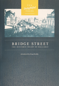 Federation University Historical Collection
Booklet, Doug Bradby, Bridge Street: The Historic Heart of Ballarat, 2020
Twenty eight page dark green covered book on Ballarat's Bridge Street, including information on the Gravel Pits, Main Road shops, floods, Chinese cerneval, Queen carneval, Yarrowee Bridge, Eureka Stockade, fire, Yarrowee Creek.non-fictionballarat, gravel pits, main road shops, floods, chinese cerneval, queen carneval, yarrowee bridge, eureka stockade, fire, yarrowee creek, bridge street -
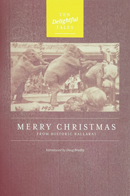 Federation University Historical Collection
Booklet, Doug Bradby, Merry Christmas From Historic Ballarat, 2020
Twenty eight page maroon covered book on Christmas on the goldfields of Ballarat.non-fictionballarat, christmas, goldfield -
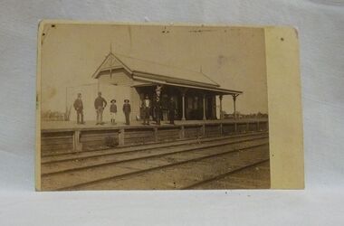 Wycheproof & District Historical Society Inc.
Sepia photo, Photographer unknown, Historic Wycheproof Railway Station, 1904 (estimated)
This railway station building was erected in 1887 and closed in 1990. Now a new chapter begins with a newly restored station building amd platform that re-opened in October 2010 to be used by the Wycheproof Community.The Wycheproof Railway station constructed by Hossack & Brown in 1887 is Heritage listed and is on the Government Buildings Register. This photo is one of only a few available of the early days of the Station.The complex is historically significant at a State level AHC A.4. The Railway station contains significant detailing such as in the turned timber posts and overall composition. This early photo of Wycheproof railway station, shows a construction of timber with corrugated iron clad roof,in c.1904. Features of the design are the timber verandah posts with decorative elements which include chamfers and supporting diagonal timber brackets. The gabled roof has finials on the east and west ends. Seven people pose on the platform,the staff in uniform of the times.Nilregister, , railways, wycheproof, historic buildings, 1900s -
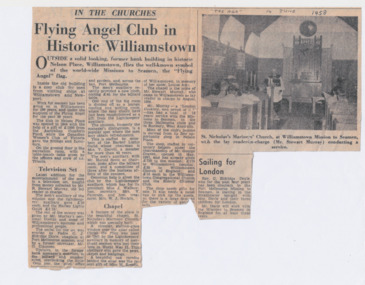 Mission to Seafarers Victoria
Article - Newspaper clipping, The Age, Flying Angel Club in Historic Williamstown, 14 June 1958
Colour photocopy on A4 size paperInscription handwritten in black ink in capital letters by Nancy Oakley: "The Age" 14 June 1958nancy oakley, mission to seamen, nancy dingle, williamstown, st nicholas the mariner chapel, randall stewart murray, george craven, opportunity shop, claude james eldridge-doyle, maude breaks, reredos, louise (lulu) amy breaks, hlg, j. wallace, mrs v. paterson, mrs w.j. hockin, mrs v. darvill -
Phillip Island and District Historical Society Inc.
Book, Australian Council of National Trusts, Historic houses of Australia, 1974
Stamped 'Cowes Public Library'.historic buildings, australia, history -
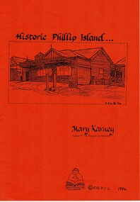 Phillip Island and District Historical Society Inc.
Book, KARNEY, Mary, Historic Phillip Island, 1994
HistoricalA4 orange soft covered with photocopied pages. phillip island, victoria, history, mary karney, robb family, west family, postal services, chicory industry, rescue practice, severance of phillip island, albert k. t. samble, cr dawson davie, water supply, ferries, broadwater guesthouse cowes phillip island, phillip island library -
Phillip Island and District Historical Society Inc.
Book, VALENTINE, James, Then and now : historic roads around Sydney, 1939
-
 Greensborough Historical Society
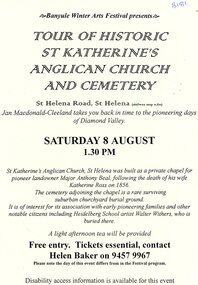
Flyer - Flyer and notes, Tour of historic St Katherine's Anglican Church and cemetery, 1990s
Tour of St Katherine's Anglican Church and cemetery, facilitated by Jan Macdonald as part of the Banyule Winter Arts Festival in the 1990s.2 pages, text only. st katherines church, st helena, anthony beale, st helena cemetery, banyule winter arts festival -
 Greensborough Historical Society
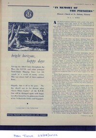
Article - Magazine clipping, A. A. Burns, "In Memory of the pioneers": Historic Church at St Helena, Victoria, 01/08/1949
A short history of St.Katherine's church in St.Helena includes information on Anthony Beale.Printed from Trove records. Printed on white paper with photo illustrations.st.helena, st.katherine's church, anthony beale -
 Mission to Seafarers Victoria
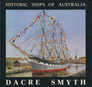
Book, Dacre Smyth, Historic Ships of Australia, : A third book of paintings, poetry, and prose, 1982
Foreword by Admiral Lionel Lockwood.non-fictionkeith oliver, donation, commodore dacre smyth, commodore dacre smyth (1923-2008) -
 Greensborough Historical Society
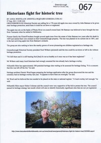
Newspaper clipping, Historians fight for historic tree by Anna Whitelaw, 27/09/2011
Greensborough Historical Society are calling for a 170 year old apple tree once owned by John Batman to be given heritage protection.The "Batman apple tree' in Greensborough is believed to be the last existing tree from those brought to Victoria from Tasmania by John Batman. The tree was planted on the present site by the Flintoff family in 1841.A4 printout of article from Banyule and Nillumbik Weekly. Colour photograph and textjohn batman, batman apple tree, flintoff family, greensborough historical society, noel withers, dennis ward -
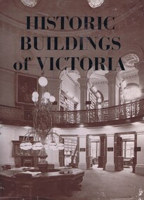 Greensborough Historical Society
Book, Historic Buildings of Victoria, 1966_
A listing of National Trust listed buildings from around Victoria in 1966. Each entry has a photograph and caption with some history of the building. Arranged by region.The development of architectural style in Victoria.278 pages, black and white illustrations. Hard cover. Dust jacket has illustration of interior of the Library of the Supreme Courtmelbourne architecture, victoria architecture, historic buildings victoria, national trust of australia, victoria