Showing 22514 items matching "inverness-shire"
-
 City of Greater Bendigo - Civic Collection
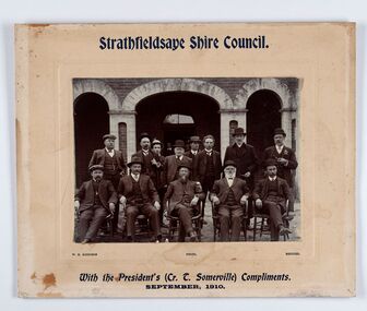
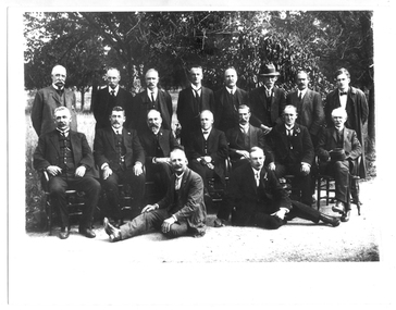
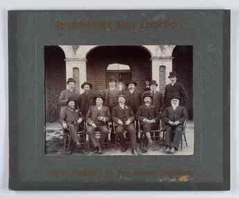
Photograph - Councillor group portrait, W H Robinson, Strathfieldsaye Shire Council
The district of Strathfieldsaye was proclaimed in 1861 and named a Shire on the 17th September in 1866. It remained a shire until amalgamation in 1994 when it became part of the City of Greater Bendigo. The shire was located 8 km to the south- east of Bendigo and covered an area of 601 square kilometres and extended from the Calder Highway to the Coliban and Campaspe Rivers. The shire's administration centre was in Strathfieldsaye until 1972 when new offices were opened in Kennington. Group portrait of 13 men / councilors, 5 seated and 8 standing dressed in suits. There are another 2 men further back in front of the hall doors. Photograph is taken outside the Strathfieldsaye Shire Hall.Srathfieldsaye Shire Council. / With the President's (Cr T. Somerville) Compliments. / September, 1910 / W.H. Robinson Photo. Bendigo Verso; William Drechslershire of strathfieldsaye, president of strathfieldsaye shire, strathfieldsaye shire council -
 Eltham District Historical Society Inc
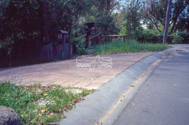
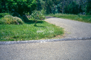
Slide - Photograph, Eltham Shire Council, Roadside drainage control, unidentified road, Shire of Eltham, c.1989
Eltham Shire Council review of various kerb profiles and road side drainage35mm colour positive transparency Mount - Black and Whiteinfrastructure, footpaths and gutters, road drainage, roads, shire or eltham, streets -
 Eltham District Historical Society Inc
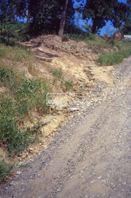
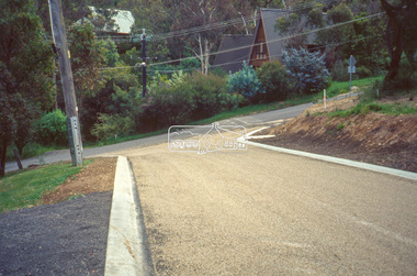
Slide - Photograph, Eltham Shire Council, Roadside drainage control, unidentified road, Shire of Eltham, c.1989
Eltham Shire Council review of various kerb profiles and road side drainage35mm colour positive transparency Mount - Black and Whiteinfrastructure, footpaths and gutters, road drainage, roads, shire or eltham, streets -
 Eltham District Historical Society Inc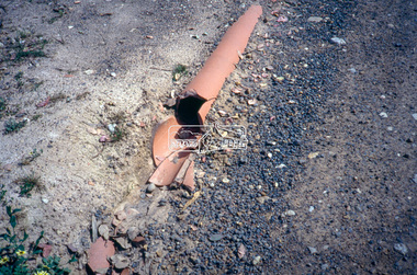
Slide - Photograph, Eltham Shire Council, Roadside drainage control, unidentified road, Shire of Eltham, c.1989
Eltham Shire Council review of various kerb profiles and road side drainage35mm colour positive transparency Mount - Black and Whiteinfrastructure, footpaths and gutters, road drainage, roads, shire or eltham, streets -
 Greensborough Historical Society
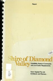
Book - Feasibility Study, Gunn Hayball Pty Ltd, Shire of Diamond Valley: Feasibility study of community arts and crafts requirements, 1977, 1977_
An investigation into the need for, and availability of art and craft activities in the Shire of Diamond Valley in 1977.68 pages text and black and white line drawings and tables. Black plastic binding. non-fictionshire of diamond valley, leisure activities, art and craft -
 Greensborough Historical Society
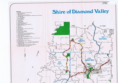
Map, Map - Shire of Diamond Valley, 1990c
Map issued by the Shire of Diamond Valley showing location of key organisations and features Map printed in colour, one sideshire of diamond valley -
 Pyrenees Shire Council
Photograph, Shire of Lexton Councillors and Officers, 1958
significant to the Pyrenees Shire and Lexton communityFramed Photograph of Shire of Lexton Councillors and Officers 1957-8 "Inscribed front: Shire of Lexton Councillors & Officers 1957-1958" -
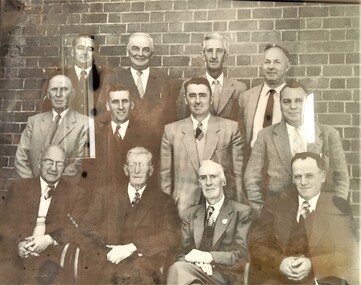
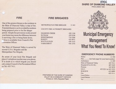 Greensborough Historical Society
Pamphlet, Municipal Emergency Management: what you need to know: Shire of Diamond Valley, 1990c
Shire of Diamond Valley Municipal Emergency Management pamphlet with emergency phone numbers and procedures. Circa 1990s.Pamphlet 2 sided printed on cream paper, text only.shire of diamond vallety, emergency services -
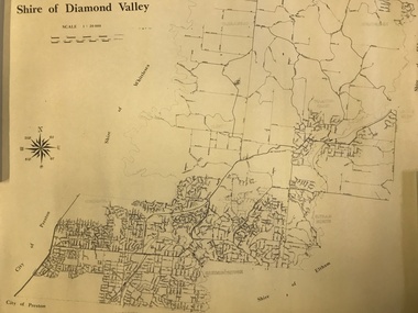 Greensborough Historical Society
Map, Shire of Diamond Valley, 1964-1994
Map of the former Shire of Diamond Valley, 1964-1994, showing the local government area from Greensborough to Hurstbridge.Map on yellowed paper.shire of diamond valley, greensborough, hurstbridge -
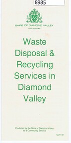 Greensborough Historical Society
Pamphlet - Pamphlet and document, Shire of Diamond Valley, Waste Disposal & Recycling Services in Diamond Valley, 01/02/1992
Shire of Diamond Valley Pamphlet and letter to Householders regarding the Kerbside Recycling Collection Services being implemented in 1993.Pamphlet, folder printed in green on buff paper; Letter to Householders, black text on white paper.shire of diamond vallety, recycling, waste management -
 Tarnagulla History Archive
Photograph of group of men, probably Shire of Bet Bet Council, circa 1920s, circa 1920s
Murray Comrie Collection. This photograph taken after the amalgamation with the Borough of Tarnagulla Council in 1915. Middle row, fourth from left is Walter (Wattie) Corrie, the Tarnagulla Baker, fourth from left is James Duggan, Tarnagulla Agent. Shire of Bet Bet Proclaimed Sept 20, 1864 Re-defined Feb 10, 1891 Tarnagulla Borough united Oct 1915 Dunolly Borough united Nov 1, 1921 Re subdivision from 5 to 3 ridings Oct 1952Monochrome photograph of a group of men assembled in rows for a photograph. No caption or explanation accompanies photograph. Probably depicts members of the Shire of Bet Bet Council in the 1920s. Location and names unknown. Walter Martin is sitting in the middle of the middle row. He was the Tarnagulla baker at the time of the photo. To the right of him in the photo is James Duggan, Tarnagulla dealer and agent. tarnagulla, council, bet bet shire, local government, councillors, mayor, shire -
 Eltham District Historical Society Inc
Photograph, Eltham Shire Office, shortly after duplication of Main Road, c.1968
Eltham Shire Council office built 1964 on the former site of Shillinglaw Cottage. In 1971 the offices were extended with a southern wing (to the left of the building) which housed the Eltham Library and planning offices. Taken shortly after widening of Main Road between Pitt Street and Elsa Court which was undertaken between February 1968 and August 1968. Image was most probably commissioned by Eltham Shire Council and taken by Hugh Fisher, photographer who operated from premises between Arthur and Dudely streets and was often contracted by the shire for official photographic work. The image was used in the August 1971 issue of Australian Municipal Journal This photo forms part of a collection of photographs gathered by the Shire of Eltham for their centenary project book,"Pioneers and Painters: 100 years of the Shire of Eltham" by Alan Marshall (1971). The collection of over 500 images is held in partnership between Eltham District Historical Society and Yarra Plenty Regional Library (Eltham Library) and is now formally known as the 'Shire of Eltham Pioneers Photograph Collection'. It is significant in being the first community sourced collection representing the places and people of the Shire's first one hundred years.Digital image and 120 format B&W negativesepp, shire of eltham pioneers photograph collection, eltham, main road, duplication, road widening, shillinglaw trees, local government -
 City of Greater Bendigo - Civic Collection
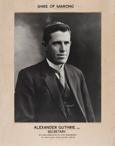
Photograph - Portrait of Alexander Guthrie, Alexander Guthrie / Secretary / Shire of Marong
c 1934 Commemorative mounted black and white portrait of Alexander Guthrie to remember his twenty eight years of service to the Shire of Marong.Shire of Marong / Alexander Guthrie ESQ / shire of marong, city of greater bendigo portraits, alexander guthrie -
 Marysville & District Historical Society
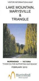
Map (Item) - Tourist map, Murrindindi Shire Council, VISITOR INFORMATION & MAP LAKE MOUNTAIN, MARYSVILLE & TRIANGLE, 02-2010
A visitor information map for Lake Mountain, Marysville and the local district produced by the Murrindindi Shire Council in February 2010. This information guide and map was produced after the 2009 Black Saturday bushfires destroyed most of the township of Marysville.A visitor information map for Lake Mountain, Marysville and the local district produced by the Murrindindi Shire Council in February 2010.Murrindindi Shire Council has made every effort to ensure the information provided at the time/ of printing is correct, but accepts no responsibility for an inaccuracies or omissions.lake mountain, marysville, victoria, australia, visitor information & map, murrindindi shire council, big 4 holiday park taggerty, black spur inn, black spur motel & caravan park, bush creek buddha, buxton hotel motel, cathedral valley farm, chestnut glade, crossways historic country inn, delderfield luxury b&b, kingbilli country estate, marapana agistment park & farm stay b&b, maryton park b&b, pinjarra gardens, sarsens rest, silverstream b&b, tower motel, willowbank at taggerty, wombat cottage, woodlands rainforest retreat, buxton general store and post office, buxton zoo nursery, cathedral view natural therapies, country touch, cross country ski hire, foodworks, highwood health retreat, lake mountain ski hire, lit & beyond, lj hooker, maroondah outdoor equipment/bait & tackle, marysville medical centre, marysville patisserie, marysville ski centre, marysville triangle real estate, marysville visitor information centre, mystic mountains ski hire/outdoors, pat's hairdressing, penni lanes country wares, plant's by shelian -
 Eltham District Historical Society Inc
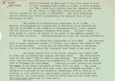
Document - Appendix, M.B. Watson, Shire Secretary, List of Former Road Board Chairmen and Shire Presidents (1856-1966), 28 Nov 1966
Appendix to Shire Secretary’s Report, 28 November 1966 SHIRE PRESIDENTS Local Government in this part of the State could be said to have commenced with election in 1846 of three trustees for "The Parish Road, leading from the Suburban Allotments in the Parish of Jika Jika, near Melbourne, to the Village Reserve in the Parish of Nillumbik". The Upper Heidelberg and Old Eltham Road follow approximately the original line of road proclaimed in 1840. The Eltham Road District was proclaimed on 24.9.1856. A meeting of landowners and householders of the Eltham Road District was held on 14.10.1856 at the Fountain of Friendship Hotel, Little Eltham, for the purpose of forming a District Road Board. To date I have been unable to locate any record of the names of the members elected, or of the first Chairman. Further research may yield the desired information. The Shire of Eltham was constituted on 28.3.1871. The proposed Roll of Shire Presidents should, I believe, also include the Road Board Chairmen. It may also be considered fitting to recognise the Heidelberg or Nillumbik (or Warringal) Road Trust in the same way. The first Minute Book of the Board, covering the period 1856 to 1863, has apparently been missing for many years. The Shire Minute Book for the period 1878 to 1885 is also missing. The absence of these vital records makes difficult the compilation of a complete and accurate list of Chairmen and Presidents. Although an early letter book yielded the names of the Shire Presidents in 1878, 1879 and 1800. The names prior to 1863 were derived from Rate Books and Government Gazettes. The information contained in the Municipal Directories 1875 to 1885 is at variance to some extent with such Council records as are available for that period, and consequently cannot be relied upon for the years where the Presidents names have not been shown. shire of eltham archives, series listing, a. armstrong, a. beale, a. brinkkotter, a. donaldson, a.h. price, a.j. braid, c.h. bath, c.m.a. pelling (mrs.), c.t. bell, d.c. o'beirne, e.d. butler, e.h. cameron, e.j. andrew, e.p. harmer, f.e. griffith, f.v. squire, f.w. nankervis, g. love, g. robertson, h. dendy, h. hewitt, h. stooke, l.t. wilmot, j. cox, j. murray, j. barr, j. bell, j. fitch, j. herbert, j. lawrey, j. mealy, j. pape, j. ryan, j. smedley, j.b. shallard, j.l. beale, l. c. docksey, r. mcadam, r.a. bell, r.c. white, r.r. woolcott, rutter, s.s. addison, s.w. scott, t. armstrong, t. irvine, w. horris, w. hubbard, w. lorimer, w. morris, w. taylor, w.c. farrell, w.f. ford, w.g. gray, w.h. bradbury, w.j. taylor, w.v. houghton -
 Eltham District Historical Society Inc
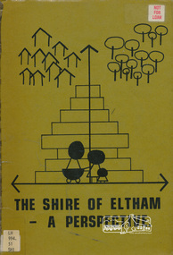
Book, Shire of Eltham, The Shire of Eltham - A Perspective, July 1981
This report was produced by the Shire of Eltham (Planning Department) following a population study of the Shire. It also includes other areas of general interest. The Document contents includes Present and Future - Population - Housing - Residential Lands - Social Characteristics - Development and History. Includes maps, tables and diagrams. Part 1: The Existing situation - introduction, the Shire of Eltham, physical characteristics, historical development, population growth. Characteristics of the population - size and distribution, age / sex, natural increase, migration. Socio-Economic Factors: socio-economic status, employment/workforce, education, other social factors. Housing/ building statistics: characteristics of Housing stock, current residential trends, other types of building activity. Residential Land: existing vacant lots, estimated additional lots. Part 2: The Future. Land availability, the future population.The Shire of Eltham Council resolved on publication of this report "to commend it to the ratepayers as a most valuable resource document". It provides a comprehensive statistical review of the Shire of Eltham, Victoria in 1981 with some population and development predictions for the future.Spiral bound, soft cover, includes indexBarcode and identification markings including stamped "WITHDRAWN" from Heidelberg Regional Library Serviceshire of eltham, planning, population -
 Greensborough Historical Society
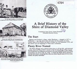
Article, Irene Turvey, A Brief history of the Shire of Diamond Valley, compiled by Irene Turvey, 1835o
Compiled by Irene Turvey, this brief history of the Shire of Diamond Valley is based on "The Diamond Valley Story" by Diane Edwards (published 1979), and includes photographs from the book.4 photocopied pages, text and photographsshire of diamond valley, diamond valley story -
 Tarnagulla History Archive
Photograph of Shire of Bet Bet Council, 1952, Shire of Bet Bet Council, 1952, 1952
Murray Comrie Collection. Shire of Bet Bet Proclaimed Sept 20, 1864 Re-defined Feb 10, 1891 Tarnagulla Borough united Oct 1915 Dunolly Borough united Nov 1, 1921 Re subdivision from 5 to 3 ridings Oct 1952Monochrome photograph of a group of men assembled in rows for a photograph. Accompanied by a handwritten note (catalogued separately as a Research Note) with subjects' names. Names of subjects from accompanying note (handwriting difficult to decipher) are believed to be: Left to Right Back/3rd row: Cr J. Grogan, A. Whitehead, G. Barman, J.B. Reid, I.R. Stevens (?), KAG Lowe (Shire Sec), Mr A Rescott (Maryborough Advertiser) Middle row: Crs N.K. Conera (Pres. Elect), D.E. Wood, A. Brownbill, J.P. Mason, D. Clark, K.R. Culleton (Shire Engineer). Front/1st row: Crs G. Fotheringham, J. Fremantle (1951-52), A. Green, J. Hickey. Note also states: 'Secretary Lowe passed away Sept 7, 1952' and 'Fotheringham House, Glenferrie' (location where photograph taken?)tarnagulla, council, bet bet shire, local government, councillors, mayor, shire, engineer, maryborough advertiser, reid, grogan, whitehead, barman, stevens, lowe, rescott, conera, wood, brownbill, mason, clark, culleton, fotheringham, fremantle, green, hickey -
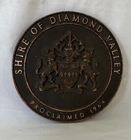 Greensborough Historical Society
Plaque, Shire of Diamond Valley, Shire of Diamond Valley, Proclaimed 1964 Plaque, 1960s
This Logo was from the front door of the original Diamond Valley Library under Shire of Diamond Valley offices, Civic Ave, Greensborough. This was before the current Diamond Valley branch was built.Round brass plaque with writing and logoshire of diamond valley, plaques, diamond valley library -
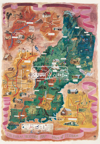 Eltham District Historical Society Inc
Map (item), Megan Evans, Cultural Heritage Map, Shire of Eltham, 1993
Copy of artist's map of the Shire of Eltham with numerous historical and cultural places of interest illustrated and notated including evidence of original Wurundjeri occupation and local flora and fauna. The original watercolour is held in the Nillumbik Shire Council Civic Collection. "Evans remembers being surprised they had asked an artist to create this map rather than a designer. Originally made as a watercolour, the map was later made into posters and adorned many homes around the area. The map creatively interprets the town and provides a wayfinding to both cultural and historical points in the area." Nillumbik Arts News December 2023. artist, buildings, cultural heritage map, fauna, flora, map, megan evans, shire of eltham, wurundjeri -
 City of Greater Bendigo - Civic Collection
Photograph - Councillor group portrait, W H Robinson, Strathfieldsaye Shire Council, 1909
The district of Strathfieldsaye was proclaimed in 1861 and named a Shire on the 17th September in 1866. It remained a shire until amalgamation in 1994 when it became part of the City of Greater Bendigo. The shire was located 8 km to the south- east of Bendigo and covered an area of 601 square kilometres and extended from the Calder Highway to the Coliban and Campaspe Rivers. The shire's administration centre was in Strathfieldsaye until 1972 when new offices were opened in Kennington.Photographic group portrait of eleven Strathfieldsaye Shire Councillors in front of the Strathfieldsaye Shire Hall. Five men are seated and six standing with one man standing further in back ground on the building's verandah. Photograph is attached directly to green mount card and framed. Gold lettering on mount.Strathfieldsaye Shire Councillors / R. B. Brennan (Sec.) W. J. Lowdes S. Doak M. Burns () N Condon B. Code (Inspector) / WH Robinson Photo Bendigo / T Somerville / W. I. Long / Fred Osborne (President) H Keck / W Dresler / With the President's (Cr. Fred Osborne) Compliments / September 23rd, 1909shire of strathfieldsaye, strathfieldsaye shire council, president of strathfieldsaye shire, strathfieldsaye shire hall -
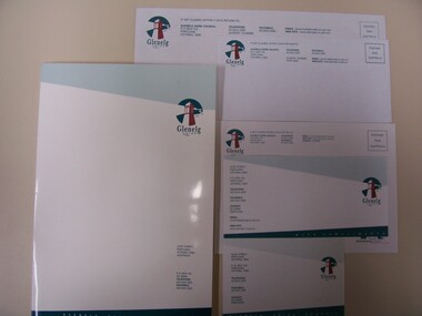 Glenelg Shire Council Cultural Collection
Functional object - Compliments slip, 1995
In use by Council 1995 - March 2006With compliments slip with watermark "Australis". Glenelg Shire Council.Front: Glenelg Shire Council (GSC) logo and contact details Back: (no inscriptions)glenelg shire council, stationery, compliments slip, 1995, 1990s -
 Eltham District Historical Society Inc
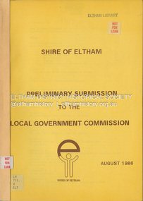
Document, Shire of Eltham, Shire of Eltham Preliminary submission to the Local Government Commission, August 1986
Report produced by the Shire of Eltham in August 1986 as a prelimary response to proposed municipal restructure in the state of Victorianon-fictionReport produced by the Shire of Eltham in August 1986 as a prelimary response to proposed municipal restructure in the state of Victoriacouncil amalgamation, annexation, rates -
 Stawell Historical Society Inc
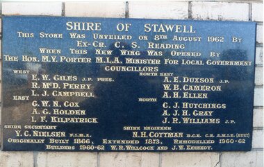
Photograph, Stawell Shire Hall 1866 -- 04 Photos -- Coloured
Shire Hall 4 Colour photos. Three photos (84.10a, b, c,) showing the brick veneer addition to the Stawell Shire Hall. One photo (84.10) of the plaque bearing the councillors names. These photos were taken in 2013 and each photo shows a different view of the brick veneer addition. One view is the front of the brick addition and other 2 are of the rear view of the 1962 addition.Four colour Photographs. Three of the brick additions to the Stawell Shire Hall in 1960-1962. One photograph of the plaque bearing the councillors names.Shire of Stawell. This stone was unveiled on 8th August 1962 by Ex. Cr. C. S. Reading When this new wing was opened by the Hon. M.V. Porter M.L.A. Minster for Local Government. Councillors WEST - E. W. Giles J.P. Pres., R. McD. Perry., L. J. Campbell., EAST - G. W. N. Cox., A. G. Holden., I.F. Kilpatrick., NORTH EAST - A. E. Duxson J.P., W.B. Cameron., A.H. Ellen., NORTH - C.J. Hutchings., A. J. H. Gray., J. R. Williams J.P., Shire secretary V. C. Neilson F.I.M.A. Shire Engineer N. H. Cottman B.C.E. C.E. A.M.I.E (Aust) Originally Built 1866. Extended 1873. Remodelled 1960-62 Builders 1960-62 W.R. Willcock and J.W. Kennedy.stawell -
 Linton and District Historical Society Inc
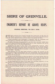
Report, Shire of Grenville, Engineer's Report re Gravel Heaps, 7th July 1916
Single sheet approximately A4 in size, folded to form four pages. Three-page report prepared by M. Martin, Shire Engineer, detailing the advisability of and legal basis for the Shire of Grenville retaining control of various quartz and tailing heaps (remnants of mining) located throughout the Shire.Text: " SHIRE OF GRENVILLE. / ENGINEER'S REPORT RE GRAVEL HEAPS. / COUNCIL MEETING, 7th JULY, 1916. "shire of grenville, gravel heaps, mining, roads -
 Greensborough Historical Society
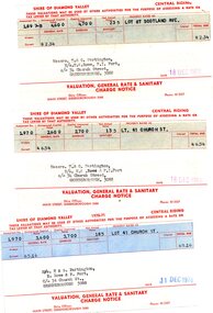
Financial record - Account, Shire of Diamond Valley, Shire of Diamond Valley rates notices 1969-1970, 26/03/1958
3 Shire of Diamond Valley Rates assessments issued jointly to Trevor and Gary Partington and their sisters, Mrs Elinor Rowe and Mrs Faye Fort. The locations of the land are Lot 41 Church Street and Lot 67 Scotland Avenue Greensborough. It is possible that this land was purchased by Alan Partington in his adult children's names.Part of the property owned by the Partington family in the original Greensborough farmland. 3 Rates notices, printed in red text with black typed details.Date stamped with rubber stampalan partington, william alan partington, partington family, land deals greensborough, church street greensborough, scotland avenue greensborough -
 City of Greater Bendigo - Civic Collection
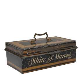
Functional object, Shire of Marong, Unknown
The first local government authority for Marong was the Marong Road District (an early form of single-purpose local government), which was proclaimed on 19 August 1860. Its boundary was altered twice in 1862 and on 12 December 1864 it was re designated as a shire. It absorbed Raywood Borough in 1915, and was proclaimed a Rural City in 1990. On 2 December 1994, with the creation of Greater Bendigo City Council, it was abolished by being amalgamated with Bendigo City, Eaglehawk Borough, Huntly Shire, part of McIvor Shire, part of Metcalfe Shire and Strathfieldsaye Shire to form Greater Bendigo City.Painted metal tin with handle on top. Currently locked closed.Shire of Marongshire of marong -
 Rutherglen Historical Society
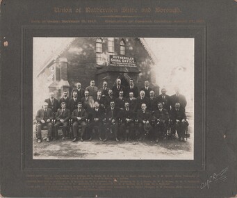
Photograph - Image, Alf L. Bowden, The Studio, Union of Rutherglen Shire and Borough, 1921
The building is the old Shire Hall (formerly a Church) in High Street. Roy Ready Senior bought the land and building and built his house with it as a part.Black and white photograph, mounted on cardboard, of a number of men in front of a building labelled Rutherglen Shire Office. Printed at top of mount: "Union of Rutherglen Shire and Borough | Date of Union: December 15, 1920. dissolution of Combined Councils: August 25, 1921." Complete list of individual names printed at bottom of mount. At bottom right of mount: "Alf L Bowden, The Studio, Corowa, N.S.W." Note from donor pasted on back of mount.rutherglen shire, rutherglen borough, shire buildings, rutherglen shire councillors, roy ready