Showing 218 items
matching iron stone
-
 Villa Alba Museum
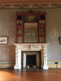
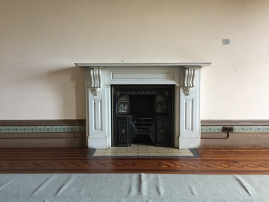
Decorative object - Drawing Room Fireplace, Villa Alba, c.1882
The Villa Alba Museum is cultural institution committed to the collection, study and display of 19th century interior decorative finishes, and the components of 19th and 20th century interior decoration. Most rooms in this historically and aesthetically significant house have stone (typically marble) fireplaces that are inset with decorative tiles produced by the company of Mintons Ltd in the United Kingdom.Digital photograph of an intact and original 1880s fireplace in the drawing room of Villa Alba. Carved white marble mantle surround. Iron and brass back panel. Cast iron insert. Plain and decorative surround and hearth tiles produced by Mintons Ltd.fireplaces, villa alba - drawing room, mintons, mintons - tiles -
 Villa Alba Museum
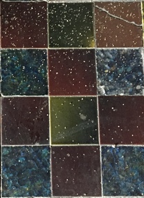
Photograph - Hearth Tiles, Dining Room Fireplace, Villa Alba, Mintons Ltd, c.1882
The Villa Alba Museum is cultural institution committed to the collection, study and display of 19th century interior decorative finishes, and the components of 19th and 20th century interior decoration. Most rooms in this historically and aesthetically significant house have stone (typically marble) fireplaces that are inset with plain and decorative tiles produced by the company of Mintons Ltd.Digital photograph of the pattern of plain hearth tiles in the fireplace of the dining room at Villa Alba. The square majolica plain tiles, positioned under where the original cast iron grill sat, are in shades of brown, green and blue. The tiles were produced by Mintons Ltd.fireplaces, mintons, mintons - tiles, villa alba -- dining room -
 Villa Alba Museum
Photograph - Morning Room Fireplace, Villa Alba, c.1882
The Villa Alba Museum is cultural institution committed to the collection, study and display of 19th century interior decorative finishes, and the components of 19th and 20th century interior decoration. Most rooms in this historically and aesthetically significant house have stone (typically marble) fireplaces that are inset with plain and decorative tiles produced by the company of Mintons Ltd.Digital photograph of the fireplace in the ground floor morning room of Villa Alba. The original 1880s black marble mantel surround is missing its decorative surround tiles and cast iron hearth but retains its decorative hearth tiles produced by Mintons Ltd.fireplaces, mintons, mintons - tiles, villa alba -- morning room -
 Villa Alba Museum
Photograph - Morning Room Fireplace, Villa Alba, c.1882
The Villa Alba Museum is cultural institution committed to the collection, study and display of 19th century interior decorative finishes, and the components of 19th and 20th century interior decoration. Most rooms in this historically and aesthetically significant house have stone (typically marble) fireplaces that are inset with plain and decorative tiles produced by the company of Mintons Ltd.Digital photograph of the fireplace in the ground floor morning room of Villa Alba. The original 1880s black marble mantel surround is missing its decorative surround tiles and cast iron hearth but retains its decorative hearth tiles produced by Mintons Ltd. The fireplace was modified in the 1950s when it was used as a home for nurses of the Royal Women's Hospital. fireplaces, mintons, mintons - tiles, villa alba -- morning room -
 Villa Alba Museum
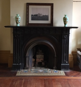
Photograph - Main Bedroom Fireplace, Villa Alba, c.1882
The Villa Alba Museum is cultural institution committed to the collection, study and display of 19th century interior decorative finishes, and the components of 19th and 20th century interior decoration. Most rooms in this historically and aesthetically significant house have stone (typically marble) fireplaces that are inset with plain and decorative tiles produced by the company of Mintons Ltd.Born digital photograph of the fireplace in the main bedroom of Villa Alba. The original 1880s white marble mantel surround has a raised iron and brass cast iron grate with hearth and side tiles by Mintons Ltd. The marble fire surround has being carved in a conventional style and lacks the opulence of what was at the time described as the grandest bedroom in the Colony, whereas the raised grate features decorative brass sun symbols and scrolling on the iron panels. The 'grey monochrome' surround tiles, of which there are eight in situ were produced to design by John Moyr Smith by Mintons Ltd as part of the 'Waverley' series (No, 1607) of which there were twelve subjects (Mintons Catalogue, p. 62/206). The selection conforms to William Greenlaw's desire to symbolically represent Scottish themes in the decoration of the house. It also relates to the mural in the dining room architrave of scenes from the novels of Sir Walter Scott. The three rows of hearth tiles employ a repeated geometric pattern.fireplaces, mintons, mintons - tiles, villa alba - main bedroom -
 Hume City Civic Collection
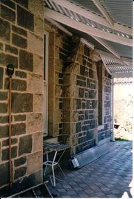
Photograph, Late 1980's
'Dunhelen' is situated on the Mickleham Road at Greenvale. The rear of the homestead was constructed in the 1850's and the original owners were Richard and George Sinclair Brodie who emigrated from Scotland.A coloured photograph of part of a porchway of a house. The verandah roof is constructed from wooden beams and corrugated iron. The walls are bluestone with granite stone quions around the corners and window frames. The verandah was paved with stone pavers done in a diamond pattern.dunhelen, brodie, george sinclair, richard sinclair, george evans collection -
 Hume City Civic Collection
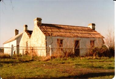
Photograph
This is a photograph of one of the many stone ruins of buildings which can be seen in the Sunbury district and surrounding areas. This series of 13 photographs show various views of one of the remaining uninhabited stone cottages which were built in the early days of the district's settlement.A coloured photograph of a stone cottage with a wooden shingle roof and its weatherboard and corrugated iron out building. A valley between two sections of the building suggests it has been built in stages. Three chimneys are visible and the cottage has three 12 paned sash windows with a doorway in the centre of the front. There is a cyclone wire fence and gate across the front and the garden is overgrown.stone structures, shingle roofs, george evans collection -
 Hume City Civic Collection
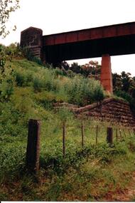
Photograph, c late 1980s
The series of photographs show a number of sites included in the Rupertswood Estate. By 1851 William Clarke had acquired 31,375 acres of land in the Sunbury district. The foundation stone for Rupertswood Mansion was laid on 29th August 1874 by Mrs. W. J. Clarke, daughter-in-law of 'Big Bull'. The Salesian Fathers bought the Rupertswood property in June 1927 and established Salesian College.A coloured photograph of the bluestone and iron rail bridge over the Jacksons Creek on the Rupertswood Estate. One stone pylon at the top of the embankment and an iron pylon are visible along with the stone wall at the base of the embankment and part of the iron span. A post and wire fence is in the foreground.rupertswood estate, clarke, william j. t. 'big bull', salesian brothers, george evans collection -
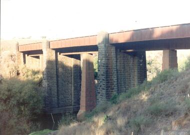 Hume City Civic Collection
Photograph, late 1990s
The bridge constructed from bluestone, brick and iron over the Jacksons Creek at Sunbury is an important structure on the Melbourne-Echuca rail line. The foundation stone for the bridge was laid on 13 January 1859 and the bridge opened in July 1861. It is of state significance.A coloured photograph of the bluestone and iron railway bridge which is ove the Jacksons Creek. The bridge has 3 bluestone pylons and three iron pylons with 3 sections of the iron spans visible across the top.transport, bridges, rail transport, darbyshire, g. c., jacksons creek, george evans collection -
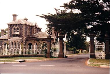 Hume City Civic Collection
Photograph, early 1990s
The Rupertswood Gatehouse, iron fence and gates are of state historical and architectural importance as they are probably the most distinctive structures of their type in Victoria.A coloured photograph of the Rupertswood Lodge, iron fence and gates. At the gateway there are double gates and two single gates on either side. The four gateposts are stone with a decorative finish on the top. The double gates are open so the roadway into the Rupertswood estate is visible.clarke, william john (sir), rupertswood gatehouse, salesian college, george evans collection -
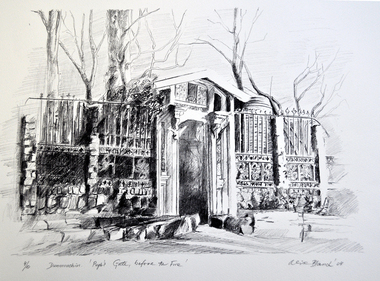 Nillumbik Shire Council
Print (Lithograph) Alice Blanch CHEHOVSKI, Alice B. (Blanch) Chehovski, Dunmoochin. Pugh's Gate, before the Fire, / Printed 2004
... stone and wrought iron (open) gate/ entrance to Pugh's artist... and white lithograph on paper depicting the elaborate stone ...Alice Blanch Chehovski was born in Queensland to a Russian mother and Polish father. When her father died leaving three small children to bring up on her own, her took them back to Russia to visit her own parents. In the following fateful year, Stalin came into power and the family was trapped by Russia closing its borders. At the age of twenty three, 1944, Alice entered Moscow's Institute of Decorative Arts and Applied Arts to study ceramics. Neither the subject of ceramics nor the academic drawing in fine pencil inspired her. At that time Moscow was surrounded by German troops, Russian culture was inhibited by the war and generally speaking it was not the time for arts. Alice said 'My soul and my hands were needed as a volunteer, to help the wounded soldiers survive'. Alice struggled through a lifetime of hardship and triumph before returning to her native land of Australia in 1981 at the age of 60.This lithographic print is one of a set of ten produced at Dunmoochin at the time of Clifton Pugh.Black and white lithograph on paper depicting the elaborate stone and wrought iron (open) gate/ entrance to Pugh's artist colony 'Dunmoochin' situated at Cottles Bridge. Bottom left of print: ed. no. '4/10' and work title. Bottom right of print: artist signature 'Alice Blanch '04'chehovski, dunmoochin, pugh, gate, fire, lithograph -
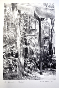 Nillumbik Shire Council
Print (Lithograph) Alice Blanch CHEHOVSKI, Alice B. (Blanch) Chehovski, Dunmoochin, Sunlight, / Printed 2004
... stone and wrought iron (open) gate/ entrance to Pugh's artist... and white lithograph on paper depicting the elaborate stone ...Alice Blanch Chehovski was born in Queensland to a Russian mother and Polish father. When her father died leaving three small children to bring up on her own, her took them back to Russia to visit her own parents. In the following fateful year, Stalin came into power and the family was trapped by Russia closing its borders. At the age of twenty three, 1944, Alice entered Moscow's Institute of Decorative Arts and Applied Arts to study ceramics. Neither the subject of ceramics nor the academic drawing in fine pencil inspired her. At that time Moscow was surrounded by German troops, Russian culture was inhibited by the war and generally speaking it was not the time for arts. Alice said 'My soul and my hands were needed as a volunteer, to help the wounded soldiers survive'. Alice struggled through a lifetime of hardship and triumph before returning to her native land of Australia in 1981 at the age of 60.This lithographic print is one of a set of ten produced at Dunmoochin at the time of Clifton Pugh.Black and white lithograph on paper depicting the elaborate stone and wrought iron (open) gate/ entrance to Pugh's artist colony 'Dunmoochin' situated at Cottles Bridge.Bottom left of print: ed. no. '4/10' and work title. Bottom right of print: artist signature 'Alice Blanch '04'chehovski, dunmoochin, pugh, sunlight, lithograph -
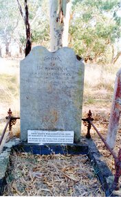 Stawell Historical Society Inc
Photograph, Charles Creswick's Grave
At THe Base of the Headstone is another Stone which reads "This graves was renovated 1922 by residents of surrounding disctricts." IN MEMORY OF THE FIRST WHITE SETTLER IN THE WIMMERA WHO DIED HERE.2 Colour Photgraphs: 7097 Charles Creswicks Grave and Headstone, with iron Border 7097a A Closeup of thetop portion of teh Headstones showing the inscription.Sacred to the Memory of Charles Creswick who departrf this life May the 4th 1847 Aged 28 Yearscharles creswick -
 Stawell Historical Society Inc
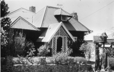
Photograph, Log Cabin c 1930's with Iron roof
... with a lattice porch way, stone chimney's and iron roof. On the iron roof... the Log cabin had a bark roof. The roof was replaced with iron ...Log Cabin built by Mr. J. Wharrie c 1930’s. Originally the Log cabin had a bark roof. The roof was replaced with iron. The home is located in Darlington Road Stawell. The Wharrie family lived in the cabin for many years during the 1940's and owned a doll factory. Black & white photograph depicting a home built of logs with a lattice porch way, stone chimney's and iron roof. On the iron roof is a weather vane decorated on top by a carriage and 2 horses. The house is set in a garden with a stone fence in the foreground. There are 2 black & white prints one an enlargement of the smaller photograph.stawell dwelling -
 Torquay and District Historical Society
Photograph (copy), Bellbrae Cemetery Memorial Exhibition 2015
Photograph shows Llanberris House, built by Joseph and Mary Gundry on Iron Bark Station, west of the Anglesea Geelong Road, off Menzels Road above Spring Creek. The Gundrys took up Iron Bark station in 1844 and subsequently bought up more surrounding land. Just prior to Joseph's death in 1878, the property comprising 7721 acres was offered for sale as well as conditional rights to adjoining land. Llanberis House was a substantial stone dwelling of 2 storeys with 11 rooms.The Gundry family was one of the pioneering European settlers in the Bellbrae Torquay area.Black and white photographbellbrae victoria pioneer families -
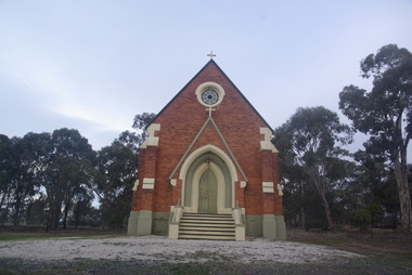
 Ballarat Heritage Services
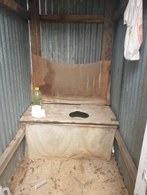
Photograph - Photograph - Colour, Clare Gervasoni, Toilet at St Laurence O'Toole Catholic Church, Sandon, 2017, 08/04/2023
St Laurence O'Toole church and cemetery is located in a rural setting at 801/821 Creswick-Newstead Rd, Sandon. Originally a small wooden school (22’x14’) was erected in Sandon by Father Patrick Smyth (who was involved in the Eureka Stockade movement) in 1859. It was also used for Mass and became known as a chapel. In June 1882 tenders were called for the construction of a brick Church by the Castlemaine architect, T.F. Kibble, and it was built at a cost of 1000 pounds. The church was blessed by Archbishop Goold on 06 May 1883 and dedicated to St Laurence O'Toole. The brick building demonstrates original design qualities of a Victorian Rudimentary Gothic style, including the steeply pitched, parapet gable roof form, together with a central steeply pitched, gabled porch that projects slightly from the main gable end. Other intact qualities include the exposed brick wall construction, lapped galvanised corrugated iron roof cladding, minor gabled porch at the rear, small ventilation dormers nearby the roof ridgeline, series of stone steps that lead to the central porch with its double pointed door opening and vertical boarded doors, simple rose window in the main gable end, pointed windows, brick buttresses with double lower copings, and the light masonry detailing (the banding marking the floor level within, buttress copings, window and door surrounds and quoins, and the drip moulds).(Shire of Mount Alexander: Heritage Study of the former Shire of Newstead, 2000) The visually connected cemetery demonstrates important visual qualities formed by the regular rows of graves and cemetery architecture, and the grassed and treed rural landscape. It is a rare and substantially intact example of a Victorian Catholic Church with a cemetery in its churchyard. Many headstones and cemetery architecture, date from the 19th century and represent some fine examples of masonry craftsmanship. Some refurbisments occurred during the 1940s and in 2002 a major restoration project was undertaken from roof to footings, by a dedicated band of volunteers and trades people. Work was completed mid 2003 and in November 2003 St Laurence’s was re-dedicated with the celebration of Mass and a picnic tea. Colour photograph of a long drop toliet at the Catholic Church, Sandon, Victoria.sandon, sandon cemetery, st laurence o'toole catholic church, sandon -
 Ballarat Heritage Services
Photograph - Colour, Clare Gervasoni, Armytage House, Geelong, 2019, 24/03/2019
... - tender for iron gates 15 October 1860 - tender for stone wall... - tender for iron gates 15 October 1860 - tender for stone wall ...'Armytage House' formerly 'The Hermitage' a two storey Barrabool freestone ashlar and basalt rubble mansion was upon completion in 1860 one the finest colonial regency style mansion houses in Victoria. The Ionic portico and exquisitely proportioned, encircling wrought iron verandah is the most distinctive feature of this mansion, which is undoubtedly Edward Prowse's most impressive work. The mansion has considerable and important historical associations, firstly with the Armytage family, and finally with the Geelong C.E.G.G.S (1905-1973) (https://vhd.heritagecouncil.vic.gov.au/places/21747/download-report, accessed 25/03/2019) 03 May 1858 - Tender Notice in Geelong Advertiser 27 April 1860 - tender for iron gates 15 October 1860 - tender for stone wall and iron railing.armytage, armytage house, geelong, edward prowse, barrabook freestone, the hermitage -
 Ballarat Heritage Services
Photograph - Photograph - Colour, Lisa Gervasoni, St Laurence O'Toole Catholic Church, Sandon, 2017, 16/07/2017
St Laurence O'Toole church and cemetery is located in a rural setting at 801/821 Creswick-Newstead Rd, Sandon. Originally a small wooden school (22’x14’) was erected in Sandon by Father Patrick Smyth (who was involved in the Eureka Stockade movement) in 1859. It was also used for Mass and became known as a chapel. In June 1882 tenders were called for the construction of a brick Church by the Castlemaine architect, T.F. Kibble, and it was built at a cost of 1000 pounds. The church was blessed by Archbishop Goold on 06 May 1883 and dedicated to St Laurence O'Toole. The brick building demonstrates original design qualities of a Victorian Rudimentary Gothic style, including the steeply pitched, parapet gable roof form, together with a central steeply pitched, gabled porch that projects slightly from the main gable end. Other intact qualities include the exposed brick wall construction, lapped galvanised corrugated iron roof cladding, minor gabled porch at the rear, small ventilation dormers nearby the roof ridgeline, series of stone steps that lead to the central porch with its double pointed door opening and vertical boarded doors, simple rose window in the main gable end, pointed windows, brick buttresses with double lower copings, and the light masonry detailing (the banding marking the floor level within, buttress copings, window and door surrounds and quoins, and the drip moulds).(Shire of Mount Alexander: Heritage Study of the former Shire of Newstead, 2000) The visually connected cemetery demonstrates important visual qualities formed by the regular rows of graves and cemetery architecture, and the grassed and treed rural landscape. It is a rare and substantially intact example of a Victorian Catholic Church with a cemetery in its churchyard. Many headstones and cemetery architecture, date from the 19th century and represent some fine examples of masonry craftsmanship. Some refurbisments occurred during the 1940s and in 2002 a major restoration project was undertaken from roof to footings, by a dedicated band of volunteers and trades people. Work was completed mid 2003 and in November 2003 St Laurence’s was re-dedicated with the celebration of Mass and a picnic tea. Colour photograph of a brick church at Sandon, Victoria.sandon, sandon cemetery, st laurence o'toole catholic church, sandon -
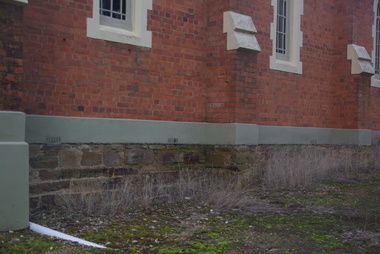 Ballarat Heritage Services
Photograph - Photograph - Colour, Clare Gervasoni, Sandstone foundations at St Laurence O'Toole Catholic Church, Sandon, 2017, 16/07/2017
St Laurence O'Toole church and cemetery is located in a rural setting at 801/821 Creswick-Newstead Rd, Sandon. Originally a small wooden school (22’x14’) was erected in Sandon by Father Patrick Smyth (who was involved in the Eureka Stockade movement) in 1859. It was also used for Mass and became known as a chapel. In June 1882 tenders were called for the construction of a brick Church by the Castlemaine architect, T.F. Kibble, and it was built at a cost of 1000 pounds. The church was blessed by Archbishop Goold on 06 May 1883 and dedicated to St Laurence O'Toole. The brick building demonstrates original design qualities of a Victorian Rudimentary Gothic style, including the steeply pitched, parapet gable roof form, together with a central steeply pitched, gabled porch that projects slightly from the main gable end. Other intact qualities include the exposed brick wall construction, lapped galvanised corrugated iron roof cladding, minor gabled porch at the rear, small ventilation dormers nearby the roof ridgeline, series of stone steps that lead to the central porch with its double pointed door opening and vertical boarded doors, simple rose window in the main gable end, pointed windows, brick buttresses with double lower copings, and the light masonry detailing (the banding marking the floor level within, buttress copings, window and door surrounds and quoins, and the drip moulds).(Shire of Mount Alexander: Heritage Study of the former Shire of Newstead, 2000) The visually connected cemetery demonstrates important visual qualities formed by the regular rows of graves and cemetery architecture, and the grassed and treed rural landscape. It is a rare and substantially intact example of a Victorian Catholic Church with a cemetery in its churchyard. Many headstones and cemetery architecture, date from the 19th century and represent some fine examples of masonry craftsmanship. Some refurbisments occurred during the 1940s and in 2002 a major restoration project was undertaken from roof to footings, by a dedicated band of volunteers and trades people. Work was completed mid 2003 and in November 2003 St Laurence’s was re-dedicated with the celebration of Mass and a picnic tea. Details of the exterior of St Laurence O'Toole Catholic Church, Sandon in Central Victoria.sandon, sandon cemetery, st laurence o'toole catholic church, sandon, sandstone, foundations -
 Ballarat Heritage Services
Photograph - Photograph - Colour, Clare Gervasoni, St Laurence O'Toole Catholic Church, Sandon, 2017, 16/07/2017
St Laurence O'Toole church and cemetery is located in a rural setting at 801/821 Creswick-Newstead Rd, Sandon. Originally a small wooden school (22’x14’) was erected in Sandon by Father Patrick Smyth (who was involved in the Eureka Stockade movement) in 1859. It was also used for Mass and became known as a chapel. In June 1882 tenders were called for the construction of a brick Church by the Castlemaine architect, T.F. Kibble, and it was built at a cost of 1000 pounds. The church was blessed by Archbishop Goold on 06 May 1883 and dedicated to St Laurence O'Toole. The brick building demonstrates original design qualities of a Victorian Rudimentary Gothic style, including the steeply pitched, parapet gable roof form, together with a central steeply pitched, gabled porch that projects slightly from the main gable end. Other intact qualities include the exposed brick wall construction, lapped galvanised corrugated iron roof cladding, minor gabled porch at the rear, small ventilation dormers nearby the roof ridgeline, series of stone steps that lead to the central porch with its double pointed door opening and vertical boarded doors, simple rose window in the main gable end, pointed windows, brick buttresses with double lower copings, and the light masonry detailing (the banding marking the floor level within, buttress copings, window and door surrounds and quoins, and the drip moulds).(Shire of Mount Alexander: Heritage Study of the former Shire of Newstead, 2000) The visually connected cemetery demonstrates important visual qualities formed by the regular rows of graves and cemetery architecture, and the grassed and treed rural landscape. It is a rare and substantially intact example of a Victorian Catholic Church with a cemetery in its churchyard. Many headstones and cemetery architecture, date from the 19th century and represent some fine examples of masonry craftsmanship. Some refurbisments occurred during the 1940s and in 2002 a major restoration project was undertaken from roof to footings, by a dedicated band of volunteers and trades people. Work was completed mid 2003 and in November 2003 St Laurence’s was re-dedicated with the celebration of Mass and a picnic tea. Brick church at Sandon, Victoriasandon, sandon cemetery, st laurence o'toole catholic church, sandon -
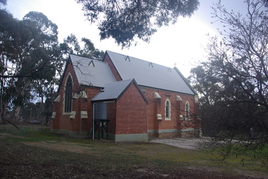
 Ballarat Heritage Services
Photograph, Clare Gervasoni, St Laurence O'Toole Catholic Church, Sandon, 2017, 16/07/2017
St Laurence O'Toole church and cemetery is located in a rural setting at 801/821 Creswick-Newstead Rd, Sandon. Originally a small wooden school (22’x14’) was erected in Sandon by Father Patrick Smyth (who was involved in the Eureka Stockade movement) in 1859. It was also used for Mass and became known as a chapel. In June 1882 tenders were called for the construction of a brick Church by the Castlemaine architect, T.F. Kibble, and it was built at a cost of 1000 pounds. The church was blessed by Archbishop Goold on 06 May 1883 and dedicated to St Laurence O'Toole. The brick building demonstrates original design qualities of a Victorian Rudimentary Gothic style, including the steeply pitched, parapet gable roof form, together with a central steeply pitched, gabled porch that projects slightly from the main gable end. Other intact qualities include the exposed brick wall construction, lapped galvanised corrugated iron roof cladding, minor gabled porch at the rear, small ventilation dormers nearby the roof ridgeline, series of stone steps that lead to the central porch with its double pointed door opening and vertical boarded doors, simple rose window in the main gable end, pointed windows, brick buttresses with double lower copings, and the light masonry detailing (the banding marking the floor level within, buttress copings, window and door surrounds and quoins, and the drip moulds).(Shire of Mount Alexander: Heritage Study of the former Shire of Newstead, 2000) The visually connected cemetery demonstrates important visual qualities formed by the regular rows of graves and cemetery architecture, and the grassed and treed rural landscape. It is a rare and substantially intact example of a Victorian Catholic Church with a cemetery in its churchyard. Many headstones and cemetery architecture, date from the 19th century and represent some fine examples of masonry craftsmanship. Some refurbisments occurred during the 1940s and in 2002 a major restoration project was undertaken from roof to footings, by a dedicated band of volunteers and trades people. Work was completed mid 2003 and in November 2003 St Laurence’s was re-dedicated with the celebration of Mass and a picnic tea. Colour photograph of a red brick church in Sandon. sandon, sandon cemetery, st laurence o'toole catholic church, sandon -
 Ballarat Heritage Services
Photograph - Photograph - Colour, Clare Gervasoni, Treed road behind St Laurence O'Toole Catholic Church, Sandon, 2017, 16/07/2017
St Laurence O'Toole church and cemetery is located in a rural setting at 801/821 Creswick-Newstead Rd, Sandon. Originally a small wooden school (22’x14’) was erected in Sandon by Father Patrick Smyth (who was involved in the Eureka Stockade movement) in 1859. It was also used for Mass and became known as a chapel. In June 1882 tenders were called for the construction of a brick Church by the Castlemaine architect, T.F. Kibble, and it was built at a cost of 1000 pounds. The church was blessed by Archbishop Goold on 06 May 1883 and dedicated to St Laurence O'Toole. The brick building demonstrates original design qualities of a Victorian Rudimentary Gothic style, including the steeply pitched, parapet gable roof form, together with a central steeply pitched, gabled porch that projects slightly from the main gable end. Other intact qualities include the exposed brick wall construction, lapped galvanised corrugated iron roof cladding, minor gabled porch at the rear, small ventilation dormers nearby the roof ridgeline, series of stone steps that lead to the central porch with its double pointed door opening and vertical boarded doors, simple rose window in the main gable end, pointed windows, brick buttresses with double lower copings, and the light masonry detailing (the banding marking the floor level within, buttress copings, window and door surrounds and quoins, and the drip moulds).(Shire of Mount Alexander: Heritage Study of the former Shire of Newstead, 2000) The visually connected cemetery demonstrates important visual qualities formed by the regular rows of graves and cemetery architecture, and the grassed and treed rural landscape. It is a rare and substantially intact example of a Victorian Catholic Church with a cemetery in its churchyard. Many headstones and cemetery architecture, date from the 19th century and represent some fine examples of masonry craftsmanship. Some refurbisments occurred during the 1940s and in 2002 a major restoration project was undertaken from roof to footings, by a dedicated band of volunteers and trades people. Work was completed mid 2003 and in November 2003 St Laurence’s was re-dedicated with the celebration of Mass and a picnic tea. Colour photograph of bushland behind a church at Sandon, Victoria.sandon, sandon cemetery, st laurence o'toole catholic church, sandon, landscape, road -
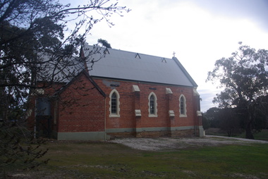
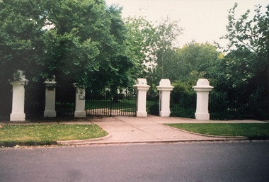
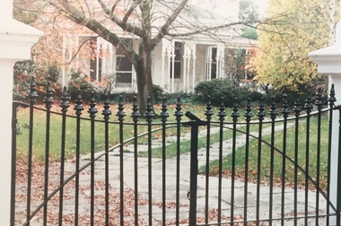
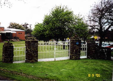 Hume City Civic Collection
Photograph, St. Andrews Uniting Church gates, 8th September 2001
These are the original wrought iron gates which served as the entrance to St. Andrews Uniting Church, formerly St.Andrews Presbyterian Church. They were erected there in 1922 and were made at H.V.McKay's Sunshine Harvester foundry, at Sunshine. H.V McKay was a member of the Presbyterian Church in Sunbury. Originally the gates opened onto Stawell Street, which ran at an angle between O'Shanassy and Barkly Streets. Apart from a small area leading to the Memorial Hall the rest of Stawell Street has been incorporated in the Village Green in Sunbury.The gates were restored and erected on their original site in 2000. A scanned coloured photograph of white painted wrought iron double gates with two smaller gates on either side and supported by stone pillars. A church building is just beyond a grassed area.st. andrews church, st. andrew's uniting church, wrought iron gates -
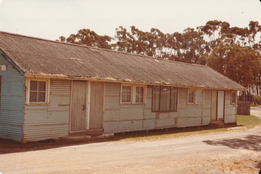 Tatura Irrigation & Wartime Camps Museum
Photograph - Army Hut
Army Hut that was used at the Tatura Racecourse after the war. The gumtree plantation was plated by Tatura Primary School students.Long Grey corrugated iron hut with corrugated iron roof. Six wood framed windows painted white and one black framed possibly aluminium window in centre of the hut. Four wooden doors with stone steps. A row of gumtree behind the hut. Lawn and gravel road around the hut.racecourse, hut, army, war, tatura primary school, plantation -
 Southern Sherbrooke Historical Society Inc.
Photograph, Visit to Mt Heatherly, early 2000s
Photos of Mt Heatherly, an historical building in Belgrave, opposite Belgrave Lake Park. Address is Park Drive, on the corner of Waratah Ave. The house is now owned by Mrs Elizabeth Schneider, and was first constructed around 1881 by the first owner of the selection, Ormond Smith. It was made of hand-made bricks made on site, and a foundation of rock and stone. The original house may have had a corrugated iron roof. The original house forms part of the modern house. Photos taken in early 2000s by Susan Heywood-Downard. -
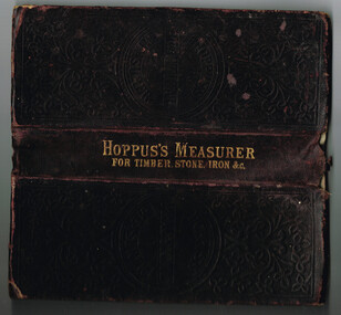 Otway Districts Historical Society
Book, Hoppus's Practical Measurer
Manufactured by E. Hoppus the Hoppus's Practical Measurer, or measuring made easy by a new set of tables which show by looking the solid content of any piece of timber, stone, etc, either square, round or unequally sided, and the value at any price of cubic feet. The book also gives the superficial comtent of boards, glass, painting and plastering with explanations of the uses and applications of the tables. The contents are given in feet, inches, quarters and twelfth parts of an inch. It includes the measurment of timber by several dimensions together with tables showing the weight of iron by measure.Hoppus's Practical Measurer; or, Measuring made easy by a new set of tables, which show, at sight, the solid content of any piece of timber, stone, &c. W. Nicholson & Sons; London; nd. 238 p. Hard cover.e. hoppus; measurment; timber; stone; boards; glass; painting; plastering, iron; -
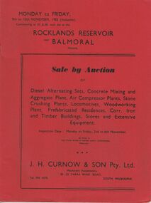 Bendigo Historical Society Inc.
Document - IAN DYETT COLLECTION: AUCTION CATALOGUE - ROCKLANDS RESERVOIR
Red covered catalogue for a Sale by Auction at Rocklands Reservoir near Balmoral, Vic. On the 9th to 13th November, 1953 (inclusive). For sale are Diesel Alternating Sets, Concrete Mixing and Aggregate Plant, Air Compressor Plants, Stone Crushing Plants, Locomotives, Woodworking Plant, Prefabricated Residences, Corr. Iron and Timber Buildings Stores and Extensive Equipment by order of The State Rivers & Water Supply Commission, Melbourne. Pasted in the front of catalogue is a slip to write name, address and phone number on and to give to clerk when making their first purchase. A typed note loose in the front of catalogue mentions that the time for removal of houses and buildings has been increased from four weeks to three months and goods would be at purchaser's own risk after time of sale. Descriptions of some of the items for sale. Catalogue has Ground Plans of the eight different residential houses. J. H. Curnow & Son Pty. Ltd. Were the auctioneers.business, auctioneers, j h curnow & son pty ltd, ian dyett collection - auction catalogue - rocklands reservoir, the state rivers & water supply commission, j h curnow & son pty ltd, balmoral combined women's associations, prahran telegraph printing co -
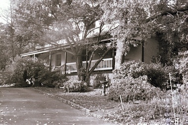
 Kew Historical Society Inc
Photograph - 'Glencara', 59 Sackville Street, 1988
The first documentary evidence of this house comes from Rate Books which record that in 1893 a Mrs Treadway was the owner of this building with an N.A.V. of £80. At that date the occupier of the house was Charles B. Kelly, a clerk, while by 1910 Kelly had become the owner of the property described in that year as a six-roomed stone, brick and wood house with stables and outbuildings.(Kew Conservation Study, 1988)Colour photographic positive of one of 'Glencara'. It is a single storeyed house clad in render and dominated by a verandah that wraps around the front and sides, following the line of the projecting polygonal bay window. The verandah has elegance, being supported on coupled candy-twist columns and decorated with cast iron, and it returns around to the side entrance. The slate roof is intact. (Kew Conservation Study, 1988)glencara -- sackville street -- kew (vic.) -
 Kew Historical Society Inc
Photograph - 'Glencara', 59 Sackville Street, 1988
The first documentary evidence of this house comes from Rate Books which record that in 1893 a Mrs Treadway was the owner of this building with an N.A.V. of £80. At that date the occupier of the house was Charles B. Kelly, a clerk, while by 1910 Kelly had become the owner of the property described in that year as a six-roomed stone, brick and wood house with stables and outbuildings.(Kew Conservation Study, 1988)Colour photographic positive of one of 'Glencara'. It is a single storeyed house clad in render and dominated by a verandah that wraps around the front and sides, following the line of the projecting polygonal bay window. The verandah has elegance, being supported on coupled candy-twist columns and decorated with cast iron, and it returns around to the side entrance. The slate roof is intact. (Kew Conservation Study, 1988)glencara -- sackville street -- kew (vic.)