Showing 680 items matching "land titles"
-
 Phillip Island and District Historical Society Inc.
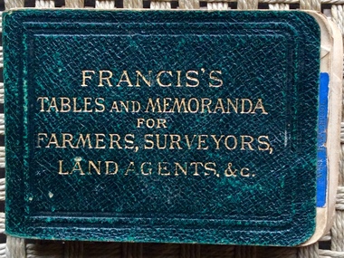
book, Francis’s Tables and Memoranda for Farmers, Surveyors, Land Agents & etc, 1900
Tiny dark green leather book with gold embossed title of measurements and farming advice. 256 pages plus advertisements.Francis’s Tables and Memoranda for Farmers, Surveyors, Land Agents & etc. Signed inside front cover by J. Armstrong and J. Oswinbook, farming, j. oswin -
 Ringwood and District Historical Society
Contracts, Acquisition of the land in Grey Street and Ware Crescent, Ringwood East by the Graduates Assoc. of the Kindergarten Training College, Melbourne. 1950-1960, 1950-1960
Various papers from the titles Office, City of Ringwood Solicitors for accounts on the purchase of the land by the Graduates of the Kindergarten Training College and caveats pertaining to the land. This was the site of the Warrawong day and residential care kindergarten which was demolished c.2000 to be divided into housing blocks.18 pages of documents relating to the acquisition of the land in Grey Street and Ware Crescent, Ringwood East by the Graduates Assoc. of the Kindergarten Training College, Melbourne. -
 Ringwood and District Historical Society
Article - Newspaper Clipping, Land Sale Advertisements, Golden Hill Estate, Ringwood - 1965, 1966, and Plan of Survey of Lot 8, Mullum Mullum Road Ringwood, 1970
... . Plan of Survey signed on 25.7.1970 by Roger M. Gamble, Land ...Newspaper clippings from Melbourne Sun newspaper (11th December 1965 and 15th January 1966) advertising sale of land - Golden Hill Estate, Ringwood, with summary of features and aerial photograph including artistic representation of street layout. Subdivision includes Mullum Mullum Road, Sonia Street, Jill Court, Linda Drive, Eve Court, Alma Court, and Jacynthe Court. Attachments include reference to Lot 46 as site of original Peter Vergers' orchard residence and subsequent 1970 surveyor's Plan of Survey of Lot 8 Mullum Mullum Road Ringwood, LP 67513, Cert of Title 8581/429.Agent - Aaron, King & Co., Suite 2, 33 Queens Road, Melbourne. (Phone) 26-2443, A.H. 850-2195. Plan of Survey signed on 25.7.1970 by Roger M. Gamble, Land Surveyor, 28 Summit Crescent, Ringwood 3134. -
 Ringwood and District Historical Society
Document, Land Title Certificate for Henrietta Greenwood of Ringwood, Vic. - 31st January, 1931. (4 pages)
... Land Title Certificate for Henrietta Greenwood of Ringwood..., 28 June, 1949 Certificate of Title - Henrietta Greenwood ...Certificate of Title - Henrietta Greenwood, Ringwood, Victoria, including Transfers and map of subdivisionIncludes transfers as part to Ernest Allan Devenish, 27th October, 1938 Lillian Alice Clegg, 10th July, 1936 Francis Leslie Little and Rose Little, 12 November, 1940 Ralph Wigley, 25 November, 1937 Alan Geoffrey Clegg, 25 November, 1937 Phillip McKinley, 8 May, 1941 John Andrew Pearson, 11 May, 1938 Paul Clegg, 8 May, 1941 The Mayor, Councillors and Burgsses of the Borough of Ringwood, 18 June, 1941 Ruby Grace Holloway, 15 October, 1941 William Herbert Holloway, 28 June, 1949 -
 Bendigo Military Museum
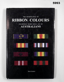
Book - BOOK, REFERENCE, Rick GREBERT/The Australian Army History Unit, "THE SIGNIFICANCE OF RIBBON COLOURS ON MEDALS WORN SINCE 1815 BY AUSTRALIAN", 2007
Peter Ball collection, refer Cat No 4704.Hardcover book with dust cover. Cover - cardboard with adhered paper cover. White print. Dust cover - paper with white print. On front and spine with black background. Illustrated in colour - front selection of 8 ribbons worn by Australians. Back - portrait of a soldier in uniform (Field Marshal Sir Thomas Blamey) 136 pages, cut, plain, white paper. Illustrated colour photographs of ribbons and medals. Handwritten - signature of author and owner's name.Handwritten - front end paper, owner's name "Peter C Ball". Title Page, signature of author "Rick Grebert".books, reference guide, history, military warfare -
 Bendigo Military Museum
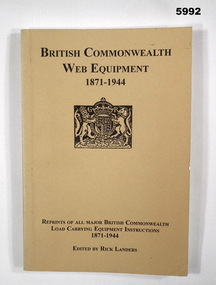
Book - BOOK, REFERENCE, Rick LANDERS, " BRITISH COMMONWEALTH WEB EQUIPMENT 1871-1944", 2005
... Ball". Title page - author - "Rick Landers".... signatures - front end paper - owner "Peter C Ball". Title page ...Peter Ball collection, refer Cat No 4704.Soft cover book. Cover - cardboard, black print on front and spine, beige background, small illustration. British Coat of Arms. 192 pages, cut, plain, white paper. Illustrated black and white illustration, diagrams and photographs. Handwritten - signature of author and owner's name.Handwritten signatures - front end paper - owner "Peter C Ball". Title page - author - "Rick Landers".books, reference guide, history, military accoutrements, british -
 Warrnambool and District Historical Society Inc.
Document, Accounts, Early and Middle 20th Century
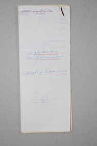
These pages of accounts are from the firm of Mackay Taylor, Lawyers, a prominent firm in Warrnambool for over 100 years. The Warrnambool legal businesses of George Mackay and James Fletcher merged in 1893 and was known as Fletcher and Mackay. In the 1920s Mr Mackay took J. McD Taylor as a partner and the premises at 131 Kepler Street were built about that time, with the firm being known as Mackay and Taylor. After the original partners died there was a succession of partners with the legal firm continuing as Mackay Taylor until the 1990s. These account sheets from a prominent 20th century legal firm in Warrnambool are of considerable importance as they document the legal records of many Warrnambool and district personalities from the early 20th century. The information contained in the sheets will therefore add to the known history of many local people from the past and will be very useful to researchers.These are handwritten accounts for bills to be paid to Mackay Taylor Lawyers for services rendered. The accounts are described in detail and are written on quarto size paper with the requisite red lines already printed on the pages. There are over 100 sheets and they date from 1938 to 1940. There are also two original Certificates of Title for Eva Willis (1916, portion of land in Cramer Street) and Archie Jackson (1924, portion of land in Cramer Street). warrnambool, warrnambool lawyers -
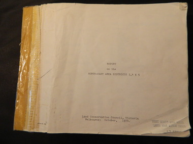 Kiewa Valley Historical Society
Report - Land Conservation Council x2, Land Conservation Council, Victoria Melbourne, April 1978, October 1974
... are 9 maps with color each with a different title. Land ...Land Conservation Act 1970 established the Land Conservation Council to investigate and recommend to the Minister use of public land in Victoria. It describes and assesses the natural resources:-Physiography, Geology, Topography, Land Systems, Outdoor Recreation, Public land and blocks. Primary Production. Vegetation.North East Victoria includes the Kiewa Valley. This report gives an understanding of the development of the area.Thick heavy book with 312 pages with black and white photos. Back half has a folder with heavy cardboard attached to thick cardboard back cover. Inside folder are 9 maps with color each with a different title.Stamped on Front Cover: "Mount Beauty High School" Has a library borrowing slip at the back of the last page.land conservation council, environment, public land, kiewa valley, planning -
 Kiewa Valley Historical Society
Folder - Kiewa Methodist Church, 1917 to 1962
The copy of a letter written by Harry H. Simmonds of Huon notes that "the church existed in 1905. It was built by Hill and McCormack with timber donated by Mr Ned Dunstan on ground donated by Mr James Thomas probably in the late 1800s. It was possibly called a Methodist Church because the donor of the land was a Methodist. It was used by the three Protestant Groups and maintenance was paid for by an annual area collection.The house on the west side was a Presbyterian Manse for many years and the block of ground on the north side was known as the Manse paddock in which the minister grazed his cow and horse." In 1936 there was a fence between the Kiewa Methodist Church was the Presbyterian Church in Kiewa. Its Certificate of Title is Volume 5134 Folio 1026783 (Sept. 1942.) In 1952, the church was made of wood with an iron roof. In 1954. Request to Yackandandah Shire re a fence from Kiewa Consolidated School entrance to the unused hedge adjacent to the Church. In 1958 there was correspondence re 'the strip of land on each side of the Church.' Churches were an important part of life during the late 19th century and early to mid 20th century and were built in the centre of town as was this one. These papers give an understanding of the work involved in maintaining a church. The letters and 'book' give a lot of names of local families involved with the Methodist Church at Kiewa. Yellow plastic spiral folder with 18 pages enclosed in clear plastic sleeves.Papers enclosed include accounts, payments, tenders and other correspondence relating to the Methodist Church at Kiewa dating from 1932 to 1962. Of particular interest is a black cardboard cover book dated 1917 re collection of donations from listed people. The latest date in the book is 1942.Enclosed in first plastic sleeve is a letter from the donor, Kathie Vines dated 15th July 2013methodist church; kiewa; harry h. simmonds; yackandandah council; -
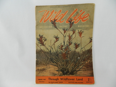 Kiewa Valley Historical Society
Magazine - Nature, Joseph Swanson Wilkinson, Wild Life Australian Nature Magazine, January 1949
This magazine was part of the Bogong School's library and represents an important aspect of the school's curriculum.Bogong School was noted for having a great interest in nature and conservation. 48 page soft covered magazine. Cover with limited colour including orange, black, white and brown with green. Inside pages in black, brown and grey pictures with black print on off white pages. Page 41 is in cartoon form. 'Registered at G.P.O. Melbourne for transmission by post as a periodical'. written in black in tiny print across the top. 1st line: 'Wild Life' in orange with white outline. 2nd line: 'Australian Nature Magazine' in white underneath title. All across top. 3rd written line: 'January, 1949 Through Wildflower Land 1/-' underneath picture of Kangaroo Paw. in black Underneath this writing follows: 4th line: 'Vol.11 No. 1 The Truth About Borers : : Beautiful Bird Pictures' in black Underneath 1/- is 'Monthly' Background behind black writing is orange same as title.bogong primary school. bogong. wild life. nature. -
 Warrnambool and District Historical Society Inc.
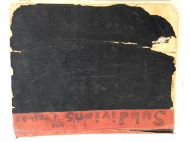
Book, Subdivision No 1 to 1420, 1930s
This is an exercise book listing subdivisions in Warrnambool from 1935 to 1977. There are 1420 entries. It gives details of the subdivisions – plan number, street, section number, allotment number, date, owner, solicitor and Titles Office number. The book is completely filled and today this information would be held in the Warrnambool City Council offices per electronic data storage. Warrnambool, founded in 1847, became a Municipality in 1856, a Borough in 1863, a Town in 1883 and a City in 1918. Subdivisions of land in the city continue to be made regularly for housing and business purposes.This book is of great historic interest because it details the subdivisions in the City of Warrnambool from 1935 to 1977. It shows the continuing growth of the city, particularly after World War Two. It will be a very useful resource for researchers. This is an exercise book with a black cardboard cover and red binding. It contains a list of City of Warrnambool subdivisions from 1935 to 1977. The cover and some of the pages are torn and ragged and the binding has come apart and has been glued together in places. The pages are ruled with blue and red lines. The pages contain handwritten material in black and blue ink. Front Cover: ‘Subdivions(sic), Nos 1 to 1420’ Inside Front Cover: ‘City of Warrnambool Subdivisions’ warrnambool city council, warrnambool subdivisions -
 Warrnambool and District Historical Society Inc.
Title Search Document, 1930s to 1960s
These documents concern the property in South Warrnambool, Jetty Allotment 7, Section 4. They include a search made of the title of this property in 1937 and information on later purchasers of the property. The first owner of this property was James Cust who purchased it in April 1853. James Cust (1815-1860) came from Ireland to Australia in 1841. From 1847 on he farmed first at Woodford and then moved into Warrnambool and began land speculating.. In 1856 his property was valued at £20,000 but by 1858 he was declared insolvent following the insolvency of his financial backer, William Bateman and his properties were sold. He died in 1860 following an accident at a Ballarat gold mine. Other notable Warrnambool identities who owned this property on Pertobe Road included Thomas King, Christopher Beattie, Thomas Goodall, William McMahon and Alan Lane.These documents are of interest as they detail the history of a property in Warrnambool up to the 1960s. They are also an example of the type of property once owned by James Cust, an important early land speculator in Warrnambool. These are nine loose sheets of paper concerning a legal search made of a block of land in Warrnambool and later documents on the same property The papers contain handwriting in blue and black ink and pencil and one red stamp. One of the pages is an invoice for the charge made for the search.‘Searched 25/5/37 W.D. Richardson Titles Searcher 418 Little Collins Street Melbourne C1’james cust,, history of warrnambool -
 Warrnambool and District Historical Society Inc.
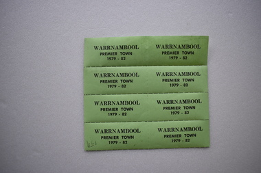
Label, Warrnambool Premier Town, 1979
These labels or stickers were produced as part of the celebrations and promotional material to be used during the period 1979 to 1982 when Warrnambool was the official Premier Town in Victoria. The title was awarded by the Premier of Victoria with scores allocated for heritage and environment, community participation, industrial and commercial development, tourism, land use and public works and community facilities. Warrnambool won the inaugural award in 1958, in 1979-82 and in 1988-91.These labels are of minor interest as reminders of one of the times when Warrnambool was awarded the title of Victoria’s Premier Town.These are eight green labels on a perforated sheet. They have black printing and an adhesive backing and are designed to be detached and used separately as stickers or labels.Warrnambool Premier Town 1979-82warrnambool premier town 1979-1982, history of warrnambool, label -
 Eltham District Historical Society Inc
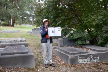
Photograph, Peter Pidgeon, Grave of Charlotte Amelia Taylor, Lillian Jane Taylor and Robert David Taylor, Eltham Cemetery, 5 April 2021
Robert David Taylor was a farmer who lived in Eltham all his life and died in 1934 at the age of 76. Mr and Mrs Bowman lived in York Street; Taylor was their neighbour. In 1933 he subdivided his land, the plan showing a proposed Grey Street flanked by residential blocks for sale. Mrs Bowman bought one: her family would be able to walk through it and along Grey Street to Henry Street, thus providing quicker access to the railway station. But Taylor retained ownership of Grey Street itself. He fenced it off at each end and charged the Bowmans with trespass when they used it. The matter went to Court. The ruling was that Mrs Bowman could use Grey Street, as she owned land in it, but her husband could not. (Taylor also accused the Bowmans of having broken the fences, but could not prove it.) Taylor had wanted to subdivide his land in 1914. Plans were submitted to Council and were approved, but the subdivision did not proceed. In 1919, Taylor doctored the plans to make it appear that a totally different subdivisional arrangement had been approved. The Titles Office immediately detected fraud, and the Crown charged Taylor with forgery and counterfeiting. But charges were later dropped (reason not recorded). He was an Eltham Shire Councillor between 1911 and 1920. In 1920, Council charged him with illegally felling 91 eucalyptus trees in Eltham Park (60% of them in a healthy condition), presumably to be sold as firewood. He was imprisoned pending trial. Taylor claimed that he had acquired from another man the right to remove timber and sued the Council for wrongful prosecution. The case eventually went to the State Full Court, with judgement given in favour of Council, on the grounds that any right acquired by Taylor covered only the removal of logs and refuse, not sound green timber. And his position as Councillor precluded him from acquiring the right anyway. Robert David Taylor was also a Trustee of the Wesleyan Church owned land at Lot 20 Henry Street, originally purchased in January 1855 for a chapel and from which David and Catherine Clark first ran their private school, the forerunner of the Eltham Primary School. The land was sold in November 1901 to the Hope of Eltham Tent No. 195 Victoria District Independent Order of Rechabites, for which his brother William John Taylor was a Trustee and became the home of the Eltham Rechabite Hall. In December 1921 it was again sold, this time to the community for use as the Eltham Public Hall, Robert David Taylor being a member of the Committee.Born Digitaleltham cemetery, gravestones, charlotte amelia taylor, eltham district historical society, heritage excursion, lillian jane taylor, richard pinn, robert david taylor -
 Eltham District Historical Society Inc
Document - Folder, Greensborough Railway Station Estate, Lots 26, 26A and 26B, Crown Portion 3, Parish of Nillumbik, County of Evelyn (Rattray Road, Montmorency)
Crown Portion 3 of Eltham, Parish of Nillumbik, County of Evelyn, Lots 26, 26A and 26B were part of the Greensborough Railway Station Estate. The land detailed is bounded by present-day Rattray Road, Reichelt Avenue, Wooded Way and Ryrie Court, Montmorency. Originally purchased in September 1913 by George William Miller, signwriter of Greensborough and Harry Frederick Miller, the land was sold to Mrs Margaret Barr Honeyman, 24 June 1918 on mortgage for £400, deposit paid £150. In February 1920, Mr Honeyman called for the title and paid off the loan early, settlement occuring 11 October 1920. Contents: 1. Handwritten payment plan (Sep 1913 to Mar 1923) for Lots 26, 26A and 26B being parts of Crown Portion 3, Parish of Nillumbik, County of Evelyn on the plan of subdivision making up the Greensborough Railway Station Estate situated on Rattray Road; purchased for £179.2.0 with a deposit of £18.0.0. 2. Receipt: From Messrs G.W. and H.F. Miller for £11.15.8 being instalment and interest, 9 Sep 1913 3. Invoice: To Messrs G.W. and H.F. Miller for £11.12.0 being instalment and interest due 15 Sep 1914 4. Contract of Sale: George William Miller and Harry Frederick Miller to Mrs. Margaret Barr Honeyman, in respect of sale of Lots 26, 26A and 26B for £400.0.0, 24 June 1918. Deposit of £150.0.0 balance to be paid half yearly instalments of £15 with interest at 5% per annum added. 5. Letter: Percy J. Russell, Solicitor to G.W. Miller, 5 Feb 1920 advising Mr Honeyman has called for the title and wishes to pay off mortgage. 6. Letter: Percy J. Russell, Solicitor to G.W. Miller, 11 Oct 1920 advising settlement and payment of Miller to Honeyman.contract of sale, george william miller, greensborough railway station estate, harry frederick miller, land sale, margaret barr honeyman, montmorency, rattray road, reichelt avenue, ryrie court, wooded way -
 Eltham District Historical Society Inc
Document - Certificate of Title, Landata, Vol. 4930 Fol. 985900, Crown Portion 15 Section 5, Parish of Nillumbik, County of Evelyn, 1925
... that the land allotment was subdivided into 48 lots. The title shows... that the land allotment was subdivided into 48 lots. The title shows ...(Cancelled) Certificate of Title originally issued for Crown Portion 15, Section 5 to Robert David Taylor, of Eltham, County of Evelyn, Farmer, 13 March 1925. It is with this title that the land allotment was subdivided into 48 lots. The title shows the issuance to Robert David Taylor with encumbrance placed upon it by immediate former owner, Hugh Patrick Keogh, a former member for Gippsland and Melbourne Real Estate Agent. Following Taylor's death in 1934 the title passes to his Executors, sons Robert David Taylor of Bible Street, Eltham and William McLelland Vance Taylor of Northcote. The property is then sold to Frank Stokes who develops the Stokes Orchard. Compulsory acquisitions by the Melbourne Metropolitan Board of Works and State Electricity Commission show provisions of easemenst for town water supply and high voltage power transmission lines. Subsequent lots are then sold off with the development of the Stokes Orchard Estate residential development in the mid to late 1970s. A History of the Development of Crown Allotment 15, Section 5, Parish of Nillumbik – Stokes Orchard Crown Allotment 15, Section 5, Parish of Nillumbik (CA15) is a square allotment of 158 acres or approximately a quarter of a square mile. It lies just beyond the eastern end of Pitt Street, south of Nyora Road to the northern end of Eucalyptus Road and extends east from Eucalyptus Road to Reynolds Road. The topography of CA15 is generally steep, sloping up to a hill near the centre of the land, the ridgeline passing through the properties along the southern side of Diosma Road. Eucalyptus Road is a straight north-south road with its northern end at the north west corner of CA15. Until the end of the 1970s this road was an un-named Government Road and was largely not open to traffic. With residential development in the 1970s the road was constructed, and the council allocated the name obviously in recognition of the predominant species of the local bushland. CA15 was purchased from the Crown by George D’Arley Boursiquot, a prominent Melbourne printer, on 28th October 1852. On November 23, 1922, former Member for Gippsland and Melbourne Real Estate Agent, Hubert Patrick Keogh purchased the allotment then sold it March 13, 1925, to local farmer, Robert David Taylor, a former Shire of Eltham Councillor (1911-1920) and Shire President (1919). Taylor had extensive land holdings stretching west towards Bible Street and Main Road. The Taylor home was situated at the top of the hill in Bible Street at present day 82 Bible Street. At the time of Taylor’s purchase in 1925, CA15 was subdivided into 48 lots that could be described as small rural properties or large residential lots. A typical lot size was one hectare or 2.5 acres. The subdivision created two roads, Nyora Road, and Diosma Road, each following an irregular alignment between Eucalyptus and Reynolds Roads. However, the lots were not sold off separately nor were the roads constructed. The land effectively remained as one parcel for many further years. Robert David Taylor died November 30, 1934, and probate was granted to his son of the same name, Robert David Taylor of Bible Street, Salesman and William McLelland Vance Taylor of 73 Emmeline Street, Northcote, Clerk, with the transfer of the land into their names on July 8, 1935. Frank Stokes worked as a qualified accountant at Kennons leather factory in Burnley, while living at 1 Thomas Street, Mitcham. He suffered from migraines and wanted to return to working the land (he had previously worked on farms and orchards since coming to Australia from England in 1926, both in WA and Vic.). He first travelled to the district by train in July 1942 to find land with the intention to establish an orchard. By chance he met Arthur Bird of Bird Orchard (bounded by Pitt Street, Eucalyptus Road, and Wattle Grove) and they got talking over their common interest. Arthur put Frank up for the night and pointed out the land, 158 acres- part of the Taylor Estate- £900, Crown Allotment 15, Section 5, Parish of Nillumbik (CA15) somewhat diagonally opposite Bird Orchard. Stokes applied through the Riverina Agency to purchase the land who in turn applied for permission from Canberra to sell as there was a new government regulation introduced during the Second World War banning land sales except for immediate production. Stokes obtained a loan on his Mitcham house of £600 @ 5% and paid £450 deposit with quarterly payments of £15 spread over 5 years. Stokes was assisted and advised by Arthur Bird who farmed the neighbouring orchard. In early 1943 Stokes took possession and would catch the train out to Eltham on Fridays after work and began building a hut on the corner of Nyora Road and the Government Road (Eucalyptus Road) for shelter and to lock up tools. He established an orchard on the central western part of the land through the centre of which ran a natural waterway (part of the present-day linear park) and was able to pay a neighbour (Hawkins) to help with clearing and fencing 25 acres, and with a horse and single furrowed plough, planted approximately 2,500 fruit trees - cherries, peaches, plums, almonds, pears, apricots and lemons as well as a few apples and oranges; a massive task. Aerial photographs from the 1940s through to the 1990s clearly show the orchard with most of the larger CA15 site remaining as natural bushland. A huge problem was hares and rabbits eating all the new buds off the tiny trees. As well as laying poison he painted the trees with a mixture of cow manure and lime, often working by moonlight. Procurement of wire and wire netting was difficult because of the war but after much effort he obtained a permit from the Agricultural Department for supplies in March 1944. In February 1945 Stokes applied for a permit to build a “packing shed” as no house building was allowed. It was to be 33 feet x 21 feet and cost £312. It was constructed mostly from second-hand materials, which were hard to obtain, especially iron for roofing. Stokes finished work at Kennons on October 31, 1945, and in March 1946 he sold the family home at Mitcham for £1,230 plus £170 for furniture. On May 15, 1946, title to the CA15 property was issued to Frank Howard Alfred Stokes, Orchardist and Gladys Ethel Stokes, Married Woman, both of Pitt Street, Eltham. The family of five then moved into the very unfinished “packing shed” at Eltham, which was a struggle to weatherproof. Eventually rooms were divided off and lined with hessian bags and whitewashed. Their income was firewood (cut and sold), selling rockery stones and cut Sweet Bursaria. (It was discovered during the 1940s that Sweet Bursaria contained the sunscreen compound Aesculin. The RAAF utilised this compound from Sweet Bursaria during WW2 for pilots and gunners.) The orchard’s first fruit sale was a half-case of Le Vanq peaches in December 1947 for the price of 8 shillings. In 1956 plans for house were drawn and Glen Iris bricks purchased (1956 Olympic Rings variant). The building of the house commenced in 1957 - 12 feet of original packing shed was removed – and was completed in 1959. Water was connected from newly built pressure storage on the property at the end of 1959 and the electricity connection for the first time at 3pm on April 29, 1960. The house remains to present day (somewhat modified) at 1 Nyora Road, home to Nyora Studio Gallery. On occasions, spare remnants of the 1956 bricks have been known to be unearthed in gardens on the estate as they were utilised by Frank Stokes to fill in rabbit holes. On May 26, 1950, a parcel of land was compulsorily acquired by the Melbourne and Metropolitan Board of Works on the hilltop to establish an easement for a high-level service reservoir to augment Eltham’s water supply. The project also included pipe tracks for the necessary water mains. The reservoir has now been superseded by higher level water tanks east of Reynolds Road and its former site is now a public reserve. On November 27, 1964, the State Electricity Commission served notice to compulsorily acquire a further parcel through the eastern part of the land for a major electricity transmission line that augmented supply from the La Trobe Valley to Melbourne. The easement was registered February 11, 1966. The easement was widened July 18, 1969 for a second transmission line to be constructed. In 1971 Melbourne Metropolitan Planning Scheme amendments adopted Nyora Road as the boundary between a residential zone to the north and a rural zone to the south. This determined the future development of the land. In the mid-1970s the Shire of Eltham divided the orchard into numerous rate-able parcel lots, the 48 lots having been established in 1925 and the subsequent rates assessment proved unsustainable for Stokes. He commenced selling lots outside the boundary of the orchard, north of Diosma and South of Nyora. However shortly later the land between Nyora and Diosma Roads and west of the electricity easement was sold and subdivided into residential lots, a housing development by Macquarie Builders and marketed as the Stokes Orchard Estate. New streets were created, and most were named after trees, although one, Stokes Place, commemorates the former owners. The development was undertaken in two stages; Stage 1 (1975) encompassing Scarlet Ash Court, Ironbark Close and Peppermint Grove bounded by Nyora and Eucalyptus roads and Stage 2 (1978) encompassing Stokes Place, Orchard Way, The Crest and The Lookout bound by Nyora and Diosma roads. The developer, Macquarie Builders went bankrupt shortly after the release of Stage 2 leaving many purchasers to fend for themselves and arrange for their own independent builders. There were also difficulties with sewerage for the land immediately south of Diosma Road and so the conventional residential lots were abandoned in favour of larger lots. The development of Orchard Way, The Crest and The Lookout did not proceed as planned and the proposed lots were incorporated into five-acre parcels instead. These included a low-density group housing development by the Graves family and the award winning Choong House (1983) with Gordon Ford developed garden immediately next door situated on the ridge of the hill nestled amongst the original bush, Eucalypt trees and Sweet Bursaria. In 1994, Nillumbik Shire Council applied Significant Environment and Significant Landscape overlays upon the properties on the south side of Diosma Road to ensure protection of this natural bush garden environment. With the arrival of the sewer along Diosma Road in the 1990s, most of these five-acre parcels have since been subdivided multiple times. The Choong house presently sits on a 2.7-acre property, which in 2022 Nillumbik Council nominated for Cultural Significance Heritage protection and is considered potentially significant at State level. The Stokes family were also associated with the Eltham Christian Church. In the 1970s this church had met in temporary premises in Eltham. Lots of the original 1925 subdivision remained south of Nyora Road and a number of these lots were utilized for the Eltham Christian School, which was established by the Eltham Christian Church in 1981. The school operated on this site until 2000. The premises are now used by The Vine Baptist Church. By the mid-1980s the whole of CA15 had been developed for residential and school purposes, except for the sections north of Diosma Road and between the transmission lines and Reynolds Road. Sewerage issues had been resolved for the section north of Diosma Road and in 1987 it was in the process of being subdivided into residential lots. The development coincided with the discovery of colonies of the rare and endangered Eltham Copper Butterfly on the site. This resulted in a community and political campaign to save the butterfly habitat. With the co-operation of the land developer the subdivision was altered to create two bushland reserves in the critical butterfly habitat areas. In the late 1980s the State Government was investigating options for establishing a metropolitan ring road link between Diamond Creek and Ringwood. The chosen route was adjacent to Reynolds Road and so this created a freeze on development of CA15 between Reynolds Road and the electricity easement. The ring road proposal was eventually abandoned, and this part of the land was subdivided into low density residential lots. Diosma Road has been discontinued at the electricity easement and the eastern part incorporated into View Mount Court with access from Reynolds Road. The whole of CA15 has now been developed for residential or associated purposes, ranging from conventional density to quite low density south of Nyora Road. Some remnants of the orchard remain, a few cherry trees on the Graves property and a lone apple tree in Stokes Place. The butterfly reserves comprise significant areas of remnant bushland. Linear reserves through the estate link with central Eltham via the Woodridge linear reserve and with Research along the electricity easement. CA15 as it exists today has a complicated history of rural use, Government acquisition, urban development, and community action. References: • “Stokes Orchard, an incomplete history”; Russell Yeoman with Doug Orford • Correspondence, Beryl Bradbury (nee Stokes) • Aerial Photographs, 1931-1991, Landata (landata.vic.gov.au) • Certificate of Title, Vol. 4930 Fol. 985900 • Plan Number LP 10859 neil webster collection, diosma road, eltham copper butterfly, eucalyptus road, ironbark close, nyora road, peppermint grove, power transmission lines, reynolds road, scarlet ash court, stokes orchard estate, stokes place, woodridge estate, frank stokes, certificate of title -
Glen Eira Historical Society
Letter - Kooyong Road, 415, Elsternwick
Two items about valuation of this property: 1/Typed letter dated 28/01/1977 from the Perpetual Executors and Trustees Association fo Australia Limited by Trust Officer RM Morrison to WV Scott of SP Simmond’s estate agents regarding the report and evaluation for the Sir Hugh Gerner Brian estate located at 415 Kooyong Road Elsternwick, included certificate of title. 2/Copy of typed letter by valuator WV Scott with details of the external and internal condition and valuation of the property with handwritten note,s dated 08/02/1977.kooyong road, elsternwick, brain hugh gerner sir, brain lady, land values, brick houses, bluestone -
Glen Eira Historical Society
Letter - Kooyong Road, 415, Elsternwick
Typed letter dated 28/01/1977 from The Perpetual Executors and Trustees Association of Australia limited by trust officer R.M. Morrison to W.V. Scott of S.P. Simmonds Estate Agents regarding the report and valuation of the Sir Hugh Gerner Brain estate located at 415 Kooyong Road, Elsternwick. Includes certificate of title and typed letter by valuator W.V. Scott with details of the external and internal condition and valuation of the property with handwritten notes. Dated 08/02/1977.kooyong road, elsternwick, brain hugh gerner, brick houses, brain lady, land values, sir blue stone -
 Eltham District Historical Society Inc
Film - Video (DVD), Frank Stokes, Stokes Family, 1950-1977
Various family scenes taken from outside the family home on the southeast corner of the intersection of Nyora Road and Pitt Street with Eucalyptus Road. Also, scenes of the Stokes Orchard and equipment used, construction of water reservoir at the end of Nyora Road near Reynolds Road and Diosma Road as well as early stages of the Stokes Orchard housing development. Frank Stokes worked as a qualified accountant at Kennons leather factory in Burnley, while living at 1 Thomas Street, Mitcham. He suffered from migraines and wanted to go back to the land (he had previously worked on farms and orchards since coming to Australia in 1926 both in WA and Vic.). He first travelled to the district by train in July 1942 to find land with the intention to establish an orchard. By chance he met Arthur Bird of Bird Orchard (bounded by Pitt Street, Eucalyptus Road and Wattle Grove) and they got talking over their common interest. Arthur put Frank up for the night and pointed out the land, 158 acres- Taylor Estate- £900, part of Crown Allotment 15, Section 5, Parish of Nillumbik (CA15) somewhat diagonally opposite Bird Orchard. He applied through the Riverina Agency to purchase the land who in turn had to get permission from Canberra to sell as there was a new government regulation banning land sales except for immediate production. He obtained a loan on his Mitcham house of £600 @ 5% and paid £450 deposit with quarterly payments of £15 over 5 years. The title to the property was issued May 15, 1946. He was helped and advised by Arthur Bird who farmed the neighbouring orchard. Early 1943 he took possession and would catch the train out to Eltham on Fridays after work and began building a hut for shelter and to lock up tools. He was able to pay a neighbour (Hawkins) to help with clearing and fencing 25 acres and with a horse and single furrowed plow, planted approximately 2,500 fruit trees - cherries, peaches, plums, almonds, pears, apricots and lemons as well as a few apples and oranges; a massive job. A huge problem was hares and rabbits eating all the new buds off the tiny trees. As well as laying poison he painted the trees with a mixture of cow manure and lime. Often working by moonlight. It was extremely difficult to get wire and wire netting because of the war but after much effort he obtained a permit from the Agricultural Department for supplies in March 1944. In February 1945 he applied for a permit to build a “packing shed” as no house building allowed. It was to be 33 feet x 21 feet and cost £312. Constructed mostly from second-hand materials, which was hard to obtain, especially iron for roofing. Frank finished work at Kennons October 31, 1945, and in March 1946 he sold the Mitcham house for £1230 plus £170 for furniture. The family of five then moved into a very unfinished at Eltham, which was a struggle to weatherproof. Eventually rooms were divided off and lined with hessian bags and whitewashed. Their income was firewood (cut and sold), selling rockery stones and cut sweet bursaria. (It was discovered during the 1940s that Bursaria contained the sunscreen compound Aesculin. The RAAF utilised this compound from Bursaria during WW2 for pilots and gunners.) The orchard’s first fruit sale was a 1/2 case of Le Vanq peaches in December 1947 - 8 shillings. In 1956 plans for house were drawn and Glen Iris bricks purchased (1956 Olympic Rings variant). The building of the house commenced in 1957 - 12 feet of original packing shed removed – and was completed in 1959. Water was connected from newly built pressure storage on the property at the end of 1959 and the electricity connection for the first time at 3pm on April 29, 1960. In the mid-1970s the Shire of Eltham divided the orchard up into numerous rate-able parcel lots, which became unaffordable for Frank. Consequently, Stokes Orchard was turned into a housing development by Macquarie Builders and marketed as the Stokes Orchard Estate in two stages; Stage 1 encompassing Scarlet Ash Court, Ironbark Close and Peppermint Grove bounded by Nyora and Eucalyptus roads c.1976 and Stage 2 encompassing Stokes Place, Orchard Way, The Crest and The Lookout bound by Nyora and Diosma roads c.1979. The development of Orchard Way, The Crest and The Lookout did not proceed as planned due to the lack of the sewer along Diosma Road and so many of the proposed lots were incorporated into five-acre parcels instead. With the arrival of the sewer along Diosma Road many years later, most of these five-acre parcels have since been subdivided many times.Representative of the orchard growing areas of ElthamMP4 00:24:39; 426MB Digital file only - Digitised by EDHS from a DVD copy on loan from Beryl Bradbury (nee Stokes), daughter of Frank Stokes. 24 min duration compilation of home movie Super 8mm film shot by Frank Stokes brother-in-law.beryl bradbury (nee stokes) collection, frank stokes, nyora road, stokes orchard, stokes orchard estate, stokes place, video recording -
 Eltham District Historical Society Inc
Slide - Photograph, Eltham Town Park, c.May 1988
In 1981 the Shire of Eltham Historical Society was asked by the Victorian Place Names Committee to comment on a proposal by the Shire of Eltham to assign names to parklands in Eltham as follows:- "Eltham Common" - the area between the municipal offices, Main Road, the Eltham railway -line, and Panther Place and containing Shillinglaw Cottage. The Shire has advised that this name has been used locally for the site since about 1975. "Alistair Knox Park" - the area bounded by the Eltham railway -line, Panther Place, Main Road, Bridge Street, and Susan Street, and through which flows the Diamond Creek. The area has been known locally as "Eltham Town Park" The proposed name "Alistair Knox Park" had created some local controversy with a number of reversals of the Council's decision and letters to the local paper both for and against the proposal. The society was reluctant to be drawn into this controversy particularly as there were known to be members with strong views both for and against the proposed name. The society appreciated the work done by Alistair Knox both in the formulation of the park concept and in its development but because of the controversy generated by the proposed naming and also because of the wide general use of the park by the public·, the name Eltham Town Park was felt more appropriate. The society noted that there was no outstanding historical associations with the land comprising the park which would warrant naming the park after any particular person, place or event. No objection was raised to the Eltham Common proposal as set-out above. The decision was made in the knowledge that Alistair Knox had been associated with the society over many years and was a prominent figure in the recent history of Eltham. He was regarded as a key figure in the environmental building movement and in particular was renowned for his use of mud bricks as a building material. He served as a councillor of the Shire of Eltham from 1971-1975, his final year as Shire President. It was during these years that the proposals to create the park in its present form were shaped and Alistair played a leading part in the decision to make it a landscaped passive recreational park rather than a sporting area. The parklands comprise a section of the Diamond Creek valley. The creek itself flows through the centre of the area which is overlooked by steep hills on each side. The parks form part of the land purchased from the Crown in 1851 by J.M. Holloway and then subdivided into allotments and called "Little Eltham". While most of the area was subdivided into residential lots the creek valley was subdivided into lots suitable for small farms. Some further subdivision took place over the years and the whole of the parks now comprises eight separate titles. A list of some of the former owners has been compiled but exhaustive research on all owners has not been carried out. The ownership of one parcel has been traced back to when it was purchased from Holloway by John Hicks Petty in 1874, long after it was subdivided. Other families owning land within the area over the years included Lyon, Rees, Clark, Waterfall, Carrucan, Graham, Hill and Morant. The character of the valley area has remained rural while development occurred on each side. Early photos show the area as orchard and grazing land. In 1901 the railway was constructed through the area resulting in the timber trestle bridge across the Diamond Creek. which is an important feature of the park landscape. A memorial obelisk to the Eltham servicemen killed in World War 1 was erected at the south eastern corner of the park. The site is now within the intersection of Main Road and Bridge Street and the memorial was shifted in the 1950s to the Eltham R.S.L. clubrooms. Following the financial failure of the local sub-branch, the memorial obelisk was again relocated to the Eltham War Memorial building precinct in 2011. During the early 1960's the Council started purchasing the land which now comprises the parks. In the late 1960's the area to the east of the Diamond Creek was used as a garbage tip and filled above the flood plain of the creek. When this area was filled the tip was transferred to the west side of the creek. From the early 1970's the area has been progressively developed as a park for passive recreation with ornamental lakes, extensive tree planting and landscaping. The character of the valley before the days of the tip has been recreated and this has earned a Landscape classification from the National Trust, an unusual honour for a man-made landscape. The parks are not only attractive in appearance. The large number of people using them, particularly at weekends and holidays is evidence of their popularity and the foresight and careful planning of local residents, Councillors and Council Staff. 35mm colour positive transparency (1 of 23) Mount - Kodak EktachromeProcess Date MAY 88Meltham, main road, alistair knox park, eltham town park -
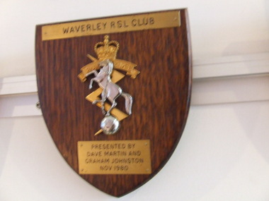 Waverley RSL Sub Branch
Plaque Royal Australian Electrical and Mechanical Engineers, Royal Australian Electrical and Mechanical Engineers
The Royal Corps of Australian Electrical and Mechanical Engineers (RAEME; pronounced Raymee) is a corps of the Australian Army that has responsibility for the maintenance and recovery of all land electrical and mechanical equipment. RAEME has members from both the Australian Regular Army and The Army Reserve. Prior to being given the title of 'Royal', the Australian Electrical and Mechanical Engineers (AEME) were raised on 1 December 1942. Some 64 years later, on 1 December 2006, the last independent RAEME Workshop was disbanded. RAEME soldiers continue in their role to provide support through attachment to other units in Tech Support Troops, Sections or Platoons.Wooden Plaque 15cm x 13cm with insignia of Royal Australian Electrical and Mechanical Engineers Royal Australian Electrical and Mechanical Engineers -
 Marysville & District Historical Society
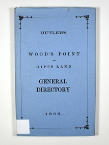
Book, Butler's Wood's Point and Gipps Land General Directory 1866, 1985
A directory of the local businesses, road guides and table of distances in the Wood's Point, Jamieson, Omeo and Bairnsdale areasHardback. Blue dust cover. Title in black on the front cover.Stamp of the Marysville & District / Historical Society Inc / P.O. Box 22 / Marysville 3779directory, wood's point, gippsland, victoria, history, jamieson, bairnsdale, omeo, road guide, table of distances, advertisements -
Lara RSL Sub Branch
Book, Australian War Photographs, 1919
The graphic pen-pictures of the war correspondents we have learned much of the conditions under which our soldiers lived and fought, but no matter how vivid the presentation, words alone cannot fully convey to the civilian an accurate impression of the battle area. Many of these photographs were taken under heavy fire showing the actual scenery amid which some of the most thrilling acts in the great drama of WWI were displayed. A pictorial record of places and events of our heroic soldiers who served in WWI. Each photograph of the sectors on which they fought will stimulate old memories - some sad, some pleasant, but all unspeakably dear. Australian War Photographs - Printed 1919. A pictorial record from November, 1917 to the end of WWI. Soft cardboard cover front back and spine. The back cover has the badge of the Australian Commonwealth Military Forces badge. The front cover has the title and silhouette illustration of WWI soldiers in the trenches and/or 'no man's land'.wwi, war correspondents, pen pictures, condition under which our soldiers served., official photographers -
 Lara RSL Sub Branch
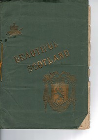
Large Book, BEAUTIFUL SCOTLAND
Signed & dated 1916.Prefaced"a few examples of some of the famous,the beautiful,and the historicplaces for which this delightful land is so justly renowned.....The craftmanship in producing such a record of that time.Historic & Artistic significance.Surely rare therefore highly significant.LARGE "Portrait"slender book of views of SCOTLAND .Cover green cardboard pages aged cream .Gold embossing to front cover .Front Cover....Gold embossed title Beautiful Scotland ...COAT of ARMS DEPICTING LION RAMPENT ,ACROWN ,,ATARTAN&SCOTCH THISTLES.ALSO A CROWN ON ACUSHIONWITH A SCEPTRE . -
Lara RSL Sub Branch
Book, Australian War Photographs, 1919
The graphic pen-pictures of the war correspondents we have learned much of the conditions under which our soldiers lived and fought, but no matter how vivid the presentation, words alone cannot fully convey to the civilian an accurate impression of the battle area. Many of these photographs were taken under heavy fire showing the actual scenery amid which some of the most thrilling acts in the great drama of WWI were displayed. A pictorial record of places and events of our heroic soldiers who served in WWI. Each photograph of the sectors on which they fought will stimulate old memories - some sad, some pleasant, but all unspeakably dear. Australian War Photographs - Printed 1919. A pictorial record from November, 1917 to the end of WWI. Soft cardboard cover front back and spine. The back cover has the badge of the Australian Commonwealth Military Forces badge. The front cover has the title and silhouette illustration of WWI soldiers in the trenches and/or 'no man's land'.wwi, war correspondents, pen pictures, condition under which our soldiers served., official photographers -
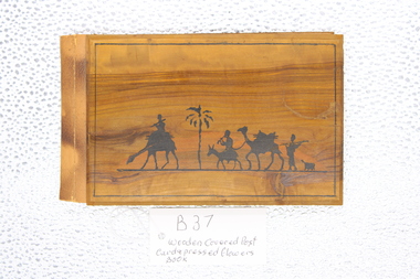 Shepparton RSL Sub Branch
Postcard and Pressed Flowers Book, Wooden Covered Postcard and Pressed Flower Book from Jerusalem 1941, approximately 1941
souvenirs from the middle Eastern Countries during WW2A wooden covered book; 10 pages with post card and on left hand side and pressed flower arrangements on opposite page. Pages separated by translucent tissue paperBlack inked drawing depicting camels , cameleers and palm tree on front cover; central back wooden cover 'Jerusalem' printed Inside cover in handwriting " To Mother From Dad 18th January 1941" Book title " Flowers and Views of the Holy Land - Fleurs et vues de la Terre Sainte" postcard pressed flower book -
 Federation University Historical Collection
Document, Declaration of Ernest by owners of land in Yendon being held as a site for Public Hall and Free Library; 1891, 1891
... land title... of Yendon. Land that had been purchased - being part of Crown ...Document outlining the agreement between five males, all residents of Yendon. Land that had been purchased - being part of Crown Allotment Five Section six, Township of Buninyong East, Parish of Buninyong, County of Grant, has been purchased "as a site for a public hall and free library for the use and benefit of the inhabitants of the Township of Yendon."Thick paper, hand written. Red dots indicate places for signatures Document stamped in green - 0122083 Signatures of; John Winterburn Kemp, Philip Ballantyne, Samuel Henry Mayo, Thomas Dooley, Thomas Watsondeclaration of ernest, land title, free library, public hall, yendon, buninyong, paris of buninyong, county of grant, john winterburn kemp, philip ballantyne, samuel henry mayo, thomas dooley, thomas watson -
 Bendigo Military Museum
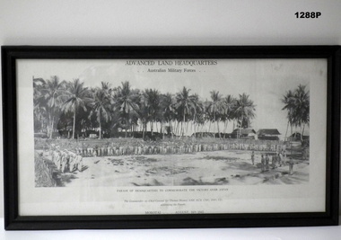
Photograph - PHOTOGRAPH, FRAMED, AUGUST 16 TH 1945
... Black print on Photograph title ‘ADVANCED LAND HEADQUARTERS... - photographs-frame accessories WW2 Black print on Photograph title ...PHOTOGRAPH OF A PARADE AUGUST 16TH 1945Photograph- copy of black and white photograph of “PARADE OG HEADQUARTERS TO COMMEMORATE THE VICTORY OVER JAPAN “. Photograph depicts troops on parade with tall palm trees in the background. Black print above and below photograph Frame-black colour paint on timber frame with cardboard back and glass front. Handwritten on back - donation information Black print on Photograph title ‘ADVANCED LAND HEADQUARTERS/AUSTRALIAN MILITARY FORCES “ Below photograph “PARADE OF HEADQUARTERS TO COMMEMORATE THE VICTORY OVER JAPAN/ MOROTAI AUGUST 16 TH 1945photograpy - photographs-frame accessories, ww2 -
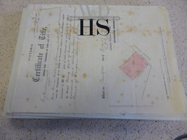
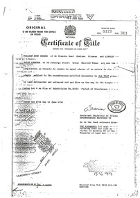 Marysville & District Historical Society
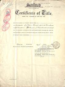
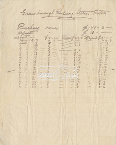
Document (Item) - Certificate of Title, Office of Titles, 19-06-1961
... A copy of the Certificate of Title for the land where Past...A copy of the Certificate of Title for the land where Past... of the Certificate of Title for the land where Past Favorites in Marysville ...A copy of the Certificate of Title for the land where Past Favorites in Marysville in Victoria was located.A copy of the Certificate of Title for the land where Past Favorites in Marysville in Victoria was located. Past Favorites was a bric a brac shop in Marysville in Victoria that was situated in Murchison Street. The building, along with most of the town, was destroyed in the 2009 Black Saturday bushfires.past favorites, marysville, victoria, murchison street, bric a brac, 2009 black saturday bushfires, william john cuzens, lindsay alice cameron -
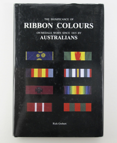 Mission to Seafarers Victoria
Book, Landers Publishing, The Significance of Ribbon Colours On Medals Worn Since 1815 by Australians, 2007
This book covers British Orders, Decorations and Medals awarded to Australians, the Australian Honours system, United Nations and NATO Medals awarded to Australians, Foreign Orders, Decorations and Medals awarded to Australians, Association and other Unofficial Medals worn by Australians, and the Order of Wearing Australian Honours and Awards.This 136-page hard cover book with identical dust cover, written by Rick Grebert. The cover is black with the title and author's name printed in white and features a selection of eight medals worn by Australians. Includes bibliographical references (p. 127-129) and index. Back cover features a coloured photograph of Field Marshal Sir Thomas Blameynon-fictionThis book covers British Orders, Decorations and Medals awarded to Australians, the Australian Honours system, United Nations and NATO Medals awarded to Australians, Foreign Orders, Decorations and Medals awarded to Australians, Association and other Unofficial Medals worn by Australians, and the Order of Wearing Australian Honours and Awards.medals, badges, decorations, australian army, armed forces, australia, rick grebert, ribbons