Showing 174 items matching "land transport"
-
 Melbourne Tram Museum
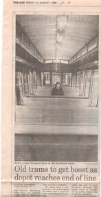
Newspaper, The Age, Progress Press, "Old trams to get boost as depot reaches end of line", 1998
Set of 11 newspaper cuttings about the planning for the Hawthorn Tram Museum Depot and the redevelopment of the site to apartments. .1 - The Age - 14/8/1998 - "Old trams to get boost as depot reaches end of line", featuring comments from the Minister for Transport Robin Cooper, quotes Michael Norbury. Has a photo of Senior Trainer Margaret Drew at the Southbank depot sitting inside tram V 214. Article by Lyall Johnson, photo by Luis Ascui. .2 - Progress Press - 17/8/1998 - "Site sale plan to fund new museum" - notes Urban Land Corporation .3 -The Age, 19/8/1998 - "Tram depot is saved by the bell" - about the proposed redevelopment - article by Paul Robinson, photo of the building by Sebastian Costanzo. .4 - Progress Press - 2/11/1998 - "Doubt over tram depot" - George Svigos .5 - Progress Press - 2/11/1998 - "Vintage tram a turn up", about the ownership of Ballarat 36 by the City of Hawthorn. Also notes the Box Hill extensions. .6 - Progress Press - 16/11/1998 - "Tram depot plan on track" - about the depot development and the TMSV. Includes a photo of Rod Atkins at the depot. Article by George Svigos, photo Tony Gough. .7 - Progress Press - 16/11/1998 - "Tram plan looks a goer" - Now the Boroondara Council. .8 - Progress Press - 14/12/1998 - "Old depot plans call" - article by George Svigos .9 - Progress Press - 30/11/1998 - "the gravy tram - featuring W1 431 outside the Hawthorn Tram depot and the free historic tram service Camberwell junction for Christmas. .10 - Progress Press - 23/11/1998 - "Heritage tram junction jaunt" - see above. .11 - Inside Melbourne - 14/12/1998 - advertising the heritage tram service with V214 and 164.trams, tramways, hawthorn tram depot, tram museum, museums, minister for transport, city of hawthorn, ballarat, camberwell junction, vintage trams, tram 36, tram v214, tram w1 431 -
 Melbourne Tram Museum
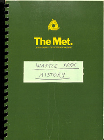
Document - Report, The Met, "Wattle Park", 1989
Report - approx. 90 A4 photocopied sheets, within a green cover preprinted for "The Met", titled "Wattle Park" containing many documents concerned with the history of Wattle Park and its status legally within a black comb binder. Comprises: 1 - Map 2 - two page letter from Tom Roper Minister for Planning and Environment to Jim Kennan Minister for Transport dated 22/11/1988. 3 - two page history 4 - two page extract from the Nov - Dec 1966 issue of MMTB News 5 - 23 pages - handwritten "Notes of Address on early history of Wattle Park given by A. J. Holt to the Box Hill Historical Society Nov. 1986. 6 - 10 page extract of the Act authorising the HTT to acquire the land and extracts from Hansard 7 - 4 page letter by the Office of the Solicitor to The Met Property department 1/12/1986 about the use of the land and charging fees for its use. 8 - 15 page legal advice re the use of the land and its permitted uses. 9 - 13 page follow up advice by P. N. Wikrama dated 20/6/1989 10 - 6 page photocopy of the certificates of title. Each section separated by a green sheet.trams, tramways, wattle park, legal agreements, htt, mmtb, the met, minister for transport -
 Melbourne Tram Museum
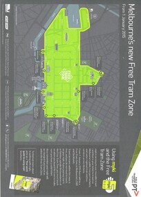
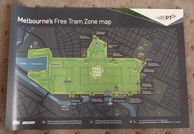
Map, Public Transport Victoria (PTV), "Melbourne's new Free Tram Zone", 2015
Printed A4 sheet - single sided off white sheet titled ""Melbourne's Free Tram Zone Map"., details the extent of the free tram zone or showing the tram lines that the free travel is allowed, locations, land marks, contact numbers and has the PTV logo in the top right hand corner and the Myki locos along with Yarra Trams and contact details for information. Dated 1/1/2015.trams, tramways, yarra trams, ptv, maps, free tram, melbourne -
 Melbourne Tram Museum
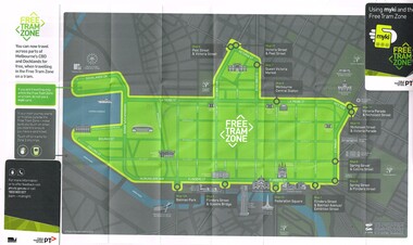
Map, Public Transport Victoria (PTV), "Using myki and the Free Tram Zone", 2015
Folded paper map with glued card in two of the corners to give the document some strength or usability (24 folds), titled "Using myki and the Free Tram Zone" details the extent of the free tram zone or showing the tram lines that the free travel is allowed, locations, land marks, contact numbers and has the PTV logo in the top right hand corner and the Myki logos. The reverse details how the Myki system works, the various types of tickets, how to buy, visitor packs and using and managing Myki tickets.trams, tramways, yarra trams, ptv, maps, free tram, melbourne, myki -
 Melbourne Tram Museum
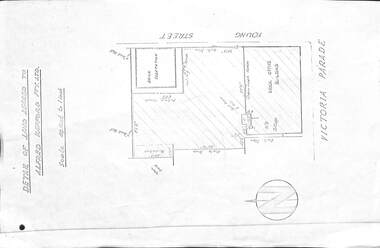
Drawing, Melbourne & Metropolitan Tramways Board (MMTB), "Detail of land leased to Alfred Kefford Pty Ltd", undated
Photocopy of a drawing or plan on an A4 sheet, titled "Detail of land leased to Alfred Kefford Pty Ltd" and the back of the former MMTB Office building in Victoria Parade Fitzroy. Gives the block dimension, streets, a location of a workshop and the brick office building. The Young St sub-station was excluded. Gives details of the fences. Plan undated. Rod Atkins advised 29/7/19 that Alfred Kefford nee Pty Ltd. resided at no 17 Young Street on corner of Duke Street just several doors further up Young Street on the same side. All I know so far is they were into some form of delivery type transport - i.e.. carrier.trams, tramways, mmtb, buses, lease agreement, victoria parade, young st, substation -
 Melbourne Tram Museum
Poster, Public Transport Victoria (PTV), "Melbourne's Free Tram Zone Map", Sep. 2014
Set to two full colour posters printed on a plasticized based sheet, titled ""Melbourne's Free Tram Zone Map". 626.1 - Poster showing the tram lines that the free travel is allowed, locations, land marks, contact numbers and has the PTV logo in the top right hand corner. 626.2 - Poster showing the logo or tram stop id that the free tram zone travel applies to. See Reg Items 1954, and 1956 for associated printed materials and 2790.2 for driver announcements.trams, tramways, yarra trams, ptv, maps, free tram, melbourne -
 Melbourne Tram Museum
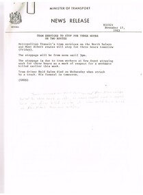
Document - Press Release, Minister of Transport, "Press Statement", Nov. 1987
Set of 11 New Releases or Press Releases with Minister of Transport letterhead. Photocopied onto A4 paper. 1. Tram services to stop for three hours on North Balwyn and Mont Albert - 18/11/1983 as a mark of respect to Naid Salem when struck by a truck at the Mont Albert terminus on 16/11. (hand written not on the sheet). 2."The Met" fare system starts today - Steve Crabb - 13/11/1983. 3. "New tram a design to meet the needs of the year 2000" - Minister visits Comeng Plant - A class trams 4. "Bonus travelcard on sale" - 10/11/1983 5. "A tram for the year 2000" - follow up - issued 11/11/1983 - A class trams. 6. "New Rail land sale on tomorrow - sale of surplus land in Doncaster - Templestowe Area" - following a decision to consider light rail rather than heavy rail. 7 "Homes now getter Transport Information Booklet" - explaining the Neighbourhood system. 8. "One Million booklets to be home delivered to explain The Met transport system" - 6/11/1983. 9. "Public Transport more cost efficient than the car" - 7/11/1983 - looks at The Met tickets pricing. 10. "Boards name for the New Transport Authorities" - 28/6/1983 - lists the names for the various authorities.Item 4 has a handwritten note in ink "NB now half a "Grand Union" at Sydney Road & Moreland Rd"trams, tramways, news broadcasts, minister for transport, mont albert, tickets, a class, doncaster, neighbourhood tickets -
 Melbourne Tram Museum
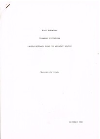
Document - Report, Melbourne & Metropolitan Tramways Board (MMTB)?, Ministry of Transport?, "East Burwood Tramway Extension - Middleborough Road to Vermont South - Feasibility Study, Oct. 1981
Report - 43 pages, photocopied, stapled in top left hand corner - titled "East Burwood Tramway Extension - Middleborough Road to Vermon South - Feasibility Study - October 1981". No details as who made the report, assumed Ministry of Transport or MMTB. Gives details of proposals considered, population and land use, existing services, patronage, operating costs, revenue and provides an assessment. Looks at costs for an extension only to Blackburn Road, Springvale Road and to Vermont South. Report showed the cost benefit ratio for Blackburn Road was 1, and less for the other possibilities.trams, tramways, east burwood, feasibility study, new tramway, mmtb, middleborough rd, vermont south -
 Melbourne Tram Museum
Magazine, Department of Infrastructure (DOI), "New Home for Heritage Trams", Dec. 1998
Eight page magazine, folded A3 printed on gloss paper, blue and black ink, "Infrazine" - Department of Infrastructure Victoria, Issue 11, December 1998 with the main article on the redevelopment of Hawthorn Tram depot - titled "New Home for Heritage Trams". Gives details of the history of the depot, involvement of the Department of Infrastructure, Public Transport Corporation, and the Urban Land Corporation, TMSV and the future use of the heritage trams. Article signed by Brandon Mack. Other items cover legal services, the Marine Board, regional offices.trams, tramways, hawthorn depot, ptc, doi, reconstruction -
 Melbourne Tram Museum
Document - Report, Minister of Transport, "Bringing history back to life - The Hawthorn Tram Depot", Aug. 1998
Report - consultation document titled - "Bringing history back to life - The Hawthorn Tram Depot", 7 A4 sheets, photocopied, outlining the joint Public Transport Corporation (PTC) and Urban Land Corporation (ULC) study into the future of the Hawthorn Tram Depot. Includes a site plan or location map, consultation proposals, news release from the Minister for Transport - Mr Robin Cooper - dated 12/8/1998 and background document providing details of some of the heritage trams - both the PTC and the TMSV. Two copies held - one stapled. Imaged as a pdf file.trams, tramways, hawthorn depot, heritage, minister for transport, tram depot -
 Wangaratta RSL Sub Branch
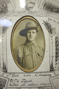
Mixed media - Framed Photograph and Medals, Private Percy Albert TIPPETT 483
Memorial plaque or death penny, medals and photograph of Private Percy Albert TIPPETT 483 who served with the 6th Battalion AIF and was wounded on the 25/4/15 during the initial landing at Gallipoli and died on 28/4/1915.Percy, aged 19, was one of the first young men from Wangaratta to enlist in the First AIF, Service No. 483. He was posted to the 6th Infantry Battalion on 19th October 1914 and sailed from Melbourne on HMAT Hororata. On 25th April 1915, Percy was in the initial landings at Gallipoli when he was seriously wounded. He was retrieved and taken to a transport ship for medical attention but unfortunately did not respond to treatment and died from his wounds on 28th April 1915. The Tippet family has a long and direct association with the land where the memory of Percy is commemorated and now known as 'Percy Tippet Reserve`.Timber frame with photograph of solider, four medals with ribbons and death pennyMedals include: The Victory Medal, The British War Medal, The Memorial Plaque and the 1914/15 Starpercy tippett, ww1, wangaratta, gallipoli, 6th battalion -
 Kew Historical Society Inc
Photograph - Country Roads Board and Denmark Street Baby Health Centre, Ron Setford, 1961
Ron Setford and his wife Grace Setford lived in Tanner Avenue, East Kew, from c.1946 to c.1995. A keen photographer, he recorded the changing face of Kew over a 20 year period. Apart from 30 photographs of built structures and places in Kew dating from 1960 and 1961, 145 of his 35mm colour slides chronicle the development of the Eastern Freeway through the Yarra Valley over a five year period from c.1972 to c.1977. This important collection was donated to the Society by his granddaughter in 2025.This collection of 175 35mm slides is of local and statewide significance, owing to its subject matter, particularly the major development of road transport infrastructure during the 1970s with the construction of the Eastern Freeway. The photographer also took care to annotate and date most of his slides which enable the researcher to pinpoint temporal and spatial locations.A photograph providing a visual contrast of the pre and post-World War II architectural styles of the Denmark Street Baby Health Centre and two of the Country Roads Board office buildings. Each was built on part of the land fronting the Kew branch line. In May 1939, the Railway Commissioners agreed to lease a site at the Kew Railway Station for a Baby Health Centre. The single-storey cream brick building was designed by Roland Chipperfield. The Country Roads Board (1913–83), later renamed VicRoads, transferred its headquarters from the Royal Exhibition Building to Kew in 1961, following the completion of two modernist eight-storey office towers in 1960. The VicRoads buildings were closed in 2024, and there is ongoing debate about what replaces them.Nilron setford, photographs -- kew (vic.) -- 1960s, country roads board, vicroads, denmark street -- kew (vic.), denmark street baby health centre -
 Lakes Entrance Historical Society
Book, McGrath, Michelle, Trestle Bridge, 2005
... Transport Bridges Conservation and Land Management Culture ...Research, interpretation and management recommendations for the trestle bridge at Stony Creek, Nowa Nowa, Gippsland, VictoriaConservation and Land Management Culture Analysis Reporttransport, bridges -
Lakes Entrance Historical Society
Book, Orbost Historical Society Inc, Barns of the Snowy River Orbost, 2006
Documents the distinctive slatted barns of the Lower Snowy River, Orbost, Victoria. Includes sketch maps, barn plans, history of area and families and personal ineterviews.Ngaire Donald May Leatchland settlement, agriculture, natural disasters, transport -
 Federation University Historical Collection
Photograph, James (Jim) Smith of Happy Valley
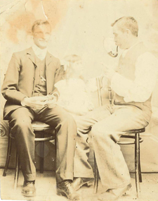
James (Jim) Smith, (died 03/08/1974, aged 93 years) established an orchard growing snow apples near in Happy Valley after returning from mining activities in South Africa. The orchard was called "Springdallah" and was beside the Linton/Happy Valley Road across from the old Happy Valley railway station. Jim was the son of George Henry Smith (18/12/1840 - 26/11/1903) and Emma Keys Smith born Keys (07/08/1842 - 28/08/1888). George and Emma left Liverpool with other unassisted immigrants on the "Bates Family" ship with baby Clara on 08/06/1863 arriving in Melbourne on 08/06/1863. George and Emma emigrated to Australia on the invitation of Emma's brother Edward Keys who owned a property near the school at Happy Valley on which there were two houses. Teddy offered George and Emma the smaller one to live in. When "Teddy" decided to go into hotel keeping George took over the 200 acres of his property and made it a pleasant orchard and garden called "Cress Green Gardens". George had various secretarial jobs - rate collector; paymaster at the mines; until he became Shire Secretary for the Shire of Grenville, whose centre was Linton and Government Auditor for Western Victoria (1894-1903), the means of transport being horse and buggy. Another son followed his father as Shire Secretary. George and Emma had 14 children, Emma dying giving birth to Emma Keys who lived for 16 months. George later married Annie Bolte with 2 more children being born. Annie later sold the property. The land was used for grazing and the two houses fell into disrepair. In 1995 George's grandson Ernest (Alf) Alfred Watson visited the site and reported a wrought iron gate at the site and a mulberry tree near the site of his grandmother's family home. Bluestone blocks can still be seen in the paddocks from the roadside. The child in the photograph is Phyllis Joy Smith, Jim's eldest daughter. Jim Smith was the brother of Clara Emma Yung nee Smith.Sepia photo of two men and a girl. One of them is Jim Smith who established on orchard at Happy Valley. He also went to South Africa - mining activities. The orchard is now part of Clarkesdale Bird Sanctuary located at 360 Linton-Piggoreet Rd, Linton, Vic. 3360. Verso: Jim Smith South Africa (Mining) Established orchard halfway near Linton and Happy Valley. Clara Emma's brother. jim smith, james smith, clara emma smith, happy valley, yendon, piggoreet, south africa, mining, orchard, edward keys, george henry smith, emma keys smith, clara emma yung, annie bolte, shire of grenville, clarkesdale bird sanctury -
 Sunbury Family History and Heritage Society Inc.
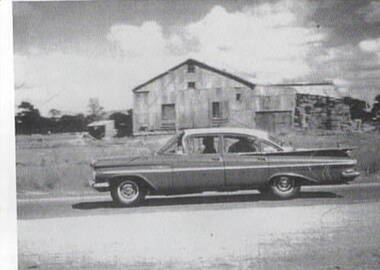
Photograph, Hay shed, c1960s
The hay shed was sited on railway land fronting onto Evans Street and near Station Street. Retail shops including Harris Scarf now occupy the site. The pine trees in the background were along Horne Street.The hay was stored in this building before being transported.Cereal growing was one of the agricultural activities carried out in the Sunbury area.A scanned print of an old black and white photograph of a corrugated shed with hay bales stacked at the rear of the building. A 1960s sedan car is parked in front of the building and there is a smaller shed in the background.hay shed, railways, sunbury station, evans street, horne street -
Bendigo Historical Society Inc.
Document - Jonathan Harris / Axedale
Jonathan Harris was born in Sussex England in 1822. His father Jonathan Snr was transported to Australia and his wife obtained permission to follow him as a free settler when Jonathan jnr was about 7 yrs.In 1842, Jonathan snr (who held a ticket of leave) and his son Jonathan Jnr were found guilty of theft and transported to Tasmania. Family history suggests that following his term, Jonathan jnr became a police detective before returning to Victoria. He and his wife had a store at Third White Hill in Bendigo and one day while walking to Eaglehawk, Jonathan found a rich vein of gold in what was to become the Hustlers Mine. He took large samples to England for crushing and subsequently sold his claim. Upon returning to Melbourne he conducted a business before taking up land at Axedale. He farmed here, including the growing of apples up until his death 20/7/1881. His efforts must have been successful as following his death the sale of property at Axedale included two pieces of land that each had two cottages that had been rented out. Jonathan was also on the board of the Axedale School.An eight page document with newspaper articles and information about the life of Axedale man Jonathan Harris.jonathon harris, axedale, mining. -
 Kew Historical Society Inc
Biographical information, Ronald Horace Setford (1915–1988)
Ronald Horace Setford was born in April 1915 at 18 Church Street, Hawthorn, at his family’s home above their decorator shop. He was the second of three sons born to Horace Turner Setford (1880-1944) and Mabel Crofts (1887-1943). He attended Hawthorn West Primary School and then Swinburne before beginning work in his family’s business ‘Setford and Son’ in October 1930. This was formalised in April 1931 when he became a carpentry and joinery apprentice. In 1934 he graduated as a grade four carpenter. Ron worked in the family business until 1964 and then worked at J S Kidd and Co Pty Ltd as a storeman until his retirement in December 1973. Ron married Grace Muriel Agnes Perrey (1915-2001) in 1936 and they first lived in Kew around 1940, at 38 Marshall Avenue. Ron served in the Citizen Military Forces as a sapper with the 9 Australian Army Transport Company, Royal Australian Engineers, signing up a week after Darwin had been bombed. He spent time in Darwin, Wayville (South Australia), Herberton and Grovely (Queensland). Afterwards he refused to eat rice, never spoke of the war, nor took part in any ANZAC day proceedings. In 1941, Ron and Grace bought their block of land at 9 Tanner Avenue, East Kew, part of the Old Golf Links Estate, for £225. It was not until December 1945 that Ron started building their home and they moved in during May 1947. Ron and Grace remained there for thirty-seven years until the house was sold to their nephew in 1984. It has since been demolished. Ron’s great passion was photography and in the early 1960s he purchased his Minolta camera. Slide evenings at Tanner Avenue were a regular occurrence. Ron made his own title slides, interval slides and end slides. As well as many holiday photos (around Australia and their world trip in 1966), he enjoyed photographing local landmarks, flowers, insects and family. One of Ron’s photography projects was to record the progress of the building of the Eastern Freeway. This was near their home, and he’d walk down to the works on a regular basis, dressed smartly, with his camera in hand. The workers thought he was an official photographer, and he was allowed on site to take his photos. In 1984, Ron and Grace downsized and moved to Bayswater. Ron passed away on 31 October 1988 at the Maroondah Hospital in Ringwood East, at age 73. His ashes were spread on his beloved rose bushes at Tanner Avenue. Lauren Thomson, 2025ron setford, 9 tanner avenue -- kew east (vic, setford and son -- 18 church st (hawthorn), grace muriel agnes perrey, 9 australian army transport company, j s kidd and co pty ltd, eastern freeway, f19 freeway -
 Hymettus Cottage & Garden Ballarat
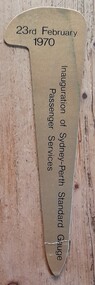
Work on paper - Bookmark, Inauguration of Sydney-Perth standard Gauge Passenger Services
Originally transport between Australia's eastern and western capitals was by coastal steamer. Rail links were by way of Melbourne and Adelaide as were most road links prior to 1970. Air travel became the most popular link until 1970 when this rail service became available.Inauguration of Sydney-Perth standard Gauge Passenger Services on 23 February 1970 was a major step in linking Australia's east and west coast by land.railways, train travel, isolation, -
 Bendigo Military Museum
Manual - PRECIS, LANDROVER 110 (6x6) Specifications, Army logistics Training Centre - Transport Wing, 1996
This is an owner's manual for model 110 land rover (6 x 6). It shows equipment layout, weights CTC, It looks like a "Local" copy on foolscap - orange paper. It has an outline drawing of a 6 x 6 land rover with canopy. It is bound with 1 staple in top LH corner. At the bottom are words "Driver Trg Precis - October 96"passchendaele barracks trust, land rover 110, owners manual -
 Narre Warren and District Family History Group
Booklet, Narre Warren & District Family History Group Inc, Casey Cardinia Collection - Nar Nar Goon Information File, 2005
Nar Nar Goon, a town in Gippsland, Victoria, has a rich history dating back to the mid-19th century. Originally part of the Kulin nation, the area was home to the Boon Wurrung people. The name "Nar Nar Goon" is believed to come from a Boonwurrung word referring to either the koala or the rakali. European settlement began with the establishment of the Mount Ararat pastoral run in 1844, followed by land sales in the 1850s and 1860s. Many settlers came from Ireland, particularly from the Monteagle estate in Limerick. The arrival of the railway in 1881 was a turning point, facilitating timber and agricultural industries. Several sawmills operated in the area, transporting timber via wooden tramways to the railway station. By the early 20th century, Nar Nar Goon had developed into a thriving township with a general store, hotel, butcher, baker, and garage. The town had strong Catholic roots, with a church opening in 1905. Over time, timber milling declined, and dairy farming became the dominant industry. In 2021, part of Nar Nar Goon was annexed to form the new suburb of Pakenham East. Today, Nar Nar Goon is known for its murals, historical buildings, and community spirit. It remains a small but significant town in Victoria’s history. [AI generated text]Display book containing a table of contents and various newspaper clippings and other information pertaining to the Nar Nar Goon area.non-fictionnar nar goon (vic.), nar nar goon (vic.) -- history, bernie byrne, jack egan, mark & sylvia jones, daisy lia, bill doherty, michael o'brien, joan & frank lindsay, paddy henwood, bob rose, harry james, ray coombs, jack payroll, deb bramley, nar nar goon-maryknoll cricket club, john byrne, bernie dingle, jan van steensel, len & mary bramley, kylie shanks, bill bickerton, james dore, red gem potatoes, brydie cunningham -
 Whitehorse Historical Society Inc.
photograph - photocopy, Jones Flower Farm
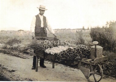
In 1905 Walter Jones bought twenty five acres of land in Mt Pleasant Road Nunawading South to establish a flower farm. Plants and flowers were transported to the city by rail. In 1957 some of the land was sold to the Education Dept to erect the Nunawading South Primary School.Black and white copy of Walter Jones with a barrow load of flowers.walter jones, jones flower farm. -
 Dandenong & District Historical Society
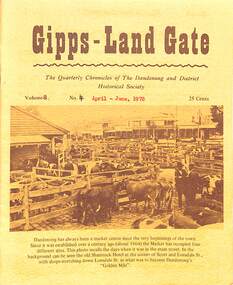
Journal, Dandenong & District Historical Society, Gipps-Land Gate Vol.6 No.4b, 1978
An interesting group of Early Dandenong Personalities, Places and EventsA5 size publication of the Gipps-Land Gate, April - June 1978. 16 pages, featuring an old picture of Dandenong on the cover. Keeping Posted Garner and Sons Wheelrights and General Blacksmiths Harking Back 75 Years Ago Sixty-Five Years In Local Transport With The Paydons An interesting group of Early Dandenong Personalities, Places and Eventshotel history, early education in dandenong, interesting milestones, family histories -
 Eltham District Historical Society Inc
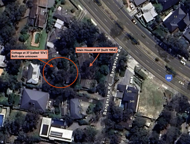
Document - Property Binder, 338 Main Road, Lower Plenty (also 37 Rangeview Road), March 2025
EDHS_03095-338 | EDHS_08635-37 338 Main Road Lower Plenty | 37 Rangeview Road, Lower Plenty Original Mudbrick cottage and studio designed and built by Eltham artist, David Alan Newbury See also EDHS_06090 David Newbury (Artist) David Newbury was married to Clare Margaret Newbury. According to the 1954 Electoral Roll they were living at 36A Murphy Street, South Yarra however around 1953 they purchased Lots 3 and 4 of Main Road Lot Plan LP 23911 in Lower Plenty. A building permit, No. 71, was issued 8 December 1953 for a 5-room house of Vertical Board construction, cost £2,840, builder L. Williams, owner D. Newbury of 36 Murphy Cl., South Yarra. The large house was in fact mostly built of mudbrick, the construction method was only just becoming recognised as an acceptable form in the late 1940s for issuance of a building permit. The house was commenced in 1954, designed by David Newbury and built by David Newbury, Horrie Judd and others. Information from Newbury family friends suggests that a second mudbrick building was constructed in the late 1950s, early 1960s for use as an artist studio by Newbury. The building was connected directly to the water mains at the time and was made suitable for living accommodation during the period Newbury was teaching at Bendigo. Apparently he and Claire rented out the main house during their time in Bendigo and would reside in the studio when visiting Melbourne. No permit for this studio was found in the Building Permit Register, Shire of Eltham, 1949-1960. The last recorded entries in the register are dated May 1960. This would suggest that the studio was constructed post May 1960. It is believed the studio was constructed during the latter period of Newbury’s teaching post in Bendigo so possibly late 1960/1961. In 1963 the Newbury’s address in the Electoral Roll has the property recorded as 220 Main Road, Lower Plenty. Between 1967 to 1980 the Electoral Rolls record the property as 338 Main Road. Today the address is 37 Rangeview Road, Lower Plenty. Contents: 1. Extract from 1942 Shire of Eltham Rate Book. Muriel Gladys Reitsma listed as owner 2. Extract from 1984-85 Shire of Eltham Rate Book for Rangeview Road. (No mention of No. 37 so was probably still listed as 338 Main Road.) 3. Certificate of Title, Vol. 5601 Fol. 1120089 - Issued to David James Graham of Lower Plenty, Builder, Heidelberg for Lot 32 Block B on Plan of Subdivision No. 7606, part of Crown Portion Two, Parish of Nillumbik, County of Evelyn, 29 October 1929 4. Certificate of Title, Vol. 8008 Fol. 076 - Issued to David Alan Newbury of 36 Murphy Street, South Yarra, School Teacher for Lot 3 on Plan of Subdivision No. 23911, part of Crown Portion Two, Parish of Nillumbik, County of Evelyn, 29 October 1953. Amended 24 June 1963 to transfer portion for road widening scheme per Country Roads Board Plan 6889 - Cancelled 24 September 1984 5. Certificate of Title, Vol. 9581 Fol. 583 - Issued to Paul Robert Biber and Althea Constance Biber of 139 Lower Heidelberg Road, Ivanhoe for Lot 3 on Plan of Subdivision No. 23911, part of Crown Portion Two, Parish of Nillumbik, County of Evelyn, 24 September 1984. Derived from Vol. 8008 Fol. 076 L276994V - Cancelled 20 Nov 1992 when subdivided from one to two lots in Vol 10092 Fol. 192 and Vol. 10092 Fol. 193; LP222467B 6. Certificate of Title, Vol. 10092 Fol. 192 - Transfer to Lawrie Mein of 20 Dewar Drive, Hurstbridge of Lot 1 on Plan of Subdivision No. 222467B, lodged 17 Feb 1993, Registered 29 March 1996. Parent Titles Vol 08008 Fol 077, Vol 09581 Fol 583 7. Survey Field Notes of Part of Crown Portion 2, Parish of Nillumbik, County of Evelyn - Portion of land bounded by New Eltham Road. Application 23911 dated 8 Sep 1952 with appended Surveyor Field notes per Application 7098; R.D. Steele, Licensed Surveyor, 18 August 1950 8. Survey Field Notes of Part of Crown Portion 2, Parish of Nillumbik, County of Evelyn - Portion of land bounded by Main Road and Rangeview Road; 2 Lot subdivisions, Vol. 9581 Fol. 583 Part Lot 3 on LP 23911 and Vol. 8008 Fol, 077 Lot 4 on LP 23911; Application 221805 dated 27 November 1989; W.J. Goodison, Licensed Surveyor, and attached Surveyor's Report dated 6 June 1990 (Withdrawn) 9. Survey Field Notes of Part of Crown Portion 2, Parish of Nillumbik, County of Evelyn - Portion of land bounded by Main Road and Rangeview Road; 2 Lot subdivisions, Vol. 9581 Fol. 583 Part Lot 3 on LP 23911 and Vol. 8008 Fol, 077 Lot 4 on LP 23911; Application 222467 dated 20 November 1992 (221805 resubmitted); W.J. Goodison, Licensed Surveyor, and attached Surveyor's Report dated 6 June 1990 Notes: Items 1 to 6 donated electronically Items 7 to 9 sourced from LASSI - SPEAR, Department of Transport and Planning, Victoria State Government, https://maps.land.vic.gov.au/lassi/SpearUI.jsp main road, property, mudbrick, david newbury, phoebe mason collection, rate books, shire of eltham, certificate of title, survey plan, 37 rangeview road, 338 main road, application 23911, lower plenty, map, surveyor field notes, application 221805, application 222467