Showing 523 items
matching lands department
-
 Bendigo Historical Society Inc.
Map - SALISBURY : COUNTY OF BENDIGO, 1965
... at the Department of Lands and Survey, Melbourne. Price $1.00. 1965..., Yarrayne, Bullock Creek. Drawn and reproduced at the Department ...Map. Salisbury, County of Bendigo, Pompapiel, Yallook, Yarraberb, Yarrayne, Bullock Creek. Drawn and reproduced at the Department of Lands and Survey, Melbourne. Price $1.00. 1965. By authority A.C. Brooks, Government Printer, Melbourne. (number 28 in map cupboard 1)A.C. Brooks,Government Printer, Melbourne.map, bendigo, salisbury -
Bendigo Historical Society Inc.
Map - WANURP : COUNTY OF BENDIGO, 1-12-33
... Printer.Photo-Lithographed at the Department of Lands and Survey... at the Department of Lands and Survey, Melbourne. Price 2/-. 1-12-33 ...Map. Wanurp, County of Bendigo, Terrick Terrick East, Mitiamo, Milloo, Pannoobamawm. By authority H.J. Green, Government Printer.Photo-Lithographed at the Department of Lands and Survey, Melbourne. Price 2/-. 1-12-33. (number 9 in map cupboard 1)H.J. Green, Government Printermap, bendigo, wanurp -
Bendigo Historical Society Inc.
Map - TALAMBE : COUNTY OF BENDIGO, January 1956
... , Melbourne. Drawn and reproduced at the Department of Lands... and reproduced at the Department of Lands and Survey, Melbourne. January ...Map. Talambe, County of Bendigo, Hayanmi, Pompapiel, Dingee, Tandarra, Yallook. By authority W.M. Houston, Government Printer, Melbourne. Drawn and reproduced at the Department of Lands and Survey, Melbourne. January 1956. Price 2/-. (number 8 in map cupboard 1)W.M. Houston, Government Printermap, bendigo, talambe -
Bendigo Historical Society Inc.
Map - SALISBURY : COUNTY OF BENDIGO, 1965
... , Government Printer, Melbourne. Drawn and reproduced at the Department..., Melbourne. Drawn and reproduced at the Department of Lands ...Map. Salisbury, County of Bendigo, Pompapiel, Yarrayne, Yarraberb, Yallook, Bullock Creek. By Authority: A.C. Brooks, Government Printer, Melbourne. Drawn and reproduced at the Department of Lands and Survey, Melbourne.1965. Price $1.00. (number 6 in map cupboard 1)A.C. Brooks, Government Printermap, bendigo, salisbury -
Bendigo Historical Society Inc.
Map - DERBY : COUNTY OF BENDIGO, 1959
... at the Department of Lands and Survey, Melbourne. 1959. Price 2/-. (number..., Government Printer, Melbourne. Drawn and reproduced at the Department ...Map. Derby, County of Bendigo, Bridgewater, Inglewood, Tarnagulla, Woodstock, Leichardt, Loddon River. By authority A.C. Brooks, Government Printer, Melbourne. Drawn and reproduced at the Department of Lands and Survey, Melbourne. 1959. Price 2/-. (number 54 in map cupboard 1)A.C. Brooks, Government Printer, Melbourne.map, bendigo, derby -
Bendigo Historical Society Inc.
Map - YALLOOK : COUNTY OF BENDIGO, 30-1-28
... at the Department of Lands and Survey, Melbourne, Victoria. 30-1-28. H.J..., Salisbury, Pompapiel. Drawn and reproduced at the Department ...Map. Yallook, County of Bendigo, L4942, Talambe, Tandarra, Neilborough, Yarraberb, Salisbury, Pompapiel. Drawn and reproduced at the Department of Lands and Survey, Melbourne, Victoria. 30-1-28. H.J. Green, Govt. Printer, Melbourne. (number 18 in map cupboard 1)H.J. Green, Govt. Printer.map, bendigo, yallook -
Bendigo Historical Society Inc.
Map - COSTERFIELD : COUNTY OF BENDIGO, 31-10-12
... of Costerfield. Photo-Lithographed at the Department of Lands and Survey..., Heathcote, Town of Costerfield. Photo-Lithographed at the Department ...Map. Costerfield, County of Bendigo, County of Dalhousie, Dargile, Moorambool West, Warrowitue, Heathcote, Town of Costerfield. Photo-Lithographed at the Department of Lands and Survey, Melbourne, by W.J .Butson 31-10-12 price 1/-. (number 93 in map cupboard 1)W.J. Butsonmap, bendigo, costerfield -
University of Melbourne, Burnley Campus Archives
Plan, Plan of Richmond Park, 1872
... . Photo-lithographed at the Department of Lands and Survey, 6th..., Authorized Surveyor. Photo-lithographed at the Department of Lands ...Plan of Richmond Park L4461. Shows Horticultural Society's Garden without extra land used for Field Station (see 11.0363, but earlier). Surveyed and drawn by A.L. Martin, Authorized Surveyor. Photo-lithographed at the Department of Lands and Survey, 6th Sept. 1872.Handwritten notes on reverse and another railway line marked in pencil.railway lines, swan street, yarra river, richmond park, horticultural society, orchard -
Stawell Historical Society Inc
Map, Borough of Stawell Parish of Stawell and Illawarra 10/06/1903, 10/06/1903
... Department of Lands and Survey Map of Stawell with marked...Department of Lands and Survey... grampians Department of Lands and Survey Map of Stawell with marked ...Department of Lands and Survey Map of Stawell with marked roads, allotments, physical landmarks. Found in Storage at ANZ Bank when the old archive was being cleaned out. Also shows Surveyed but unused roads. Showed where customers lived in StawellPholtolithograph Map - Paper on canvas backingBorough of Stawell. Parish of Stawell and Illawarra. County of Borong. Scale 8 Chains to 1 Inch. Scale 16 Chains to 1 Inch. Red Ink Writing, Purple and Blue.town -
 Kiewa Valley Historical Society
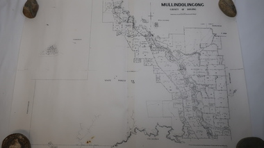
Map - Mullindolingong
... River and beyond.Produced by the Department of Lands and Survey... River and beyond.Produced by the Department of Lands and Survey ...Land owners of land in the Kiewa Valley in 1928The Kiewa Valley was farming country with families settling in the area prior to 1928 Two sheets the same: (one old with paper joined together and the other is a copy without any joins. 21 6 1928 dated Map of Mullindolingong / County of Bogong showing land owners along the Kiewa River and beyond.Produced by the Department of Lands and Survey, Melbournemullindolingong, kiewa valley, land owners, families of the kiewa valley -
Bendigo Historical Society Inc.
Map - LYELL : COUNTY OF BENDIGO, 24-10-84
... School. Photo-Lithographed at the Department of Lands and Survey..., Myrtle Creek. State School. Photo-Lithographed at the Department ...Map. Lyell, County of Bendigo, Eppalock, Sedgwick, Sutton Grange, Hawkestone, Kimbolton, Coliban River, Myrtle Creek. State School. Photo-Lithographed at the Department of Lands and Survey, Melbourne by J. Noune, 24-10-84. (number 71 in map cupboard 1)J. Nounemap, bendigo, lyell -
Bendigo Historical Society Inc.
Map - LYELL : COUNTY OF BENDIGO, 24-9-07
... -Lithographed at the Department of Lands and Survey, Melbourne by T.F... Creek, Coliban River. Photo-Lithographed at the Department ...Map. Lyell, County of Bendigo, Sedgwick, Sutton Grange, Hawkestone, Kimbolton, Eppalock, Myrtle Creek, Coliban River. Photo-Lithographed at the Department of Lands and Survey, Melbourne by T.F. McGauran, 24-9-07, Price 1/-. (number 70 in map cupboard 1)T.F. McGauranmap, bendigo, lyell -
Bendigo Historical Society Inc.
Map - LOCKWOOD : COUNTY OF BENDIGO, 2=7-18
... , Ravenswood, Mandurang. Photo- Lithographed at the Department of Lands..., Mandurang. Photo- Lithographed at the Department of Lands and Survet ...Map. Lockwood, County of Bendigo. Marong, Shelbourne, Ravenswood, Mandurang. Photo- Lithographed at the Department of Lands and Survet, Melbourne by W.J. Butson 2-7-18. By authority A.J. Mullett, Government Printer, Melbourne. Price 1/-. (number 69 in map cupboard 1)A.J. Mullett, Government Printer, Melbourne.map, bendigo, lockwood -
Bendigo Historical Society Inc.
Map - LEICHARDT : COUNTY OF BENDIGO, 15-6-19
... Line. Photo-Lithographed at the Department of Lands and Survey... & Inglewood Railway Line. Photo-Lithographed at the Department ...Map. Leichardt, County of Bendigo, Bridgewater, Yarraberb, Nerring, Marong, Woodstock, Derby, Sandhurst & Inglewood Railway Line. Photo-Lithographed at the Department of Lands and Survey, Melbourne, by T.F. McGauran, 15-6-09. Price 1/-. (number 68 in map cupboard 1)T.F. McGauranmap, bendigo, leichardt -
Bendigo Historical Society Inc.
Map - YARRAYNE : COUNTY OF BENDIGO, 6-1-32
... at the Department of Lands and Survey, Melbourne. Price 2/-. 6-1-32..., Salisbury West, Powlett. Photo-Lithographed at the Department ...Map. Yarrayne, County of Bendigo, Janiember Easr, Pompapiel, Salisbury, Bridgewater, Salisbury West, Powlett. Photo-Lithographed at the Department of Lands and Survey, Melbourne. Price 2/-. 6-1-32.By authority H.J. Green, Govt.Printer. (number 31 in map cupboard 1)H.J. Green, Govt.Printer.map, bendigo, yarrayne -
Bendigo Historical Society Inc.
Map - CORNELLA : COUNTY OF BENDIGO, 18-3-08
... Creek. Photo-Lithographed at the Department of Lands and Survey... at the Department of Lands and Survey, Melbourne by T.F. McGauran. 18-3-08 ...Map. Cornella, County of Bendigo, County of Rodney, Colbinabbin, Gobarup, Redcastle, Toolleen, Cornella Creek, Kangaroo Creek. Photo-Lithographed at the Department of Lands and Survey, Melbourne by T.F. McGauran. 18-3-08. Price 1/-. (number 122 in map cupboard 1)T.F. McGauranmap, bendigo, cornella -
Bendigo Historical Society Inc.
Map - TALAMBE : COUNTY OF BENDIGO, January 1956
... Department of Lands and Survey, Melbourne. January 1956. Price 2..., Pompapiel, Calivil. Drawn and reproduced at trhe Department of Lands ...Map. Talambe, County of Bendigo, Hayanmi, Dingee, Tandarra, Yallook, Pompapiel, Calivil. Drawn and reproduced at trhe Department of Lands and Survey, Melbourne. January 1956. Price 2/-. By authority W.M. Houston, Government Printer, Melbourne. (number 23 in map cupboard 1)W.M. Houston,Government Printer, Melbourne.map, bendigo, talambe -
Bendigo Historical Society Inc.
Map - DERBY : COUNTY OF BENDIGO, 1-9-09
... Railway. Photo-Lithographed at the Department of Lands and Survey... at the Department of Lands and Survey, Melbourne, by T.E. McGauran 1-9-09 ...Map. Derby, County of Bendigo, Inglewood, Loddon River, Tarnagulla, Woodstock, Leichardt, Bridgewater, Bendigo to Inglewood Railway. Photo-Lithographed at the Department of Lands and Survey, Melbourne, by T.E. McGauran 1-9-09. Price 1/-. (number 55 in map cupboard 1)T.E. McGauranmap, bendigo, derby -
Bendigo Historical Society Inc.
Map - HUNTLY : COUNTY OF BENDIGO, August 1954
... and reproduced at the Department of Lands and Survey, Melbourne, Victoria..., Township of Huntly. Drawn and reproduced at the Department of Lands ...Map. Huntly, County of Bendigo. Whirrakee, Bagshot, Wellsford, Nerring, Neilborough, Township of Huntly. Drawn and reproduced at the Department of Lands and Survey, Melbourne, Victoria. August 1954. Price 2/-. By authority W.M. Houston, Government Printer. (number 42 in map cupboard 1)W.M. Houston, Govt. Printer.map, bendigo, huntly -
Bendigo Historical Society Inc.
Map - TALAMBE : COUNTY OF BENDIGO, 17-12-15
... , Yallook, Pompapiel. Photographed at the Department of Lands..., Yallook, Pompapiel. Photographed at the Department of Lands ...Map. Talambe, County of Bendigo, Hayanmi, Dingee, Tandarra, Yallook, Pompapiel. Photographed at the Department of Lands and Survey, Melbourne by W.J. Butson,17-12-15, Price 1/-. Albert J. Mullett, Govt. Printer, Melbourne. (number 17 in map cupboard 1)Albert J. Mullett, Government Printer, Melbourne.map, bendigo, talambe -
Bendigo Historical Society Inc.
Map - PANNOOBAMAWM : COUNTY OF BENDIGO, 1957
... at the Department of Lands and Survey, Melbourne. Price 2/-.1957..., Government Printer, Melbourne. Drawn and reproduced at the Department ...Map. Pannoobamawm, County of Bendigo. By Appointment W.M. Houston, Government Printer, Melbourne. Drawn and reproduced at the Department of Lands and Survey, Melbourne. Price 2/-.1957. Turrumberry, Terrick Terrick East, Wanurp,Pannoomilloo, Bamawm, Pannoobamawm. (number 2 in map cupboard 1)W.M. Houston, Government Printermap, bendigo, pannoobamawm -
Bendigo Historical Society Inc.
Map - NERRING : COUNTY OF BENDIGO, August 1952
... at the Department of Lands and Survey, Melbourne,Victoria. August 1952..., Leichardt, Marong. Drawn and reproduced at the Department of Lands ...Map. Nerring, County Of Bendigo. Yarraberb, Neilborough, Huntly, Sandhurst, Leichardt, Marong. Drawn and reproduced at the Department of Lands and Survey, Melbourne,Victoria. August 1952, Price 2/-. By Appointment J.J. Gourley, Government Printer, Melbourne. (number 0 in map cupboard 1)J.J. Gourley,Government Printermap, bendigo, nerring -
 Bendigo Historical Society Inc.
Map - MARKS COLLECTION: MAP SANDHURST 1867
... for. On bottom of map: 'Lithographed at the Department of Lands... at the Department of Lands and Survey by D. Henderson, 20 February, 1867 ...Original map: Sandhurst 1867, shows central Bendigo and surrounds, including police camp, stockade, 'old cemetery', reserve for. On bottom of map: 'Lithographed at the Department of Lands and Survey by D. Henderson, 20 February, 1867'. On top RH corner 'Sheet No 1 Sandhurst'.map, bendigo, 1867 sandhurst map -
Bendigo Historical Society Inc.
Map - HEATHCOTE : COUNTY OF BENDIGO, 19-2-1942
... , Government Printer, Melbourne. Drawn and reproduced at the Department... Printer, Melbourne. Drawn and reproduced at the Department ...Map. Heathcote, County of Bendigo. County of Dalhousie, McIvor Creek,Wallan and Bendigo Railway, By authority H.E. Daw, Government Printer, Melbourne. Drawn and reproduced at the Department of Lands and Survey, Melbourne. 19-2-1942. Price 2/-. (number 90 in map cupboard 1)H.E. Daw, Government Printer, Melbourne.map, bendigo, heathcote -
Bendigo Historical Society Inc.
Map - PARISH OF STRATHFIELDSAYE : COUNTY OF BENDIGO, 1-10-19
... -Lithographed at the Department of Lands and Survey, Melbourne... at the Department of Lands and Survey, Melbourne by W.J.Butson, 1-10-19 ...Map. Parish of Strathfieldsaye, County of Bendigo, Wellsford, Sandhurst, Sedgwick, Eppalock, Axedale. Photo-Lithographed at the Department of Lands and Survey, Melbourne by W.J.Butson, 1-10-19. Price 1/-. By authority A.J. Mullett, Government Printer, Melbourne. (number 34 in map cupboard 1)A.J. Mullett, Govt. Printer, Melbourne.map, bendigo, strathfieldsaye -
Bendigo Historical Society Inc.
Map - SEDGWICK : COUNTY OF BENDIGO, 1963
... and reproduced at the Department of Lands and Survey, Melbourne.1963... at the Department of Lands and Survey, Melbourne.1963, Price 2/-. (number 30 ...Map. Sedgwick, County of Bendigo, Strathfieldsaye, Mandurang, Sutton Grange, Lyell, Eppalock County of Talbot Border. By authority A.C. Brooks, Government Printer, Melbourne. Drawn and reproduced at the Department of Lands and Survey, Melbourne.1963, Price 2/-. (number 30 in map cupboard 1)A.C. Brooks, Government Printer, Melbourne.map, bendigo, sedgwick -
Bendigo Historical Society Inc.
Map - SEDGWICK : COUNTY OF BENDIGO, 18-12-20
... at the Department of Lands and Survey, Melbourne by W.j. Butson 18-12-20... Grange, Lyell, Eppalock. Photo-Lithographed at the Department ...Map. Sedgwick, County of Bendigo,Strathfieldsaye, Mandurang, Sutton Grange, Lyell, Eppalock. Photo-Lithographed at the Department of Lands and Survey, Melbourne by W.j. Butson 18-12-20, Price 1/-. By authority A.J.Mullett, Government Printer, Melbourne. (number 29 in map cupboard 1)A.J. Mullett, Government Printer,Me;bourne.map, bendigo, sedgwick -
 Bendigo Historical Society Inc.
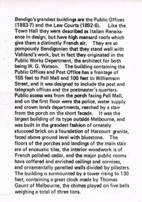
Document - LETTER DESCRIBING BENDIGO'S GRANDEST BUILDINGS
... they originated in the Public Works Department, the architect for both... and crown lands departments, reached by a stair from the porch ...Bendigo's Grandest Buildings are the Public Offices (1883-7) and the Law Courts (1892-6). Like the Town Hall they were described as Italian Renaissance in Design, but have high mansard roofs which give them a distinctly French air. They are so pompously Bendigonian that they stand well with Vahland's work, but in fact they originated in the Public Works Department, the architect for both being W.G. Watson. The building containing the Public Offices and Post Office has a frontage of 155 feet to Pall Mall and 100 feet to Williamson Street, and it was designed to include the post and telegraph offices and the postmaster's quarters. Public access was from the porch facing Pall Mall, and on the first floor were the police, water supply and crown lands departments, reached by a stair from the porch on the short façade. It was the largest building of its type outside of Melbourne, and was built in the grandest fashion of ornately stuccoed brick on a foundation of Harcourt granite, faced above ground level with bluestone. The floors of the porches and landings of the main stair are of encaustic tiles, the interior woodwork is of French polished cedar, and the major public rooms have coffered and enriched ceilings and cornices, and ornamentally panelled walls divided by pilasters. The building is surmounted by a tower rising to 130 feet, containing a great clock made by Thomas Gaunt of Melbourne, the chimes played on five bells weighing a total of three tons.bendigo, buildings, state offices -
 Ballan Shire Historical Society
Map - Map. Bungal, Department of Lands and Survey, Bungal, County of Grant, 09/09/1926
... and the number L.358. Lithographed at the Department of Lands and Survey...Department of Lands and Survey.... at the Department of Lands and Survey. Melbourne by W. J. Butson on 9.9.1926 ...A map of Bungal in the 1920's showing the allotments, and the size, with the names of the residents. It shows the roads and the Western and Eastern Moorarbool River, and the Whipstick State Forest.Cream coloured map of Bungal in the County of Grant, bounded by the the East Moorarbool River on the East, and the State Forest on the South. It is marked with the scale of chains and the number L.358. Lithographed at the Department of Lands and Survey. Melbourne by W. J. Butson on 9.9.1926. It shows the land allotments with names of owners.Coloured pen marks and circled numbers on various areas. Price 2 shillings marked on bottom right hand edge.bungal, kerrit bareet, egerton, lal lal, borhoneyghurk, bungeeltap, ballark, yaloak, gorong, moorarbool west -
Bendigo Historical Society Inc.
Map - PANNOOMILLOO : COUNTY OF BENDIGO, 1957
... and reproduced at the Department of Lands and Survey, Melbourne 1957... and reproduced at the Department of Lands and Survey, Melbourne 1957 ...Map. Pannoomilloo, County of Bendigo, Pannoobamawm, Milloo, Diggorra, Warragamba. Elmore Cohuna Railway. Waranga Mallee Channel. By authority W.M. Houston, Government Printer, Melbourne. Drawn and reproduced at the Department of Lands and Survey, Melbourne 1957. Price 2/-. (number 83 in map cupboard 1)W.M. Houston, Government Printer, Melbourne.map, bendigo, pannoomilloo