Showing 172 items matching "lines plan"
-
 Melbourne Tram Museum
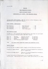
Document - Notice, The Met, "North/South LRT route - Port Melbourne Opening", 11/12/1987
Set of Notices to crews associated with the opening of the Port Melbourne Light Rail Line, following its conversion from a Heavy rail line. Signed by Dennis Griffiths, Manager Tram Operations - Western. C5043 - gives details of the route, tram stops, route numbers, traffic signals and T lights, running times, toilet facilites, time clocks and track telephones. Dated 16/12/1987 C5044 - details the new types of automatic points at Flinders and Spencer Sts and Clarendon and Whiteman streets - their operation, associated signals and a layout plan. Dated 22/12/1987 C5046 - Installation of automatic points - Whiteman St Y Junction - later known as Port Junction - St Kilda - Port Melbourne lines - dated 22/12/1987 Interoffice memo to Conductors - Preston and North Fitzroy depot routes - regarding section points on the Port Melbourne and St Kilda light rail routes. Dated 25/6/1987 - signed by Ray Stock, Manger Revenue Systems.Yields information about the opening of the Port Melbourne line in 1987.Set of 7 A4 sheets stapled in top left hand corner.tramcars, tramways, port melbourne, opening, new tramway, points, operations, fares, signals -
 Melbourne Tram Museum
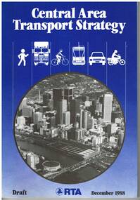
Document - Report, Road Traffic Authority, "Central Area Transport Study", Dec. 1988
Report - 108 pages + card cover, centre stapled, titled "Central Area Transport Study", produced by the Road Traffic Authority as part of the Central Area Transport Strategy (CATS), with a forward by the Minister for Transport Jim Kennan, has a table of contents, figures and tables. Provides a set of Action Plans, looks at future development areas around Melbourne, options, roads, tram and rail lines, cycle and pedestrians. Draft document. See Reg Item 1582 for a March 1991 version.Has pen marks high lighting various paragraphs.trams, tramways, public transport, melbourne, road transport, the met, minister for transport -
 Melbourne Tram Museum
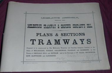
Document - Folder, Jack Cranston, "Melbourne Tramway & Omnibus Company's Bill - Plans and Sections - Tramways - March 1882", 1994
Consists of five sheets with notes about the proposed horse tram system for Melbourne, prepared by Jack Cranston. Includes extract and notes on the parliamentary enquiry and the possibility of a cable tram system. The coloured sheet is from another copy held at the former VicTrack Malvern Museum. Images from the latter set of documents - Sept 2024. 35 Sheets of details on the plans and sections of proposed horse tram lines throughout Melbourne. Produced as part of the work undertaken by Jack Cranston for the Department of Transport / Heritage Victoria - see Reg Item 584. On rear cover ink and on page 2 of the folder is a note on the source of the document. See Inscriptions.Yields information about the proposed horse tram lines by MTOCo that were later developed as cable tram lines.Folder - photocopies or copy prints, A1 approx. size, 45 sheets, clipped together with two black side binders, titled - "Melbourne Tramway & Omnibus Company's Bill - Plans and Sections - Tramways - March 1882". On rear cover sheet, handwritten in black ink - "Constructed and compiled by Jack Cranston by permission from The Ambleside Museum Ferntree Gully Victoria. This is a copy of Original Size Folio"trams, tramways, cable trams, horse trams, mto co, melbourne -
 Melbourne Tram Museum
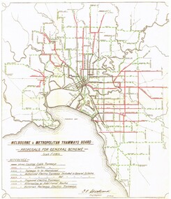
Document - Photocopy, "MMTB Proposals for General Scheme, c1970
Colour photocopy of a MMTB drawing titled "MMTB Proposals for General Scheme showing a detail plan of tramways proposed for Melbourne 1923. Signed by J. Strickland 27-8-1923. Shows cable trams, existing tramways, authorised tramways, proposed, VR tramways, rail lines and waterways. Not known when colour copy actually made - could have been an AETA or a TMSV reproduction. See Reg Item 2089 for an original of this document.trams, tramways, mmtb, melbourne, cable trams, electric trains, tramways, proposals, planning -
![Map, Ballarat and Gordons Lane Plan of Land required [for railway line work]](/media/collectors/5e461d8021ea67224c82f2a1/items/676ff3a62c3783fe00b96a8d/item-media/676ff4a42c3783fe00b96cb6/item-fit-380x285.jpg) Bacchus Marsh & District Historical Society
Bacchus Marsh & District Historical SocietyMap, Ballarat and Gordons Lane Plan of Land required [for railway line work]
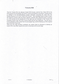
The railway line from Melbourne to Bacchus Marsh was completed in February 1887. After this date work continued to extend the line to Ballan. This map indicates a portion of land only a few hundred metres west of the Bacchus Marsh railway station which would have been among the first stages of the line to Ballan to have been constructed. This suggests the date of this map to be in the late 1880s.Single page map showing land required for railway line work near Griffith Street, Bacchus Marsh. Scale 10 chains to 1 inch. Hand-written on the map are the exact distances between Bacchus Marsh and Gordons (Gordon) and between Bacchus Marsh and Melbourne as measured from the corner of Maddingley Road and Station Street. Distances recorded are in miles, chains and links. The land required for the railway works is marked in red ink and runs through an area known as Kennedy's Gully. Part of a set of maps which are pasted into a bound volume containing 76 maps or plans in total. High resolution digital image stored on BMDHS computer network. bacchus marsh victoria history, maddingley victoria history, railway lines -
 Vision Australia
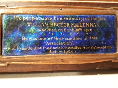
Unknown - Object, William Hector MacLennan memorial tablet, 1931
To commemorate the contribution of Mr MacLennan, this tablet was commissioned and on display in the foyer of the Braille Library in Commercial Road. It consists of a wooden frame, with a copper inset of Scottish thistles (to the left and right) and gum leaves and nuts (above and below) surrounding a sepia photograph of Mr MacLennan. A blue glass plate below the photograph reads "The social, friendly, honest man/ What e'ver he be/ 'Tis he fulfils great / Nature's plan / And none but he. Burns". To the left and right of this are accompanying blue glass plates with interwoven lines. At the base of the tablet is another blue glass plate: "To perpetuate the memory of the late/ William Hector MacLennan/ Who died on Sept. 18th 1929/ He was one of the founders of this Association/ and President of the Social Committee from its inception/ 1894-1929". Brown wooden memorial tablet with inset of copper and photograph victorian association of braille writers, william hector maclennan -
 University of Melbourne, Burnley Campus Archives
Plan - Photocopy, 1. [Botanic Gardens] upon the retirement of Baron Von Mueller from the Directorship, 1873. 2. Botanic Gardens, 1909, showing alterations and additions effected since 1873. By W.R. Guilfoyle. Director, c.1873-1909
Photocopies. (1) 2 copies, "[Botanic Gardens] upon the Retirement of Baron von Mueller from the Directorship, 1873." Source unknown, addition of 30 acres in 1875 noted. (2) 2 copies, "Botanic Gardens, 1909, showing alterations and additions effected since 1873 by W. R. Guilfoyle, Director." Source unknown. Shows grid lines.ferdinand von mueller, w.r. guilfoyle -
 Bendigo Historical Society Inc.
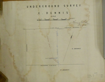
Plan - MARKS COLLECTION: PLAN OF UNDERGROUND SURVEY G. DENNIS MINE
... ' printed on top of plan. Plan shows boundary lines and peg site.... Plan shows boundary lines and peg site. P. Bonati claim marked ...Plan drawn on heavy parchment 'underground survey G. Dennis' printed on top of plan. Plan shows boundary lines and peg site. P. Bonati claim marked on bottom of plan. B. Letter with plan on letterhead 'City of Sandhurst, Town Hall, July 2nd. 1873' Addressed to Mr. George Dennis, Sir, In reply to your letter of the 19th. ulto I am empowered to state that subject to the formation of the road referred to, your existing rights are conserved, and the council will undertake not to object to the renewal of your lease. The only conditions being that you shall not sink a shaft in the street or attempt to obstruct it when formed. I have the honor to be, Sir, your obedient servant, Geo Fletcher, Town Clerk.bendigo, mining, g. dennis claim -
Canterbury History Group
Article - Residential Battle Lines, Progress Leader, 18 November 2014
Boroondara Council and Victorian Government representatives discuss stance on proposed planning zone changes in the area1 page newspaper article non-fictionBoroondara Council and Victorian Government representatives discuss stance on proposed planning zone changes in the arearesident action, boroondara council, town planning -
 Monbulk RSL Sub Branch
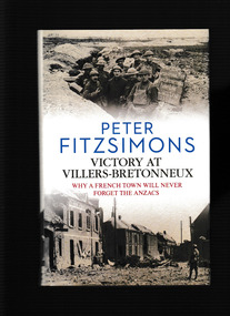
Book, Penguin Random House Australia Pty Ltd, Victory at Villers-Bretonneux : why a French town will never forget the Anzacs, 2016
It's early 1918, and after four brutal years, the fate of the Great War hangs in the balance. On the morning of 21 March 1918, the Kaiserschlacht (the Kaiser's battle) is launched. The biggest set-piece battle the world has ever seen. Across a 45-mile front, no fewer than two million German soldiers hurl themselves at the Allied lines, with the specific intention of driving all the way through to the town of Villers-Bretonneux, where their artillery can rain down shells on the key train hub of Amiens, thus throttling the Allied supply lines. For nigh on two weeks, the plan works brilliantly.The Germans are able to advance without check, as the exhausted British troops flee before them, together with tens of thousands of French refugees. In desperation, the British commander, General Douglas Haig, calls upon the Australian soldiers to stop the German onslaught and save Villers-Bretonneux. If the Australians can hold the line, the very gate to Amiens, then the Germans will not win the war. Arriving at Villers-Bretonneux just in time, the Australians launch a vicious counter-attack that hurls the enemy back the first time. And then, on Anzac Day 1918, when the town falls after all to the British defenders, it is again the Australians who are called on to save the day, the town, and the entire battle - even the warIndex, ill, bib, maps, p.764.It's early 1918, and after four brutal years, the fate of the Great War hangs in the balance. On the morning of 21 March 1918, the Kaiserschlacht (the Kaiser's battle) is launched. The biggest set-piece battle the world has ever seen. Across a 45-mile front, no fewer than two million German soldiers hurl themselves at the Allied lines, with the specific intention of driving all the way through to the town of Villers-Bretonneux, where their artillery can rain down shells on the key train hub of Amiens, thus throttling the Allied supply lines. For nigh on two weeks, the plan works brilliantly.The Germans are able to advance without check, as the exhausted British troops flee before them, together with tens of thousands of French refugees. In desperation, the British commander, General Douglas Haig, calls upon the Australian soldiers to stop the German onslaught and save Villers-Bretonneux. If the Australians can hold the line, the very gate to Amiens, then the Germans will not win the war. Arriving at Villers-Bretonneux just in time, the Australians launch a vicious counter-attack that hurls the enemy back the first time. And then, on Anzac Day 1918, when the town falls after all to the British defenders, it is again the Australians who are called on to save the day, the town, and the entire battle - even the war -
 Ballarat Tramway Museum
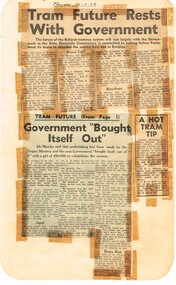
Newspaper, State Electricity Commission of Victoria (SEC) and The Courier Ballarat, Tram future rests with Government, Feb. 1962
Yields information about the views of various letter writers, views of the Courier, union views, rehabilitation costs Geelong, public meetings and meetings with SEC.Set of three Foolscap sheet of plain paper, with rounded corners, with newspaper cuttings, concerning the mooted closure of the Ballarat Tram system 20 Feb and 22 Feb 1962. All from The Courier, unless noted otherwise. 7940.1 1 - "Tram future rests with Government" - 22-2-62 - news report about the SEC being insistent on tabling the motion to close in Parliament, price of replacement trams. Attending Mr K L Murray, Mr Linaker, Mr A V Mawby of the SEC, Cr. A Pittard and Town Clerk Mr. H H Maddern. 2 - "Government "Bought itself out" - continuation from above, quoting Mr Mawby about the rehabilitation of the system in 1934 by the Government, discussions about fares, losses, time of travel from Sebastopol compared to buses. Also notes Cr Tuppen of Sebastopol. 3 - "A hot tram tip" - 22-2-62 - suggestion by Cr Cooper suggested the tram be retained around the lake for Historical reasons, Mr Murray of the SEC, sell/give to the Historical Society, Cr W E Roff replied about not wanting them and put them in a tip. 7940.2 1 - "SEC Not to sell this - 20-2-62 - photo of the power house in Ripon St, with the caption that the SEC did not propose to sell the property, but would be selling the tram depot site. 2 - "The talk was trams" - 22-2-62 - photo of Mr Mawby, Cr A D Mason, H Linaker and Mr K L Murray at the meeting with Council the previous day. 3 - "Save our Trams" - 21-2-62 - long letter - about the closing the trams and railway losses including building, new rail lines being built. 4 - "Tram fight" - letter by R Courtney Union Secretary, about the formation of a Committee to oppose closure. 7940.3 "Sound Shell Plan+ - 21-2-62 - Long editorial about the construction of a Sound Shell and council discussions and inability to make a decision.closure, letter to the editor, editorial, sec, rehabilitation, staff, buses, concession fares, museum, power station, ballarat a power station, botanical gardens -
 Bendigo Historical Society Inc.
Document - NEW CHUM & VICTORIA LINES OF REEF - NOTES ON VICTORIA HILL FOR TOURIST ATTRACTION
Handwritten notes outlining a plan for Victoria Hill, Central Nell Gwynne and New Chum Hill to be the focal position for a tourist attraction. Outlines steps to be taken to do the work and a mining museum at the Central Nell Gwynne. On the back of the page is a sketch of Victoria & New Chum Hills. On the plan is the Battery, Rae, Rae's House, Rae's Open Cut, Wittscheibe, Midway, Victoria Quartz, Lansell's 180 Shaft and the Recreation Reserve.document, gold, new chum & victoria lines of reef, central nell gwynne, new chum hill, bendigo and district tourist development association, victoria hill, lansell's big 180, victoria quartz, rae's open cut -
University of Melbourne, Burnley Campus Archives
Plan - Photocopy, Contour Map 1891, 1891
... Photocopy of plan showing contour lines from Yarra River... Gardens "Contour map 1891" written in biro Photocopy of plan ...Photocopy of plan showing contour lines from Yarra River. Shows Pavilion and Principal's Residence but not much of the garden design. From Central Plan Office Dept. of Natural Resources."Contour map 1891" written in biroyarra river, pavilion, burnley horticultural college, burnley gardens -
Canterbury History Group
Article, Victorian Railways, Big Grade Separation Job At Canterbury, May 1966
Article on the plans to duplicate the railway lines and raise the track at Canterbury2 pages includes black and white photosArticle on the plans to duplicate the railway lines and raise the track at Canterburyrailways, canterbury railway station, canterbury railway line -
 Bendigo Historical Society Inc.
Document - NEW CHUM & VICTORIA LINES OF REEF - NEW CHUM CONSOLIDATED COMPANY, S'HURST
Handwritten notes from Se? Mines Report Pages 46 & 47 on the Machinery at New Chum Consolidated Company, Sandhurst. Notes include boilers, Compressors, Battery and mentions plans. There are also descriptions of the machinery. A typed copy is also included.document, gold, new chum & victoria lines of reef, new chum & victoria lines of reef, new chum consolidated company s'hurst, shenandoah, garibaldi, mr john delbridge, pearl company -
 Ballarat Tramway Museum
Magazine, Traction Publications, Railways In Australia - Oct/Nov 1950, Nov. 1950
24 page magazine, publisher by Traction publication recording current event in Australia & New Zealand railways & tramways - with photos, advertisements, see list for contents. Railways in Australia The Magazine about Australian Trains, incorporating TRAM TRACKS, the Electric Traction Monthly Contents (Summary) Articles New Zealand Railways - Record Year - pl, 2 and 3 Diesel operation of South line is SAR plan - p2 Comrails plan big improvements - p3 New north line soon for NSWR? - p3 About Locomotives - QGR Garratt's, VR N class, R class, NSW 58, TGR diesels - p4 and 5 Holiday by Rail - C.Einsiedel - Vic and NSW Comparisons are Odious - An American View - PCC tram for MMTB - p9 More Fare increase - Sydney, Melbourne and elsewhere - p10 Operation 'Strike' - Melbourne Trams Handle Crowds - by KSK - p 1 2 and 13 (VR trains on strike) - very interesting. - has map of ~B including authorised lines. High Voltage ~ Electric Railway news - NSW, VR, Gippsland - p 14 Model Railways in Australia - p 1 8 and 19 The Mayfield Lines ( large garden 0 gauge model railway, by L.A. Clark, includes plan - p20 and 2 I.) Photographs NSW steam loco 5801 - pl TGR diesel railcars built by Comeng - p3 NSW 38's - p4 MMTB PCC tram 980 and interior view - p9 Photo of St Louis Car Co. B3 bogie used under PCC car - p10 Perth Trolley Bus - No. 41 - p 1 3 Advertisements McGills Newsagency - p2 John C. Beckett - photographer - p6 Meadmores model engineering Co. - p6 and p 14 WAGR institute magazine - p6 Wattle Park - p7 Australian Model Hobbies - SA - p 1 5 Traction Publications - p 1 5 The Main Hobby Depot - Melbourne - p 1 5 Railway Destination Rolls, LA Clark - pl 5 Model repairs - R.Pearson - p19 Hearn's Hobbies- p21 The Hobby Shop p21 Herbert Small - p21 Australia Railway Models - p22 Scale Model Railway Equipment - p23 Bames Tennis Centre - p23 Traction publications listings and books etc. - p24 - and where to purchase magazine. Amalgamated Blind and Tent Co. - p24 Other List of office bearers and general information for ARLHS Obituary for Maj Gen. A.C.Fewtrell Chief Civil Engineer for NSWGR Tramway news - Sydney King St. Closure, Wanganui system closure, Latrobe St. Melbourne, Melbourne VR trams, SEC trams purchasing maximum traction trams, Launceston, Hobart, Kalgoorlie - p I 1, Brisbane, Perth and Adelaide - p I 5 Drawing of Adelaide H class trams - p 1 9 Club noticeboard, and Question box - on Outer circle Railway. Wad 25.11.95 Record images added 20/8/2013. trams, tramways, australian railways, new zealand railways, model railways, model tramways -
Melbourne Tram Museum
Archive (Series), Melbourne & Metropolitan Tramways Board (MMTB), Brunswick - Sydney Road conversion - part 1, 1934 to 1936
Melbourne and Metropolitan Tramways BoardRecord of correspondenceLetters / Memo in approx date orderDetails of correspondence regarding the conversion of the Brunswick line, including notes on the North Melbourne line, development of planning, alternative transport such as Trolley buses, some notices, type of tram track (Parked tramway) in Royal Parade, correspondence with Councils, RACV and other bodies who were involved in the project. Includes some notes on staff terminations, rosters, timetables, housing buses during the changeover, tramway operations, rolling stock requirements, a census of Essendon line passengers whether to operate trams via William St or Elizabeth St. , transfer tickets, planning and progress reports. Correspondence scanned as pdf files: 1 - Brunswick Rolling Stock notes 2 - Report to Chairman - Elizabeth St or William St. 3 - RACV and Trolley buses 4 - Motorists' Defence League letter 5 - Trolley buses in Sydney - City of Melbourne report 6 - Royal Parade, parked track or reserved track tramways, correspondence, conversion, cable trams, elizabeth st, brunwick, north melbourne, operations, planning, trolley busestramways, correspondence, conversion, cable trams, elizabeth st, brunwick, north melbourne, operations, planning, trolley buses -
University of Melbourne, Burnley Campus Archives
Plan, Plan of Richmond Park, 1872
Plan of Richmond Park L4461. Shows Horticultural Society's Garden without extra land used for Field Station (see 11.0363, but earlier). Surveyed and drawn by A.L. Martin, Authorized Surveyor. Photo-lithographed at the Department of Lands and Survey, 6th Sept. 1872.Handwritten notes on reverse and another railway line marked in pencil.railway lines, swan street, yarra river, richmond park, horticultural society, orchard -
 Bendigo Historical Society Inc.
Plan - MCCOLL, RANKIN AND STANISTREET COLLECTION: PLAN OF MONUMENT HILL BATTERY
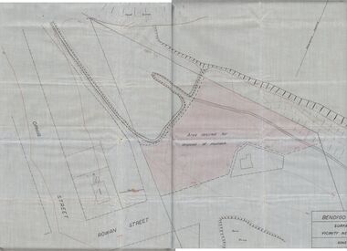
... and contour lines. Plan MCCOLL, RANKIN AND STANISTREET COLLECTION ...Pale blue waxed paper plan. Written on back of plan ' Monument Hill Battery site, area desired by Bendigo Mines (Nell Gwynne) for disposal of mullock. Plan shows Ophir Street, Rowan Street, Written on bottom RH corner 'Bendigo Mines Ltd., surface plan, vicinity Nell Gwynne Shaft, Scale 1" = 40' Magnetic north marked, sand dumps and contour lines.bendigo, business, mccoll, rankin & stanistreet -
 Bendigo Historical Society Inc.
Map - MINING PLAN ,VICTORIA HILL AREA, No date visible
Map: Large scale plan of an area of the Goldfield, Northward from Barnard Street, covering the Victoria Hill area. Black printing on polycarbonate film. Transparent.map, bendigo, mining plan, mining, gold mines, victoria hill, lines of reef -
 Bendigo Historical Society Inc.
Map - HUSTLER'S REEF & HUSTLER'S REEF NO 1 MINES - PLAN OF THE HUSTLER'S REEF & HUSTLER'S REEF NO 1 MINES
Plan of the Hustler's Reef & Hustler's Reef No 1 Mines on the Hustler's Line of Reefs, Bendigo Bulletin No 33, Plate No XIV. No 8 connecting No 10 (Hustler's Reef), No 11 connecting No 13 (Hustler's Reef), No 13 (Hustler's Reef No 1) connecting No 15 (Hustler's Reef) and No 10 Hustler's Reef No 1 rise to Comet Mine. Map shows different levels in relation to the two shafts, the lines of the Hustler's Line of Reefs and the Lightning Hill Line of Reefs, the approximate Boundary of Lease and the Comet Co., the adjoining lease. Table on the left shows the levels and their depths of the two mines. Signed by H A Whitelaw, Underground Survey Office, Bendigo, September 1913. Geological Survey of Victoria emblem. mining, parish map, hustler's reef & hustler's reef no 1 mines, hustler's line of reefs lightning hill line of reefs, comet co., h a whitelaw, underground survey office bendigo, geological survey of victoria -
 Bendigo Historical Society Inc.
Map - COMET MINE - LONGITUDINAL SECTION COMET MINE
Longitudinal section of the Comet Mine on the Hustler's Line of Reef Bulletin No 33, Plate No XXVI signed by H. S. Whitelaw, Underground Survey Office Bendigo, September 1913. Map shows datum lines, depths of levels, approximate boundaries and references to other plans. Note - Plates 4, 8, 13, 20, 26 and 31 form a Longitudinal Section from Fortuna Hustler's to Hustler's Consols Mine. Geological Survey of Victoriamining, parish map, hustler's line of reef, longitudinal section of comet mine bulletin no 33 plate no xxvi, h s whitelaw