Showing 5778 items
matching location
-
 Whitehorse Historical Society Inc.
Pamphlet, Schwerkolt Cottage Mitcham
A pamphlet issued by City of NunawadingA pamphlet issued by City of Nunawading on Schwerkolt Cottage with photographs and location map.A pamphlet issued by City of Nunawading schwerkolt cottage, city of nunawading -
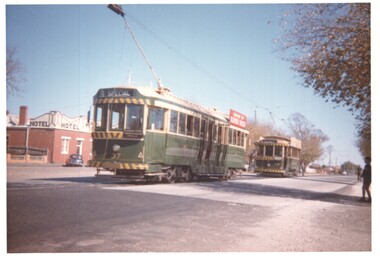 Ballarat Tramway Museum
Photograph - Set of 3 - AETA Tour Ballarat - trams 18 & 37, Ian Stanley, 21-4-1962
Photos show Ballarat trams 18 and 37 at three different locations during the tour of the Ballarat tram system by the Australian Electric Traction Association. Yields information about the 1962 AETA TourSet of three colour prints - Kodacolour of the AETA 1962 Easter Convention tour in Ballarat 21-4-1962 Has details of the location and dates on each print in pencil on rear.ballarat, tours, sturt st, specials, tram 37, aeta tours, tram 18, victoria st, sebastopol -
Whitehorse Historical Society Inc.
Pamphlet, Go Bush in Nunawading, c1986
Bushland parks in the city of Nunawading.Bushland parks in the city of Nunawading. A leaflet with names, location and native plant descriptions.Bushland parks in the city of Nunawading. city of nunawading. parks and recreation, parks and reserves, horticultural centre forest hill, schwerkolt cottage, native plants, campbells croft, abbey walk vermont, blackburn south recreation trail, blackburn creeklands, wandinong sanctuary, blackburn lake sanctuary, cootamundra walk, r. e. gray reserve, yarran dheran, antonio park mitcham -
Whitehorse Historical Society Inc.
Map, Aboriginal sites in the City of Doncaster-Templestowe, 1/03/1991 12:00:00 AM
Map of City of Doncaster and Templestowe.Map of City of Doncaster and Templestowe showing location of stone artefacts and scarred trees.Map of City of Doncaster and Templestowe. aborigines, city of doncaster and templestowe -
Whitehorse Historical Society Inc.
Document, McCubbin's Paintings, 1995
List of locally painted McCubbin's paintingsList of locally painted McCubbin's paintings with locations reported to Beryl Gray by Dorothy Meagher.List of locally painted McCubbin's paintingsmccubbin, frederick -
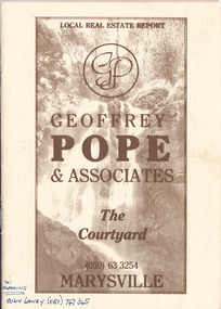 Marysville & District Historical Society
Ephemera (Item) - Property sales booklet, Geoffrey Pope, Local Real Estate Report-Geoffrey Pope & Associates, Unknown
A property sales booklet advertising properties for sale in Marysville and surrounding locations in Victoria.A property sales booklet advertising properties for sale in Marysville and surrounding locations in Victoria.re: CLEARING COLIN LAWRY (057) 747 345marysville, victoria, geoffrey pope & associates, geoffrey pope, real estate, the courtyard, real estate sales -
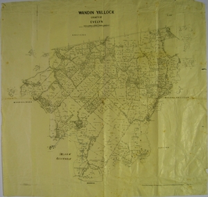 Yarra Ranges Regional Museum
Map, H J Green, Acting Govt. Printer, Wandin Yallock, County of Evelyn (Parish Plan), c. 1910 - 1920
Parish Plan of Wandin Yallock. Location of Silvan Reservoir marked in ink on map.Parish Plan of Wandin Yallock. Location of Silvan Reservoir marked in ink on map. wandin yallock, maps -
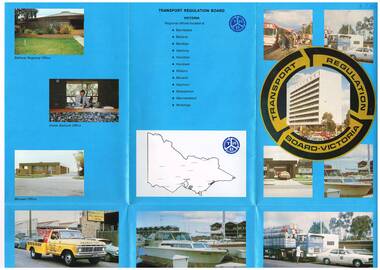 Melbourne Tram Museum
Pamphlet, Minister of Transport, "Transport Regulation Board Victoria", Mid to late 1970's
Pamphlet, folded sheet, six folds, full colour on blue background gloss paper titled "Transport Regulation Board Victoria" providing details of the origin of the Board, its function, facts about regulation, locations and many photographs of its activities and offices. No contact numbers or addresses. Printed in the same style as Reg Item 595.In ink in top left hand corner "4J40" - AETA Library location.trams, tramways, transport regulation board, trb, buses -
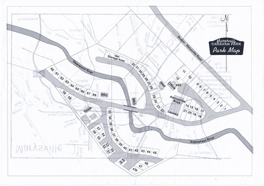 Marysville & District Historical Society
Map (Item) - Marysville Caravan Park map, Marysville CARAVAN PARK-Park Map, Unknown
A map of the Marysville Caravan Park showing the location of the various sites and facilities available to guests.A map of the Marysville Caravan Park showing the location of the various sites and facilities available to guests.marysville, victoria, australia, marysville caravan park, map -
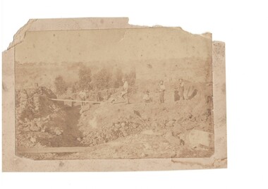 Buninyong & District Historical Society
Photograph - B/W photograph of shallow alluvial mine, Sepia mining scene
This photograph of miners at work on a shallow alluvial mine was taken around 1870 however the location, participants and precise date are unknownThis scene is typical of alluvial mining during the gold rush and up to the latter part of the 19th century showing gold miners and their equipment in actionSepia photograph of shallow mine with six miners location unknown c 1870Alluvial Mining late 19th centurygold mining, miners, tramway -
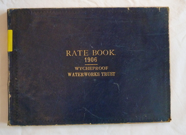 Wycheproof & District Historical Society Inc.
Register - Rate Book, Rate Book Wycheproof Waterworks Trust, 1906
This Register records names, locations, addresses of Ratepayers in the Rural area of Wycheproof in 1906.It is historically and socially significant at a State level as it is associated with the development of Wycheproof and District.Blue covered book with rectangular shape. Locations of Rateable Property encompasses a huge rural area. water-rates, rate-register, wycheproof - rural -
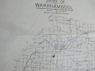 Peterborough History Group
Map - Shire of Warrnambool East Riding
Contextual location of Peterborough town within the shire at that time, including local roads.Historic informationA3 size map of the Warrnambool Shire East Riding, includes landscape details, and the location of town in the Shire.Irvine written in pencil on the backpeterborough, curdies river inlet, old maps, warrnambool shire map -
Whitehorse Historical Society Inc.
Pamphlet, Information Bulletin, 1/12/1993
Freeway Extension between Doncaster Road and Springvale Road to go ahead.Freeway Extension between Doncaster Road and Springvale Road to go ahead. Map showing location and history of project given.Freeway Extension between Doncaster Road and Springvale Road to go ahead. freeways, doncaster road, doncaster, springvale road, nunawading, vicroads, city of nunawading, city of camberwell, city of box hill, city of ringwood -
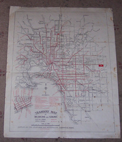 Ballarat Tramway Museum
Map, Melbourne and Metropolitan Tramways Board (MMTB), "Tramway Map of Melbourne and Suburbs", 1930c
Two colour map of Melbourne tramway Network, undated, but post the conversion of Collins St to electric trams (late 1929), c1930. Shows both electric and cable lines, various locations, eg the Motordrome, railway lines and primary streets. Compiled by the MMTB.On rear in pencil over three locations "Young Asst Mgr", "Young" and "L Calder? 6 Inglis? Wahroonga"trams, tramways, mmtb, map, cable trams, conversion -
St Vincent's Hospital Melbourne Archives
Photograph - Dorothy Stubbs photographs whilst nursing at St Vincent's Hospital Melbourne
Dorothy Stubbs and her nursing colleagues photographed at various locations at St Vincent's Hospital Melbourne. For example, "at Bottles", which was the nursing quarters separate from the hospital in Victoria Parade, and "St Micks" (St Michael's) ward in the Healy building.st vincent's hospital melbourne, nurse training, dorothy stubbs ( later morrison) -
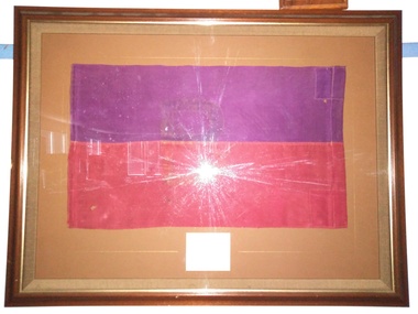 The 5th/6th Battalion Royal Victoria Regiment Historical Collection
Flag - Framed Textile, "B" Company 6th Battalion Flag, 1914
This flag was carried by B Coy and flown over the company HQ at all locations occupied by BCoy, including Gallipoli, Ypres and PozieresThis flag is connected to one of the two battalions that 5/6RVR derives its name.Flag in wooden frame on brown backing. The flag is a 6th Bn AIF colour patch( purple over red rectangles) with a large "B" barely visible after paint has been washed off . The flag itself is H 440mm x W 750mm A small card with "6 Battalion Royal Victoria Regiment" and RVR Badge printed on it and a hand written inscription is mounted below the flag.This flag was carried by B Coy and flown over the company HQ at all locations occupied by BCoy, including Gallipoli, Ypres and Pozieres.6bn, aif, ww1, colour patch, wark vc club, flag -
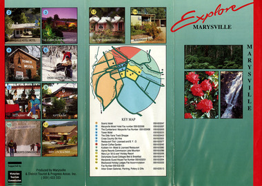 Marysville & District Historical Society
Ephemera (Item) - Information brochure, Marysville and District Tourist and Progress Association, Explore MARYSVILLE, Unknown
An information brochure with photographs and locations of various accommodation sites and businesses in Marysville as well as activities to experience in and around Marysville. This brochure was produced by the Marysville & District Tourist & Progress Association with the support of the Victorian Tourism Commission.An information brochure with photographs and locations of various accommodation sites and businesses in Marysville as well as activities to experience in and around Marysville.Supported by/ Victorian/ Tourism/ Commission Produced by Marysville/ & District Tourist & Progress Assoc. Inc.marysville, victoria, australia, information brochure, scenic motel, marysville motel hotel, the cumberland, tower motel, the olde yarra track shoppe, cross country ski hire, restaurant tirol, danish coffee garden, kufstein inn, lake mountain, mary-lyn resort, dalrymples guest cottages, marylands guest house, blackwood holiday lodges, abor green galleries, marysville & district tourist & progress association, victorian tourism commission -
Federation University Historical Collection
Flyer, QR codes used during the Covid 19 Pandemic
In the year 2020 there was a world wide pandemic of the Covid 19 Virus and QR codes were used to check into locations so outbreaks of the virus could be tracked to prevent further spread.A4 and A5 Sheets with QR codes used during the Covid 19 pandemic to chack into locations to keep track of outbreaks pandemic, covid 19, qr code, federation university -
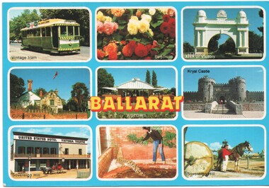 Ballarat Tramway Museum
Postcard - Ballarat 9 views - Rose Stereograph, Rose Stereograph Co, early 1980s
Postcard containing a 3 x 3 panel of 9 images of Ballarat Tourist locations - Ballarat Trams featuring tram 27 in the later SEC Colour scheme, Begonias, Arch of Victory, Curiosity Shop, Gardens hot house, Kryal Castle, Sovereign Hill and the Reptile Park. Produced by Rose Stereograph Co. of Glen Waverly, No. 1679. Tram 27 was repainted in an early SEC Colours during 1984.Yields information about Ballarat tourist attractions during the early 1980s.Postcard - plain edges, divided back, 9 images of Ballarat Tourist locations.ballarat, trams, tramcars, btps, tourism, tram 27, gardens -
Whitehorse Historical Society Inc.
Map, Mitcham, 1880s?
Hand drawn map of area north and south of Whitehorse Road and South of Canterbury Road c.1880-1900.Hand drawn map of area north and south of Whitehorse Road and South of Canterbury Road c.1880-1900. Probably sketched by a McClare descendant. Includes locations and names of settlers of that time.Hand drawn map of area north and south of Whitehorse Road and South of Canterbury Road c.1880-1900. whitehorse road, mitcham, mitcham road, mitcham, l l vale road, vermont, canterbury road, mitcham -
 Whitehorse Historical Society Inc.
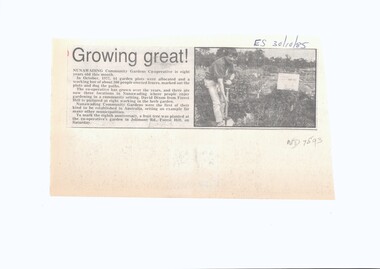
Article, Growing Great, 1985
Nunawading Community Gardens Co-operative was formed in 1977.Nunawading Community Gardens Co-operative was formed in 1977, the first of its kind in Australia. There are now three locations in Nunawading where people enjoy gardening in a community setting.Nunawading Community Gardens Co-operative was formed in 1977. nunawading community gardens, unique -
Whitehorse Historical Society Inc.
Article, Bureau On The Move, 1993
The Youth Adult Bureau will move to Silver Grove, Nunawading.The Youth Adult Bureau will move to Silver Grove, Nunawading. which is a more central location in the municipality. Nunawading Council allocated a Budget of $50,000 for the development of a permanent site for the Bureau.The Youth Adult Bureau will move to Silver Grove, Nunawading. youth services, the youth adult bureau, silver grove, nunawading, city of nunawading -
 Bendigo Military Museum
Photograph - PHOTOGRAPHIC COLLAGE, c.1954
Various photos of Australian soldiers in the mid 1950's at training on tourist locations in Central Victoria and Puckapunyal.Series of 7 small black and white photos stuck on an A4. piece of paper, showing various Australian soldiers at various locations in Central Victoria with typed captions underneath each.Each photo has an identifying caption.photographic collage, training, army, puckapunyal -
 Federation University Historical Collection
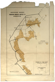
Plan, Underground Workings, Working Miners United Co. Homebush
Printed map on paper various measurements and locationsunderground workings, plan, working miners united co, homebush -
 Melbourne Tram Museum
Photograph - Set of two colour prints of L class 102 on a tram tour, Bill Kingsley, July 1974
Set of two photographs, possibly during a Footscray Technical College tour in July 1974. Such tours were arranged by Bill Kingsley. 1 - L 102 at Brunswick Depot. Note the destination of "Fawkner" - which was used to link with bus services at various times of the day between North Coburg and Fawkner station - see reference. 2 - ditto turning from Pilkington St into Barkly St North Fitzroy, part of the single track Holden St. line.Yields information about the use of L class trams.Set of two colour prints, Kodak paper with date of July 1974 on rear.Location and tour notestrams, tramways, l class, tram 102, pilkington st, barkly street, bill kingsley., brunswick depot -
Ringwood and District Historical Society
Letters, Heatherdale Pre-School Association: First year of operation 1953. Documents, 1953
Heatherdale Pre-School Association. First year of operation 1953. Location Yallourn Parade, Ringwood.Documents from Heatherdale Pre-School Association. First year of operation 1953. Location Yallourn Parade, Ringwood. File No. 3, Financial Statements. Grant Letters. Department of Health Letters.File and Letters -
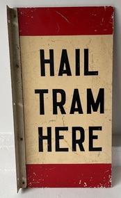 Melbourne Tram Museum
Sign - Tram Stop - "Hail Tram Here"
Indicated or provided a location to tram drivers and passengers of a tram stop that trams had to be hailed or signaled to stop or to alight. Demonstrates the form of tram stop that the MMTB used in Melbourne that trams had to be signaled to stop at. An early style before the use of enameled signs. Sign - Tram Stop - "Hail Tram Here" - formed from a painted type of fibre board with an aluminium angle and flat riveted in four locations with three screw holes on the side.tram stop, signs, mmtb, tramways, trams -
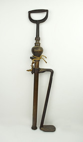 National Wool Museum
Pump
Foot/hand pump consists of a pedal and hose.Wording: SUCCESS;Method: Embossed;Location: Pedal Wording: SUCCESS SALEM OHIO;Location: Handle Wording: SUCCESS DEMING COMPANY;Location: Handle -
 Mission to Seafarers Victoria
Photograph - Photograph, Sepia, Picnic at Cattarno, 26 December 1913
The property Cattarno, Caulfield, where the Misses Slaney resided was the location for a Boxing Day picnic in 1913. The location was also used for a drawing room for the purposes of fundraising and is mentioned in the Michaelmas issue of the LHLG newsletter "Jottings from our Log" 1913, Michaelmas issue.Depicts one of the key host venues for both Drawing room events and venues for picnics and visits with seafarers.Small monochrome photograph (faded) depicting outdoor gathering of seamen and LHLG members.Printing instructions are handwritten at the back in pencil: Top right corner: "This block not sent" with dimensions and "print". also in pencil: snapshot at / Picnic at Catarno [sic the spelling of the location is wrong here] Blue stamp: "520"lhlg, picnic, cattarno, boxing day, caulfield, glen eira, miss slaney, henry slaney, margaret harriott hart -
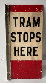 Melbourne Tram Museum
Sign - Tram Stop - "Tram Stops Here"
Indicated or provided a location to tram drivers of a tram stop that all trams had to stop at - a compulsory stop. Style Used from early 1920's.Demonstrates the form of compulsory stop that the MMTB used in Melbourne. An early style before the use of enameled signs. Sign - Tram Stop - "Tram Stops Here" - formed from a painted type of fibre board with an aluminium angle and flat riveted in four locations with three screw holes on the side.tram stop, signs, mmtb, trams, tramways