Showing 1660 items
matching maps and documents
-
 Melbourne Tram Museum
Document, Engage Victoria, Footscray and Maribyrnong Tram Corridor Planning _ Engage Victoria, July 2024
Digital document from Engage Victoria looking at options and feedback for possible changes to the Route 82 route in Maribyrnong and Footscray areas for the introduction of low platform stops in Gorden St and Droop St. Includes a map for proposed stops and existing stops. The document notes that funding for stop upgrades is part of a future budget process.Demonstrates a Consultative document by Engage Vic. August 2024.Digital document - 11 pagestramways, platform stops, footscray, maribyrnong, route 82, consultation -
Melbourne Tram Museum
Document, Engage Victoria, Route 86 Tram Corridor Planning _ Engage Victoria, April 2024
Digital document from Engage Victoria looking at options and feedback for possible changes to the Route 86 route in Fitzroy and Northcote areas for the introduction of low platform stops in Gertrude, High and Smith Sts. Includes a map for proposed stops and existing stops. The document notes that funding for stop upgrades is part of a future budget process.Demonstrates a Consultative document by Engage Vic. April 2024.Digital document - 10 pagestramways, platform stops, consultation, route 86, fitzroy, northcote, smith st, gertrude st, high st -
 Bendigo Historical Society Inc.
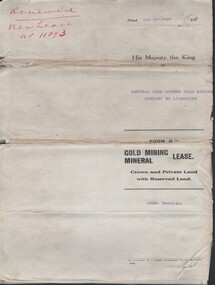
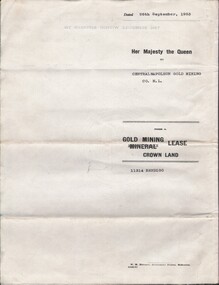
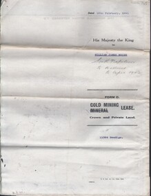
Document - MCCOLL, RANKIN AND STANISTREET COLLECTION: CENTRAL NELL GWYNNE - FORM D GOLD MINING LEASE 10981 BENDIGO, 5 Oct 1936
Document. Renewal New Lease no 11073 His Majesty the King to Central Nell Gwynne GMC N/L. 1 map no 10981 of Mining District of Bendigo Parish of Sandhurst City of Bendigo County of Bendigo. No 10981 Bendigo Vo 322 Fol 35594.McColl, Rankin & Stanistreetorganization, business, central nell gwynne, mccoll, rankin & stanistreet, cnetral nell gwynne, gold mining, lease -
 Bendigo Historical Society Inc.
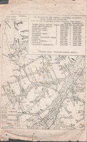
Document - MINING REPORTS - MAP OF PART OF THE BENDIGO GOLDFIELD INCLUDING WHITE HILLS AND EAGLEHAWK
BHS CollectionMap of part of the Bendigo Goldfield including White Hills and Eaglehawk. Map shows reef lines, gullies, railway line, tram route, type of rock, name of mine, Calls and Dividends. Also Deepest Mine Victoria Quartz 4614 ft. Names of Mines are Garden Gully United, Great Ext'd Hustlers, Johnson's Reef, South New Moon, New Moon, Catherine Reef, Virginia, Central Red White & Blue, Ironbark, Kock's Pioneer, Carlisle and the Hercules & Energetic. Map is part of the Albert Richardson Collection of mining documents and research. document, gold, mining reports, mining reports, map of part of the bendigo goldfield including white hills and eaglehawk, pabst bendigo goldfield, garden gully united, great ext'd hustlers, johnson's reef, south new moon, new moon, catherine reef, virginia, central red white & blue, ironbark, kock's pioneer, carlisle, hercules & energetic. victoria quartz -
 Bendigo Historical Society Inc.
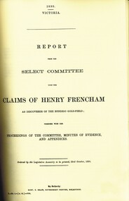
Book - 1890 ROYAL COMMISSION GOLD DISCOVERY BENDIGO, 1890
( x ref 5673 , 8235 , Box 83 , 9077 ) Photocopy of original documents from the 1890 Royal Commission into who discovered the first gold in Bendigo with a report from the Select Committee upon the claims of Henry Frencham and evidence from other claimants plus a map.bendigo, history, early digging days, bendigo- history- gold- pioneers -
Melbourne Tram Museum
Document - La Trobe St, Public Transport Victoria (PTV), "Tram stop upgrades, relocations and removals", July 2024
Digital document from Public Transport Victoria (PTV) about the installation of platform stops in La Trobe St including the removal of existing stops. Has a map and images of the works that were undertaken during July and August 2024.Demonstrates a PTV information document regarding the installation of Platform stops in La Trobe St.Digital document - 5 pagestramways, platform stops, consultation, la trobe st, tram tracks -
 Warrnambool and District Historical Society Inc.
Documents, Late 20th, early 21st centuries
... Documents ...These ten documents (maps, plans, photographs) mostly come from the Warrnambool City Council and most contain information on sub-divisions and titles of properties in areas around the Central Business District of Warrnambool. The dates range from 1986 to 2006. These maps, plans and photographs are of some interest as they give historical details of subdivisions in Warrnambool and date from the late 20th century. .1 This is a laminated map of the boundaries of Local Governments in Victoria. It is Sheet I of 2 and has red and blue pencil markings and black boundary markings. .2 This is a copy of a plan of a survey in black and white markings on paper. .3 This is a plan of the title details of Section 19 Warrnambool. It has black printing on buff-coloured paper. .4 This is a plan of the allotments in part of the Central Business District of Warrnambool. It is printed in black and white. .5 This is a 2006 coloured aerial photograph of the harbour at Warrnambool – Breakwater etc. .6 This is a 2006 coloured aerial photograph of the Lake Pertobe area in Warrnambool .7 This is a coloured aerial photograph of Warrnambool’s streets over-stamped with road numbers in large blockings. .8 This is a plan showing the title details of Section 11 in Warrnambool. It has black printing on buff-coloured paper. .9.1 This is a plan of sub-divisions in parts of Crown Allotments 38 & 39 in Warrnambool. It has green, pink and yellow markings with black printing. .9.2 This is a plan of the sub-divisions in parts of Allotments 38 & 39 in Warrnambool. It has pink, yellow and blue markings with black printing. It is somewhat faded. warrnambool c.b.d. maps and plans, history of warrnambool -
 Bendigo Historical Society Inc.
Document - GOLDEN GULLY ALLUVIAL WORKINGS
Golden Gully alluvial workings, Diamond Hill area, site number 1.1. Document has map/grid references, parcel number and location - runs along Woodward Road. History from 1851 to 186 detailed. . Information from David Bannear's Bendigo goldfields survey. -
 Bendigo Historical Society Inc.
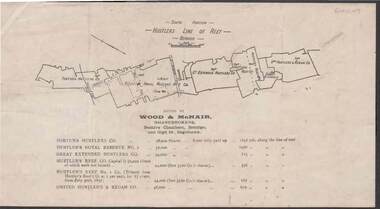
Document - KELLY AND ALLSOP COLLECTION: HUSTLERS LINE OF REEF MAP, 30/07/1891
Document. KELLY & ALLSOP COLLECTION. Map of the Hustlers Line of Reef, Bendigo (South portion). Issued by Wood & McNair, Sharebrokers, Beehive Chambers, Bendigo and High St., Eaglehawk. Mines shown on map are Fortuna Hustler's Co., Hustler's Royal Reserve No.2, Great Extended Hustlers Co., Hustlers Reef Co., Hustler's Reef No.1 Co., United Hustler's & Redan Co. Number of shares is listed against each of these mines.Wood & McNairbusiness, stockbroker, kelly & allsop, kelly & allsop collection, hustlers line of reef map, wood & mcnair. -
 Bendigo Military Museum
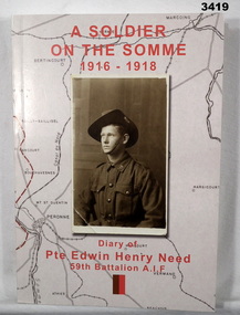
Book - BOOK WW1, Joan Scott, A Soldier of the Somme 1916 - 1918, 2014
Book, soft cover, cardboard, red print on front, spine & back. Sepia background map with half portrait sepia photo of soldier in uniform on front. 186 pages, cut plain, off white. Illustrated black & white photos, documents. End papers illustrated with diary notes.Title page: "Diary of Pte Edwin Henry Need, 59 Battalion AIF" Handwritten in black ink on title page: "Donated by Joan Scott" "Bendigo RSL stamp in black ink"book, somme, somme ww1 -
 Bendigo Historical Society Inc.
Document - MCCOLL, RANKIN AND STANISTREET COLLECTION: THANET LEASE, 1930's
Manilla folder of documents relating to the application by Herbert Jackson Leed for mining lease No. 10500, called the Thanet Lease. Containing a list of all of the owners of the allotments on the proposed lease and consent forms for them to sign. A map of the lease and of the subdivision of allotments 97 and 92. Various correspondence and application forms.gold, mining, land application, bendigo, gold mining. thanet lease, herbert jackson leed. -
 Ballarat Tramway Museum
Document - Re typed article, "Cable and rope traction", c1950
Three page typed copy of an article appeared in Engineering 1887 on Melbourne cable tramways construction. Carbon copy of typing on both sides of 1 sheet and 1 sheet of pink paper with hand drawn copy of a map in 4 colours. Image of document added 25/8/2013.trams, tramways, melbourne, cable trams, construction -
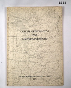 Bendigo Military Museum
Administrative record - Royal Australian Survey Corps - Colour Orthophotos for Limited Operations 1971, Army Survey Regiment, Bendigo, 1971
This is a report on the experimental production of the colour Orthophoto Map 1:25,000 7924 - 3 - SW Northwood (Puckapunyal area) during 1971 conducted at the Army Survey Regiment Bendigo. The report covers all aspects of production including cartographic enhancement, test proofing, platemaking and printing. While Annexes A and C are listed in the contents, they are missing from the document. A second copy has been added to this record that contains Annex A that is a colour enhanced colour orthohotomap of the map sheet.Soft covered A4 sized booklet stapled along the left hand side. Title and a greyed map image printed on cover. A second copy containing Annex A was added in 2025royal australian survey corps, rasvy, fortuna, army survey regiment, army svy regt, asr -
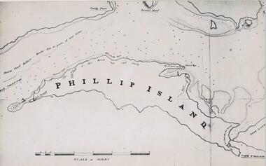 Phillip Island and District Historical Society Inc.
Photograph, Bryant West
... documents ...One of a collection of over 400 photographs in an album commenced in 1960 and presented to the Phillip Island & Westernport Historical Society by the Shire of Phillip IslandPhotograph of a Map of Phillip Island. The first to show Fort Dumaresq, track to beach and beginning of road to South coast. local history, photography, photographs, exploration, maritime, documents, maps, phillip island, john jenner, bryant west -
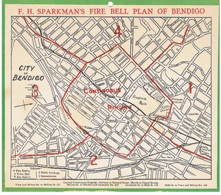 Bendigo Historical Society Inc.
Document - FIRE BELL PLAN OF BENDIGO
Plan Document. A Fire Bell Plan of Bendigo issued by F.H.Sparkman. A street map of Bendigo split up into a central zone plus four surrounding zones. It is probably the upper part of a calendar with the date section missing (torn off). F.H.Sparkman was a printer and a Mason. Date not shown but probably prior to 1950F.H.Sparkmanessential services, firefighting, fire bell plan of bendigo, fire bell plan, f.h.sparkman -
 Federation University Historical Collection
Document, Ken Clements, Peterborough Puzzles, 2009, 2009
... maps ...Massacre Bay is located on Victoria's Great Ocean Road, and is in the centre of the Bay of Martyrs. The bay consists of 20 m high, red limestone bluffs. This paper by Ken Clements considers the origin of the term martyr in connection to this location, and where the Aboriginal massacre may have taken place. Thirteen page document by Ken Clements relating to Peterborough, Victoria. Contents include coastal features, local Aborigines, Bay of Martyrs, Massacre Bay, Massacre Hill, Buckley Creek Run, Pioneer Pastoralists, British Traversers, settlers, Peterborough, Maps, tourism, history method. Photographs by Laurie Moore.aborigines, bay of martyrs, massacre bay, massacre hill, buckley creek run, pioneer pastoralists, british traversers, settlers, peterborough, maps, tourism, history method, childers cove, barque children, murnane bay, sandy bay, dog trap bay, buckley creek, viviennes lookeout, stanhope bay, buttres bay, burnies beach, armstrong creek, flaxman hill, antares rock, lovers nook, crofts bay, clements, worm bay, halladale point, the well, wold dog cove, james irvine monument, curdies inlet, squirrel creek, wallaby creek, boggy creek, whiskey creek, pioneer beach, schomberg rock, young australia, spit, crown of thorns, newfield bay, the grotto, london bridge, point hesse, high cliffs, the arch, cape martyr, little massacre bay, aboriginal massacre, ken clements -
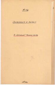 Melbourne Tram Museum
Legal record, Commonwealth of Australia - Copyright Office, "Commonwealth of Australia - Re copyright Tramway Routes", 8/12/1925 12:00:00 AM
... Maps ...Legal document within a light brown manila document - titled "Commonwealth of Australia - Re copyright Tramway Routes". Typed on pre-printed paper, Copyright Office, No. 14428, registering the MMTB as the copyright owner in a literary work, a map, entitled "Melbourne's Tramway Routes and Time Tables". Dated 8-12-1925, with date stamp of 22/12/1925 as being received by the Board. Address to A. S. Whyte of the Board. Folder has file number "110" written on the outside.trams, tramways, mmtb, commonwealth government, legal agreements, copyright, maps -
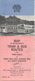 Ballarat Tramway Museum
Map, Survey and Mapping for MMTB, "Map of Melbourne's Trams and Bus routes and all night services", Jan. 1967
Fold out sheet coloured map, 12 portions or folds, - title - "Map of Melbourne's Trams and Bus routes and all night services" map shows trams lines, route numbers, terminal points, bus routes, railway lines, blow up of city area with places of interest and key. On rear details, places of interest, suburb index, index to routes, first and last services, Sunday am services, all night bus services and locations of depots and head office. 2nd copy added 11-8-2006. Images of document - scanned to A3 size and overlapping added 30/10/13 On rear "out of date" stamp and 1 "cancelled" stamp - red ink.trams, tramways, melbourne, map, tram & bus services, all night services -
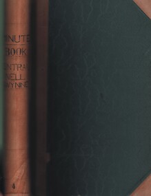 Bendigo Historical Society Inc.
Document - MCCOLL, RANKIN AND STANISTREET COLLECTION: CENTRAL NELL GWYNNE GMC N L - MINUTE BOOK, 1946 - 1955
Document. Leather bound (tan) green cardboard cover. Hand written minute book. Dated 20/12/1946 - 24/6/1955. 2 hand drawn maps of mine on drafting paper. Letters re sale of buildings, battery & equipment for cost of 7500 pound. Complete description of battery.McColl, Rankin & Stanistreetorganization, business, central nell gwynne, mccoll, rankin & stanistreet, central nell gwynne gmc n l, gold mining, minute book -
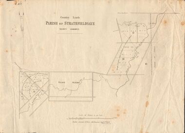 Bendigo Historical Society Inc.
Document - MARKS COLLECTION: MAP OF PARISH OF STRATHFIELDSAYE 1858, 8th September, 1858
Buff coloured document. On top 'Country Lands, Parish of Strathfieldsaye, County Unnamed'. On bottom 'Scale 40 chains to an inch. Public Lands Office, Melbourne Sept 8th. 1858. William Collis, Lith ( lithographer )'. Map shows Village Reserve on Emu Creek, road from Sandhurst, Sheepwash Creek and Splitters Creek. Wellington Hotel marked on map near intersection of Sheepwash Creek, Axe Creek and Emu Creek. Axe Creek Pound near Splitters Creek.map, bendigo, parish of strathfieldsaye 1858 -
 Melbourne Tram Museum
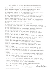
Document - Report, Melbourne & Metropolitan Tramways Board (MMTB), "Melbourne and Metropolitan Tramways Board General Scheme", c1923
Personal Papers titled "Melbourne and Metropolitan Tramways Board General Scheme": File comprises of: 1. Typed document noting the MMTB Minute of the Board meetings of 30/11/1922, 24/5/1923 and 26/7/1923 approving the General Scheme be forwarded to the Minister and the Parliamentary Standing Committee and changes to resolve crossing the Railway at Brighton Station. 2 - Printed document - 1923 - Report - 8 pages - The Parliamentary Standing Committee on Railways - General Scheme for Tramways for Metropolis - printed 24/7/1923. Has stapled to the document a pink cover sheet. Gives details of the committee, the committee report, comments on the Board's financial position, the debate between tramways or railways, recommendations and views of the Railways Commissioners. Attached to the report is the MMTB 30 page duplicated document giving the Board's proposals. See Reg Item 2089 for actual drawings referred to. See Reg Item 2098 and 3374 for another copy of this document and the map.Both documents have been stamped "Perway File"trams, tramways, mmtb, general scheme, tramways, development, parliament, brighton, railways, finances -
 Bendigo Historical Society Inc.
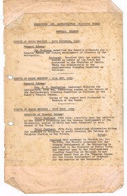
Document - MCCOLL, RANKIN AND STANISTREET COLLECTION: CENTRAL NAPOLEON GOLD MINING CO. N.L, 22nd June 1954
Document :Form A, Gold Mining Lease Crown Land 11314 Bendigo, Entered in the Register Book, Vol. 333 Fol. 138, Embossed seals of Central Napoleon and King George VI, Map: Mining District of Bendigo County of Bendigo Parish of Sandhurst, During the reign of Queen Elizabeth II, 4 pages.organization, business, industry - mining, mccoll rankin & stanistreet, mining, gold mining, central napoleon -
 Bendigo Military Museum
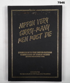
Book - POW SUBMISSION, Queensland Ex-POW Reparation Committee, "NIPPON VERY SORRY - MANY MEN MUST DIE", 1990
Refer Cat. No. 7944. Item in the collection of "Arthur E. Tranter" V50166 - VX52843 2/29th Bn. P.O.W. From front cover "NIPPON VERY/ SORRY - MANY/ MEN MUST DIE" "SUBMISSION TO THE UNITED NATIONS/ COMISSION OF HUMAN RIGHTS/ (ECOSOC RESOLUTION 1503)". "AUTHORISED BY / THE QUEENSLAND EX- POW REPARATION COMMITTEE".hard cover book. Cover - cardboard with black colour buckram adhered cover with gold colour print front and spine. 123 pages - cut, plain, off white colour paper. Illustrated black and white phtographs, documents and maps. End papers - front and back - illustrated with a diagram of the "BURMA- SIAM RLY".publications, book, military history, ww2, tranter, pow's -
 Bendigo Historical Society Inc.
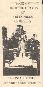
Document - BENDIGO CEMETERIES COLLECTION: SELF GUIDED TOUR HISTORIC GRAVES WHITE HILLS CEMETERY DOCUMENT
BHS CollectionLemon coloured trifold document : Tour of Historic Graves at White Hills Cemetery. Friends of the Bendigo Cemeteries. Map of White Hills Cemetery (1854 - 1993 ) showing marked grave sites with descriptions. E.g. Charles Merri Bux - 'Black Charlie' Indian hawker of Bendigo. History of White Cemetery on back page.Friends of Bendigo Cemeteriesbendigo, cemetery, white hills cemetery -
 Eltham District Historical Society Inc
Document - Folder, Bridgeland Estate, Eltham South, 1998
Various documents, including a history, letter and reminscences relating to properties of the Bridgeland Estate including Antoinette Boulevard and Leonard Crescent, Eltham South. 5 photocopies of parts of maps relating to subdivisions from 1842 to the 1925 Bridgland Park Estate Folders 78 and 80 from Harry Gilham Collection 12 pagesantoinette boulevard, leonard crescent, eltham south, bridgeland park estate, harry gilham collection -
 Melbourne Tram Museum
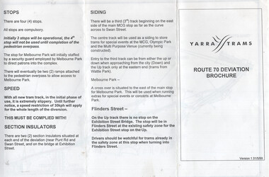
Document, Yarra Trams, "Route 70 Deviation Brochure", 5/1999
Document issued to crews at the time of the opening of the Batman Ave Deviation in June 1999. Pamphlet dated 31/5/1999. Wikipedia Reference for the route dates the use from 6/6/1999. Has a map, notes on the tram stop, speed, section insulators and the siding. Published by Yarra Trams.Demonstrates a Yarra Trams pamphlet at the time of the relocation of route 70 from the Batman Ave terminus to its operation via Flinders St and the Exhibition St bridge.Document - or pamphlet - titled "Route 70 Deviation Brochure" - A4 sheet, 3 fold DL.tramways, route 70, yarra trams, new tramways, batman ave, new track -
 Bendigo Historical Society Inc.
Document - MCCOLL, RANKIN AND STANISTREET COLLECTION: NAPOLEON REEF GOLD MINING CO. N.L, 18 Feb 1941
Document: 4 Page legal document with map of lease area issued to William James Moore of Bendigo, Lease No. 11064 Bendigo, Vol. 325 Fol. 35881 County of Bendigo Parish of Sandhurst, 15 year lease from 18th February 1941, in vacinity of Curnow St, Booth St, Maple St and Rowan Sts, Lease by South Napoleon to be allowed to lapse in 1942, signed by Major General Sir Winston Joseph Dugan Governor of Victoria, William James Moore & witnessed by Walsh, Wardens Clerk Bendigo.organization, business, industrial - mining, mccoll rankin & stanistreet, mining, gold mining, napoleon reef -
 Melbourne Tram Museum
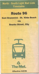
Document - Timetable - Route 96 - East Brunswick - St Kilda Beach, The Met, 2/1991
Timetable dated 6-2-1991 provides information on the East Brunswick to St Kilda Beach via Bourke Street services, including a map, route description, time points, fare secrtions and contact details. Published by The Met. Has the words "North-South Light Rail Link" on the top of the document. Yields information about Route 96 tram services on the St Kilda light rail line.Document - 10 fold sheet - Timetable - Route 96 - East Brunswick - St Kilda Beachtramways, timetable, route 96, east brunswick, st kilda beach, light rail, the met -
 Phillip Island and District Historical Society Inc.
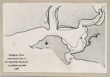
Photograph, Bryant West, 1798
... documents ...One of a collection of over 400 photographs in an album commenced in 1960 and presented to the Phillip Island & Westernport Historical Society by the Shire of Phillip IslandPhotograph of the First Map of Phillip Island ever drawn. An eye sketch by Bass.As written on front of map - "Western Port on the South Coast of Nw. South Wales from GE Bass's Eye-sketch 1798"local history, photography, photographs, exploration, maritime, documents, maps, george bass, phillip island, bryant west, john jenner -
 Bendigo Military Museum
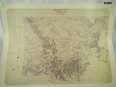
Map - Australian Topographical Survey SYDNEY / 56III Southern Half, NE Plane Table Field sheet 1915, Australian Survey Corps, 6 Dec 1915
This is a unique example of a hand drawn plane table sheet produced in the first year of the Australian Survey Corps by original members of the Corps. Roseblade and Lynch 5 Dec 1915. Of interest is the documented times that it took to create the original field sheet. Also of interest is the fact that this field sheet that was used to create the actual SYDNEY map sheet was contoured, many map sheets produced up until now were purely planimetric and lacked contouring that was needed for military use. This is a reproduction print of a photograph of the original field sheet and was printed at the Army Survey Regiment, Bendigo.Reprinted coloured Image of Australian Topographical Survey SYDNEY /56 III Southern Half, hand drawn NE Plane Table field sheet. Includes an itemized summary of work performed by HA Roseblade CSM Australian Survey Corps 1915, Signed by J Lynch Lieutenant.royal australian survey corps, rasvy, fortuna, army survey regiment, army svy regt, asr