Showing 2395 items
matching maps of goldfields
-
 Bendigo Military Museum
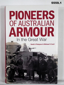
Book - BOOK, LEAFLET & LETTER, David A FINLAYSON & Michael K CECIL, "Pioneers of Australian Armour in the Great War", 2015
Part of the Leo Reoch Cohn Collection. See Catalogue No. 5527.2 for his service record.Hard Cover Book with Dust Cover. 1. Hard cover - cardboard, black colour buckram, gold print on spine. Dust cover - paper, red, white and black print on front, spine and back. Illustrated black and white photographs, front armoured car with crew. Back - tank with 3 persons. 376 pages, paper, cut, plain, white. Illustrated black and white photographs and maps. 2. Leaflet - for book launch, thick paper, white, red and black print with two illustration as per dust cover. 3. Letter - paper, white with black print from book authors, 1. Front end paper, handwritten blue ink "David Finlayson/ 15 Aug 15".books, armoured vehicles, tanks, ww1, ww2 -
 Bendigo Military Museum
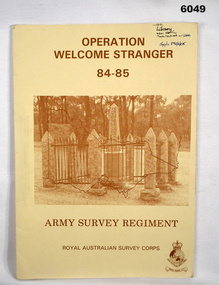
Administrative record - Army Survey Regiment - Operation Welcome Stranger - Operation Report
Operation Report of Mapping areas in central Victoria in 29 Mar 84 - 6 Mar 85. Covering 1:250,000 map areas SJ54-4 St Arnaud, SJ 55-1 Bendigo, SJ54-8 Ballarat, SJ %%-2 WangarattaAn A4 booklet sepia cardboard cover, brown text Survey Corps Badge, Photo of " Welcome Stranger Monument", outline shape of Victoria, glide on Arnos fastener binder.royal australian survey corps, rasvy, fortuna, army survey regiment, army svy regt, asr -
 Bendigo Military Museum
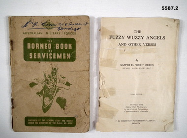
Booklet - BOOKLETS WW2, 2) Sapper H "Bert" Beros NX6925, Fuzzy Wuzzy Angels, The Borneo Book, 1) c.1940's. .2) c.1942
items in the collection re George Lunn VX76842 2/9 Fld Coy, refer Cat No 5581 for his service history..1) The Borneo book for servicemen, card cover 58 pages, maps, photos, contents are in 10 sections re aspects of life/service in Borneo. At rear is 4 pages of hand written notes possibly by a child. .2) Bok Fuzzy Wuzzy Angels and other verses, no covers, 102 pages, contains photos, stories and poetry, held together by 3 staples.booklets, borneo, fuzzy wuzzy -
 Bendigo Military Museum
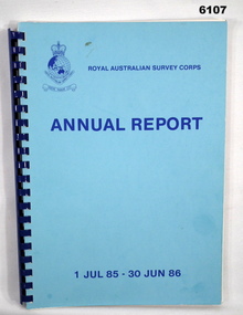
Administrative record - Royal Australian Survey Corps Annual Report 1 Jul 85 - 30 Jun 86, DSvy - A, RASvy Corps, Report on activities 1 Jul 85 - 30 Jun 86, Circa 1986
The status of RASVY activities (for the dates shown) in field surveying, mapping and charting is given in this report and is shown pictorially in the Annexes to the reportBlue book, plastic ring binder, Map and Chart production 85-86, Annexes graphically depicting map productionroyal australian survey corps, rasvy, fortuna, army survey regiment, army svy regt, asr -
 Bendigo Military Museum
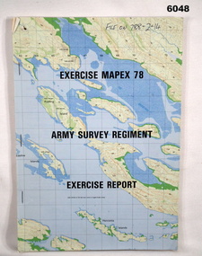
Administrative record - Army Survey Regiment - Exercise Mapex 78, Mar 1979
Exercise Report on exercise Mapex 78. The exercise was designed to test the Army Survey Regiment in an intensive production phase of 30 days duration.A4 soft covered booklet, printed map of part of the Kimberley region of Western Australia on front and back covers, staple boundTop right hand corner of front cover "File on 788-2-14"royal australian survey corps, rasvy, fortuna, army survey regiment, army svy regt, asr -
 Bendigo Military Museum
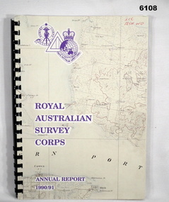
Administrative record - Royal Australian Survey Corps - Annual Report 1990/91, Royal Australian Survey Corps, Late 1991
Annual Report detailing the status of Australian mapping, charting and geodesy for the period 1 Jul 90 - 30 Jun 91A4 soft covered book, glossy paper pages and plastic pockets containing maps. Plastic ring bindingTop right hand corner "2IC Tech WO"royal australian survey corps, rasvy, fortuna, army survey regiment, army svy regt, asr -
 Bendigo Military Museum
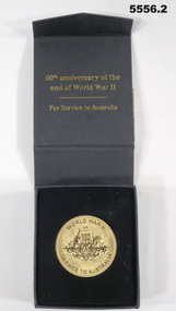
memorabilia - MEDALLION, 60th ANNIVERSARY, Australian Government, 2005
Items refer to the service of VX79511, "John Alexander McDonald" Refer to Cat 2481.2 for service details.1. Gold coloured metal disc. one side has the crest of Commonwealth of Australia, other side has a stylised map of Australia and Tasmania with the number 60 over it. 2. Black cardboard presentation box.ww2, 60th anniversary medal -
 Bendigo Military Museum
photograph - Cartographic Squadron Production – Army Survey Regiment, Fortuna, c1980
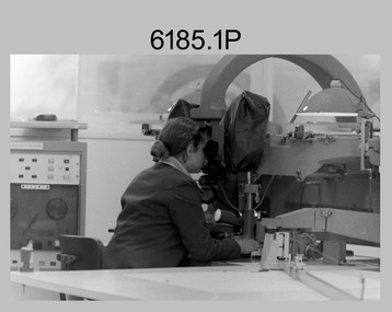
This collection of 12 photos was most likely taken in 1980. The photos were most likely taken in Cartographic Squadron’s Ante Room, the Attic and small offices on the top floor of Fortuna Villa. The computer based Editwriter typesetting system was introduced in 1975 as a replacement to the aging Fotosetter machine. It was operated by a specialised technician, who generated a large variety of map type styles and sizes quickly and reliably, as well as text panels. CPL Richards performed this task for several years and in photo .1P and .2P is reading off a type order next to the computer monitor. Output on Copy proof adhesive backed stripping type film replaced messy wax and spray adhesives in 1978. The Editwriter capability supported all RASvy units and contractor type setting requirements. Scribing was the cartographic process of drafting features such as drainage, relief, vegetation, roads and culture on specially coated map reproduction material. The cartographic technician scribed out the map feature such as a contour to a specified line width on the map sheet, using a tool affixed with a sapphire tipped cutter. The quality control edit (Proving) stage of map production was the first opportunity to inspect a proof of the map independently and systematically. Proving tasks were carried out by technicians conversant of the map product specification and task requirement, however, was not involved in its production. Corrections were identified, marked up and sent to back to the correcting section or contractors. Terrain Embossing was a manual map production technique to produce hill shading on medium to small scale graphics and air charts. SPR John Martin is seen in photos .8P to.10P using a fine embossing metal stylus to push down on the drainage impression on a thin malleable opaque plastic material (AK Poligraphy). Ridge lines were then pushed down using the contour impression as a guide, on the opposing side of the AK Poligraphy to create a 3D plastic model terrain effect. The map impression was sprayed with white paint and photographed to create a contone tone hill shade. SPR Gina (Coore) Neilson is seen in photo .11P washing a contone positive of a land mass in a solution. The contone components were registered to the map sheet, as shown in photo .12P and masked using an air brush and a halftone negative was then created. The terrain embossing method of producing hill shading was more efficient to produce than previous specialised artistic methods such pencil/eraser and air brush. Furthermore, a more consistent enhancement of terrain on charts was achieved between technicians.This is a set of 12 photographs of Cartographic Squadron performing four map production tasks at the Army Survey Regiment, Fortuna, Bendigo c1980. The first ten photographs were on 35mm negative film and were scanned at 96 dpi. Photos .11P and .12P were on photographic paper and scanned at 300 dpi. They are part of the Army Survey Regiment’s Collection. .1) - Photo, black & white, c1980, Editwriter typesetter, CPL Paul Richards. .2) - Photo, black & white, c1980, Editwriter typesetter, CPL Paul Richards. .3) - Photo, black & white, c1980, Scribing contours on a RAAF Chart, SPR Megan (McBurney) Reynolds. .4) - Photo, black & white, c1980, Scribing contours on a RAAF Chart, SPR Megan (McBurney) Reynolds. .5) - Photo, black & white, c1980, Scribing contours on a RAAF Chart, SPR Rod Skidmore. .6) - Photo, black & white, c1980, Scribing contours on a RAAF Chart, SPR Rod Skidmore. .7) - Photo, black & white, c1980, Formal quality control edit (Proving), CPL Ian Belmont. .8) - Photo, black & white, c1980, Hill Shade Terrain Embossing, SPR John Martin. .9) - Photo, black & white, c1980, Hill Shade Terrain Embossing, SPR John Martin. .10) - Photo, black & white, c1980, Hill Shade Terrain Embossing, SPR John Martin. .11) - Photo, black & white, c1980, Hill Shade Terrain Embossing, SPR Gina (Coore) Neilson. .12) - Photo, black & white, c1980, Hill Shade Terrain Embossing, unidentified..1P to .10P No personnel are identified. .11P and .12P annotated ‘Terrain Embossing’royal australian survey corps, rasvy, army survey regiment, army svy regt, fortuna, asr, carto -
 Bendigo Military Museum
photograph - Orthorectification Equipment - Army Survey Regiment, Fortuna, Bendigo, c1975
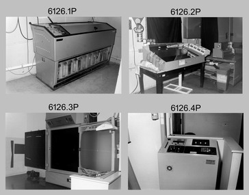
Orthophoto mapping provided the Survey Corps with the capability to produce map products quickly in the event of a crisis. These are four photographs of equipment used by the Army Survey Regiment to produce orthophotomaps. The Wild GZ1 orthophoto projector was introduced in 1973 and was the first equipment used to orthorectify colour and monochrome film aerial photography. Height profiles were originally produced on a PEB8 Stereo profiler and later were software generated. Photos of the PEB8 are available in Victorian Collections item 6222.17P, photos .5P and .6P. In the same era the IBM 1130 computer; OMI/Nistri AP/C-3 analytical plotter with coordinatograph, OP/C orthophoto projector and Zeiss Planimat D2 stereoplotters were introduced. Orthorectification is the process of removing geometric distortions and scale errors/variations from images. Images have tilt and relief distortions that make it difficult to compare accurately a map and an image of the same geographic area. Once an image is orthorectified, features on the image are shown in their planimetric locations. These four photographs of orthorectification equipment were taken at the Army Survey Regiment at Fortuna, Bendigo, c1975. Photo .1P and .3P were printed on photographic paper and scanned at 300 dpi. Photos .2P, .4P and .5P were on 35mm negative film and scanned at 96 dpi. They are part of the Army Survey Regiment’s Collection. .1) - Photo, black & white, c1975, Wild GZ1 orthophoto projector operated by CPL Phil Boyle. .2) - Photo, black & white, c1975, Wild GZ1 orthophoto projector. .3) - Photo, black & white, c1975, Wild GZ1 orthophoto projector. .4) - Photo, black & white, c1978, Zeiss D2 Planimat Stereoplotter. .5) - Photo, black & white, c1978, Zeiss D2 Planimat Stereoplotter..1P to .5P No annotations.royal australian survey corps, rasvy, army survey regiment, army svy regt, fortuna, asr -
 Bendigo Military Museum
Photograph - Army Survey Regiment’s Officers, Warrant Officers and Sergeants and Squadrons, at Fortuna, Bendigo, 1982
This is a set of six staff photographs of the Army Survey Regiment’s Officers, Warrant Officers and Sergeants, and each of its four Squadrons at Fortuna, Bendigo in December 1982. Note - Air Survey Squadron’s photo was probably taken in July 1982 as they appear in winter dress. Air Survey Squadron was responsible for aerotriangulation, photogrammetric feature extraction and the AUTOMAP 1 system. Typical tasks were flight planning the acquisition of aerial photography, pugging, mensuration and block adjustments, photogrammetric extraction of topographic features from aerial photography, digital feature editing, map compilation, operating the scanner/plotter, operating the AUTOMAP 1 system and computer programming by civilians. Cartographic Squadron was responsible for the production of the following military products: Joint Operation Graphics, small-scale RAAF Air Charts, large-scale topographic line maps and orthophotomaps. Cartographic technician tasks were scribing, compiling, retouching, masking, type setting, type stickup, terrain embossing, correcting and proving quality control. Headquarters Squadron was responsible for the planning and coordination of map production and contracts. It also performed administrative and support functions such as personnel administration, pay, finance, transportation, records, map Library, kitchens, messes and facility maintenance. It was staffed by Army personnel from RASvy, RACT, AACC, RAAOC and RAEME corps. Other supporting staff at this time included the RAAF Liaison Officer, RAN Liaison Officer and several civilians employed in administration, the Q-Store and grounds maintenance. A component of the Army Svy Regt’s cartographic map production was carried out by the Detachment, a sub-unit located at Bonegilla next to the School of Military Survey. Lithographic Squadron was responsible for the reproduction of map materials and printing of military map products. The main tasks undertaken by photographic technicians were photographic enlargements, reductions and duplication of map reproduction material and processing of aerial photography. Printing technician tasks included platemaking, offset printing, map stock despatching and proofing.This is a set of six staff photographs of the Army Survey Regiment’s Officers, Warrant Officers and Sergeants, and its four Squadrons, at Fortuna, Bendigo, 1982. The black and white photographs were printed on photographic paper and are part of the Army Survey Regiment’s Collection. The photograph was scanned at 300 dpi. No personnel are identified. No personnel are identified. .1P – Annotated on front “OFFICERS MESS DEC ’82” .2P – Annotated on back “SGTS MESS DEC ’82” .4P– Annotated on front “CARTO SQN DEC ’82” .5P– Annotated on front “HQ SQN DEC ’82”royal australian survey corps, rasvy, army survey regiment, army svy regt, fortuna, asr, air survey, carto, litho -
 Bendigo Military Museum
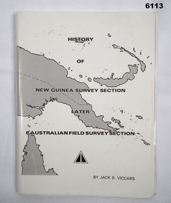
Booklet - History of the New Guinea Survey Section 1967 by LT Jack Viccars, Lt Jack Stewart Viccars, Circa 1967
Military surveying in New Guinea began in in WWII with the formation of the New Guinea Force Field Survey Section which later became 8th Australian Field Survey Section and later 2 Field Survey Section of 6th Army Topographical Survey Section. This history was written by LT Jack Viccars and member of the Unit.A4 Booklet, Black and white, 43 Pages, 4 Annexes, Map Indexes, Gloss Paper Cover, Bound by staplesForward by Brigadier D. Macdonald (Retd) AM, Royal Australian Survey Corps 1936-1967, Preface by LT Jack J.S. Viccarsroyal australian survey corps, rasvy, fortuna, army survey regiment, asr -
 Bendigo Military Museum
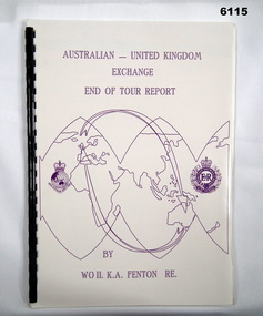
Administrative record - Australian - United Kingdom Exchange End of Tour Report by WO2 KA Fenton RE 1990, WO2 KA Fenton RE, 25.10.1990
A 2 x year personnel exchange program existed between RASvy and the Survey elements of the Royal Engineers UK. This is an end of Tour Report produced by WO2 KA Fenton RE of his experiences during his exchange tour. An A4 Booklet stylised map of the world with Corps Badges foe RASvy and Royal Engineers (UK), back cover overhead aerial Photo of Army Svy Regt, 14 Pages, 4 Annexes and an enclosureroyal australian survey corps, rasvy, fortuna, army survey regiment, army svy regt, asr -
 Bendigo Military Museum
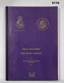
Administrative record - RASvy - Defense Mapping Agency Exchange Officer End of Tour Report MAJ D Bowen 1982, MAJ DH Bowen US Army Corps of Engineers, 3. 5. 1982
A 2 x year personnel exchange program existed between RASvy and the US Army Corps of Engineers. This is the End of Tour Report produced by David H Bowen, Major, Corps of Engineers, US Army Exchange Officer, Australia in 1982A4 Document, Plastic cover, Purple and gold, RASvy Badge emblem and Defense Mapping Agency Badge emblems in gold, 17 pages, 13 enclosures, black and white print, colour photos and mapsReport compiled by David H Bowen, Major, Corps of Engineers, US Army Exchange Officer, Australiaroyal australian survey corps, rasvy, fortuna, army survey regiment, army svy regt, asr -
 Bendigo Military Museum
Photograph - Photo Troop, Lithographic Squadron – Army Survey Regiment, Fortuna, Bendigo, 1986
This collection of 18 photos was most likely taken at Lithographic Squadron, Army Survey Regiment, Fortuna, Bendigo in 1986. The main tasks undertaken by technicians in Photo Troop were most likely enlargements, reductions and duplication of map reproduction material, and processing of aerial photography.This is a set of 18 photographs of Photo Troop personnel and equipment from Lithographic Squadron at the Army Survey Regiment, Fortuna, Bendigo, 1986. The photographs were on 35mm negative film and were scanned at 96 dpi. They are part of the Army Survey Regiment’s Collection. .1) - Photo, black & white, 1986, Film developer. .2) - Photo, black & white, 1986, Chromalin Proof equipment. .3) - Photo, black & white, 1986, KLIMSCH Commodore camera. .4) - Photo, black & white, 1986, KLIMSCH Commodore camera operator’s console. .5) - Photo, black & white, 1986, Film contact frame. .6) - Photo, black & white, 1986, Film processing chemicals. .7) - Photo, black & white, 1986, Unidentified technician. .8) - Photo, black & white, 1986, L to R: Unidentified technician, SPR Russell Pajank, SPR Carmel (Butler) Fauth. .9) - Photo, black & white, 1986, SPR Carmel (Butler) Fauth. .10) - Photo, black & white, 1986, SPR Carmel (Butler) Fauth. .11) - Photo, black & white, 1986, L to R: CPL Paul Baker, SGT Rob Bougumil. .12) - Photo, black & white, 1986, CPL Paul Baker. .13) - Photo, black & white, 1986, CPL Paul Baker. .14) - Photo, black & white, 1986, L to R: CPL Paul Baker, CPL Brian Paul. .15) - Photo, black & white, 1986, L to R: CPL Frank Lenane, SGT Rob Bougumil. .16) - Photo, black & white, 1986, CPL Brian Fauth. .17) - Photo, black & white, 1986, WO1 Trevor Osborne. .18) - Photo, black & white, 1986, L to R: SPR Kerron South, SGT Rob Bogumil.No personnel are identifiedroyal australian survey corps, rasvy, army survey regiment, army svy regt, fortuna, asr, litho -
 Bendigo Military Museum
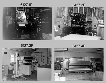
Photograph - Print Troop – Lithographic Squadron – Army Survey Regiment, Fortuna, Bendigo, 1986
This collection of twenty photos was most likely taken in Lithographic Squadron, Army Survey Regiment, Fortuna, Bendigo in 1986. Print Troop’s technicians were most likely operating the Komoni, Planeta or Ultra-MAN-III offset printing presses and working in the map despatch dock. Although these photos are not annotated most personnel are positively identified.This is a set of twenty photographs of Print Troop personnel and equipment from Lithographic Squadron at the Army Survey Regiment, Fortuna, Bendigo, 1986. The photographs were on 35mm negative film and were scanned at 96 dpi. They are part of the Army Survey Regiment’s Collection. .1) - Photo, black & white, 1986, Original Heidelberg Printing Press. .2) - Photo, black & white, 1986, Original Heidelberg Printing Press, unidentified technician. .3) - Photo, black & white, 1986, Heavy-duty paper guillotine. .4) - Photo, black & white, 1986, Polygraph Heavy-duty paper guillotine. .5) - Photo, black & white, 1986, Newkoni Komori Printing Press .6) - Photo, black & white, 1986, Ultra-MAN-III Printing Press, Russ Mollenhauer. .7) - Photo, black & white, 1986, Print roller cleaning tank .8) - Photo, black & white, 1986, Planeta Polygraph Printing Press .9) - Photo, black & white, 1986, Planeta Polygraph Printing Press .10) - Photo, black & white, 1986, Roy Hicks, unidentified technician, Steve Egan, Dale Hudson. .11) and .12) - Photo, black & white, 1986, L to R: Paper drilling machine, wire stitcher. .13) - Photo, black & white, 1986, Map Despatch dock, Greg Rowe. .14) - Photo, black & white, 1986, Print area, Pear Andersen. .15) - Photo, black & white, 1986, Map Despatch dock, Pear Andersen. .16) - Photo, black & white, 1986, Map Despatch dock, .17) - Photo, black & white, 1986, Map Despatch dock, Russ Mollenhauer. .18) - Photo, black & white, 1986, Map Despatch dock, unidentified technician. .19) - Photo, black & white, 1986, Map Despatch dock. Peter Dillon, Mick Minchin. .20) - Photo, black & white, 1986, Map Despatch dock.No personnel are identifiedroyal australian survey corps, rasvy, army survey regiment, army svy regt, fortuna, asr, litho, printing -
 Bendigo Military Museum
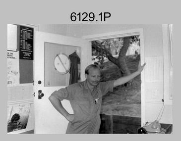
Photograph - Records Hut Personnel – Army Survey Regiment, Fortuna, Bendigo, c1986
These four photos of RaSVY personnel were taken inside the Records Hut, one of Headquarters Squadron’s work areas at the Army Survey Regiment, Fortuna probably in 1986. This building was located near the basketball court and probably at that time, held aerial photography archives, flight planning records, production data folders and final colour separated negatives of published maps.This is a set of two photographs of Records Hut personnel from Headquarters Squadron, Army Survey Regiment, Fortuna, Bendigo, 1986. The photographs were on 35mm negative film and were scanned at 96 dpi. They are part of the Army Survey Regiment’s Collection. .1) - Photo, black & white, 1986, Records Hut – SPR Brett Treneman. .2) - Photo, black & white, 1986, Records Hut – LCPL Bob Sheppard. .3) - Photo, black & white, 1986, Records Hut – L to R: LCPL Bob Sheppard, SPR Brett Treneman. .4) - Photo, black & white, 1986, Records Hut – L to R: LCPL Bob Sheppard, SPR Brett Treneman.No personnel are identifiedroyal australian survey corps, rasvy, army survey regiment, army svy regt, fortuna, asr -
 Bendigo Military Museum
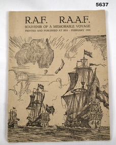
Booklet, Printed at sea and published at sea February 1944, RAF RAAF Souvenir of a Memorable Voyage, Feb 1944
Booklet has a cardboard cover, printed in black ink. A sketched image of the maps of Australia and New Zealand. Also drawings of 3 18th century sailing ships afloat. Under front cover “cabin 408 A Deck” followed by 8 signatures rear cover written in ink Mrs F.H. Weaver, Morgan Sth Aust, Australia “ Grenferry Cruise III Bon voyage and happy landings” ww2, raaf, raf -
 Bendigo Military Museum
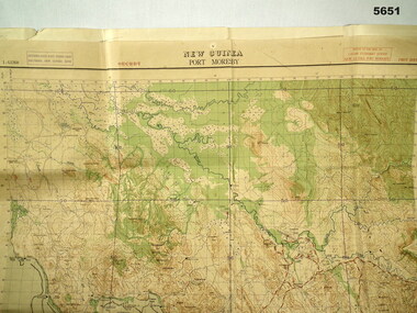
Map - MAP, PORT MORESBY 1943, 2/1st Aust Army TOPO SVY Coy, March 1943
In the collection re Capt R.A. Hanson VX111070, refer cat No 5646.3P for his service details.Map, Port Moresby area, colour, detailed, scale 1" - 1 mile, first Edition.In red, "1:63360 Standard series New Guinea, Port Moresby"map, new guinea, port moresby -
 Bendigo Military Museum
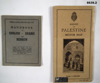
Booklet - HANDBOOK & ROAD MAP, April 1940
Sold by Ringarts Bookshop, Haifa1. This is a small pocket book, grey cover, black ink printing. It has words and phrases of colloquial Arabic and/or Hebrew. 32 pages. It is for Australian Imperial Forces in the Middle East. 2. Palestine Road Map. It has cardboard cover and opens out to a road map, scale 1:500,000. It has a drawing of the old section of Jerusalem on front cover.passchendaele barracks trust, 1. nr9430t, 2.9431t, ww2 -
 Bendigo Military Museum
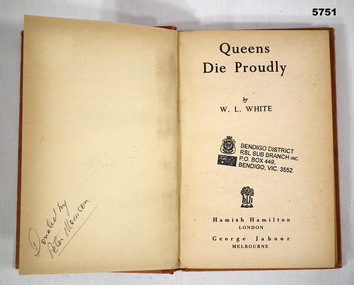
Book - BOOK, FLYING FORTRESS WW2, W. L. WHITE, "Queens Die Proudly", 1944
Book - account of the Flying Fortresses in the South West Pacific War WW2,Hard Cover book. Cover - cardboard, orange colour paper with black print on spine. 223 pages - cut, plain, off white paper. End papers - Illustrated, black and white map South-West Pacific. Front end paper and Title page - owner's stamp.Front end paper and Title page - black ink owner's stamp - "BENDIGO DISTRICT/ RSL SUB BRANCH INC/ PO BOX 449/ BENDIGO, VIC, 3552. Opposite Title page - handwritten black ink - "Donated by/ Peter Morrison".books, mikitary history, ww2, flying fortresses -
 Bendigo Military Museum
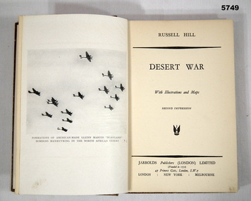
Book - BOOK, BATTLE CAMPAIGN WW2, Russell Hill, "Desert War", 1942
Book - Account of Battle campaign Tobruk, WW2.Hard cover book. Cover - cardboard, brown colour buckram cover with white print on spine (illegible). 140 pages - cut, plain, off white paper. Illustrated with black and white photographs and maps. End papers - illustrated sepia tones - map of Libya/Egypt (front) - map of Tobruk and battle. Campaign books.Front end paper - handwritten blue pen - "15-"books, military history, ww2, campaigns -
 Bendigo Military Museum
Book - BOOK, BIOGRAPHY WW2, C.O. Jennings (Captain "Mick" Jennings R.E.), "An Ocean Without Shores", 1950
"AN OCEAN WITHOUT SHORES" Tale of the adventures which befell two British soldiers in their attempt to escape from Singapore and the enemy.Hard cover book. Cover - cardboard, light brown colour buckram with dark blue print on spine and on front cover illustration - sketch of sailing dinghy. 223 pages - cut, plain, off white paper. Illustrated black and white photographs and maps. Owner's stamp - front end paper, title page and throughout pages. Front end paper/ Title page - owner's stamp - blue ink "RETURNED & SERVICES LEAGUE/MEMORIAL HALL BENDIGO" Pages throughout book - owner's stamp, black ink "TUBERCULAR SOLDIER'S AID SOCIETY/ INORPORATED".books, military history, ww2, biography -
 Bendigo Military Museum
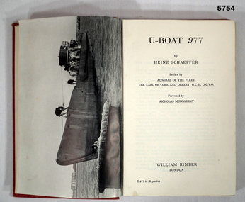
Book - BOOK, GERMAN NAVY WW1, Heinz Schaeffer, "U Boat 977", 1952 First Edition
'U-Boat 977' Autobiography by Heinz SCHAEFFER, the last Commander of U-Boat 977.Hard cover book. Cover - cardboard, red colour buckram with gold print on the spine. 207 pages, cut, plain, off white paper. Illustrated black and white photographs. Front end papers - illustrated blue print "The Structure of a U - Boat". Back end papers - illustrated blue print - map "The Last Voyage of U977" Front end papers - handwritten prices.Front end papers - handwritten - grey lead pencil "18/9" and in blue ink "15c".books, military history, ww2, german navy, autobiography -
 Bendigo Military Museum
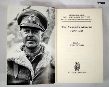
Book - BOOK, AUTOBIOGRAPHY WW2, JOHN NORTH, "The Alexander Memoirs /1940-1945", First Edition 1962
"THE ALEXANDER MEMOIRS" FIELD MARSHAL EARL ALEXANDER OF TUNIS K.G., P.C., G.C.B., O.M., G.C.M., C.S.I., D.S.O., M.C.Hard Cover book. Cover - cardboard, brown colour buckram, with gold print on the spine. 210 pages - cut, plain, off white. Illustrated - black and white photographs, maps and line drawings. front end papers - owner's stamp.Front end papers - owner's stamp - purple ink "T. MITCHELL/ 91 Roslyn St/ BURWOOD, 3125, VIC"books, military history, ww2, autobiographies -
 Bendigo Military Museum
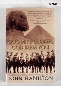
Book - BOOK - Gallipoli WW1, John HAMILTON, "Goodbye Cobber, God Bless You.", 2004/ 2005
"GOODBYE COBBER, / GOD BLESS YOU." "The Fatal charge of the Light Horse, Gallipoli, August 7th 1915."Soft cover book. Cover - cardboard. Gold, dark brown and light brown print on front, spine and back. Front cover - Illustrated sepia tones photographs of scenery and a group of Light Hors soldiers. 365 pages - cut, plain, off white paper. Illustrated black and white photographs and maps.books, military history, ww1, gallipoli peninsula -
 Bendigo Military Museum
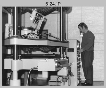
Photograph - Capturing Topographic Features with a Wild B8 – Army Survey Regiment, Fortuna, Bendigo, c1980
These four photographs of SPR Santina (Argetto) Straube capturing topographic features – plotting with a Wild B8 stereo plotter were most likely taken in c1980. Introduced in 1966, the Wild B8 stereo plotter was used for plotting topographic detail and contours. These analogue machines were manually controlled by adjusting the control knobs for the orientation of the 3D image. The B8s used a nine-inch square photo image on a film or glass diapositive which allowed highly accurate extraction of map features. At first, plotting by B8 and B9 equipment was undertaken at the aerial photography scale of 1:80,000 in pencil onto a controlled plotting sheet. Sheets were then inked up and reduced photographically to the 1: 100,000 publication scale for scribe impression production. In these photos SPR Santina (Argetto) Straube was plotting with a pencil or ink pen mounted at the far end of the pantograph arm. The plotting procedure was upgraded to direct plotting in ink with photographic reduction to publication scale. In 1975 four B8s were upgraded with tri-axis locaters as part of the Input Sub-system to enable digital extraction to AUTOMAP 1’s topographic database. When AUTOMAP 2 was introduced in 1982 these B8s were upgraded, and additional machines added to expand the Army Survey Regiment’s digital capture capability. This is a set of four photographs of a technician capturing topographic Features with a Wild B8 stereo plotter in Air Survey Squadron – Army Survey Regiment, Fortuna, Bendigo. 1980. The photographs were on 35mm negative film and were scanned at 96 dpi. They are part of the Army Survey Regiment’s Collection. .1) to .4) Photo, black & white, c1980. SPR Santina (Argetto) Straube operating a Wild B8 stereo plotter..1P to .4P – no annotations.royal australian survey corps, rasvy, army survey regiment, army svy regt, fortuna, asr, air survey, photogrammetry -
 Bendigo Military Museum
Album - Photographic Identification Guide (PIG) of the Gove Penisula (Sic) Peninsula, Army Topographic Support Establishment, May 1997
These photographs and a video were captured in May 1997 by Jeff Ruiz and Wayne Walsh from the Army Topographic Support Establishment (ATSE). The video taken onboard an aircraft has not been located at this time. A flight line diagram showing the path of the aircraft taking the video is enclosed in the album. The Army Topographic Support Establishment was created to perform some of the functions of the Army Survey Regiment.A Large Purple covered Album with gold dots containing maps, plans and coloured photographs of Gove Peninsula.royal australian survey corps, rasvy, fortuna, army survey regiment, army svy regt, asr, atse -
 Bendigo Military Museum
Manual - TM5 - 245: (US) Department of the Army Technical Manual - Map Reproduction, US Department of the Army, United States of America, War Office, 10 Sep 1956
Nine Chapters describing all aspects of Map Reproduction. 224 pages, including 8 appendices, glossary and indexA soft covered military manual, 224 pages of text, diagrams and annotated photographs"AHQ Survey Regiment" stamped inside front and back covers. Number "149" handwritten inside front cover.royal australian survey corps, rasvy, fortuna, army survey regiment, army svy regt, asr, mapping -
 Bendigo Military Museum
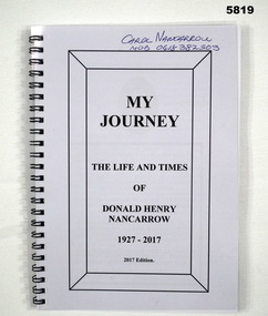
Book - AUTOBIOGRAPHY, BCOF, Donald Henry NANCARROW, “MY JOURNEY’, 2017
“MY JOURNEY’ ‘ THE LIFE AND TIMES/ OF DONALD HENRY NANCARROW/ 1927-2017” 2nd AIF Service No VX 96723. Enlisted 21 March 1945. AWOL. To Japan- age 19 years March 1946. “Tour of Duty” in Japan ended September 1947. Discharged 9 October 1947Soft cover book Cover- front clear hard plastic, back black cardboard, metal spiral bound. Title page - black print on white paper 97 Pages- cut, plain white paper. Illustrated black and white and colour photographs and maps Title Page- handwritten donors name Title Page- handwritten donors name- blue pen “ Carol NANCARROW/ Mob 0418 382 503books, military history, ww2, bcof, japan -
 Bendigo Military Museum
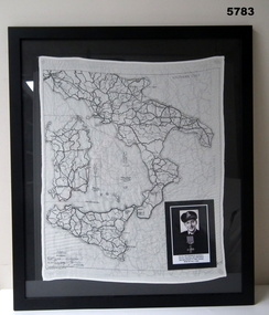
Map - MAP, ITALY, SILK, 1939 - 45
... goldfields The silk maps were carried by Aircrew. This item carried ...The silk maps were carried by Aircrew. This item carried by A.F. Goodall DFC, RAAF, refer Cat No 543.2 for his service details.Framed silk map of Italy and Sicily, black frame with black backing, map is in all black, the other side shows Northern Italy, inset is a photo of A.F. Goodall DFC, RAAF.silk, maps