Showing 1339 items
matching mount view
-
 Bendigo Military Museum
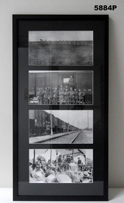
Photograph - PHOTOGRAPHS, GRINTON COLLECTION, FRAMED, 2008 - 2009
Frame 5. Photo 1. Lonely graves on a battlefield. This has been identified as "Vaire Wood cemetery" just south of the Somme at Vaire-sous-Corbie. Some 28 diggers from Vaire Wood were later reburied at Crucifix Corner Cemetery at Villers Bretonneux. Photo 2 and 3. Two photos, troop train luxury travel. This is possibly 45th quota men 'en route' from Gamaches to Havre in early 1919. From Havre they sailed for England on the "Prince George". Photo 4. Bert Grinton receiving his "DCM" from Lady Denman for actions around Clery on 31/8/1918. His CITATION reads: For conspicuous gallantry and devotion to duty near Clery on 31st August 1918. he became detached from his Company and joined another party in the advance. mainly through his assistance with a Lews Gun, they cleared an enemy trench, killing about 30 and capturing several machine guns. he got on top of the trench and under heavy fire silenced a field gun which was firing over open sights. This is from the official records in his service documents. Refer Cat No. 5880P for exhibition details. Refer Cat No. 1280 for Jack GRINTON Service Records.Photographs - black and white on paper. 4 photographs top to bottom. 1. Graves on a battlefield. 2 x 2. Troops in front of a rail wagon. View of rail wagons and troops. 3. Soldier receiving an award. Frame - timber with black colour paint, glass front, mount black colour cardboard. Backing cardboard with handwritten notation.Backing cardboard - handwritten, blue felt tip pen "5."framed photographs, grinton collection, ww1, 38th -
 Kiewa Valley Historical Society
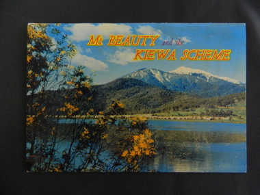
Booklet - Mt Beauty and the Kiewa Scheme x2
This booklet was produced to advertise Mt Beauty, the Kiewa Scheme & surrounding areas to visitors / tourists. The photos cover Falls Creek with snow, lifts and skiers - one with Spion Kopje Lodge. Also Tawonga Camping ground, Bogong Village, Mt Beauty Chalet, the Control panel at Kiewa Power Station, Clover Dam at No. 3 Power Station, the road to Falls Creek and a view of Mt Beauty township. The photos indicate what Mt Beauty and the Kiewa Valley and High Plains looked like c1950's during the construction of the Kiewa Hydro Electric Scheme. The area was recognised and encouraged as a tourist attraction especially Falls Creek enabling comparison with later photos and ideas. A fold down booklet postcard size of 12 colored photos - back to back of Mt Beauty, the Kiewa Scheme & surrounds. They fold in to form a front photo with title and a back card for stamp & address of addressee. On the back of the front photo are a few paragraphs describing the beauty, history and 'things to do' in the area for the visitor / tourist. mt beauty; kiewa scheme; tawonga; bogong; clover dam; kiewa valley; bogong high plains -
 Kiewa Valley Historical Society
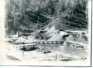
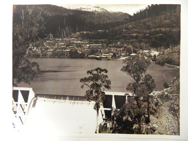
Photo - Junction Dam, 19/08/1940
Junction Dam was part of the Hydro Electricity Scheme during the 1940'sState Electricity Commission (S.E.C.V.) construction of the Kiewa Hydro Electric SchemeBlack and white photograph of Junction Dam construction. View from upstream.junction dam, bogong, secv -
 Kiewa Valley Historical Society
Photos - Mt Beauty Buildings in 1973. Set of 8, 1973
The shopping centre in Mt Beauty, both buildings and streetscape, have undergone significant changes since 1973. The kindergarten has undergone extensive remodelling, The Chalet has been replaced by Svarmisk Resort and Accommodation Spa. Tawonga hospital has undergone extensive renovation and is now Mt Beauty Hospital AND Kiewa Valley House. The Workman’s Club changed name to the Country Club and has since closed down. Hospital and Kiewa Valley House now occupy what is shown as a vacant lot opposite the motel which is now called Mt Beauty Motor Inn.The houses in Mt Beauty were brought in by the State Electricity Commission of Victoria when they constructed Mt Beauty Town for their workers building the Kiewa Hydro Electric Scheme. Mt Beauty is unique began as a construction town in the late 1940's.Colour photographs of various buildings in Mt Beauty taken in 1973 1. Workman’s Club 2. View over the pondage 3. Tawonga Hospital (Mt Beauty) 4. Mt Beauty Chalet 5. Mt Beauty Kindergarten 6. The Merjei Motel 7. 8 Valley Avenue 8. Shopping Centre Handwritten in ink on the back of photos 1. Workman’s Club 1973 (after the brick makeover) From the sports oval – the high school is to the right 2. A view over the pond 1973 3. Tawonga Hospital 1973 (Mt Beauty) 4. Mount Beauty Chalet 1973 5. Kindergarten 1973 6. The Merjei Motel 1973 7. Our house at 8 Valley Ave 1973, Owner after us erected the car port, let the front hedge run amok and vanquished the vegetable garden and citrus trees Dad created. 8. Shopping Centre 1973. At the end of the street is the hospital (believe it is now Mt Beauty Bush Nursing Hotel) mt beauty, workman's club, chalet, tawonga hospital -
 Kiewa Valley Historical Society
Photograph - Mount Beauty from Bogong Hill, 1950
The new State Electricity Commission construction camp at the head of the Kiewa Valley was for workmen on the second power station in the project expected to be the most modern and best equipped in Australia… In contrast to the early Kiewa days of horses and canvas tents, the new camp, with its modern amenities, compared favourably with any country town. Administration of the Kiewa Scheme was moved from Tawonga to Mount Beauty in 1946. The first house in Mount Beauty, in Hollonds Street, was occupied by the co-op store manager from November 1946. The new Mess Hall at Mt Beauty was opened with much ceremony in early November 1946. The houses up to Nelse street were erected from 1946 onward and then the township was extended beyond Nelse Street in 1950. The workmen's camp was enlarged in 1950 to the extent of providing accommodation for a total of 1,200.Shows early construction of the town of Mt. Beauty surrounded by farmland taken in 1950 during the early stages of construction of the Kiewa Hydro electric SystemBlack and white photograph - aerial view of Mt Beauty taken from Bogong Hill. Photograph framed by 6mm white boarder.Handwritten on back of photograph in black ink - Mt Beauty from Bogong Hill 1950 Printed on rear Volox 2428mt beauty, bogong hill, secv -
 Kiewa Valley Historical Society
Photograph - Mount Beauty from second gate. View down Kiewa Valley, 1950
The new State Electricity Commission construction camp at the head of the Kiewa Valley was for workmen on the second power station in the project expected to be the most modern and best equipped in Australia… In contrast to the early Kiewa days of horses and canvas tents, the new camp, with its modern amenities, compared favourably with any country town. Administration of the Kiewa Scheme was moved from Tawonga to Mount Beauty in 1946. The first house in Mount Beauty, in Hollonds Street, was occupied by the co-op store manager from November 1946. The new Mess Hall at Mt Beauty was opened with much ceremony in early November 1946. The houses up to Nelse street were erected from 1946 onward and then the township was extended beyond Nelse Street in 1950. The workmen's camp was enlarged in 1950 to the extent of providing accommodation for a total of 1,200.Shows early construction of the town of Mt. Beauty surrounded by farmland taken in 1950 during the early stages of construction of the Kiewa Hydro electric SystemBlack and white photograph - View from second gate down Kiewa Valley showing early buildings. Photograph framed by 6mm white boarderHandwritten in back of photo in blue ink - View from second gate down Kiewa Valley 1950mt beauty, kiewa valley, secv -
 Kiewa Valley Historical Society
Photographs x 2 - Afternoon tea visit to Towong Hill
Towong Hill Homestead is a 110-year-old Federation style mansion situated on a rock outcrop, with views of about 260 degrees. It was built over 2 years by grazier Walter Mitchell from bricks made from local clay dug from the river bank, to be the family home for his new bride Winifred. They established their home in 1904. After the death of Walter in 1917, Winifred relocated her family, but the homestead remained in the families hands. In 1935, Thomas Mitchell (1906-1984) returned home to Australia, a successful Lawyer, and married city girl, Elyne Chauvel, and settled himself back at his childhood home, Towong Hill. Thomas was a world champion slalom skier, had been a prisoner of the Japanese at Changi, and was elected for the Country Party in 1946 and served as attorney-general in the McDonald government. His wife Elayne (1913-2002) is best remembered for her Silver Brumby series of novels for children. But Elyne also wrote a substantial number of non-fiction works about the Snowy Mountains. Photographs demonstrate local Kiewa Valley residents enjoying a community visit to the historic homestead at Towong Hill which holds significance to the early history of the area. Also demonstrates a pictorial history of social activities undertaken during this period2 black and white photographs mounted on buff card. Kiewa Valley residents attending afternoon tea at Towong HillHandwritten in black pen underneath photo - T.W.Mitchell Towong Hill. Afternoon Teat w mitchell, towong hill, kiewa valley -
 Kiewa Valley Historical Society
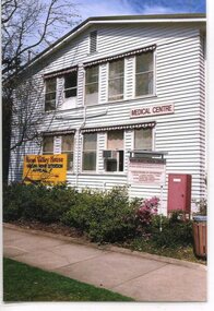
Photographs - Tawonga District General Hospital - Set of 21
In the early stages of the Kiewa Hydro-Electric Scheme the State Electricity Commission took over the financial and construction responsibility of the Tawonga District General Hospital building at a cost of 27,000 pounds. This included the removal and re-erection of the ex-military Bonegilla ward from Wodonga while in addition they carried out all the necessary building works that allowed the hospital to operate as a functional unit. The work was completed and handed over to the Hospital Committee of Management on September 1, 1949. Local residents raised 3,400 pounds through fund raising. The balance was met by the SEC and the Hospital and Charities Commission. The initial project was to provide for a basic temporary hospital which was later to include an Operating Theatre, Offices, Store, Mortuary and a Nurse’s Home, until the establishment of a permanent medical premises. Following the opening, 455 patients were admitted to the Tawonga District General Hospital and 254 operations were performed in the first year. The hospital relocated to Mount Beauty in the former SEC administration offices located in the town centre. Official opening of the 18 bed Tawonga District General Hospital on April 29 in 1961. Alpine Health CEO Mr Lyndon Seys oversaw the opening of the new Mount Beauty Hospital in November 2001 alongside Board of Management President Mr Andrew Randell, other board members and politicians. The Kiewa Hydro-Electric Scheme the State Electricity Commission played a pivotal part in the planning and initial funding of the Tawonga District General Hospital, with a view to providing medical support for its many workers on the Hydro scheme. Later, spouse and family members of workers were also able to access medical assistance The hospital was originally located in Tawonga away from the majority of the patients as the Hospital and Charities Board was not prepared to have it within the SEC controlled area. It was not until the gate at Tawonga South was taken down that the hospital was moved to the main centre of population at Mount Beauty. 1. Early nurses uniform; 2. Hospital Opening Ceremony; 3-7. Nursing Staff; 8. Delivery Room; 9. Mens Ward; 10.Enclosed Veranda; 11. Main Ward; 12-13. Kitchen; 14. Opening Ceremony 1949; 15.Original Hospital at Tawonga; 16-18. Relocated Hospital at Mt Beauty; 19. Rear of hospital and Matron’s quarters; 20. Hospital and Kiewa Valley House; 21. Renovated Hospital in 20001.Tawonga District General Hospital Tawonga; 2. Kiewa construction engineer Mr HHC Williams speaking at the opening of the hospital. Health Minister the Hon CP Gartside performed the official opening. L to R: TH Mitchell MLA; Manager of the hospital Mr RH Kronberg (obscured) Hon CP Gartside; CL McVilley; LT Knevitt; Matron AI Tarnish & W Sealey: 4. Dedicated Nursing Staff; 5. Nurse Campbell (nee Reid); 6. Sister Seager 1955 (nee Janice Burnett. First District Nurse; 7. L to R: Sister F Rosengrove; Sister J Griffiths; Matron AI Tarnish; Nurse D Satori; Nurse D Tregonning; Sister E Hill & Sister S O’Shannessy; 8. In the early years Tawonga District General Hospital had the second highest birth rate in Australia; 9. The men’s ward catered for men only in the early years of the hospitals operation; 10. The enclosed verandah at the original Tawonga District General Hospital allowed for an additional 10 beds; 11. Tawonga District General Hospital, Tawonga Main Ward. Ward ready and waiting for patients at Tawonga Hospital. Complete with lovely vases of flowers for every bed. Nice touch by the nurses; 12. Kitchen of Tawonga District General Hospital, Mt Beauty. The hospital kitchen provided meals for patients and a 3 course dinner for Meals on Wheels. In 1977, 11,795 meals were produced at an average cost of $2.60 per meal; 13. Tawonga District General Hospital, Tawonga. Kitchen. Kitchen staff employed in the old Tawonga District General Hospital 1949-1961; 14. The official opening ceremony of the Tawonga District General Hospital, 1949. The official ceremony was attended by a large number of residents and Tawonga District General Hospital was open for public inspection; 15. Original Tawonga District General Hospital transported form Bonegilla began operations in 1949; 16. In 1961, the Tawonga District General Hospital relocated to take a central position in the town of Mt Beauty in the former SEC Administration building; 19. The rear of the Tawonga District General Hospital and Matron’s house seen from Holland St, Mt Beauty during a snow storm in the mid 1960’s; 21. Tawonga District General Hospital & Kiewa Valley House, 2000. tawonga district hospital, mt beauty hospital, medical, health care, s.e.c. -
 Kiewa Valley Historical Society
Photographs - Demolition of the old Tawonga District General Hospital. Set of 8 colour photographs
In the early stages of the Kiewa Hydro-Electric Scheme the State Electricity Commission took over the financial and construction responsibility of the Tawonga District General Hospital building at a cost of 27,000 pounds. This included the removal and re-erection of the ex-military Bonegilla ward from Wodonga while in addition they carried out all the necessary building works that allowed the hospital to operate as a functional unit. The work was completed and handed over to the Hospital Committee of Management on September 1, 1949. Local residents raised 3,400 pounds through fund raising. The balance was met by the SEC and the Hospital and Charities Commission. The initial project was to provide for a basic temporary hospital which was later to include an Operating Theatre, Offices, Store, Mortuary and a Nurse’s Home, until the establishment of a permanent medical premises. Following the opening, 455 patients were admitted to the Tawonga District General Hospital and 254 operations were performed in the first year. The hospital relocated to Mount Beauty in the former SEC administration offices located in the town centre. Official opening of the 18 bed Tawonga District General Hospital on April 29 in 1961. The old weatherboard building was demolished around the late 1900’s to early 2000’s and replaced with a new modern brick building. Alpine Health CEO Mr Lyndon Seys oversaw the opening of the new Mount Beauty Hospital in November 2001 alongside Board of Management President Mr Andrew Randell, other board members and politicians. The Kiewa Hydro-Electric Scheme the State Electricity Commission played a pivotal part in the planning and initial funding of the Tawonga District General Hospital, with a view to providing medical support for its many workers on the Hydro scheme. Later, spouse and family members of workers were also able to access medical assistance The hospital was originally located in Tawonga away from the majority of the patients as the Hospital and Charities Board was not prepared to have it within the SEC controlled area and it was not until the gate at Tawonga South was taken down that the hospital was moved to the main centre of population at Mount Beauty.8 Colour photographs of the demolition of the original Tawonga and District Hospital situated in Mt Beauty circa 20001. No inscriptions 2. Side view of Tawonga District General Hospital, 1990’s 3. Demolition of the weatherboard hospital: Nurses station, ward and corridor 4. Demolition of the weatherboard hospital: kitchen & utility rooms 5. Demolition of the weatherboard hospital” front entrance & gardens 7. Demolition of the weatherboard hospital: Matrons House 8. No inscriptions tawonga & district general hospital; kiewa hydro electric scheme; mt beauty; -
 Kiewa Valley Historical Society
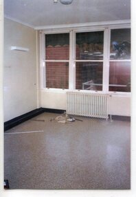
Photographs – Old Tawonga District General Hospital Mt Beauty. Set of 19 colour photographs
In the early stages of the Kiewa Hydro-Electric Scheme the State Electricity Commission took over the financial and construction responsibility of the Tawonga District General Hospital building at a cost of 27,000 pounds. This included the removal and re-erection of the ex-military Bonegilla ward from Wodonga while in addition they carried out all the necessary building works that allowed the hospital to operate as a functional unit. The work was completed and handed over to the Hospital Committee of Management on September 1, 1949. Local residents raised 3,400 pounds through fund raising. The balance was met by the SEC and the Hospital and Charities Commission. The initial project was to provide for a basic temporary hospital which was later to include an Operating Theatre, Offices, Store, Mortuary and a Nurse’s Home, until the establishment of a permanent medical premises. Following the opening, 455 patients were admitted to the Tawonga District General Hospital and 254 operations were performed in the first year. The hospital relocated to Mount Beauty in the former SEC administration offices located in the town centre. Official opening of the 18 bed Tawonga District General Hospital was on April 29 in 1961. The old weatherboard building was demolished around the late 1900’s to early 2000’s and replaced with a new modern brick building. Alpine Health CEO Mr Lyndon Seys oversaw the opening of the new Mount Beauty Hospital in November 2001 alongside Board of Management President Mr Andrew Randell, other board members and politicians. The Kiewa Hydro-Electric Scheme the State Electricity Commission played a pivotal part in the planning and initial funding of the Tawonga District General Hospital, with a view to providing medical support for its many workers on the Hydro scheme. Later, spouse and family members of workers were also able to access medical assistance The hospital was originally located in Tawonga away from the majority of the patients as the Hospital and Charities. Many SEC workers and their families have received medical care at Tawonga District General Hospital and Alpine Health over the years. A number of family members of SECV workers as well as other dedicated staff have provided high quality medical attention and support in all the facilities as nursing staff, support staff and volunteers. Many past staff members and their families still remain living in the Kiewa Valley area 19 Colour photographs of the Tawonga and District Hospital situated in Mt Beauty circa 2000. Including photographs of interior and of some staff members1. No markings 2. G Ryder at front entrance 3. Sister G Ryder in the Resuscitation Room 4. Nurse D Hateley in the Kitchen 5. Nurse D Hateley in the Casualty Room 6. Sister W McClelland in new nurse’s station 7. R Forrest, G Ryder, ?, M Ranton 8. Nurse D Hateley in the Pan Room 9. Tawonga District General Hospital: Resuscitation Room 10. Hospital Hallway 11. Empty Nurses Station 12. Tawonga District General Hospital: Nursery 13. Patient Tea Room 14, 15, 16, 17, & 18. No marking mt beauty district hospital, tawonga district hospital, bonegilla ward, ryder family -
 Kiewa Valley Historical Society
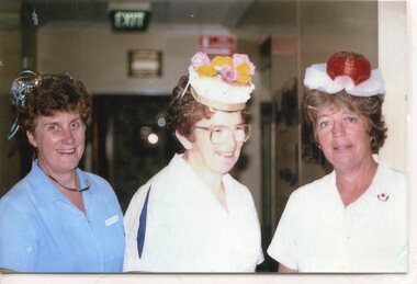
Photographs – Photographs of staff from Tawonga District General Hospital & Alpine Health – Set of 13 colour photographs
In the early stages of the Kiewa Hydro-Electric Scheme the State Electricity Commission took over the financial and construction responsibility of the Tawonga District General Hospital building at a cost of 27,000 pounds. This included the removal and re-erection of the ex-military Bonegilla ward from Wodonga while in addition they carried out all the necessary building works that allowed the hospital to operate as a functional unit. The work was completed and handed over to the Hospital Committee of Management on September 1, 1949. Local residents raised 3,400 pounds through fund raising. The balance was met by the SEC and the Hospital and Charities Commission. The initial project was to provide for a basic temporary hospital which was later to include an Operating Theatre, Offices, Store, Mortuary and a Nurse’s Home, until the establishment of a permanent medical premises. Following the opening, 455 patients were admitted to the Tawonga District General Hospital and 254 operations were performed in the first year. The hospital relocated to Mount Beauty in the former SEC administration offices located in the town centre. Official opening of the 18 bed Tawonga District General Hospital on April 29 in 1961. Kiewa Valley House nursing home was officially opened on March 6th, 1985, with a new lounge extension opening in May, 1993. Prior to this, residents had to travel to Beechworth, Wangaratta or Wodonga for care. The old weatherboard building was demolished around the late 1900’s to early 2000’s and replaced with a new modern brick building. Alpine Health CEO Mr Lyndon Seys oversaw the opening of the new Mount Beauty Hospital in November 2001 alongside Board of Management President Mr Andrew Randell, other board members and politicians.The Kiewa Hydro-Electric Scheme the State Electricity Commission played a pivotal part in the planning and initial funding of the Tawonga District General Hospital, with a view to providing medical support for its many workers on the Hydro scheme. Later, spouse and family members of workers were also able to access medical assistance. Many SEC workers and their families have received high medical care at Tawonga District General Hospital and Alpine Health and/or as residents of Kiewa Valley House over the years. A number of family members of SECV workers as well as other dedicated staff have provided high quality medical attention and support in all three facilities as nursing staff, support staff and volunteers. Many past staff members and their families still remain living in the Kiewa Valley area Set of 13 colour photographs of past nursing staff and support staff from Tawonga District General Hospital, Kiewa Valley House & Alpine Health 1. Marg Hickey, Barbara Clark & Margaret Ranton 2. Cheryl Clutterbuck & Rosemary Forrest 3. Margaret Ranton 4. Margaret Ranton holding unknown infant 5. Gwen Goss 6. Barbara Clark & Margaret Ranton 7. Margaret Ranton, Sue Zeinert & Jenny Piera 8. Margaret Ranton, Gloria Ryder & Jenny Piera 9. Sue Wesley, Ruth Barton, Margaret Ranton, Rosemary Forrest & Nola Henry 10. F Bogaski & H Sigmund 11. Maintenance Supervisor H Sigmund 12. Gardener Fred Keat & Handyman Joe Trezise (1977) 13. Nursing staff in new hospital 1-9 No markings 10 F Bogaski & H Sigmund 11. Maintenance Supervisor H Sigmund 12. Gardener Fred Keat & Handyman Joe Trezise (1977) 13. Nursing staff in new hospital tawonga district general hospital, kiewa valley house, alpine health -
 Kiewa Valley Historical Society
Photographs – Bogong High Plains - Set of 16 black and white photographs mounted back and front on 3 pieces of heavy black card likely removed from a photograph album
After World War II, the Kiewa Hydro-Electric Scheme was started in the Kiewa River Valley by the State Electricity Commission of Victoria. On land previously used only for summer cattle grazing in the natural alpine grasslands, the first ski lodge was built in 1948 by workers from the hydro scheme as skiing was a popular recreation. Many of the hydro employees were of European background and had grown up enjoying skiing and snow sports in their homelands and were keen to continue to pursue their winter sports interests. The first lift, a rope tow, was built at Falls Creek in 1951 and the first chairlift in Australia was constructed there in 1957. Two T-Bars were opened in 1961. In 1964, the Victorian Municipal Directory recorded that Falls Creek had 29 ski club lodges and 16 commercial lodges. The area became a popular tourist destination for both winter and summer sports.Employees of the State Electricity Commission of Victoria in the Kiewa River Valley were the earliest skiers on the Bogong High Plains and built one of the first ski lodges at Falls Creek. They were amongst those pivotal in the development of the skiing and tourist industry at Falls Creek and on the Bogong High Plains. Black and white photographs of varying sizes mounted decoratively on heavy black Card. Some pages display a brief description printed in white ink 1. 4 photographs- displayed diagonally across page. 2 pictures of a group of men standing in the snow in front of a car with a loaded trailer behind. 1 photo of skiers. 1 photo of show hanging in tree branches. 2. 2 photographs- showing Upper Kiewa Road with snow in the background 3. 3 photographs- of skiers and 1 photo of 2 of men posing in the snow & 1 photo of 2 men posing shirtless in warmer weather. 4. 2 photographs- arranged diagonally on page showing early buildings and construction at Bogong Village 5. 2 photographs- 1 showing view of Bogong Village from higher up the mountain. 1 showing early Bogong High Plains road 6. 1 photograph- showing view down along Kiewa Valley from higher up in the mountains 1. Handwritten in white ink – A TRIP TO THE PLAINS 2. Handwritten in white ink – UPPER KIEWA ROAD MT FAINTER IN BACKGROUND 3 – 6. No markings bogong village; upper kiewa road; bogong high plains; falls creek; skiers -
 Kiewa Valley Historical Society
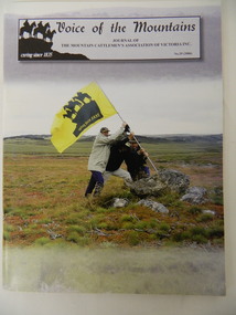
Journal - The Mountain Cattlemen's Association of Victoria - No. 29 (2006) x2, Voice of the Mountains, 2006
The High Plains Cattlemen's licenses expired in Aug. 2005 ending a 170 year history of alpine grazing in Victoria and Australia. This journal, No. 29, is published by the Mountain Cattlemen's Association "caring since 1835" and has articles and histories of the families and their activities. Many of the Mountain Cattlemen lived / live in the Kiewa Valley. This journal contains their history, activities and views.Stiff colored cardboard cover journal with title at the top of the cover. Consists of 56 pages. Centre 4 pages not numbered and are on yellow paper. Black and white photos are included.mountain cattlemen, bogong high plains, horses -
 Kiewa Valley Historical Society
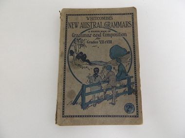
Book, Whitcombe's New Austral Grammars - a Fourth Book of Grammar and Composition for Grades V11 & V111
Educational book for Grammar and Composition. Published for the Victorian Education Department.Historical: Comparative with other text books used in schools in different eras.A greeny/grey book with cardboard cover and with bluish picture of 3 children sitting on a fence looking at a view of the countryside. The countryside is in a solid circle of blue. Border is black with ladder-like line about 2 mm wide. Bottom right corner in circle coloured blue is (in black) 2/- Title: in black Whitcombe's / New austral Grammars / A Fourth Book of / Grammar and Composition / for / Grades VII & VIII. See physical description.education. school. victorian education department. english. grammar. composition. grades 7 and 8. -
 Kiewa Valley Historical Society
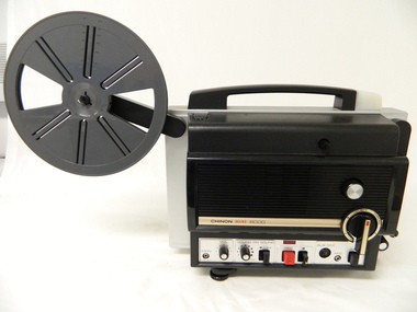
Film Projector
This film sound projector was used to show 8mm films. The film would be projected onto a screen for viewing.This projector was owned and used by a resident of the Kiewa Valley during the 1970's.Black plastic box with a handle on the top and a lever that comes out for the reel to be attached. On the front there are 5 black 'push in' knobs and 1 red 'push in' knob. Also 2 round black rotating knobs that turn. It has 3 legs and 2 outlets at the back. Included in the box are:- 1. Booklet 'Chinon Sound 8000' Instructions. 2. 1 black reel. 3. 4 movies- 'The Blue Max'; 'Spitfire'; 'Tora Tora Tora'; and ' The Queen's Silver Jubilee Air Pageant 1977'.film. sound projector. movies. -
 Kiewa Valley Historical Society
Photo - Early photo of Bogong Township x2
Bogong Village was built for the workers of the State Elecricity Commission of Victoria who were employed to construct the Kiewa Hydro electric Scheme. This photo shows their homes and offices etc., Lake Guy and the spillway during construction days.Bogong village was built as part of the Kiewa Hydro Electric Scheme. This photo gives a view of the village when it was at its peak. Large photo of Mt Bogong Township with snow on the mountain in the background and the spillway over-flowing in the foreground. Some small trees amongst those burnt by the 1939 bushfire. (2 photos - one an enlarged copy)bogong village. kiewa hydro electric scheme. s.e.c.v.. lake guy. -
 Eltham District Historical Society Inc
Photograph, Fay Bridge, Moor-rul Viewing Platform, Garden Hill, Kangaroo Ground, n.d
OPENING OF THE VIEWING PLATFORM AT KANGAROO GROUND Nillumbik Council has advised that the viewing platform at Kangaroo Ground 27km NE of Melbourne is to be opened to the public on Wednesday, March 26th 2008 (Melway 271 , G10). The function of the platform is to provide shelter adjacent to the War Memorial Tower whilst allowing all people to enjoy the stunning panoramic views. From the platform you. can see the Dandenongs, the city of Melbourne, the You Yangs, Mount Macedon, the Kinglake Ranges and the Mt Baw-Baw Ranges where the Yarra River starts. This landscape covers all the ancestral lands of the Wurundjeri and some of the wider Kulin nation land. The platform has been given the name Moor-rut, a name which described the fertile soils of the Kangaroo Ground area in contrast to the poorer (Silurian) country of its surrounds, which the Wurundjeri knew as 'Nillumbik' or less rich country. The full 360 degree view can be seen from the adjacent Tower of Remembrance which has 53 stairs. The viewing platform however can be accessed by wheelchair. Inside the viewing platform there are eight double sided interpretive panels giving the history and information regarding this special area. The viewing platform's interpretive panels set out the Aboriginal and European history of the area and also the geology and the local flora and fauna, so that the casual visitor comes away understanding more about this significant part of Victoria. The concept of the viewing platform is part of the refurbishment project for the Kangaroo Ground War Memorial Park which has taken place since 1997 with the active approval and financial assistance of the Nillumbik Shire Council. This project has been guided by an Advisory Committee with volunteer community representatives from the local Historical Societies, the Country Fire Authority, the Returned Services League and the Wurundjeri people. Other allied groups such as the Nillumbik Reconciliation Group have been called upon for their expertise. The initial idea for the viewing platform came from Dean Stewart when he was the caretaker while living at the park. He discussed this idea with local author Mick Woiwod and Harry Gilham of Eltham District Historical Society when they were planning the refurbishment of the War Memorial Park in 1996. When the committee was formalised by the Nillumbik Council in 1997, Nicholas Pelling, representing the CFA and RSL, joined the group. Dennis Ward, local architect, then volunteered to develop the concept plan for the refurbishment of the park and later drew up the plans for the viewing platform. The Kangaroo Ground War Memorial Park and its Tower of Remembrance is located on one of the highest locations in the Yarra Valley. The Tower of Remembrance is a unique war memorial constructed from local stone standing 14 metres high. It was built in the style of a Scottish watchtower reflecting the strong Scottish influence of the first European settlers of the district from the 1840s onward. The park was opened in 1921 and the Tower of Remembrance was dedicated in 1926 recognising the local people who served in the First World War. Those who served in the Second World War were recognised by plaques dedicated in 1951 and more recently those who served in Korea, Borneo, Malaya and Vietnam by plaques unveiled in 2001. Harry Gilham, Advisory Committee Convenor - Eltham District Historical Society Newsletter N0 179 March 2008fay bridge collection, garden hill, kangaroo ground, memorial park, moor-rul viewing platform -
 Eltham District Historical Society Inc
Photograph (Item) - Print, Ed Stuyfbergen, View Of Eltham Tavern, 1988
View looking east from Montmorency towards the Eltham Tavern (Eltham Hotel) Ed Stuyfbergen 1988 Entrant No. 26 Ref: Series 34, Items 13, 14, 66-68 SHIRE OF ELTHAM COMMUNITY PHOTOGRAPHIC SURVEY Photography is an artform which many of us practice, sometimes purely for artistic pursuit, sometimes to record the people and events in our lives. In 1988, as part of a local Bicentennial project, the Shire of Eltham conducted the Eltham Community Photographic Survey. Up to 100 entries were to be selected by a panel of photographers for entry into the Eltham Photographic Survey Exhibition. Entries had to be submitted by May 13, 1988. Entrants whose images were selected for the exhibition were contacted and requested to further submit an entry form providing entrant’s name, area of residence, age, and proposed captions. These details were then used to produce labels for the exhibition mounts. Where negatives had not been supplied, these were requested to support the display of printed enlargements mounted on 10” x 8” cardboard. The mounted prints were made available post exhibition for sale at $8.50 each for colour prints and $7.00 for B&W prints. Residents in the Shire were invited to collect a free roll of film and take a photograph of what they either liked or did not like about the area. A total of 160 entrants submitted multiple entries for the exhibition. Of those selected for exhibition, entrants ranged in age from 9 to 70 years. All custom colour and black and white printing for the exhibition was completed by Wattle Studios of Eltham. The Eltham Photographic Survey was jointly auspiced by the Shire of Eltham and Wattle Studios, of 953 Main Road, Eltham. The project was greatly assisted by: • David McRitchie, Media Studies Lecturer Victoria College, Rusden Campus. • Ian and Annette Toohill of Wattle Studios • Tracy Naughton, Eltham Community Arts Officer • Neville Emerson Pty. Ltd. • Superior Press, Eltham • Kodak Australasia Pty. Ltd. • Agfa Gevaert Ltd. • Townsend Colourtech Pty. Ltd. • The Australian Bicentennial Authority • Eleanor Bowers, Secretary, Eltham Arts Council The exhibition was placed on display in the Woolworths Arcade, Eltham between Monday June 6th and Saturday June 11, 1988. It was also intended to hold the exhibition at a venue in the Shire’s North Riding from Monday, June 20 to Friday June 24. It was then displayed at the Were Street Theatre, Montmorency from Friday, June 24 to Thursday, July 7. Series 34: Eltham Community Photographic Survey 1988 - Prints & Documentation Series consists of 117 photographs of Shire scenes taken by members of the community. Items I - 41 are larger photographs mounted on card, which were exhibited. Items 42 - 117 are unmounted copies, alternative takes and other entries. Corresponding negatives contained in Series 35: Eltham Community Photographic Survey 1988 – Negatives which consists of 267 colour and B&W negatives and one colour slide of Shire scenes taken by members of the community. The negatives are arranged by the entrant number of the photographer. The Eltham Community Photographic Survey collection is significant to the local community as it was curated by the local community - ordinary people of all ages - representing what they liked and did not like in the area where they lived. It represents an unfiltered representation of the Shire of Eltham as it was in 1988. It also represents one of many projects as part of the national programme of events and celebrations to commemorate the bicentenary. It is a time capsule of life in the 1980s of this urban and rural municipality in Melbourne's north. Front: Entrant No. and name on printed label Rear: Entrant No., name and address on printed label; also 'Series 34' and the 'Item No.' in pencilshire of eltham archives, bicentennial project, eltham, eltham community photographic survey, eltham photographic survey exhibition, series 34, series 35, ed stuyfbergen, eltham hotel, eltham tavern, film - ilford fp4, scan - 35mm negative -
 Eltham District Historical Society Inc
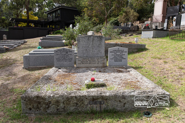
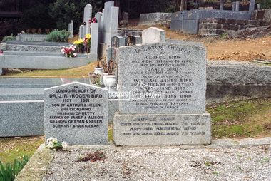
Photograph, Peter Pidgeon, Graves of George and Janet Bird and family, Eltham Cemetery, Victoria, 5 April 2021
George Bird was born in England in 1845 and arrived in Australia in 1856 as a child of assisted migrants. Soon afterwards he came out to Eltham to live with his uncle George Stebbings, working for him as bricklayer's assistant in building, amongst others, Shillinglaw Cottage and the Anglican and Methodist Churches in Eltham. He later purchased 72 acres at the eastern end of Pitt Street (bounded by Eucalyptus Road, Mount Pleasant Road and present-day Rockliffe Street) and established the property ‘View Hill’, which was worked as a mixed farm and orchard (including berries). In 1878 he married Janet Kilpatrick, who had emigrated from Scotland. They had ten children, three of whom died in infancy. The wedding in 1904 of their eldest surviving daughter Sarah (‘Sis’) to Edward Pepper appears to have been quite a society event. George was a staunch Methodist and was a Church Steward and a Sunday School Superintendent in about 1890. Janet died in 1915 and George died in 1920 (though his gravestone says 1921). George's will stated that his property was to be divided between all his children in equal shares. This necessitated subdivision of the View Hill property, which took place progressively between 1922 and 1926. One son, George Hugh Bird, operated a drapery store in Main Road (near Bridge Street) in around 1915. Later, in the 1920s, he ran a greengrocer's shop (also selling confectionery) in Main Road opposite Eltham Station. It was the first shop in Eltham to have plate glass windows. At the same time, his brother Reg had a grocery store on the station side of Main Road. George and Janet are buried together in a family plot in Eltham Cemetery. Several descendants are also buried in the cemetery. In Loving Memory Of George Bird Died 5 December 1921 aged 76 years And his beloved wife Janet Bird Died 5 Sept 1915 aged 57 years Also their children William James Bird Died 25 Feb 1888 aged 8 years Mary Jane Bird Died 8 Oct 1891 aged 7 years Pte Edwin John Bird Killed in action in the Great War 11 Aug 1918 aged 30 years Buried in France And on the base stone George Hugh Bird Died 26 Feb. 1965. Aged 79 years Arthur Andrew Bird Died 25 Mar. 1970 Aged 75 years To the left In Loving Memory of Dr. J. R. (Roger) Bird 1927 2001 Son of Arthur & Helen (nee Lyon) Bird Husband of Betty Father of Janet & Alison Grandpa of Evan & Helen Scientist & Gentleman To the right In Loving Memory of Harold Edwin Bird OAM 1922 - 2015 Son of Arthur & Helen (nee Lyon) Bird Husband of Yvonne Father of Estell & Russell In our hearts Forever moreBorn Digitaleltham cemetery, gravestones, arthur andrew bird, arthur bird, edwin john bird, george bird, george hugh bird, harold edwin bird, helen bird (nee lyon), j. r. (roger) bird, janet bird (nee kilpatrick), william james bird, yvonne bird -
 Eltham District Historical Society Inc
Negative - Photograph, Harry Gilham, Grave of Christopher Watson, Eltham Cemetery, Victoria, 1 Aug 2007
George Bird was born in England in 1845 and arrived in Australia in 1856 as a child of assisted migrants. Soon afterwards he came out to Eltham to live with his uncle George Stebbings, working for him as bricklayer's assistant in building, amongst others, Shillinglaw Cottage and the Anglican and Methodist Churches in Eltham. He later purchased 72 acres at the eastern end of Pitt Street (bounded by Eucalyptus Road, Mount Pleasant Road and present-day Rockliffe Street) and established the property ‘View Hill’, which was worked as a mixed farm and orchard (including berries). In 1878 he married Janet Kilpatrick, who had emigrated from Scotland. They had ten children, three of whom died in infancy. The wedding in 1904 of their eldest surviving daughter Sarah (‘Sis’) to Edward Pepper appears to have been quite a society event. George was a staunch Methodist and was a Church Steward and a Sunday School Superintendent in about 1890. Janet died in 1915 and George died in 1920 (though his gravestone says 1921). George's will stated that his property was to be divided between all his children in equal shares. This necessitated subdivision of the View Hill property, which took place progressively between 1922 and 1926. One son, George Hugh Bird, operated a drapery store in Main Road (near Bridge Street) in around 1915. Later, in the 1920s, he ran a greengrocer's shop (also selling confectionery) in Main Road opposite Eltham Station. It was the first shop in Eltham to have plate glass windows. At the same time, his brother Reg had a grocery store on the station side of Main Road. George and Janet are buried together in a family plot in Eltham Cemetery. Several descendants are also buried in the cemetery. In Loving Memory Of George Bird Died 5 December 1921 aged 76 years And his beloved wife Janet Bird Died 5 Sept 1915 aged 57 years Also their children William James Bird Died 25 Feb 1888 aged 8 years Mary Jane Bird Died 8 Oct 1891 aged 7 years Pte Edwin John Bird Killed in action in the Great War 11 Aug 1918 aged 30 years Buried in France And on the base stone George Hugh Bird Died 26 Feb. 1965. Aged 79 years Arthur Andrew Bird Died 25 Mar. 1970 Aged 75 years To the left In Loving Memory of Dr. J. R. (Roger) Bird 1927 2001 Son of Arthur & Helen (nee Lyon) Bird Husband of Betty Father of Janet & Alison Grandpa of Evan & Helen Scientist & Gentleman To the right In Loving Memory of Harold Edwin Bird OAM 1922 - 2015 Son of Arthur & Helen (nee Lyon) Bird Husband of Yvonne Father of Estell & Russell In our hearts Forever moreeltham cemetery, gravestones, memorials, arthur andrew bird, arthur bird, edwin john bird, george bird, george hugh bird, harold edwin bird, helen bird (nee lyon), j. r. (roger) bird, j.r. (roger) bird, janet bird, janet bird (nee kilpatrick), william james bird, yvonne bird -
 Eltham District Historical Society Inc
Photograph - Digital Photograph, Jim Connor, Eltham Cemetery Trust's launch at Montsalvat of Our Eltham - Artistic Recollections, 21 September 2017
Our Eltham - Artistic Recollections by Jim Connor, EDHS newsletter No. 236 October 2017 The Eltham Cemetery Trust, established in 1858, selected the existing burial site at Mount Pleasant Road on high ground overlooking the village of Eltham. The first recorded burial took place in 1861 in the Church of England section. Headstones depict the names of many early and well known local families. In recent years the Trust has encouraged the use of creative artistic elements within the natural bushland environment in their landscaped grounds adjoining Montsalvat. Their ongoing vision has been to offer the local communty a fresh and unique relationship to the Cemetery. On Thursday 21st September 2017 their latest commissioned art project titled ‘Our Eltham - Artistic Recollections’ was unveiled. It is a collection of panels collaboratively created by artist Nerina Lascelles and ceramicist Linda Detoma. The project was designed and constructed by Leigh Wykes using Australian stone with ironwork by Neil Carter. All contributors to this installation, located adjacent to the car park near Metery Road, are residents of the Eltham area. Our Eltham - Artistic Recollections is described as a celebration of life in the Shire since the opening of the Eltham Cemetery more than 150 years ago. Depicting scenes of life in and around Eltham, the collection offers deeper connections to the Eltham area through a series of visual narratives of Eltham’s past, environment and community. The project involves the artistic interpretation by Nerina Lascelles of historic and current images symbolically intermixed with locally indigenous flowers and plants. These are displayed on thirty-one ceramic panels by Linda Detoma, mounted within an iron fence by Neil Carter, upon an attractive rock wall constructed by Leigh Wykes. The Eltham District Historical Society is pleased to have contributed to this project. Russell Yeoman and Jim Connor from our Society have collaborated with Liz Pidgeon, Local and Family History Librarian at Yarra Plenty Regional Library on a selection of photographs, many from the Shire of Eltham Pioneers Collection we hold in partnership, located at Eltham Library. We also provided information on the images chosen. The Eltham Cemetery Trust has produced a booklet about this artwork, which can be viewed on the Cemetery website at: http://www.elthamcemetery.com/oureltham/#1 Our Eltham - Artistic Recollections is a significant monumental installation, which will encourage visitors to come to view this outstanding combination of local creative skills, set within the attractive grounds of the Eltham Cemetery. jim connor collection, eltham cemetery trust, montsalvat, our eltham artistic recollections, 2017-09-21 -
 Eltham District Historical Society Inc
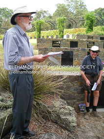
Photograph, Fay Bridge, EDHS Heritage Excursion Eltham Cemetery, 5 March 2016
The Eltham Cemetery Trust, established in 1858, selected the existing burial site at Mount Pleasant Road on high ground overlooking the village of Eltham. The first recorded burial took place in 1861 in the Church of England section. Headstones depict the names of many early and well known local families. On Saturday 5th March 2016 Harry Gilham again lead members and visitors on a heritage excursion through parts of the cemetery, while providing background information on selected individuals buried there. Harry’s cemetery walks have always been popular, and members and visitors were encouraged to come along and experience the tranquil surroundings of this picturesque cemetery. We were also able to view the recently installed sculpture titled ‘A Currawong Takes Flight’ by Michael Wilson located at the highest point of the fence-lined border between Montsalvat and the cemetery. It is close to the last bronze sculpture by Matcham Skipper, titled ‘Young Man Awakening’, commissioned by the Eltham Cemetery Trust to celebrate the 150th Anniversary of the cemetery in 2008. As an addition, we also met the artists and stonemason and given a brief background into the Trust’s newest art project installation titled “Our Eltham – Artistic Recollections” which will feature ceramic panels containing artwork with a local history theme. The work is the joint creation of artist Nerina Lascelles and ceramicist Linda Detoma, supported with stonework by Leigh Wykes and steelwork by Neil Carter, all skilled local Nillumbik artisans.fay bridge collection, 2016-03-05, eltham cemetery, geoff watt, jim connor, leigh wykes, linda detoma, nerina lascelles, young man awakening, harry gilham -
 Eltham District Historical Society Inc
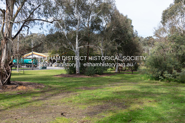
Photograph, Peter Pidgeon, Site of former Eltham Tennis Court, Wingrove Park, 2 Aug. 2022
View looking through Wingrove Park from near the Diamond Creek Trail towards the Coles Express Service Station and Mount Pleasant Road intersection. Comparison photo: SEPP_0720 Eltham Tennis Court, c.1909 and SEPP_0721 - Eltham Tennis Court, Lady Premiers 1909-1910 The tennis courts were located in Bremner’s Flats, present day Wingrove Park. The Eltham Lawn Tennis Club was formed on a Saturday evening, the 29th of October, 1898 at a meeting held at the Eltham State school. Twenty members were enrolled, and eight more shortly afterwards. Officers and a committee were duly elected, and the Treasurer was instructed to purchase the necessary requisites without delay. By the end of the first week in November all the requisites were to hand, two courts were marked out, and practice begun. The formal opening of the Courts of this Club took place on Saturday, November 12, 1898, when 26 members and their friends assembled. Part of a presentation by Peter Pidgeon to the Society, 13 August 2022 showcasing a series of photographs taken by John Henry Clark over the period 1895 to 1930. John Henry Clark was the youngest of three boys born to William Henry Clark (1823-1877) and Maria White (1843-1914). He and his brothers, William Charles Clark (1872-1945), Clement Kent Clark (1874-1912) operated a photography business (Clark Bros.) from 25 Thomas Street, Windsor near Prahran during the period c.1894 to 1914. Following death of Clement in September 1912 and their mother in 1914, the Clark Bros business appears to have dissolved, the premises demolished, and a new house was under construction in 1915. John set up business independently in 1914 operating out of 29 Moor Street, Fitzroy where he is registered in the 1914 and 1915 Electoral Rolls. By 1916 John had relocated to Eltham where he continued his practice as a photographer and took many of the early images around the district of Little Eltham. Around 1930 John changed professions and opened a small cobbler's shop in 1931 near the pond opposite Dalton Street adjacent to the Jarrold family cottage. He never married and continued his profession as a bootmaker from this little shop, maintaining a close relationship with Mrs Jarrold for the rest of their lives. His bootmaker shop remains today beside the Whitecloud cottage and is one of only three remaining shops in the area from the early 20th century.Comparative photo taken 2022 with one taken from same location over 100 years earlier by noted local photographer J.H. ClarkBorn Digitalbible street, eltham, j.h. clark photo (2022), bremner's flat, eltham lawn tennis club, eltham tennis court, main road, mount pleasant road, tennis court, wingrove park -
 Eltham District Historical Society Inc
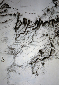
Slide - Photograph, Old map of Diamond Creek catchment, c.Sep. 1989
Part of a slide show presentation "Bridges & Waterways of the Shire" by Russell Yeoman to the 13 September 1989 Society meeting. The presentation included slides of historic photos from the Shire of Eltham Pioneers collections as well as several recent views.35mm colour positive transparency (1 of 33) Mount - Agfa CS System grey 8 dotsProcess Date Sep 1989diamond creek catchment, map -
 Eltham District Historical Society Inc
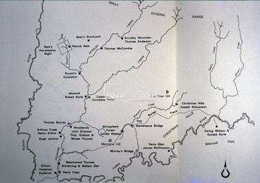
Slide - Photograph, Pastoral Runs, Diamond Creek Catchment, c.Sep. 1989
Part of a slide show presentation "Bridges & Waterways of the Shire" by Russell Yeoman to the 13 September 1989 Society meeting. The presentation included slides of historic photos from the Shire of Eltham Pioneers collections as well as several recent views.35mm colour positive transparency (1 of 33) Mount - Agfa CS System grey 8 dotsProcess Date Sep 1989diamond creek catchment, map, pastoral runs -
 Eltham District Historical Society Inc
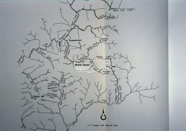
Slide - Photograph, Creeks with Alluvial gold, St Andrews, c.Sep. 1989
Part of a slide show presentation "Bridges & Waterways of the Shire" by Russell Yeoman to the 13 September 1989 Society meeting. The presentation included slides of historic photos from the Shire of Eltham Pioneers collections as well as several recent views.35mm colour positive transparency (1 of 33) Mount - Agfa CS System grey 8 dotsProcess Date Sep 1989map, creeks, alluvial gold, st andrews -
 Eltham District Historical Society Inc
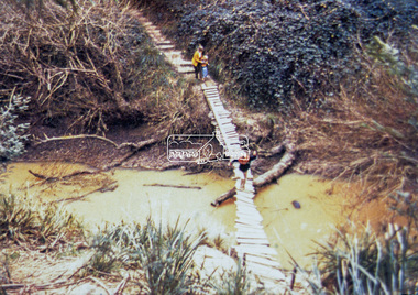
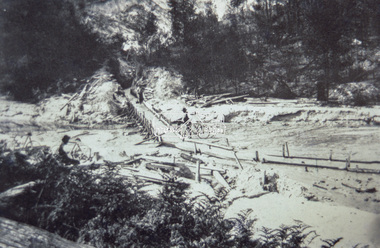
Slide - Photograph, Old footbridge, Gum Glade, Eltham, c.Sep. 1989
Part of a slide show presentation "Bridges & Waterways of the Shire" by Russell Yeoman to the 13 September 1989 Society meeting. The presentation included slides of historic photos from the Shire of Eltham Pioneers collections as well as several recent views.35mm colour positive transparency (1 of 33) Mount - Agfa CS System grey 8 dotsProcess Date Sep 1989old footbridge, gum glade, eltham, diamond creek (creek) -
 Eltham District Historical Society Inc
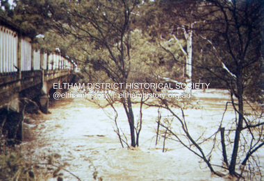
Slide - Photograph, 1934 flood, Eltham South, c.Sep. 1989
Part of a slide show presentation "Bridges & Waterways of the Shire" by Russell Yeoman to the 13 September 1989 Society meeting. The presentation included slides of historic photos from the Shire of Eltham Pioneers collections as well as several recent views.35mm colour positive transparency (1 of 33) Mount - Agfa CS System grey 8 dotsProcess Date Sep 1989eltham, diamond creek (creek), 1934 flood, eltham south, main road bridge -
 Eltham District Historical Society Inc
Slide - Photograph, Sluicing Race, St Andrews, c.Sep. 1989
Part of a slide show presentation "Bridges & Waterways of the Shire" by Russell Yeoman to the 13 September 1989 Society meeting. The presentation included slides of historic photos from the Shire of Eltham Pioneers collections as well as several recent views.35mm colour positive transparency (1 of 33) Mount - Agfa CS System grey 8 dotsProcess Date Sep 1989sluicing race, st andrews -
 Eltham District Historical Society Inc
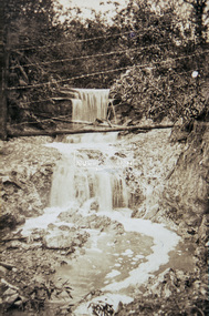
Slide - Photograph, Waterfall, c.Sep. 1989
Part of a slide show presentation "Bridges & Waterways of the Shire" by Russell Yeoman to the 13 September 1989 Society meeting. The presentation included slides of historic photos from the Shire of Eltham Pioneers collections as well as several recent views.35mm colour positive transparency (1 of 33) Mount - Agfa CS System grey 8 dotsProcess Date Sep 1989waterfall