Showing 217 items matching "outbuildings"
-
 Bendigo Historical Society Inc.
Painting - OIL PAINTING BY HARRY CLARKE
Original oil painting, by Harry Clarke of mud brick house & outbuildings near Eaglehawk Golf Course, in a timber frame, signature bottom right corner, with note stuck on rear. Harry Clark lived in Lobb St North Bendigo with his wife and son Max in 1940s. He moved around working for thre mines including Central Deborah (managing or as an inspector). he lived in Alice Springs for a while. He shifted to Wangaratta where he died aged in his 80s. H eloved painting buildings and old houses and landscapes in Central and Goldmines Districts. Information from note attached to painting. Note not signed.Harry Clarkeartwork, oil painting, landscape, victoria-history-eaglehawk -
 Bendigo Historical Society Inc.
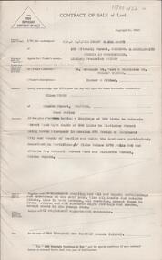
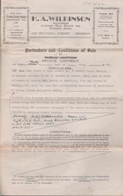
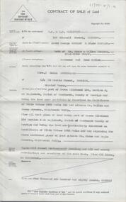
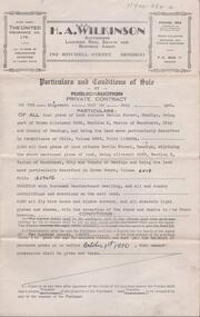
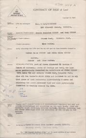
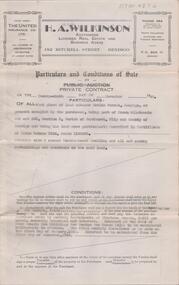
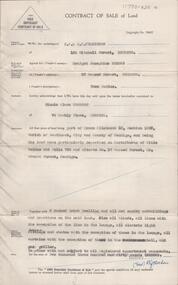
Document - H. A. & S. R. WILKINSON COLLECTION: CONTRACT OF SALE
Conditions of sale by private contract dated 17th July, 1950 between H. Coombes (vendor) and W. & M. L. Seckold (purchaser). Property: land situate No. 57 station Street, Bendigo at present occupied by Mr. R. Boulden as tenant, being part of Crown allotment 8 section 71C, Parish of Sandhurst City of Bendigo, land described in certificate of title volume 6085 folio 1200514, together with 5 room weatherboard dwelling and all sundry outbuildings. Subject to existing weekly tenancy. Price: 600 pounds. Attached letter from solicitors Tatchell, Dunlop, Smalley & Balmer to Mr. Coombes and dated 3rd August, 1950 plus 2 hand written notes.organization, business, h.a. & s.r wilkinson real estate -
 Bendigo Historical Society Inc.
Document - H. A. & S. R. WILKINSON COLLECTION: CONTRACT OF SALE
Conditions of sale by private contract dated 9th June, 1948 between Mrs. E. Howie (vendor) and Mr. L. Thirlwell (purchaser). Property: land situate in Golden Square, having a frontage of approx. 99 feet to Chum Street by a depth of approx. 100 feet, held under residence licence 0588/129, together with 2 roomed wood and cement sheet dwelling and all sundry outbuildings. Price: 160 pounds. Attached letter dated 13th July, 1948 and signed by Mrs. Howie instructing solicitors Williams, Watson& James to pay Messrs. Hume and Iser the sum of 75 pounds, 12 shillings and 3 pence from sale of property.organization, business, h.a. & s.r wilkinson real estate -
 Glen Eira Historical Society
Album - Album page, Booran Road, 30, Circa 1972
... outbuildings ...This photograph is part of the Caulfield Historical Album 1972. This album was created in approximately 1972 as part of a project by the Caulfield Historical Society to assist in identifying buildings worthy of preservation. The album is related to a Survey the Caulfield Historical Society developed in collaboration with the National Trust of Australia (Victoria) and Caulfield City Council to identify historic buildings within the City of Caulfield that warranted the protection of a National Trust Classification. Principal photographer thought to be Trevor Hart, member of Caulfield Historical Society. Most photographs were taken between 1966-1972 with a small number of photographs being older and from unknown sources. All photographs are black and white except where stated, with 386 photographs over 198 pages. From Glen Eira Heritage Management Plan 1996 by Andrew Ward: In 1888, John Leek, a trainer, owned Lot 15, measuring one and three quarter acres, in Booran Road, north side between Glen Eira and Neerim Roads. The land backed onto the Caulfield Racecourse Reserve. NAV was £45. In 1890 Leek built for his residence, a ten roomed brick house on the site. NAV was £200. Leek was the owner/trainer of "Ingliston" who won the Caulfield Cup in 1900. Upon the horse's death in 1901, Leek is understood to have defied tradition by spending £20 on boots for the "ragged urchins in Bourke Street" instead of "shouting" at the bar. By 1899, the property was owned and occupied by Alfred Merrill, a dentist and was known as "Andover". NA V had decreased to £ll0. By 1910, Leslie Macdonald, a gentleman had purchased the property and renamed it "Moidart". In 1910-11 Macdonald sold it to John Robertson. The property had extensive wood stables on its north-east boundary and several other outbuildings. The house continued to be described as "Brick, ten rooms" as it was in 1926 when it was owned and occupied by John Arthur, a managing director. The land measured la.2r.31p. and had a NAV of £235. Nine people lived there. In 1926, Arthur also owned the adjoining Lot 16. Other racehorses of note, known to have been stabled here include Sobar, Havelock, Proud, Future and Lord.Victorian Heritage Register https://vhd.heritagecouncil.vic.gov.au/places/13532 What is significant? Lord Lodge is a thoroughbred racehorse training complex adjacent to Caulfield Racecourse, established in 1890. The area immediately around the racecourse has been associated with horse racing activities and businesses servicing the industry since the development of the racecourse in late the 19th century. Lord Lodge was named by the present occupants after the champion racehorse Lord who was stabled there in the 1950s. In the early 20th century the property was known as 'Andover' and subsequently 'Moidart'. The site consists of a single storey brick Italianate villa, jockeys' quarters, stables and open day yards with direct access to Caulfield racecourse from the rear of the property. The villa of 10 rooms on bluestone foundations was constructed in 1890 by John Leek, a horse trainer who purchased the newly subdivided land in 1888. The house has many Victorian Italianate or Boom Style features although it is more modest than many villas of its style. It has an asymmetrical facade with a faceted bay window and a prominent central tower with low pitch pyramidal roof that provides a clear view of the racecourse. Other characteristic features include stilted segmented arches, bracketed eaves, stucco wall finish and cast cement ornamentation. A room has been added on the north-facing verandah in sympathetic style and finish. Internally the rooms are substantially intact with original marble fireplaces and intricate ceiling roses and cornices. An entrance toward the rear of the southern side of the house is said to be where the stable hands, jockeys and other staff lined up for their meals. In the southeast corner of the property, backing directly on to Caulfield racecourse, is a substantial late Victorian timber stable, probably constructed in the 1890s but first appearing on the property title in 1910. The stable has 12 stalls, a loft and brick pavement and jerkin head roof form with varnished pine-lined ceiling carried on a chamfered timber frame. It has an original roof lantern. The doors of the stalls are not the original sliding doors but swing doors obtained from a barn at Epsom Racecourse in Mordialloc prior to demolition. Outside the gambrel roof has fretted barges but the building is otherwise utilitarian. Timber throughout the stalls has been worn by chewing and rubbing of horses over the century of its use. In the southern half of the property are open day yards where the racehorses are kept during the day. The red brick, single storey jockeys' quarters to the rear of the villa were probably built around 1950. A small brick, possibly late Victorian structure on the eastern boundary thought to have originally been a gardening shed, has been converted to a stable of two stalls. Modern concrete brick stables fill the northeast portion of the property. At the front of the property two Moreton Bay Figs (Ficus macrophylla), probably planted in the late 19th century, provide shade for horses in the day yards. In the 1890s John Leek sold the property, relocating his training facility to one of the newly established racecourses at Mentone or Mordialloc (Epsom). By 1899, the property was owned and occupied by Alfred Merrill, a dentist, who named the property 'Andover'. In 1910 it was purchased by Leslie McDonald, a gentleman, and renamed 'Moidart'; sold in 1910-1911 to John Robertson; and again in 1926 to John Arthur, a racehorse owner. The Victorian Amateur Turf Club purchased the property in the late 1930s and since this time has been leased to racehorse trainers. It is unclear whether the property operated as a training facility between 1899 - 1926. Several notable trainers and jockeys are associated with Lord Lodge. The best known is Arthur 'Scobie' Breasley, Australia's most successful jockey who was apprenticed to trainer Pat Quinlan at Lord Lodge (then 'Moidart') from 1928 - 1935. Breasley rode winners of the Caulfield Cup in four successive years 1942-45 and again in 1952. John Leek, the original owner of Lord Lodge trained Ingliston, the 1900 Caulfield Cup winner. Along with 'Lord' a number of well known racehorses including Sobar, Havelock, Proud and Future were trained at Lord Lodge .....Page 40 of Photograph Album with three landscape photographs of the exterior of this house.Handwritten: 30 Booran Road [top right hand corner] / 40 [bottom right]trevor hart, jenny o'donnell, booran road, mansion, caulfield east, ingliston, sobar, havelock, proud, future, lord, andover, moidart, lord lodge, grace darling, caulfield racecourse reserve, victorian amateur turf club, historic buildings register, national estate register, caulfield cup, horses, stables, horse racing, racehorses, outbuildings, racehorse trainers, depression, 1890s, brick houses, mansions, towers, verandahs, stained glass, italianate style, victorian style, architectural features, architectural styles, john leek, leslie macdonald, john arthur, john robertson, alfred merrill, jenny odonnell -
 Bendigo Historical Society Inc.
Document - H. A. & S. R. WILKINSON COLLECTION: CONTRACT OF SALE
Contract of sale of land dated 11th January, 1956 between Mr. W. S. Bond (vendor) and Mr. R. B. Scott (purchaser). Property: surface and down to a depth of 50 feet below the surface of that piece of land being lot 71 on plan of subdivision lodged in the office of titles No. 16993 being part of Crown allotment 441B section H Parish of Sandhurst city of Bendigo and situate Corner Neale & Burrell Streets, Bendigo, together with brick dwelling, all sundry outbuildings, all floor coverings, all blinds, all electric light fittings and shades, Hoover washing machine, all curtains except those in the 2 front rooms and electric stovette. Price: 3,950 pounds.organization, business, h.a. & s.r wilkinson real estate -
 Bendigo Historical Society Inc.
Document - H. A. & S. R. WILKINSON COLLECTION: CONTRACT OF SALE
Contract of sale of land dated 25th August, 1956 between Mr. A. T. & Mrs. I. M. H. James (vendor) and Mr. J. H. Strange (purchaser). Property: lot 1 on plan of subdivision no. 19491 lodged in the office of titles being part of Crown allotment 24 Parish of Sandhurst County of Bendigo, land described in certificate of title volume 7646 folio 003 and situate Beischer Street, Bendigo, together with 5 roomed weatherboard dwelling, all sundry outbuildings, all floor coverings, blinds, curtains, Metro fridge, "Mettres" electric range, Hoover washing machine and all electric light fittings and shades. Price: 2,780 pounds. Attached 5 hand written notes .organization, business, h.a. & s.r wilkinson real estate -
 Bendigo Historical Society Inc.
Document - H. A. & S. R. WILKINSON COLLECTION: CONTRACT OF SALE
Contract of sale of land dated 20th May, 1954 between Mrs. B. S. Grant (vendor) and Mr. J. C. & Mrs. V. C. Tarr (purchaser). Solicitors for vendor: Noel & Woodward. Solicitor for purchaser: T. M. Williams, Watson & James. Property: that piece of land part of Crown allotment 12 section 19B Parish of Sandhurst City of Bendigo, land described in certificate of title volume 2734 folio 653 and situate No. 30 Shamrock street, Bendigo, together with 5 roomed weatherboard dwelling and all sundry outbuildings, also electric stovette, electric copper, all electric light fittings and shades, rotary clothes line, all blinds and linos. Price: 2,000 pounds.organization, business, h.a. & s.r wilkinson real estate -
 Cheese World Museum
DVD, On our selection: the women's story
This is the story of the women of the bush, women who performed more than the traditional duties of wife and mother. They worked alongside their men, through good/times and bad and they were rare to complain. Six former country women of the Portland/Heywood district provide us with a snapshot of life as it was from the 1920's through to the 1960's. They speak about their own and their mother's lives, lives which have experienced the greatest material and personal changes in history. The story of the 'Remarkable Mary Stuchbery' details the struggles of a wife and family whose husband/father contracted polio shortly after returning from WWII service. Garry Kerr has produced a series of local history stories, initially for the Heywood [history group] and more recent items privately.The material contained in these interviews provides a first-hand insight into the experiences of women who were involved in carving farms from virgin bush. Their recollections of work, social activities and opportunities for their children are an invaluable primary source.Full colour DVD cover featuring image of old hip-roof weatherboard house with front verandah and skillion roof to rear with stone chimney attached to outside. Corrugated iron roof is rusty. To the left is an outbuilding. Picket and wire fencing is in the foreground, background has large cypress tree to left and gum to right. At the bottom is a series of three black and white images showing (L-R) three women in working clothes and a woman holding a baby; woman chopping wood; woman milking cow with young boy standing beside her. The back cover is yellow with images of the seven women featured showing coloured images of the interviewees beside black and white images of the interviewees when young. DVD features the same images as the front cover.Garry Kerr's LOCAL HISTORY Series 5/On Our Selection/The/Women's/Story/Produced by Garry Kerr (front) WOMEN WERE THE UNSUNG HEROES OF THE BUSH/This is the story of the women of the bush [see historical information] ... Running time 74 minutes/Plus an additional 30 minutes of/'The Remarkable Mary Stuchbery' -
 Bendigo Historical Society Inc.
Document - H. A. & S. R. WILKINSON COLLECTION: CONTRACT OF SALE
Contract of sale of land dated 26 March, 1956 between Mrs. I.M. Arthur (vendor) and Mr. W. R. & Mrs. V. L. O'Toole (purchaser). Property: piece of land part of Crown allotment 53 section A at Eaglehawk Parish of Nerring County of Bendigo and being land described in certificate of title volume 4870 folio 850 and situate 65 Peg Leg Road, Eaglehawk. Also all the land adjoining being part of Crown allotment 41 section A Parish of Nerring County of Bendigo land described in certificate f title volume 3198 folio 573, together with 6 room weatherboard and brick dwelling and all sundry outbuildings. Also all floor coverings, blinds, curtains and electric light fittings and shades. Price: 1,275 pounds.organization, business, h.a. & s.r wilkinson real estate -
 Bendigo Historical Society Inc.
Document - H. A. & S. R. WILKINSON COLLECTION: CONTRACT OF SALE
Contract of sale of land dated 28th April, 1956 between Mr. L. F. Bright (vendor) and Mrs. E. Tyack (purchaser). Property: land having a frontage of 125 links to McKenzie street West by a depth of 392 links to Mistletoe Street being Crown allotment 10 section 578 Parish of Sandhurst City of Bendigo being land described in certificate of title volume 5975 folio 905 and situate corner McKenzie Street West and Mistletoe Street, Golden Square, together with weatherboard dwelling and all sundry outbuilding, also all inside and outside blinds, lino in backroom, all curtains, except those in the front bedroom and all electric light fittings and shades escept shade in lounge room. Price 1,100 pounds.organization, business, h.a. & s.r wilkinson real estate -
 Bendigo Historical Society Inc.
Document - H. A. & S. R. WILKINSON COLLECTION: CONTRACT OF SALE
Conditions of sale by private contract dated 9 July, 1946 between Mr. J. W. W. + Mr. H. S. P. + Ms. A. A. Challenger executors of estate of E. Challenger (vendor) and Mr. A. R. Thomson (purchaser). Property: land situate No. 70 Barkly Place, Bendigo at present occupied by Mr. C. Thomson as tenant, being part of Crown allotment 4 section 33C Parish of Sandhurst City of Bendigo, land described in certificate of title volume 4751 folio 950016 - Secondly land being part of Crown allotment 14 section 33C described in certificate of title 3547 folio 709284, together with 6 roomed brick and weatherboard dwelling, all sundry outbuildings except those belonging to the tenant. Subject to existing weekly tenancy. Price: 840 pounds.organization, business, h.a. & s.r wilkinson real estate -
 Bendigo Historical Society Inc.
Document - H. A. & S. R. WILKINSON COLLECTION: CONTRACT OF SALE
Contract of sale of land dated 12th August, 1954 between Mr. D. G. & Mrs. E. Sumbler (vendor) and Mrs. H. Sutherland (purchaser). Property: land being part of Crown allotment 150 section M at Eaglehawk, Parish of Sandhurst, City of Bendigo, land described in certificate of title volume 5922 folio 213 and situate corner Wallen and Stone Streets, California Gully. Also all that piece of land being part of Crown allotment 150 section M at Eaglehawk, Parish of Sandhurst City of Bendigo, land described in certificate of title volume 1092 folio 240 and adjoining the above mentioned land situate corner Stone and eagle Streets, California Gully, together with 5 roomed weatherboard dwelling, all sundry outbuildings and all linos. Price: 1,680 pounds.organization, business, h.a. & s.r wilkinson real estate -
 Bendigo Historical Society Inc.
Document - H. A. & S. R. WILKINSON COLLECTION: CONTRACT OF SALE
Conditions of sale by private contract dated 19th July, 1950 between R. C. Orde (vendor) and H. J. & M. E. Stephenson (purchaser). Property: all that piece of land situate in Havlin Street, Bendigo being part of Crown allotment 326A section H, Parish of Sandhurst City of Bendigo, land described in certificate of title volume 5965 folio 1192804. Also all that piece of land situate in Havlin street adjoining the above mentioned land being allotment 326C section H land described in crown Grant volume 6018 folio 1293456, together with 5 room weatherboard dwelling and all sundry outbuildings, all fly wire doors, window screens, electric light globes and shades, with exception of the shade and chains in the front bedroom. Price: 2,585 pounds.organization, business, h.a. & s.r wilkinson real estate -
 Bendigo Historical Society Inc.
Document - H. A. & S. R. WILKINSON COLLECTION: CONTRACT OF SALE
Contract of sale of land dated 29th April, 1957 between Miss M. J Schier & Mrs. M. Turner (vendor) and Mr. W. J. & Mrs. E. O. Sutton (purchaser). Property: land being part of Crown allotment 23 section G Parish of Mandurang county of Bendigo, land described in certificate of title volume 7374 folio 714 and situated Crusoe Road, Kangaroo Flat. Also all vendor's right title and interest in to that piece of land containing approx. 6 acres and adjoining the above mentioned land described in grazing licence no. 0349. Together with 6 roomed brick and weatherboard dwelling, all sundry outbuildings, electric light fittings, kitchen cabinet, blinds, curtains and floor coverings with exception of the carpet in the lounge. Price: 3,500 pounds. Attached Statement pursuant to section 34 of the estate agents' act 1956.organization, business, h.a. & s.r wilkinson real estate -
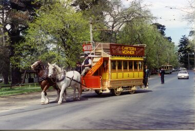 Ballarat Tramway Museum
Functional Object - Tramcar, Duncan and Fraser and Ballarat Tramway Preservation Society, Horse Tram No 1, 1887 - original, reconstruction 1986-1992
A double deck horse drawn tram with single saloon. drop ends, stairs, longitudinal seats, sliding doors, wheels of cast iron, hand brakes - see notes. Originally built by Duncan & Fraser in 1887. Rebuilt by BTPS 1991. From the BTM Fleet page on the website: Built in 1887 by Duncan and Fraser for the Ballaarat Tramway Company Ltd. as a double-decked horse tramcar. One of eight cars which ran as trailers behind electric trams at times of heavy patronage, after takeover and conversion of the horse lines by the Electric Supply Company of Victoria Ltd. in 1905. Withdrawn in the late 1920's when the body shell became a residential outbuilding locally, until retrieved in 1985. Fully reconstructed to its original form and placed on a modified Melbourne saloon cable car truck. See attached notestrams, horse trams, tram 1 -
 Bendigo Historical Society Inc.
Document - H. A. & S. R. WILKINSON COLLECTION: CONTRACT OF SALE
Conditions of sale by private contract dated 29th November, 1949 between E. G. S. Rasmussen (vendor) and E. Simmons (purchaser). Property: land situate Havlin Street, Bendigo at present occupied by the purchaser, being part of Crown allotments 392 and 393 section H, Parish of Sandhurst City of Bendigo, land described in certificate of title volume 5514 folio 1102695, together with 5 room weatherboard dwelling and all sundry outbuildings. Price 1,200 pounds. Attached 4 hand written notes plus 1 letter dated 29th November, 1949 and signed by Mr. Rasmussen detailing the payment to Mr. Simmons the sum of 300 pounds on 10th January, 1950 and a further 100 pounds on 25th February, 1950. Also a letter dated 29th November, 1949 signed by Mr. Simmons acknowledging receipt of the sum of 400 pounds being part of a loan.organization, business, h.a. & s.r wilkinson real estate -
 Bendigo Historical Society Inc.
Document - H. A. & S. R. WILKINSON COLLECTION: CONTRACT OF SALE
Contract of sale of land dated 15th December, 1955 between Mrs. B. J. Meehan (vendor) and Mrs. M. C. Thomson (purchaser). Property: that piece of land being part of Crown allotment 12 section 125C Parish of Sandhurst City of Bendigo, land being described in certificate of title volume 084 folio 756 and situate No. 37 Garsed Street Corner Edward Street, Bendigo, together with 6 roomed brick dwelling and all sundry outbuildings, also all blinds, all linos with the exception of lino in the lounge, all electric light fittings and shades with the exception of those in the hall and gas griller. Price: 2,300 pounds. Attached 2 copies of letter signed by Mrs. B. J. Meehan giving Mrs. Thomson the option to purchase the property for the sum of 2,350 pounds until 6PM Wednesday 14th December, 1995, the letter is dated 12th December, 1955.organization, business, h.a. & s.r wilkinson real estate -
 Bendigo Historical Society Inc.
Document - Samson's Cottage Significance Assessment, 1967
The first, two-roomed, stage of the present cottage appears to have been commenced before 1866, when the first rate notice appeared (Shire of Marong) and possibly as early as the mid-1850s, when the first owner, Thomas Samson, a shoemaker turned joiner, came to the Bendigo goldfields. Samson took up a miner's right in Spec(k) Gully in the mid-1850s. The Samson family had ten children and as the family grew they extended the cottage in stages. Samson worked as a miner until about 1871, then returned to boot making from a weatherboard shed on the property. He opened a shop on the corner of Booth and McKenzie Streets in partnership with John Shocker in 1889. He died in 1893. His wife Sarah remained in the cottage until 1906. Albert and Florence Doye purchased the site in 1908 and the family lived there until 1966. The property has remained in the hands of the family, mostly unoccupied. It was renovated by a tenant in the 1970s and passed from miner's right to freehold in 1974. It is currently owned by Arthur Doye, who lives nearby, and is unoccupied. During its early life it, probably during the Samson occupation, it was altered and extended many times into a complex arrangement of structures and outbuildings. Stone remained the dominant building material throughout, even for the poultry shedsThree page report on the significance of Sansom's Cottage, 21 Doye Street, Golden Square, Bendigo. Topics include what is significant; why is it significant; permit exemptions; assessment against criteria; extent of registration and contextual history. Final page on 'history of place' is missing from document.sansom cottage, golden square, heritage register, sandstone, miner, shoemaker, thomas sansom -
 Wodonga & District Historical Society Inc
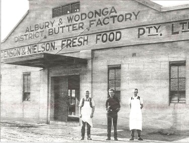
Photograph - Albury & Wodonga District Butter Factory
Holdenson and Nielson Fresh Food Pty Ltd was founded in 1903 by Poul Jorgenson Holdenson and Andrew Nielson, after acquiring the Fresh Food and Storage Co, which had plants throughout Australia, including Albury. The plant was moved to Wodonga that year. Cream was collected from all areas of North East Victoria and the Riverina, with contractors carting it to the railway stations for rail travel to Wodonga. The Butter Factory was built on the Lincoln Causeway in 1926, and the Cheese Factory in 1942 as a wartime emergency project. At the same time, a pasteurising plant was installed in the complex, and so whole milk was collected from dairy farmers, rather than just cream. The company was bought out by the North Eastern Dairy Co-operative in 1962. It became a retail milk depot also involved in ice-making and cold storage. In 1985, Goulburn Murray bought the complex and as the site was surplus to requirements, it was sold to Wodonga Council. The buildings were adapted for other uses. The Butter Factory was modified and extended and for some time was occupied by the Albury- Wodonga Visitor Centre. The Creator's Gallery was established in the engine room, and the loading area and ice-making works were extended and modified for use as the HotHouse Theatre. The Cheese Factory was adapted for use as a theatre and jazz venue, and housed the HotHouse office. The various outbuildings, such as garages and storage areas, were adapted for use as shops and craft outlets.This collection is significant because it documents an important industry in Wodonga.A collection of images and advertisements promoting Holdenson and Nielsen of Wodongaholdenson & nielson, wodonga dairies, victorian dairy industry -
 Whitehorse Historical Society Inc.
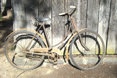
Vehicle - Bicycle
In 1914, Mr and Mrs Arthur Hooke gave the name ‘Wandinong’ to their newly purchased property in Blackburn. The name was inspired by a recent cycling trip to Wandin in the foothills of the Dandenongs, as well as the title of a favourite book, Ethel Turner’s ‘The Camp at Wandinong’. Their property and the surrounding district had originally been owned by a series of property investors and speculators, and while some of it had been cleared for grazing, most of it was still covered in virgin bush; thickly covered with trees and undergrowth and rich in wild flowers and bird life. A small section of the Hooke’s property was cleared sufficiently to r\erect a house and some outbuildings, but the rest was left as n nature intended. Mar Arthur Hooke was a local property valuer but never owned a car, preferring to attend to business on his bicycle. He was still riding his bicycle in his eighties. Meanwhile, Mrs Hooke had developed a keen desire that the ‘Wandinong’ property remain intact; that it should ultimately be set aside as a place of refuge where like-minded people could go to enjoy peace and quiet amongst the native birds and bushland.|To this end, Mr and Mrs Hooke liaised with the Nunawading Council and an agreement was reached whereby the council would assume ownership of the property on their deaths. When Mr Hooke died in 1972, his wife transferred the land over to the council the following year. Mr and Mrs Arthur Hooke’s Grandson, William, and granddaughter, Christine, recently donated their grandmother’s bicycle to the Whitehorse Historical Society. They recall that their grandfather’s bicycle was given to a representative of the Nunawading Council for safekeeping some years ago. Ladies two wheel bicycle with tool bag attached & black leather seat. Two mud guards, a skirt guard & a reflector on the back mud guard. 'Kew Flyer' painted on front mud guard. Two rubber tyres & provision for a head light on the handle bars.'Kew Flyer'transport, bicycles -
 Tarnagulla History Archive
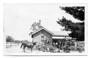
Photograph of Comrie family in Tarnagulla, Comrie family in Tarnagulla, 31st January 1924
Murray Comrie Collection. The house in this photo was the residence of the town police officer. The town block where the house was located was the base for policing in Tarnagulla from 1878 until the 1990s. At the time of this photo (1924), the father of these children, Angus Comrie Snr was the constable for Tarnagulla. Adjacent to this house was a lockup, office and stable (shown in THA-2019.0031). Behind the residence and outbuildings (in background of this photo) was an adjoining paddock for the police horses. This house was sold for removal in in the 1960s and replaced with a prefabricated residence and small office from Bealiba. These as well as the lockup are still in place (as of 2019), but are no longer used. There are now private residences built on the former police horse paddock. A later image of this house is THA-2019.0032. For almost 100 years the Comrie name has been involved with the Victoria Police. Angus Comrie Snr, joined the force in 1899 and served as constable in Kaniva and Avoca and then in Tarnagulla from late 1909 until 1927. His son Murray Comrie, born in Tarnagulla in 1912 also became a policeman and later a Chief Superintendent, retiring in 1972 and passing away in 1983 after a long illness. Murray Comrie's son Murray Jnr., to avoid confusion became known by his middle name, Neil. Neil Comrie also joined Victoria Police and rose through the ranks to become Chief Commissioner of Victoria Police from 1993 to 2001. The Murray Comrie Collection held by Tarnagulla History Archive was collated in the 1970s by Murray Comrie (1912-1983). Sepia photographic postcard, image depicting members of the Comrie family outside their home in Tarnagulla. According to the note on reverse, the subjects are as follows: On the verandah (left to right) are Murray Comrie, 'Mother' (Mary Ellen Comrie), and Keith Comrie. Angus Comrie Jr. is holding a roped mare. Standing at centre are 'Hilda' and 'Roy' (small child). See second image for handwritten notes on reverse.tarnagulla, police, policing, comrie -
 Bacchus Marsh & District Historical Society
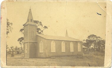
Photograph, Trinity Church Bacchus Marsh (The Iron Church)
Anglican (Church of England) services began in Bacchus Marsh as early as the 1840s. In 1855 an imported iron building from England became the first permanent Anglican Church building in Bacchus Marsh. It stood close to the location of the Holy Trinity Anglican Church erected in 1877 which still stands in 2025. It was in use between 1855 and 1877. These type of iron structures were cheaper to erect and could be dismantled and moved to other locations when necessary. The Iron Church was brick-lined and could hold between 150 and 200 people. The Church was opened on 4 July 1855 by Hussey Burgh Macartney, Dean of Melbourne. It was later consecrated by Bishop Perry on 28 July, 1861. The cost of construction was around 1,000 pounds. In 1877 the Holy Trinity Church was erected. The Iron Church was dismantled and sold to to two local businessmen, George Marshall and James Reid. It was re-erected in July 1877 without its brick lining or steeple and is presumed to have been used as a shed at a location in Graham Street known as 'Webster's Brothers Yard', (14 Graham Street). Over time the structure deteriorated to the point that it could no longer be used. Remnants of the Iron Church could be seen for many years. In 1995 the remnants were described by Peterson and Catrice in the Heritage Study of Bacchus Marsh Shire in the this way, 'on the rear boundary, now used as an outbuilding, is the surviving fabric of the former "Iron Church". This has a gabled roof and had four pointed windows at sides. It is all clad in corrugated iron. Access was not possible, but a 1977 photograph shows Gothic tracery in a window'. This is a rare image of a prefabricated building in mid-nineteenth century Victoria. Prefabricated buildings were widely used in the early Colonial period of Victoria as a cheaper building option for new and developing communities. Most of these buildings did not survive in the long term and photographic evidence of these type of structures is an important record of an aspect of Victoria's architectural history.Small black and white 'carte de viste' style photograph mounted on card. The image depicts the first permanent Anglican Church building in Bacchus Marsh, the Trinity Church, also known as the Iron Church. The date of the image is thought to be about 1867.anglican church bacchus marsh, churches bacchus marsh, trinity church bacchus marsh, bacchus marsh iron church, prefabricated buildings -
Port Melbourne Historical & Preservation Society
Photograph - Various photos related to John James GILCHRIST, John Gilcrist, 1940s - 1950s
From John Gilcrist via Janet Bolitho13 photos from John GILCHRIST showing his father, John James GILCHRIST, at Station Pier and Princes Pier, a view from the Shrine of Remembrance, Centenary Bridge, and his father and mother, Eileen Mary GILCHRIST at their home at 16 McCormack Street Port Melbourne .01 - Princes Pier, Taroona, Port Hobart .02 - View from Shrine overlooking Albert Park Lake .03 - Between piers .04 - Princes Pier at night .05 - From Station Pier West finger pier .06 - House at 16 McCormack Street. (No. 12 McCormack Street also shown) .07 - Centenary Bridge1949-50 .08 - Outside 16 McCormack Street, showing Singer car. (Nos. 22, 24 & 26 McCormack Street also shown) .09 - John and Eileen Gilcrist in backyard .10 - South side of house at 16 McCormack Street .11 - South side of house at 16 McCormack Street .12 - Photo of Edwards Park .13 - East side of house at 16 McCormack Street Refer also to hand drawn plan of house and outbuildings at catalogue no. 2763piers and wharves - station pier, piers and wharves - princes pier, built environment, transport - roads, mccormack street, john gilchrist, john james gilchrist, mary eileen gilchrist -
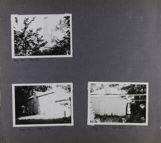 Glen Eira Historical Society
Album - Album page, Rose Craddock, Rose Craddock Avenue, Circa 1972
... outbuildings ...This photograph is part of the Caulfield Historical Album 1972. This album was created in approximately 1972 as part of a project by the Caulfield Historical Society to assist in identifying buildings worthy of preservation. The album is related to a Survey the Caulfield Historical Society developed in collaboration with the National Trust of Australia (Victoria) and Caulfield City Council to identify historic buildings within the City of Caulfield that warranted the protection of a National Trust Classification. Principal photographer thought to be Trevor Hart, member of Caulfield Historical Society. Most photographs were taken between 1966-1972 with a small number of photographs being older and from unknown sources. All photographs are black and white except where stated, with 386 photographs over 198 pages. From Victorian Heritage Database citation for Rosecraddock https://vhd.heritagecouncil.vic.gov.au/places/35279 as at (30/10/2020) City of Glen Eira Heritage Listing HO16 "Rosecraddock" is regionally important as a surviving large villa from the early Victorian (1850's) period, offering insight into the lifestyles of the privileged in Caulfield at that time. Its importance is enhanced through its long association with the Langdon family and, in particular, Henry Joseph Langdon, founder of H.J. Langdon and Company, China merchants.There is a separate statement of significance at https://vhd.heritagecouncil.vic.gov.au/places/277 for H0589 Rosecraddock 2-8 KEVERELL ROAD and 4-10 CRADDOCK AVENUE CAULFIELD NORTH - Victorian Heritage RegisterPage 175 of Photograph Album with three photographs of Rose Craddock.Handwritten: Neg 190 Nov 1972 [under top left photo] / Neg 207 Nov 1972 [under bottom left photo] / Neg 191 Nov 1972 [under bottom right photo] / 175 [bottom left]trevor hart, chimneys, porch, rose craddock, rosecraddock, 1850's, henry joseph langdon, h.j. langdon, h.j. langdon and company, china merchants, rosecraddock place, slate roof, return verandah, decorative brackets, cast iron lacework, keverell road, caulfield north, early victorian style, mansions, protruding bay windows, cast iron work, outbuildings, craddock avenue, gardens -
Clunes Museum
Painting - PAINTINGS, David Williams
Images of; Horse Trough & Wagon Residence 94 Bailey Street Former Presbytery St. Thomas Aquinas Former Clunes Free Library Residence 25 Camp Street Monument 100 years of gold Clunes in Melb Monument Former butcher's shop Fraser Street Residence & shops 41-43 Fraser Street Clunes School of Mines Clunes War Memorial Residence 32 Leslie St Clunes Former suspension bridge Former St Paul's Vicarage 42 Service Street Former Police Office Former Police residence Portable Lock Up Former Dow Residence 9 Hill St Former Hall & Fire Station 2 Hill St St Paul's timber Church hall St Paul's Church Masonic Lodge 23 Service St St Paul's Pulpit Masonic Lodge interior Everhard cordial bottles Scythes in Clunes Museum Ascot Blacksmith shop Former Ascot hotel MIA Hall Ascot The Coghill Monument Former Methodist Church Coghills Creek Clunes Cemetery Chapel Maiden Hill Homestead shearing shed Beckworth Court stables Beckworth Cour shearer's quarters Former School Evansford Glengower Outbuilding Amerst Former Mortuary 46-50 Fraser Street Wood fired heater Beckworth court farm shed Gold mine trolley Servant's bells Maiden Hill cow bail Former South Clunes school 29 George Street 70 Fraser Street Former Post Office "Allowah" Clunes Street Ascot "Homestead" Beackwith Court "The Meat House" Beckwith Court "Shearing Sheds" Beckwith Court Evansford Community Hall 54 watercolours remaining from the 2003 exhibition held at Clunes, all unframed, depicting Clunes and surrounds architecture and streetscapes.BY DAVID WILLIAMSwatercolour, 2003 exhibition -
 Eltham District Historical Society Inc
Photograph, Peter Pidgeon, Birch Cottage, Eltham-Yarra Glen Road, Christmas Hills, 27 September 2018, 2018
Originally built by John Hill, a shoemaker at Kangaroo Ground around 1878. In the late 1970s when our Society was the Shire of Eltham Historical Society, an offer was made to the Society regarding use of an old cottage at Christmas Hills. The cottage sat beside Watsons Creek just outside the then Shire of Eltham but following municipal restructuring it now lies within the Shire of Nillumbik. For various reasons the offer ultimately lapsed. At that time some research on the cottage was carried out for the Society by Keith Chappel as part of a larger research project that he was doing. Keith’s notes were taken from Lands Department records and showed that the property was the subject of a permissive occupancy of Crown land comprising the creek reserve. In 1903 a Miner’s Right of one acre in area was granted to Edwin Samuel Birch. In 1907 Birch applied to purchase this land but was unable to because it was part of the creek reserve. The documents show that the cottage existed at that time. Upon Birch’s death in 1932, his daughter, Honor Mary Birch was granted a permit to occupy the residence. Honor Mary Birch, known as Nora, was born 1900, the daughter of Edwin Samuel Birch and Honor (nee Young). In 1939 she married George Henry Williams (aka Henry). Honor died 8 July 1976. Her siblings were Margaret Martin (dec), Bert Birch and Brigidene Brinkkotter. In her will she gave and bequeathed “all the improvements on the land held by me at Christmas Hills under Permissive Occupancy from the Department of Land and Survey consisting of the house property thereon and all the contents of the said house to my nephew Brian Joseph Martin of Christmas Hills aforesaid farmer”. The will described the property as a four room, five square house, about 100 years old with enclosed verandah, including kitchen, combined lounge dining room, bedroom and store room; built of ‘bush slabs’ with a corrugated iron roof. A dairy had been erected in 1935. After her death, the property was acquired by the Melbourne Metropolitan Board of Works in 1978. The property is listed on the Victorian Heritage Database HO200-Hill, later Birch farm complex, 945 Eltham-Yarra Glen Road, Watsons Creek and described as: The house has a steep but simply gabled roof form clad with corrugated iron, vertical adzed hardwood slab front wall construction, split palings to the gable ends; rubble freestone chimney at one end (with added gsi flue), pole-framed Graeme Butler & Associates, 2006: 101 Shire of Nillurnbik Planning Scheme Amendment C13 Heritage Assessments verandah (rebuilt?); six-pane double-hung sash windows; T&G bead-edge boarded ledged & braced door; and paling clad rooms added at verandah ends. A slab-clad large fireplace is at the north corner of the house, with a gsi upper cladding added and an internal lining of rubble stone. The rear facade is different construction, being drop-slab, and sits beneath a rear skillion addition to the main gabled form: this may be more recent construction. The house appears to have been once set up for public display and may have been recreated in part for that purpose. Outbuildings are reached by a track along the east side of the house, including what may have been a creamery (typical standard inter-war design clad with corrugated iron and lined with 1938 Lysaght Queens Head Australia galvanised sheet iron) and a paling clad gabled out-house. Timber outbuildings of differing eras are to the north-west of the house, with pole framing and paling infill construction and Redcliffe brand corrugated iron. Post and rail (front) and split paling (rear) fence remnants line the front boundary. Pepper trees part of house yard landscape49 born digital images (includes one panoramic stitch and nine frames from drone video)birch cottage, christmas hills, early settlers, edwin samuel birch, honor mary birch, john hill, watsons creek -
 Kew Historical Society Inc
Plan, Melbourne & Metropolitan Board of Works : Borough of Kew : Detail Plan No.1568, 1905
The Melbourne and Metropolitan Board of Works (MMBW) plans were produced from the 1890s to the 1950s. They were crucial to the design and development of Melbourne's sewerage and drainage system. The plans, at a scale of 40 feet to 1 inch (1:480), provide a detailed historical record of Melbourne streetscapes and environmental features. Each plan covers one or two street blocks (roughly six streets), showing details of buildings, including garden layouts and ownership boundaries, and features such as laneways, drains, bridges, parks, municipal boundaries and other prominent landmarks as they existed at the time each plan was produced. (Source: State Library of Victoria)This plan forms part of a large group of MMBW plans and maps that was donated to the Society by the Mr Poulter, City Engineer of the City of Kew in 1989. Within this collection, thirty-five hand-coloured plans, backed with linen, are of statewide significance as they include annotations that provide details of construction materials used in buildings in the first decade of the 20th century as well as additional information about land ownership and usage. The copies in the Public Record Office Victoria and the State Library of Victoria are monochrome versions which do not denote building materials so that the maps in this collection are invaluable and unique tools for researchers and heritage consultants. A number of the plans are not held in the collection of the State Library of Victoria so they have the additional attribute of rarity.Original survey plan, issued by the MMBW to a contractor with responsibility for constructing sewers in the area identified on the plan within the Borough of Kew. The plan was at some stage hand-coloured, possibly by the contractor, but more likely by officers working in the Engineering Department of the Borough and later Town, then City of Kew. The hand-coloured sections of buildings on the plan were used to denote masonry or brick constructions (pink), weatherboard constructions (yellow), and public buildings (grey). Plan No.1568 covers the area bounded by Cotham Road, John Street, Sackville Street, and Edward Street. Alfred Street and Rowland Street are in shown in the middle of the plan. The two most notable buildings shown are ‘St Helliers’, the home of the Dumaresq family, and St Hilary’s Church and school. While the colours used to indicate St Hilary’s are grey as in other civic/public buildings, the first St Hilary’s Anglican Church was at this stage constructed in weatherboard. At the left of the plan, facing Sackville Street is a house named ‘Glencara’. The 1988 ‘Kew Conservation Study’ recorded that “The first documentary evidence of this house comes from Rate Books which record that in 1893 a Mrs Treadway was the owner of this building with an N.A.V. of £81? At that date the occupier of the house was Charles B. Kelly, a clerk, while by 1910 Kelly had become the owner of the property described in that year ‘as a six-roomed stone, brick and wood house with stables and outbuildings’”. Contrary to this description, the 1905 plan indicates that the house was entirely constructed of masonry.melbourne and metropolitan board of works, detail plans, mmbw 1568 -
 Warrnambool and District Historical Society Inc.
Photo, Negatives Pioneers of Warrnambool & District board, 1975
The following extract written by Karen Tyers Warrnambool Family history group explains the journey and background of the Warrnambool Pioneer Board. Warrnambool is fortunate to have a photographic record of some of its pioneers. They are commemorated on the Pioneers’ Board. The Pioneers’ Board with its elaborate frame measures approximately 2 metres by 3 metres and holds 204 photographs of Warrnambool’s early pioneers. In 1907 Edward Vidler, secretary of the Warrnambool & District Progress League and Chamber of Commerce and Industry, invited descendants of those who arrived in Warrnambool before 1860 to send photographs of their pioneer ancestors to commemorate the Diamond Jubilee of Warrnambool’s foundation in 1847. A charge of £1 for each photograph was set. Lillian Foyle of Foyle’s photographic studio, was engaged to colour the photographs and undertake the associated artwork. By December 1907 the honour board was on exhibition in Bernard’s Gallery, Melbourne. Unfortunately Vidler left Warrnambool in 1907 with the honour board expenses unpaid. The Progress League refused to take responsibility for the debt and the honour board remained with Foyle’s Studio for 17 years. In 1922 subscriptions were called for and £43 16s 6d was acknowledged. After a final determined effort was made in 1924, the £100 debt was collected and Charles Foyle, Lillian’s brother, accepted settlement of the debt. On 2 May 1924 the honour board was moved from Foyle’s Studio to the Art Gallery. For many years the honour board was in the entrance passage to the public library. After the library was demolished in 1975 the pictures were removed to the Art Gallery where it was restored by the Director of the Art Gallery, Jack Welsh. The board was later stored in an empty front room at Murweh and the dismantled frame stored in an outbuilding. By 1982 the honour board was in the foyer of the City Council offices. During the renovations of the interior of the council offices in 1997 the honour board was moved to the library where it remained until moved to HeritageWorks in March 2014. For a full list of names go to http://www.warrnamboolhistory.org.au/warrnambool-history/pioneers-board/ The Warrnambool pioneer Board is one of those rare items which can claim significance on most if not all of the primary and comparative significance criteria. As a collection of early pioneers in the district it provides a valuable resource for historians and researchers. It gives light to a social scene in the district much of which can be verified from diaries and other items held by the historical society and also available on websites such as Trove. It has relevance to this day with many family historians enquiring of people included on the board. The collation of the board is a story of great interest in itself. While there are images of 204 men on the board the only reference to a woman is Lillian Foyle the artist who was responsible for much of the artistic work on the board. It compares well in size and quality with a number of montages, and collations of images from around the state of Victoria. It is by no means a complete list of pioneers of the district but there are many well- known ones included. They come from a wide range of backgrounds and as such presents a cross section of our earliest settlers in the district from 1840's to 1860’s.Cardboard folder with black and grey mottled cover with 3 metal studs along spine and white paper label with the word negative printed in black on front cover. Inside is a printed index of pioneers with reference relating to board number and negative number. There are three loose strips of negatives and 20 pages with pockets to hold strips of negatives. Up to page 13 have negatives strips inserted. There are 15 large and one small print of some of the pioneers from the board.This negative album was prepared by John A Welsh MBE JP Dip M Eng Director Warrnambool Art Gallery 1/7/1975 to 11/12/1977.There are a number of grey lead notations possibly corrections against some of the names in the index.warrnambool, warrnambool pioneer board, jack welsh, warrnambool art gallery, pioneers of warrnambool, foyles photography, lillian foyle, bernard framers, w mcaree, -
 Glen Eira Historical Society
Album - Album page, "Ripponlea", Hotham Street, Circa 1972
... outbuildings ...This photograph is part of the Caulfield Historical Album 1972. This album was created in approximately 1972 as part of a project by the Caulfield Historical Society to assist in identifying buildings worthy of preservation. The album is related to a Survey the Caulfield Historical Society developed in collaboration with the National Trust of Australia (Victoria) and Caulfield City Council to identify historic buildings within the City of Caulfield that warranted the protection of a National Trust Classification. Principal photographer thought to be Trevor Hart, member of Caulfield Historical Society. Most photographs were taken between 1966-1972 with a small number of photographs being older and from unknown sources. All photographs are black and white except where stated, with 386 photographs over 198 pages.From Victorian Heritage Database citation for Rippon Lea H0614 https://vhd.heritagecouncil.vic.gov.au/places/427(as at 23/10/2020) Rippon Lea was commenced in 1868 by Frederick Sargood, a most successful politician and merchant. He was born in England in 1834 and arrived in Melbourne in 1850. He soon joined his father's wholesale soft goods firm, spending some time as its manager on the goldfields. Sargood entered the Legislative Council in 1874. He was Victoria?s first Minister for Defence in 1883. Sir Frederick Sargood was created CMG. In 1885 and KCMG in 1890 as a reward for his contribution to public life. He died suddenly in 1903. Rippon Lea was designed by the leading firm of architects, Reed and Barnes. Joseph Reed had travelled in Europe in 1863, including northern Italy. When he returned he introduced the use of polychromy. While not the first examples, Rippon Lea and the Independent Church in Collins Street were the best and set a fashion which became a distinctly Melbourne style, particularly used for houses and churches. Its popularity was possible because of the new availability of different coloured bricks. Reed's fine Lombardic Romanesque details soon became debased by others. As Sargood's family grew and his fortunes prospered, Rippon Lea was extended to include 33 rooms - a complete mansion. The cast iron porte cochere and the northern conservatory were added in 1897. The architects were Taylor and Fitts. The ballroom was added in 1882 and remodelled in 1889. Many alterations have changed the interior and exterior during the ownerships of Benjamin Nathan and later his daughter Mrs Louisa Jones in the 1930s and are in their own right of significance. Sir Thomas Bent owned the property from 1903 until 1911 but never lived there. He subdivided much of the land. The original garden dates from about 1868, and it seems that William Guilfoyle of the Botanic Gardens was involved. It was redesigned in a more natural style in the 1880s by Sargood and his head gardener, Adam Anderson. The lake, waterfalls, fernery, hill and grotto are balanced by mighty deciduous trees and conifers. These are interspersed with, but never dominated by Australian species such as eucalyptus and other exotics. The sinuous drive with its carefully prepared approach to the house is notable. The original vegetable gardens, orchard and outer paddocks no longer survive. The shade house is important as the largest known in Australia and possibly the world. Its curved plan and form of construction are particularly notable. It was built about 1884.Page 94 of Photograph Album with four photographs (three landscape and one portrait) of Ripponlea - stables, lookout and neighbouring cottages.Handwritten: "Ripponlea" Hotham Street [top right] / Neg 256 Dec 1972 STABLES [under top left photo] / Neg 248 Dec 1972 LOOKOUT [under top right photo] / Neg 254 Dec 1972 / COTTAGES WILLOW STREET [under bottom left photo] / Neg 259 Dec 1972 STABLES [under bottom right photo] / 94 [bottom right]trevor hart, elsternwick, mansion, hotham street, frederick sargood, reed and barnes, 1860's, 1890's, 1880's, benjamin nathan, nathan, louisa jones, thomas bent, sir thomas bent, william guilfoyle, guilfoyle, adam anderson, ripponlea, victorian, sir frederick sargood, architects, bricks, polychrome bricks, taylor and fitts, stables, lookouts, cottages, outbuildings, rippon lea -
 Eltham District Historical Society Inc
Photograph - Digital Photograph, Marguerite Marshall, Stuchbery Farm dairy, 14 March 2008
Stuchbery Farm was situated on the Plenty River bounded by Smugglers Gully to the north and La trobe Road, Yarrambat, to the east. Alan and Ada Stutchbery moved to the valley in 1890, first living in a tent where four children were born. Alfred built a home and outbuildings around 1896. They planted an orchard, then a market garden and developed a dairy. Published: Nillumbik Now and Then / Marguerite Marshall 2008; photographs Alan King with Marguerite Marshall.; p179 The dramatic steep-sided Plenty Gorge lies along the divide of two geological areas, and separates the Nillumbik Shire and the City of Whittlesea. On the Nillumbik side are undulating hills and sedimentary rock, and in Whittlesea, lies a basalt plain formed by volcanic action up to two million years ago. This provides the Plenty Gorge Park with diverse vegetation and habitats, making it one of Greater Melbourne’s most important refuges for threatened and significant species. The park, established in 1986, consists of around 1350 hectares, and extends 11 kilometres along the Plenty River, from Greensborough to Mernda. It provides a wildlife corridor for around 500 native plant and 280 animal species. The area’s plentiful food and water attracted the Wurundjeri Aboriginal people and then European settlers. By 1837 squatters had claimed large runs of land for their sheep and cattle. The Plenty Valley was among the first in the Port Phillip District to be settled - mainly in the less heavily timbered west - and was proclaimed a settled district in 1841. But by the late 1880s, the settlers’ extensive land clearing for animal grazing, then agriculture, depleted the Wurundjeri’s traditional food sources, which helped to drive them away. Many Wurundjeri artefacts remain (now government protected), and so far 57 sites have been identified in the park, including scarred trees, burial areas and stone artefacts. Pioneer life could be very hard because of isolation, flooding, bushfires and bushrangers. Following the Black Thursday bushfires of 1851, basalt was quarried to build more fire-resistant homes. Gold discoveries in the early 1850s swelled the population, particularly around Smugglers Gully; but food production made more of an impact. In the late 1850s wheat production supplanted grazing. In the 1860s the government made small holdings available to poorer settlers. These had the greatest effect on the district, particularly in Doreen and Yarrambat, where orchards were established from the 1880s to 1914. Links with a prominent early family are the remains of Stuchbery Farm, by the river’s edge bounded by Smugglers Gully to the north and La Trobe Road, Yarrambat, to the east. The Stuchberys moved to the valley in 1890, and the family still lives in the area. In 1890, Alfred and Ada first lived in a tent where four children were born, then Alfred built the house and outbuildings around 1896. They planted an orchard, then a market garden, and developed a dairy. The family belonged to the local Methodist and tennis communities. Their grandson Walter, opened the Flying Scotsman Model Railway Museum in Yarrambat, which his widow, Vi, continues to run. Wal was also the Yarrambat CFA Captain for 22 years until 1987. Walter sold 24 hectares in 1976 for development - now Vista Court - and in 1990, the remaining 22.6 hectares for the park. Remaining are an early stone dairy and remnants of a stone barn, a pig sty and a well. Until it was destroyed by fire in 2003, a slab hut stood on the Happy Hollow Farm site, at the southern end of the park. The hut is thought to have been built in the Depression around 1893. This was a rare and late example of a slab hut with a domestic orchard close to Melbourne. Emmet Watmough and his family first occupied the hut, followed by a succession of families, until the Bell family bought it around 1948. There they led a subsistence lifestyle for 50 years, despite encroaching Melbourne suburbia. The Yellow Gum Recreation Area includes the Blue Lake, coloured turquoise at certain times of the year. Following the 1957 bushfires, this area was quarried by Reid Quarries Pty Ltd for Melbourne’s first skyscrapers, then by Boral Australia. However in the early 1970s water began seeping into the quarry forming the Blue Lake and the quarry was closed. The State Government bought the site in 1997 and opened it as a park in 1999.This collection of almost 130 photos about places and people within the Shire of Nillumbik, an urban and rural municipality in Melbourne's north, contributes to an understanding of the history of the Shire. Published in 2008 immediately prior to the Black Saturday bushfires of February 7, 2009, it documents sites that were impacted, and in some cases destroyed by the fires. It includes photographs taken especially for the publication, creating a unique time capsule representing the Shire in the early 21st century. It remains the most recent comprehenesive publication devoted to the Shire's history connecting local residents to the past. nillumbik now and then (marshall-king) collection, ada stuchbery, alan stuchbery, dairy, stuchbery farm, farm buildings, yarrambat, plenty gorge park