Showing 836 items
matching parish map
-
 Bendigo Historical Society Inc.
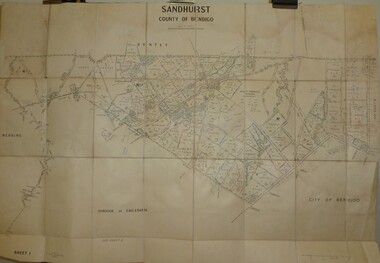
Map - JACK FLYNN COLLECTION: SANDHURST SHEET 6, January 1947
... Map: Parish of Sandhurst Sheet 6. County of Bendigo. Parish..., of Lands and Survey, Melbourne, Victoria. Map: Parish of Sandhurst ...Map: Parish of Sandhurst Sheet 6. County of Bendigo. Parish plan.By Authority J. J. Gourley, Government Printer, Melbourne. Drawn and Reproduced at the Dept, of Lands and Survey, Melbourne, Victoria.map, bendigo, parish plan, sandhurst sheet 6 -
 Bendigo Historical Society Inc.
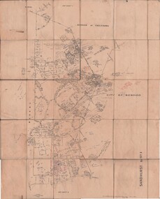
Map - JACK FLYNN COLLECTION: SANDHURST SHEET 2, January 1947
... Map: Parish of Sandhurst Sheet 2, County of Bendigo. Parish..., of Lands and Survey, Melbourne, Victoria. Map: Parish of Sandhurst ...Map: Parish of Sandhurst Sheet 2, County of Bendigo. Parish plan.By Authority J. J. Gourley, Government Printer, Melbourne. Drawn and Reproduced at the Dept, of Lands and Survey, Melbourne, Victoria.map, bendigo, parish plan, sandhurst sheet 2 -
 Bendigo Historical Society Inc.
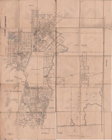
Map - JACK FLYNN COLLECTION: SANDHURST SHEET 1, January 1947
... Map: Parish of Sandhurst sheet 1, County of Bendigo. Parish... Bendigo parish plan Sandhurst Map: Parish of Sandhurst sheet 1 ...Map: Parish of Sandhurst sheet 1, County of Bendigo. Parish plan.map, bendigo, parish plan, sandhurst -
 Bendigo Historical Society Inc.
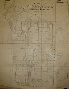
Map - JACK FLYNN COLLECTION: MOLIAGUL, October 1946
... Map: Parish of Moliagul, Sheet 1, County of Gladstone... Gladstone parish plan Moliagul Map: Parish of Moliagul, Sheet 1 ...Map: Parish of Moliagul, Sheet 1, County of Gladstone. Parish plan.map, gladstone, parish plan, moliagul -
 Bendigo Historical Society Inc.
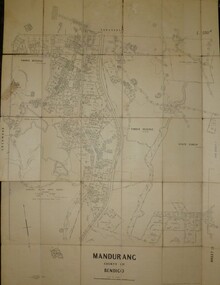
Map - JACK FLYNN COLLECTION: MANDURANG SHEET 2, March 1947
... Map: Parish of Mandurang, Sheet 2, County of Bendigo... and SurveyMelbourne, Victoria. March 1947. Map: Parish of Mandurang, Sheet 2 ...Map: Parish of Mandurang, Sheet 2, County of Bendigo. Parish plan.By Authority J.J.Gourley Government Printer Melbourne. Drawn and Produced at the Dept, of Lands and SurveyMelbourne, Victoria. March 1947.map, bendigo, parish plan, mandurang -
 Bendigo Historical Society Inc.
Map - JACK FLYNN COLLECTION: BET BET, 18/08/1931
... Map: Parish of Bet Bet, Counties of Gladstone and Talbot... at the Department of Lands and Survey, Melbourne. 18.8.31 Map: Parish of Bet ...Map: Parish of Bet Bet, Counties of Gladstone and Talbot . Parish plan.By Authority H.J. Green Govt, Printer. Photo Lithographed at the Department of Lands and Survey, Melbourne. 18.8.31map, gladstone, parish plan, bet bet, counties of gladstone and talbot. -
 Bendigo Historical Society Inc.
Map - SANDHURST (PART), Circa 1880's
... Map: Parish plan showing Charleston Rd. Lloyd St. area... Bendigo parish plan Sandhurst Charleston Road Lloyd street Map ...Map: Parish plan showing Charleston Rd. Lloyd St. areamap, bendigo, parish plan, sandhurst, charleston road, lloyd street -
 Bendigo Historical Society Inc.
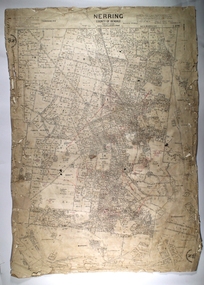
Map - NERRING, 25/08/1903 ?
... Map: Parish of Nerring, County of Bendigo. Parish plan...MAP Bendigo rural Nerring County of Bendigo Map: Parish ...Map: Parish of Nerring, County of Bendigo. Parish plan Canvas backedmap, bendigo, rural, nerring, county of bendigo -
 Bendigo Historical Society Inc.
Map - SANDHURST (PART), No date visible
... Map: Parish plan showing the Southwestern corner...MAP Bendigo parish plan Sandhurst Map: Parish plan showing ...Map: Parish plan showing the Southwestern corner of Sandhurst to the Municipal boundarymap, bendigo, parish plan, sandhurst -
 Bendigo Historical Society Inc.
Map - SANDHURST ? SHEET 5, 29/10/1879
... Map: Parish plan showing area Northwards from Kangaroo Flat...MAP Bendigo parish plan Parish of Sandhurst Kangaroo Flat ...Map: Parish plan showing area Northwards from Kangaroo Flatmap, bendigo, parish plan, parish of sandhurst, kangaroo flat -
 Bacchus Marsh & District Historical Society
Map, Village allotments, Parish of Myrniong, County of Bourke
... A single page paper map. A cadastral parish map of Myrniong... Parish Plan Myrniong Parish Maps Surveyed by John Hardy, Surveyor ...Myrniong is a village 9 kilometers west of Bacchus Marsh. Prior to 1863 the area was known as Blow's Flat. This map which was produced in 1903 and according to the catalogue record of this map held at the State Library of Victoria was based on an earlier map created in 1861. The early layout of streets for the village of Myrniong can be seen on this map. The streets shown are, Main Street, Hardy Street, Blow Street, Myrniong Street, Shuter Street, and Blackwood Street. An area marked as a reserve for a school can be seen between Hardy Street and Main Street.A single page paper map. A cadastral parish map of Myrniong in Victoria, showing numbered land allotments. Photo-lithographed at the Department of Lands & Survey, Melbourne, in 1903. Based on an original map created in 1861. The map is pasted into a bound volume containing 76 maps or plans in total. High resolution digital image stored on BMDHS computer network. Surveyed by John Hardy, Surveyor ; photo-lithographed at the Department of Lands & Survey, Melbourne by T.F. McGauran, 24.12.03myrniong parish plan, myrniong parish maps -
 Bendigo Historical Society Inc.
Map - JACK FLYNN COLLECTION: TARNAGULLA SHEET 4, 25/11/1926
... Map: Parish of Tarnagulla Sheet 4, Counties of Gladstone... Map: Parish of Tarnagulla Sheet 4, Counties of Gladstone ...Map: Parish of Tarnagulla Sheet 4, Counties of Gladstone and Bendigo. Parish plan.Photo-Lithographed at the Department of lands and Survey, Melbourne by W. J. Butson. 25.11.26map, gladstone, parish plan, tarnagulla sheet 4 -
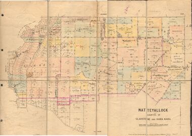 Bendigo Historical Society Inc.
Map - JACK FLYNN COLLECTION: NATTE YALLOCK, 22/06/1937
... Map: Parish of Natte Yallock, Counties of Gladstone...., of Lands and Survey, Melbourne, Victoria. Map: Parish of Natte ...Map: Parish of Natte Yallock, Counties of Gladstone and Kara Kara. Parish plan.By Authority H.J. Green Government Printer Melbourne. Drawn and Reproduced at the Depart., of Lands and Survey, Melbourne, Victoria.map, gladstone, parish plan, natte yallock -
 Bendigo Historical Society Inc.
Map - JACK FLYNN COLLECTION: LAANACOORIE, No date visible
... Map: Parish of Laanacoorie, County of Bendigo. Parish plan..., Printer. Map: Parish of Laanacoorie, County of Bendigo. Parish ...Map: Parish of Laanacoorie, County of Bendigo. Parish plan. Half of the sheet is missing.By Authority H.J. Green. Govt, Printer.map, bendigo, parish plan, laanacoorie -
 Bendigo Historical Society Inc.
Map - KANGAROO FLAT ?, Circa 1880
... Map: Parish plan showing area from Kangaroo Flat to Spring...MAP Bendigo parish plan Kangaroo Flat Spring Gully Map ...Map: Parish plan showing area from Kangaroo Flat to Spring Gullymap, bendigo, parish plan, kangaroo flat, spring gully -
Bendigo Historical Society Inc.
Map - HUNTLY, SHEET 4, 29/03/1876
... Map: Parish of Huntly, Sheet 4, County of Bendigo. Hand... Bendigo parish plan Huntly Map: Parish of Huntly, Sheet 4, County ...Map: Parish of Huntly, Sheet 4, County of Bendigo. Hand Draughted Parish plan. Originally in Map Cupboard. Relocated to Map Drawer 5 on 22.9.22. Too long for the map cupboard.map, bendigo, parish plan, huntly -
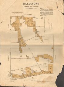 Bendigo Historical Society Inc.
Map - JACK FLYNN COLLECTION: WELLSFORD, 15/12/1941
... Map: Parish of Wellsford, County of Bendigo. Parish plan. 2... Bendigo parish plan Wellsford Map: Parish of Wellsford, County ...Map: Parish of Wellsford, County of Bendigo. Parish plan. 2 copies of the same plan.map, bendigo, parish plan, wellsford -
Bendigo Historical Society Inc.
Map - JANIEMBER WEST, 18/02/1913
... Map: Parish of Janiember West, County of Bendigo ( number... Bendigo rural Janiember West County of Bendigo Map: Parish ...Map: Parish of Janiember West, County of Bendigo ( number 140 in Map Cupboard 1)map, bendigo, rural, janiember west , county of bendigo -
 Bendigo Historical Society Inc.
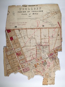
Map - TOOLLEEN ALLOTMENTS, circa 1870
... Map: Parish plan showing Village allotments at Toolleen...MAP Rodney Toolleen Parish of Toolleen county of Rodney Map ...Map: Parish plan showing Village allotments at Toolleen, Parish of Toolleen, County of Rodneymap, rodney, toolleen, parish of toolleen, county of rodney -
 Bendigo Historical Society Inc.
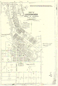
Map - LONG GULLY HISTORY GROUP COLLECTION: LOCKWOOD TOWNSHIP
... . Printed at the top of the map is: Parish map of Lockwood showing... is: Parish map of Lockwood showing location of Happy Jack's paddock ...Copy of a map of Township of Lockwood, County of Bendigo. Printed at the top of the map is: Parish map of Lockwood showing location of Happy Jack's paddock & hut and the sites of the Crown & Anchor Hotel and the original Happy Jack Hotel. Written on the map with arrows pointing to the site is: Happy Jack's Paddock, Site of the original Happy Jack Hotel and Happy Jack's Hut. An outline of Happy Jack's Paddock is drawn in.bendigo, history, long gully history group, the long gully history group - lockwood township, crown & anchor hotel, happy jack hotel, happy jack store, county of bendigo -
 Bendigo Historical Society Inc.
Map - JACK FLYNN COLLECTION: ARCHDALE, 15/01/1936
... Map: Parish of Archdale, County of Gladstone. Parish plan..., of Lands and Survey, Melbourne, Victoria. 15/01/36 Map: Parish ...Map: Parish of Archdale, County of Gladstone. Parish plan. The Allotments have been coloured in with pencil.By Authority H.J. Green, Government Printer Melbourne. Drawn and Reproduced at the Dept, of Lands and Survey, Melbourne, Victoria. 15/01/36map, gladstone, parish plan, archdale , gladstone -
Bendigo Historical Society Inc.
Map - PARISH OF LAANECOORIE, 13/10/1930
... Map: Parish of Laanecoorie, County of Bendigo. Parish plan... Bendigo parish plan Laanecoorie Map: Parish of Laanecoorie, County ...Map: Parish of Laanecoorie, County of Bendigo. Parish plan ( number 176 in Map Cupboard 1)map, bendigo, parish plan, laanecoorie -
Bendigo Historical Society Inc.
Map - PARISH OF DIGGORRA, 23/02/1911
... Map: Parish of Diggorra, County of Bendigo. Parish plan... Bendigo parish plan Diggorra Map: Parish of Diggorra, County ...Map: Parish of Diggorra, County of Bendigo. Parish plan ( number 247 in Map Cupboard 1)map, bendigo, parish plan, diggorra -
Bendigo Historical Society Inc.
Map - PARISH OF WHIRRAKEE, Surveyed 14/07/1904
... Map: Parish of Whirrakee. Hand Draughted Parish plan... Bendigo parish plan Whirrakee Map: Parish of Whirrakee. Hand ...Map: Parish of Whirrakee. Hand Draughted Parish plan (number 280 in map cupboard 1)map, bendigo, parish plan, whirrakee -
Bendigo Historical Society Inc.
Map - NOLAN, 11/04/1889
... Map: Parish of Nolan, County of Bendigo. Parish plan... Bendigo parish plan Nolan Map: Parish of Nolan, County of Bendigo ...Map: Parish of Nolan, County of Bendigo. Parish plan (number 346 in map cupboard 1)map, bendigo, parish plan, nolan -
Bendigo Historical Society Inc.
Map - GOORNONG, 21/08/1888
... Map: Parish of Goornong, County of Bendigo. Parish plan... Bendigo parish plan Goornong Map: Parish of Goornong, County ...Map: Parish of Goornong, County of Bendigo. Parish plan (number 345 in map cupboard 1)map, bendigo, parish plan, goornong -
Bendigo Historical Society Inc.
Map - ELMORE, 2/03/1880
... Map: Parish of Elmore, County of Bendigo. Parish plan... Bendigo parish plan Elmore Map: Parish of Elmore, County ...Map: Parish of Elmore, County of Bendigo. Parish plan. (number 344 in map cupboard 1)map, bendigo, parish plan, elmore -
Bendigo Historical Society Inc.
Map - EGERTON, 22/03/1892
... Map: Parish of Egerton, County of Bendigo. Parish plan... Bendigo parish plan Egerton Map: Parish of Egerton, County ...Map: Parish of Egerton, County of Bendigo. Parish plan (number 343 in map cupboard 1)map, bendigo, parish plan, egerton -
Bendigo Historical Society Inc.
Map - DIGGORA, 7/03/1892
... Map: Parish of Diggora, County of Bendigo. Parish plan... Bendigo parish plan Diggora Map: Parish of Diggora, County ...Map: Parish of Diggora, County of Bendigo. Parish plan (number 341 in map cupboard 1)map, bendigo, parish plan, diggora -
Bendigo Historical Society Inc.
Map - KIMBOLTON, 20/12/1907
... Map: Parish of Kimbolton, County of Bendigo. Parish plan... Bendigo parish plan Kimbolton Map: Parish of Kimbolton, County ...Map: Parish of Kimbolton, County of Bendigo. Parish plan. (number 339 in map cupboard 1)map, bendigo, parish plan, kimbolton