Showing 296 items matching "park west road"
-
 Kew Historical Society Inc
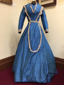
Clothing - Blue Silk Day Dress, 1860-1863
Joseph Butterworth COOMBS (1842-1901), was an accountant who founded a successful mercantile trading company. At the time of his marriage to Caroline Mary MICHEL in 1869, Coombs had already purchased ten acres of Studley Park. The acreage included land on the west of Fenwick Street that extended along lower Stawell Street to the corner of Yarra Street, all of it connected directly to the Yarra environs. A right of way to Studley Park Road was on the title, though Coombs went on to purchase more land, some of which faced Studley Park Road. In addition to owning the Studley Park acreage, Coombs later acquired 1,201 acres of land abutting the Acheron River. While retaining the Kew property he became a Taggerty Councillor and was Shire President for a time. J.B. Coombs died at Acheron Station in 1901 (aged 59 years). A few months after, tenders were called to repair the Kew dwelling, the Fenwick Street property now appearing in records with the name ‘Hope Mansell’. Caroline Coombs remained at Hope Mansell until she died in 1924, survived by three sons and five daughters. Not long after her death, advertisements appeared for the sale of the Studley Park land. The sale seems to have been a mechanism for distribution of the Estate, as the following year the original ten acre holding was transferred to members of the family. The eldest daughter Mabel married William Younger who, with his brother Alexander, developed Younger and Mackie Courts, both south of Studley Park Road. [Research: Kerry Fairbank]In 1961, the granddaughter of Joseph and Caroline Coombs, Mabel Isola (Younger) Grattan, donated ten 19th century dresses and parasols to the Kew Historical Society. The costumes, now known as the 'Coombs Collection', are the earliest recorded items of clothing to enter the Society's collection. Each of the items in the Coombs Collection, of which this item forms a part, is historically, aesthetically and socially significant. As a collection, the costumes includes outstanding examples of morning wear, day dresses, wedding dresses, and clothing accessories, providing evidence of outstanding dressmaker skills in Victoria during the mid to late Victorian period. One-piece, floor length blue silk day dress with a bell skirt that is slightly longer at the back. The dress is joined, centre-front with hooks and eyes. It is probable that the 19th century cream-coloured lace on the bodice and cuffs is a later addition. The lace extends in a long loop at the font of the skirt. The bodice has a high round neck, later modified to a V-shape. The dress must at one stage have been reconfigured or strengthened at the join of the bodice and skirt, as there is evidence of the use of new machine stitching. The dress is fully lined with a stiffened cotton lining fabric. Apart from minor staining, the dress is in excellent condition. The dress is the earliest complete costume in the collection. Measurements - 145.0 cm (centre back) 25.0 cm (waist, flat)Nilcoombs collection, fashion - 1860s, women's clothing, costumes, daywear -
 Kew Historical Society Inc
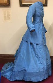
Clothing - Blue Silk Jacket & Skirt, 1868-1872
Joseph Butterworth COOMBS (1842-1901), was an accountant who founded a successful mercantile trading company. At the time of his marriage to Caroline Mary MICHEL in 1869, Coombs had already purchased ten acres of Studley Park. The acreage included land on the west of Fenwick Street that extended along lower Stawell Street to the corner of Yarra Street, all of it connected directly to the Yarra environs. A right of way to Studley Park Road was on the title, though Coombs went on to purchase more land, some of which faced Studley Park Road. In addition to owning the Studley Park acreage, Coombs later acquired 1,201 acres of land abutting the Acheron River. While retaining the Kew property he became a Taggerty Councillor and was Shire President for a time. J.B. Coombs died at Acheron Station in 1901 (aged 59 years). A few months after, tenders were called to repair the Kew dwelling, the Fenwick Street property now appearing in records with the name ‘Hope Mansell’. Caroline Coombs remained at Hope Mansell until she died in 1924, survived by three sons and five daughters. Not long after her death, advertisements appeared for the sale of the Studley Park land. The sale seems to have been a mechanism for distribution of the Estate, as the following year the original ten acre holding was transferred to members of the family. The eldest daughter Mabel married William Younger who, with his brother Alexander, developed Younger and Mackie Courts, both south of Studley Park Road. [Research: Kerry Fairbank]In 1961, the granddaughter of Joseph and Caroline Coombs, Mabel Isola (Younger) Grattan, donated ten 19th century dresses and parasols to the Kew Historical Society. The costumes, now known as the 'Coombs Collection', are the earliest recorded items of clothing to enter the Society's collection. Each of the items in the Coombs Collection, of which this item forms a part, is historically, aesthetically and socially significant. As a collection, the costumes includes outstanding examples of morning wear, day dresses, wedding dresses, and clothing accessories, providing evidence of outstanding dressmaker skills in Victoria during the mid to late Victorian period. Blue silk, floor length day dress comprised of a tightly fitted, long, waisted jacket joined by hooks and eyes at centre front. The bodice features large ornamental buttons from neck to waist, covered in a figured silk fabric of the same colour as the dress. The gown has extensive pin tucking on the sleeves, on the flounce of the skirt, and on the long train. The line of the outfit is emphasised by the flattened front, which is typical of the period. Its cut and lack of adornment emphasises the tailored effect.australian fashion, fashion & design, costumes, dresses, women's clothing, fashion - 1860s, fashion - 1870s -
 Kew Historical Society Inc
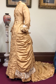
Clothing - Gold Silk Taffeta Wedding Dress with Silk Braid & Tassles, 1875-1880
Joseph Butterworth COOMBS (1842-1901), was an accountant who founded a successful mercantile trading company. At the time of his marriage to Caroline Mary MICHEL in 1869, Coombs had already purchased ten acres of Studley Park. The acreage included land on the west of Fenwick Street that extended along lower Stawell Street to the corner of Yarra Street, all of it connected directly to the Yarra environs. A right of way to Studley Park Road was on the title, though Coombs went on to purchase more land, some of which faced Studley Park Road. In addition to owning the Studley Park acreage, Coombs later acquired 1,201 acres of land abutting the Acheron River. While retaining the Kew property he became a Taggerty Councillor and was Shire President for a time. J.B. Coombs died at Acheron Station in 1901 (aged 59 years). A few months after, tenders were called to repair the Kew dwelling, the Fenwick Street property now appearing in records with the name ‘Hope Mansell’. Caroline Coombs remained at Hope Mansell until she died in 1924, survived by three sons and five daughters. Not long after her death, advertisements appeared for the sale of the Studley Park land. The sale seems to have been a mechanism for distribution of the Estate, as the following year the original ten acre holding was transferred to members of the family. The eldest daughter Mabel married William Younger who, with his brother Alexander, developed Younger and Mackie Courts, both south of Studley Park Road. [Research: Kerry Fairbank]In 1961, the granddaughter of Joseph and Caroline Coombs, Mabel Isola (Younger) Grattan, donated ten 19th century dresses and parasols to the Kew Historical Society. The costumes, now known as the 'Coombs Collection', are the earliest recorded items of clothing to enter the Society's collection. Each of the items in the Coombs Collection, of which this item forms a part, is historically, aesthetically and socially significant. As a collection, the costumes includes outstanding examples of morning wear, day dresses, wedding dresses, and clothing accessories, providing evidence of outstanding dressmaker skills in Victoria during the mid to late Victorian period. Single-piece, floor length, gold silk taffeta evening dress featuring the use of a very long fishtail train to which is attached a silk cord to allow the wearer to hold it above the floor. The dress includes a number of decorative features including the extensive use of box pleats on the sleeves and on the hem of the skirt; contrasting gold and cream braiding and tassles; and the extensive use of ruching on the bodice at the front. Due to the age and fine quality of the silk taffeta used, there is evidence of the degradation of the fabric on one shoulder and a tear in the rear of the skirt. Otherwise the dress is in excellent condition.fashion - 1870s, australian fashion, wedding dresses, costumes, women's clothing, coombs collection -
 Kew Historical Society Inc
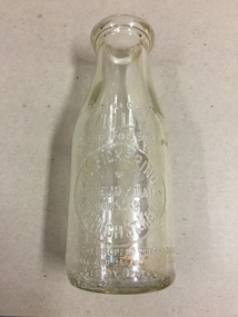
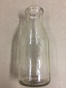
Container, FG Pickering, Milk Bottle, Twentieth Century
Pickering's Dairy was located on the south Side of High Street, Kew, between Charles Street and Highbury Grove. Kew was a major milk producing district in the Nineteenth and early Twentieth centuries, with three major dairy farms lining the Yarra between Studley Park in the west and Burke Road in the east. In addition to these dairy producers, there were also a number of accredited dairy retailers in the suburb. The largest and most enduring of these was the Model Dairy founded by the Kew pioneer James Venn Morgan. Milk bottles that include the name of the producer or retailer are historically significant as they represent a period in Kew's history before the mass production of milk in the second half of the Twentieth Century. A number of these named bottles have the additional attribute of rarity.Milk bottle - F.G. Pickering, Highbury Dairy, 344 High St., Kew. Pressed inscription: "This bottle contains MILK Bottled for Sale by F.G. Pickering, Highbury Dairy HAW5538, 344 High St., Kew. Bottle is the property of the above. It is loaned and cannot legally be used by others". Reverse: "One Imperial Pint". milk bottles, pickering's dairy (kew) -
 Kew Historical Society Inc
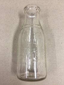
Container, White's Dairy, Milk Bottle, Twentieth Century
White's dairy was at 52 Willsmere Road, near the Peel Street Intersection. Descendant known locally as Miss White lived at 33 Willsmere Road. This is across the road from the dairy location. Kew was a major milk producing district in the Nineteenth and early Twentieth centuries, with three major dairy farms lining the Yarra between Studley Park in the west and Burke Road in the east. In addition to these dairy producers, there were also a number of accredited dairy retailers in the suburb. The largest and most enduring of these was the Model Dairy founded by the Kew pioneer James Venn Morgan. Milk bottles that include the name of the producer or retailer are historically significant as they represent a period in Kew's history before the mass production of milk in the second half of the Twentieth Century. A number of these named bottles have the additional attribute of rarity.Glass milk bottle from White's Dairy, North Kew. Pressed inscription: "This bottle contains milk bottled for sale by White's Dairy, North Kew, Phone HAW.2154. Bottle is the property of the above. It is loaned and cannot legally be used by others". Reverse: "One Imperial Pint". milk bottles, white's dairy (kew), north kew, willsmere road -
 Kew Historical Society Inc
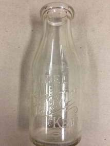
Container, Model Dairy, Milk Bottle, Twentieth Century
The Model Dairy was founded by the Kew pioneer, James Venn Morgan. The dairy had a number of different locations in Kew depending on the time period. Its final incarnation was on the north side of Cotham Road, between Ridgeway Avenue and Kent Street, Kew. The final factory was designed by the architects Bates, Smart and McCutcheon.Kew was a major milk producing district in the Nineteenth and early Twentieth centuries, with three major dairy farms lining the Yarra between Studley Park in the west and Burke Road in the east. In addition to these dairy producers, there were also a number of accredited dairy retailers in the suburb. The largest and most enduring of these was the Model Dairy founded by the Kew pioneer James Venn Morgan. Milk bottles that include the name of the producer or retailer are historically significant as they represent a period in Kew's history before the mass production of milk in the second half of the Twentieth Century. A number of these named bottles have the additional attribute of rarity.Milk bottle - Model Dairy Kew. Pressed inscription: "Model Dairy Ltd Kew." Reverse: " This bottle contains milk bottled for sale by Model Dairey Ltd and always remains their property. It is loaned & cannot legally be used by others. One Imperial Pint. This bottle differs from 1981.0010 in that it has two pressed rings on the neck of the bottle.milk bottles, model dairy (kew) -
 Kew Historical Society Inc
Container, Model Dairy, Milk Bottle, Twentieth Century
The Model Dairy was founded by the Kew pioneer, James Venn Morgan. The dairy had a number of different locations in Kew depending on the time period. Its final location was on the north side of Cotham Road, Kew between Ridgeway Avenue and Kent Street. Its final factory was designed by the architects Bates, Smart and McCutcheon.Kew was a major milk producing district in the Nineteenth and early Twentieth centuries, with three major dairy farms lining the Yarra between Studley Park in the west and Burke Road in the east. In addition to these dairy producers, there were also a number of accredited dairy retailers in the suburb. The largest and most enduring of these was the Model Dairy founded by the Kew pioneer James Venn Morgan. Milk bottles that include the name of the producer or retailer are historically significant as they represent a period in Kew's history before the mass production of milk in the second half of the Twentieth Century. A number of these named bottles have the additional attribute of rarity.Milk bottle - Model Dairy Kew. Pressed inscription: "Model Dairy Ltd Kew." Reverse: " This bottle contains milk bottled for sale by Model Dairey Ltd and always remains their property. It is loaned & cannot legally be used by others. One Imperial Pint. This bottle differs from 1981.0009 in that it does not have two pressed rings on the neck of the bottle.milk bottles, model dairy (kew) -
 Kew Historical Society Inc
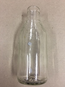
Container, Milk Bottles Recovery Ltd, Milk Bottle, 1930-1950
Milk Bottles Recovery Ltd began production in Melbourne in 1930. Its head office was located at 48 Market Street, Melbourne. It supplied milk bottles to dairies throughout metropolitan Melbourne, and possibly Victoria. It ended production in the 1950s. Smaller Kew dairies without their own named bottles, would have sourced bottles from a statewide provider such as Milk Bottles Recovery Ltd.Kew was a major milk producing district in the Nineteenth and early Twentieth centuries, with three major dairy farms lining the Yarra between Studley Park in the west and Burke Road in the east. In addition to these dairy producers, there were also a number of accredited dairy retailers in the suburb. The largest and most enduring of these was the Model Dairy founded by the Kew pioneer James Venn Morgan. Milk bottles that include the name of the producer or retailer are historically significant as they represent a period in Kew's history before the mass production of milk in the second half of the Twentieth Century. A number of these named bottles have the additional attribute of rarity.Milk bottle - Milk Bottles Recovery Ltd. Pressed inscription: "Milk. One Pint. This bottle belongs to Milk Bottles Recovery Ltd and cannot be used with out written permission. milk bottles, milk bottles recovery ltd -
 Kew Historical Society Inc
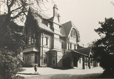
Photograph - 'Tara Hall', Studley Park Road, 1890-1900
During construction, commentators described the house as being in the ‘Elizabethan style’. The architectural style of the exterior, with its innovatory use of red brick and Italian tiles was more influenced by American models. Edward George Kilburn, of Ellerker & Kilburn, designed Byram for the industrialist George Ramsden in 1888.This is an original small photograph of this historic Kew mansion with provenance by descent from the first owners of the house.The main entrance to Tara Hall (previously named Byram, Goathland and Lowan). The entrance, through a porte-cochère, was located on the east side of the house. Inscription reverse: KH-323 Tara Hall once stood on Studley Pk Road on vast landscaped gardens. Donated by Mr Peter Ramsden, 49 Kamilaroy Road, West Pymble 2073 N.S.W. Dec.1979."byram, tara hall, lowan, goathland, edward g. kilburn (architect), george ramsden -
 Kew Historical Society Inc
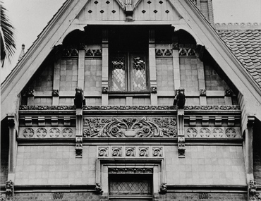
Photograph - Gable, 'Tara Hall', Studley Park Road, Marc Strizic, c.1960
'Lost Glories: a memorial to forgotten Australian buildings' was published by David Latta in 1986. It tells the story of a number of significant Australian buildings that had previously been demolished. A chapter in the book was devoted to Goathland, later known as Tara Hall. To supplement the text, he sourced photographs from a range of suppliers, chiefly the Royal Women's Hospital which had once owned Tara Hall, but had sold it in 1960. This is one of the photographs donated to KHS by the author.A detailed photograph of the main gable on the front of Tara Hall (previously named Byram, Goathland and Lowan). The façade included detailed terra cotta mouldings. The Kew Historical Society was gifted a remnant of this façade (ie. ‘East or West’) in 2013. The use of applied terra cotta decoration by the architect Edward George Kilburn, of Ellerker & Kilburn, is typical of his style of the period. Mark Strizic (1928-2012), photographer. byram, goathland, tara hall, lowan, studley park (kew), george ramsden, sir malcolm mceacharn, edward george kilburn (architect), studley park road (kew) -
 Kew Historical Society Inc
Map, MMBW, MMBW Plan No.40 Collingwood & Kew, 1900-1910
... of Kew, bordered on its north by Studley Park Road, in the west... Park Road, in the west by Walmer Street and the River Yarra ...The Melbourne and Metropolitan Board of Works (MMBW) was established by an act of the Victorian Parliament in 1890 to prepare for and to implement a sewerage and water reticulation system across what was then inner Melbourne, its surrounding and middle distance suburbs, including Kew. The MMBW was disbanded in 1991.The map collection of the Kew Historical Society has at its core the historic maps assembled and originally stored in the City Engineer's Department of the City of Kew. These include maps in a number of scales. The vast majority of maps were produced by the MMBW in the first two decades of the twentieth century, and are solid working maps, backed by linen for durability. These maps are historically significant to Kew, the City of Boroondara and to the history of the development of state utilities in Victoria. A number of the Kew maps have additional details added by former municipal officers, including the levels reached by various floods. As these were working documents, information was added to them long after the period of their initial production and distribution.Early map of part of the Borough of Kew, created in the first decade of the twentieth century, at a scale 160 ft to 1 inch. The map covers what was then the south western section of Kew, bordered on its north by Studley Park Road, in the west by Walmer Street and the River Yarra, by High Street South and Princess Street in the East and Barkers Road in the south. The map shows the extent of urban development by that time, prominent institutions and the outlines of built structures in the municipality. Contour lines and historic flood levels were added in ink to the map at a later stage.MELBOURNE AND METROPOLITAN BOARD OF WORKS / PLAN NO. 40 / COLLINGWOOD & KEWmelbourne & metropolitan board of works, mmbw maps, mmbw plans, borough of kew, cartography -
 Kew Historical Society Inc
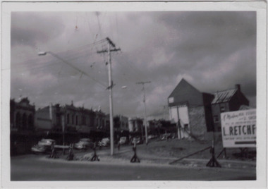
Photograph - Kew Junction during road widening, December 1958
Kew Junction is the intersection of five major roads - Denmark Street, High Street, High Street South, Studley Park Road and Princess Street. The original widening of High Street in the 1930s expanded that street by removing shops on the south side of the street from Cotham Road to Denmark Street. Further widening in 1958 removed shops at the west end of High Street to allow for increased traffic using Princes Street and Denmark Street.Original, black and white positive of Kew Junction, including the corner with Denmark Street during road widening in the 1958.Inscribed verso: "Kew Junction Dec 1958 / When the road was being widened by the removal of a number of shops / Notice saying Retchford's Estate agency's temporary office is at the top end of Denmark Street, Kew"kew junction, denmark street -- kew (vic.), major roadworks -- kew (vic.) -
 Brimbank City Council Art Collection
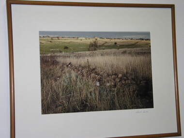
Photograph, Robert Pointon, River Rocks, 1988
Local Significance. Part of the 1989 Hunt Club Exhibition.West bank Kororoit Creek looking east. Looking directly across the creek. Foliage in the immediate foreground. Creek in the midground, Stone embankment across the river. - AR0038photograph, kororoit creek, robert, pointon -
 Brimbank City Council Art Collection
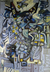
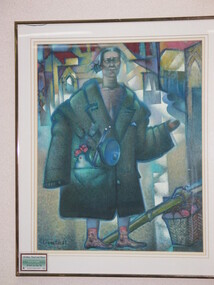
Painting, Dancing Unicorn, October 1984
Artwork based on a Vietnamese custom called "Dancing Unicorn Festival" Occuring at the "TET" during New Years and Autumn's full moon. Typical scene would include boys dancing with a "unicorn" and others dancing around. Sometimes this festival can be seen in Victoria. Artist associated with The Living Museum of the West.Le Van Tai. Dancing Unicorn. Gouache on paper, 76 x 52cm. Blue painting in a cubist / futurist style. -
 Brimbank City Council Art Collection
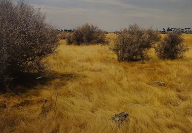
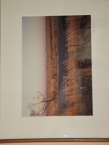
Photograph, Robert Pointon, West of Fairbairn Road, 1989
Local SceneWest of Fairbain Road facing east towards city with grasslands and box thorns. - AR0039 -
 Brimbank City Council Art Collection
Photograph, Kororoit Creek, Opposite Deer Park Hotel, 1994
Local LandscapeOpposite Deer Park Hotel, West Side Kororoit Creek looking East AR0108photograph, landscape -
 Brimbank City Council Art Collection
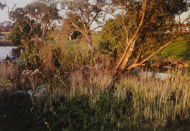
Photograph, Robert Pointon, From Essendon looking west over the Maribyrnong River towards Duke Street Quarries Essendon, early 1990s
Local SceneFrom Essendon looking west over the Maribyrnong River towards Duke Street Quarries Essendon - AR0017 -
 Brimbank City Council Art Collection
Photograph, Robert Pointon, John's Knife, 1988
Local SceneJohn's Knife - West bank of the Maribyrnong River facing south, colour photograph, -
 Brimbank City Council Art Collection
Photograph, Robert Pointon, West Bank of the Kororoit Creek looking north, 1988
Local SceneHuntsman Chemical works, West Bank of the Kororoit Creek looking north - AR0019 -
 Brimbank City Council Art Collection
Photograph, Robert Pointon, Looking west towards the Huntsman chemical complex & City West Sunshine, 1989
Local SceneDerrimut Grasslands - behind the Huntsman Chemical Complex - AR0015 and AR0035 -
 Brimbank City Council Art Collection
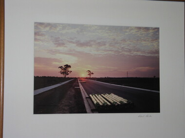
Photograph, Robert Pointon, Industrial Drive Facing West in South Sunshine, 1990
Local sceneLocal sceneColour Photograph - looking down a road at sunset - stacked pipes in foreground. Made as a series of three plates - AR0009 -
 Brimbank City Council Art Collection
Photograph, Robert Pointon, West Bank of Kororoit Creek, 1988
Local SceneWest Bank of Kororoit Creek - AR0033 -
 Brimbank City Council Art Collection
Photograph, Robert Pointon, West Bank of Maribyrnong River, North Sunshine, 1987
Local SceneWest Bank of Maribyrnong River, North Sunshine - AR0034 -
 Brimbank City Council Art Collection
Photograph, Robert Pointon, West of Fitzgerald Road, 1990
Local SceneRobert Pointon. West of Fitzgerald Road. Colour photograph, 34 x 49cm -
 Brimbank City Council Art Collection
Painting - Gouache on pape, Le Van Tai, Clothes, Food and Peace, March 1984
Artist associated with The Living Museum of the WestGouache on paper -
 Brimbank City Council Art Collection
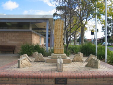
Sculpture - Public Art, Glengala Walk Monument, Unknown
Modern ArtUnknown. Glengala Walk. n.d, sandstone, Brimbank City Council, Brimbank.carved sandstone plinthsglengala walk, monument, glengala, sunshine west, sandstone -
 Surrey Hills Historical Society Collection
Book, Alan Judge Holt (deceased), Pre-Suburban Surrey Hills 1839-1883, 1989
Author: Alan Judge Holt amassed a significant collection of historical material related to the Surrey Hills area. Born in Moonee Ponds in 1912 to Edmund Holt and Ellen Ruby Sutton, he married Edna Jean Pallot in 1937. They lived at 62 Broughton Road, Surrey hills, had 3 sons and were strongly associated with the Surrey Hills Methodist Church. Alan was Secretary of the Victorian Lands Department and in his spare time recorded the occupancy of every property in Surrey Hills and Mont Albert at the beginning of each decade from 1890 to 1980. His collection of files and individual cards covers people, places, churches, clubs, businesses and other organisations in the area. Alan used this information to give talks and tours of the area and gifted his material to the local history collection through Jocelyn Hall.Unpublished manuscript / notes written by Alan Holt about settlers in and around Surrey Hills bound in-house. It is supported by maps showing landowners over various years from about 1840-1885(mr) henry jamieson, (mr) ken hall, (ms) edna holt, (mr) frank bamford, (mr) harrison buchanan, scouts, grange hill, wattle park, round hill, bona vista, mount albert, barton street, (mr) john raeburn, (mr) edmund holt, (mr) james dunn, butter merchant, mont albert road, elgar road, view hill, new street, surry mont, delany's hill, reservoir hill, riversdale road, middlesex road, surrey hills, (mr) aldo massora, aborigines, damper creek, back creek, west creek, kooyongkoot creek, (mr) john gardiner, (mr) chas mullins, (mr) henry elgar, (mr) robert campbell, (mr) alexander dyce, (mr) robert brooks, t budds payne, (mr) hugh glass, (mr) patrick trainer, w virtue, (mr) t fulton, (mr) john crimp, (mr) w dempsey, (mr) w e stanbridge, (mr) james atkinson, j porter, j collings, w edde, (mr) orlando fenwick, (dr)(mr) l l smith, (mr) j h knipe, (mr) george cockcroft, (sr) (mr) john martin kleinert, w morton, d delaney, a moeller, (mr) william smith, (mr) e.p.s.sturt, (mr) thomas blood, (mr) patrick mornane, (mr) henry de carle, w craig, j hill, w oliver, j keogh, a laing, vineyards, toll gates, (mr) david staig, (mr) phillip kleeper, (mr) goyder usher, (mr) james lawler, (mr) w.e. stanbridge, (mr) gideon rutherford, c a f mater, j gadsby, w h wrixon, e h lamont, i ainger, (mr) james henty, (mr) henry henty, w freemantle, w palmer, beckett park, maranoa gardens -
 Surrey Hills Historical Society Collection
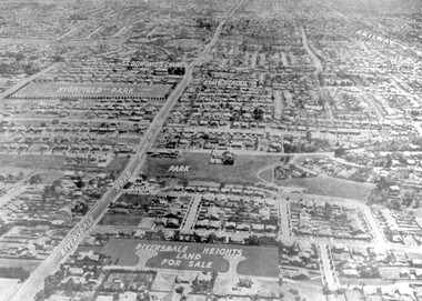
Photograph - Aerial view Riversdale Heights Estate area, c1923
This was probably part of a real estate promotion for the sale of the Riversdale Heights Estate. This was subdivided by Messrs. Duncan and Weller. Of the allotments offered, 30 were sold and realised £4600. Date of this sale was c December 1923. This suggests that the date This are was one of the last pieces of former rural land to be sub-divided for housing in Surrey Hills.The land between it and South Surrey Park was sub-divided post WW1, hence the naming of the streets after sites of WW1 battles.A black and white reproduction of an aerial photo of the area near the corner of Warragul and Riversdale Roads looking west towards the city. Some features have been identified by name including the Riversdale Heights Estate, which was being sub-divided. North and South Courts are shown. Other roads (unmarked) in the foreground are Graham Street, Allie Street, Thistle Street, Lille Street, Amiens Street, and Marne Street. Beyond these is the area marked 'PARK' (South Surrey Park), which is devoid of vegetation. Areas of Camberwell and Canterbury are also shown. The area covered extends to beyond St Dominic's Church. The original is mounted on a cream deckle-edged paper.Beneath the original on the mount: "SOUTH SURREY HILLS LOOKING WEST c. 1936" [The reference to the sale in the Box Hill Reporter of December 1923 found on Trove suggests that this date is not accurate.] Rear top LH corner of original in Jocelyn Hall's handwriting: "For Centre / from Mr James Long"riversdale heights estate, riversdale road, allie street, south surrey park, lille street, thistle street, amiens street, marne street, south court, north court, duncan and weller, real estate sales, graham street, st dominics church, highfield park, canterbury primary school, aerial photo -
 Wonga Park Community Cottage History Group
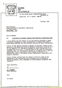
Work on paper (Item) - Letter, Wonga Park 1984 Letter from Shire of Lillydale to Wonga Park & District Residents' Association with four alternative intersection treatments
... on Jumping Creek Road Wonga Park east and west of the intersection... Old Yarra Road Wonga Park melbourne The Wonga Park ...The Wonga Park and District Residents' Association requested the Shire of Lillydale consider removing the crests on Jumping Creek Road Wonga Park east and west of the intersection with Yarra and Dudley Roads to improve visibility at the intersection. The Shire of Lillydale thought that this would simply increase the speed of traffic through the intersection and suggested a roundabout be built and came up with four alternative treatments. When they discovered that a roundabout would require water mains to be lowered and the M&MBW would not give a quote on the cost (which would be substantial) they opted for traffic islands instead. -
 Wonga Park Community Cottage History Group
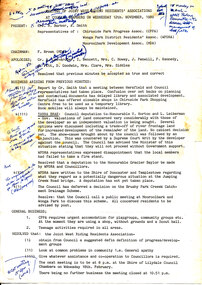
Document - Minutes, Wonga Park: 12 Nov 1980 Minutes of Joint West Riding Residents' Associations at Council Chambers