Showing 14427 items
matching property
-
 Melbourne Legacy
Letter - Document, letter, re Property 1267 Burke Road, East Kew, 1943
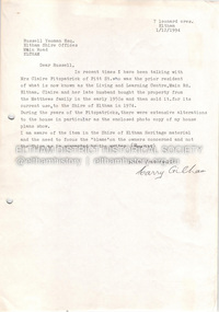
00331.1 A copy of the letter from the solicitor to the real estate agents that handled the transaction to claim for the return of items included in the purchase of the Holmbush property that were removed by the previous owner. 00331.2 A note to accompany the copy of the letter.Business practices in the 1940s around the purchase of the first property by Melbourne Legacy as a residence for children.00331.1 Quarto white copy paper, black type, two hole punched for filing. 00331.2 White note paper, black type, two hole punched for filing.holmbush initial negotiations, holmbush -
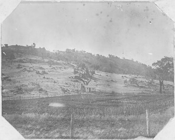 Stawell Historical Society Inc
Photograph, Man standing in paddock in front of Hut with hill behind believed to be the Sugarloaf -- Probably the McKay's property owned by McKay's
Man standing in paddock in front of Hut with hill behind believed to be the Sugarloaf. Probably the McKay's property owned by McKay's (2011). Originally part of Allanvale owned by the Bowtell Family. Located at the end of Graces Hill Road and continuation of Panrock Reservoir Road Extension. stawell -
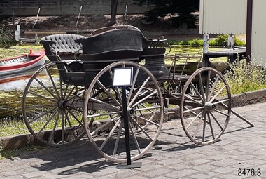 Flagstaff Hill Maritime Museum and Village
Vehicle - Murweh Carriage, c.1874
This private late-nineteenth-century four-wheeled carriage has been built to transport a family or group of passengers with a coachman in the front seat. It can be pulled by one horse, or by two horses if the T-pole is attached. The button fittings along each side of the carriage indicate that a folding roof or hood was once attached. The frame across the front of the carriagewas likely to have been a ‘dashboard’ with a leather or wood covering to prevent water, mud and other particles from splashing onto the passengers. The rear step between the two side-facing bench seats is adjustable to allow for ladies’ long skirts. These rear seats appear to be removable, in which case the carriage could be converted to a wagon to transport goods and equipment. The carriage could have been illuminated by oil or carbide lamps placed into the lamp holders on the sides. The carriage was kept under cover for many years in an open-front sandstone building that also included living quarters and an area that may have been stable. It was at ‘Murweh’ a Warrnambool property at 203 Liebig Street. The home is now Heritage and National Trust Listed and described as a ‘gentleman’s residence’. It was built by James Wotton Shevill in the 1860s. Shevill was a councillor from 1875 to 1878, serving in 1878 as Mayor of the Borough of Warrnambool. Jeremiah Wade lived at Murweh there from 1879-1880. By 1915 F.B. Whitehead and his family were living there, and by 1930 the address was used by Mr T.J. Rome and his family. Thomas James Rome was still using that address in September 1973 after his 100th birthday. It is believed that one of the property’s owners had been an Obstetrician in Warrnambool. The current owner re-told the story that children used to hide in the back section of the carriage and smoke, hidden from the sight of onlookers. He had heard the story from a previous owner.The well-appointed horse-drawn four-wheeled carriage is likely to have first belonged to a local councillor and past Mayor of the town of Warrnambool, J.W. Shervill, whose 1860s city property was the carriage location for many years. The carriage is a rare local example of a town-based lifestyle befitting a prosperous personality of the late 19th century. It adds to the story of Warrnambool's development as a town influenced by the port, wealth gained from shipping and the home place of prominent local people such as the Councillor and later Mayor. The side-facing rear seating is unusual for a passenger carriage. It has the feature of removable rear bench seats, allowing for the dual purpose of a carriage or wagon.Carriage; the Victorian-era horse-drawn four-wheeled open carriage has a coachman’s bench seat across the front and two side-facing bench seats in the rear. There are steps at the front on each side and a centre adjustable step and the back. It has a hinged shaft, two lamp holders and a separate T-pole. The bench seats have padded backrests upholstered in green leather and each has padded armrests at the ends. A rectangular metal frame, likely to have been a dashboard, is mounted across the front of the carriage. It has two inner vertical bars. The carriage's body is painted dark green with crimson highlights on some of the panelling. Decorative oval panels with hand-painted motifs are mounted along the sides. The side panels of the carriage have metal fastener buttons attached. The iron-rimmed wheels have sixteen wooden spokes and copper cuffs on the outside of the hubs, and the rear wheels are higher than the front wheels. Wooden brake blocks are mounted onto the back wheels and are active by a metal lever at the front right side of the carriage. The undercarriage is fitted with leaf springs on each side, mounted from front to back axles. Included are: (1) The separate T-pole that allows two horses to be harnessed to the carriage (2) Leather horse winkers with metal hardware and oval brass plate on the side of each winkerMotif painted on an oval panel [a musical lyre within a blue floral wreath flanked by scrolls] flagstaff hill maritime museum and village, warrnambool, great ocean road, shipwreck coast, murweh, buggy, cart, carriage, wagon, horse-drawn vehicle, victorian buggy, four-wheeled carriage, coachman’s seat, bench seat, side-facing benches, upholstered seats, victorian decals, heritage vehicle decoration, antique hand painting, hand painted decals, motifs, iron-rimmed wheels, wooden brake blocks, leaf springs, t-pole shaft, rear step, equine carriage, 19th century vehicle, victorian transport, transport, gentleman’s vehicle, james wotton shevill, councillor, mayor, jeremiah wade, f.b. whitehead, thomas james rome, warrnambool obstruction, warrnambool genealogy, warrnambool pioneers, victorian carriage, one horse carriage, two horse carriage, horse drawn carriage -
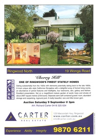 Ringwood and District Historical Society
Memorabilia - Booklet, Real Estate history of "Cherry Hill", 19 Wonga Road, Ringwood North, with property titles and subdivision plans of the 35 acres in the triangle bounded by Oban, Wonga and Warrandyte Roads
16 plastic pockets containing the history of "Cherry Hill". Titles and subdivision plans of the 35 acres in the triangle bounded by Oban, Wonga and Warranyte Roads, Ringwood North. Multi pocket burgundy coloured spiral binder containing 34 pages of the property history, subdivisions, land titles and photographs of the house, compiled by Richard Carter pre-auction 9 September 2006. Includes architectural descriptions of "Cherry Hill" from original allotment in 1872 to 2006. Also history of well known residents who lived in it. -
 Melbourne Tram Museum
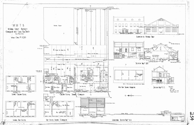
Drawing, Melbourne & Metropolitan Tramways Board (MMTB), "Howard Street Property - conversion into cable car depot", 1925
A4 sheet printed from a pdf file of the "Howard Street Property - conversion into cable car depot". Shows the changes to the buildings in order to provide a running depot for the cable cars that worked the Elizabeth St to Abbotsford line via North Melbourne. Depot required following the closure of the Flemington Road depot when it was converted to electric in July 1925. Drawing not dated. Two current photos of the buildings provided by Mal Rowe - Photos of the front of the buildings - 27/4/2013 and the rear 10/3/2013.trams, tramways, north melbourne, cable trams, conversion, howard st, depot -
 Glen Eira City Council History and Heritage Collection
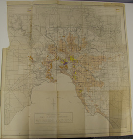
Map - Map, zoning, Metropolitan Town Planning Commission, "DISTRIBUTION AND USE OF EXISTING PROPERTY. MAP NO. 6.", 1929
The map titled: “Distribution and use of Existing property map No. 6” (Metropolitan Town Planning Commission Melbourne and Suburbs) is of historical significance. It is listed on page 168 of Chapter 4 the Zoning section of the "Plan of General Development Melbourne Report of the Metropolitan Town Planning Commission 1929" - Melbourne's first strategic plan. Map No. 6 is mentioned throughout Chapter 4 of the 1929 Report. It states on page 156 that this Map was created to graphically illustrate the data collected by the Planning Commission. The Map illustrates the general distribution of uses of existing property throughout the metropolitan area. The coloured sections show the areas which were developed or were in the process of development in 1929. The colours indicate the distribution of uses in the developed areas. The pink coloured areas, which include Caulfield, were almost completely residential.1929, metropolitan town planning commission, melbourne, suburbs -
 Eltham District Historical Society Inc
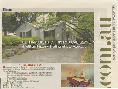
Document - Property Binder, 718 Main Road, Eltham
Newspaper advertisement: Diamond Valley Leader, 27 April 2005, property leased to State Member for Eltham.main road, eltham, property, state member for eltham -
 RMIT GSBL Justice Smith Collection
Book, Collins, C. M, The value of property compensation and land tax : being a treatise on the principles to be adopted in the valuation of all kinds of property, whether for compensation, rating, or any other purpose, and an exhaustive exposition of the law relating to Federal Land Tax, 1949
Third editioncompensation (law) -- australia, eminent domain -- australia, tax assessment -- australia, real property -- valuation -- australia, real property tax -- australia, land value taxation -- australia -
 Eltham District Historical Society Inc
Photograph, Peter Bassett-Smith, Jelbart property, Arthur Street, Eltham Mud Brick Heritage Excursion, 4 October 1998, 04/10/1998
[article in EDHS Newsletter No. 123, November 1998:] MUD BRICK HERITAGE EXCURSION AND THE FUTURE. A small group of members attended the excursion on 4th October. We visited a number of earth houses listed by the Eltham Heritage Study in a very pleasant day's outing. The first visit was to the home of Jenny and Brian Ellis in York Street, formerly the home of Jenny's father Professor William McMahon Ball. We were made very welcome with inspection of the inside and outside showing the various stages of construction. We then walked through the grounds of "Kinloch", the Jelbart property in Arthur Street where we saw their large mud brick house and barn. Lunch was at Marion and Russell Yeoman's house in Peter Street. This pise house was built by the Moore family in the early 1950's. In the afternoon we visited the home of artist Jenni Mitchell in Fordhams Road, one of the last examples of the work of Alistair Knox. Then we travelled to Laughing Waters Road where we saw two interesting houses owned and built by well known landscape gardener Gordon Ford. Along the way we stopped to view a number of other properties from the street.Colour photographactivities, eltham, heritage excursion, mud brick, arthur street, jelbart property -
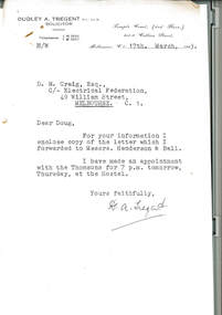
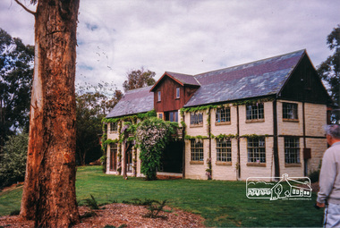
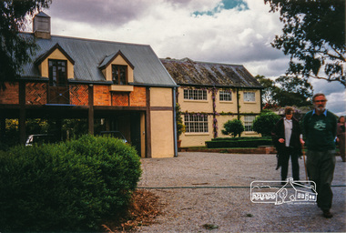
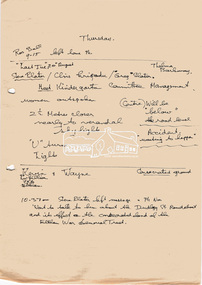
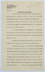 Melbourne Legacy
Letter, Re Balnarring Camp Property, c.1930
Referring to the legal history and transfer of land for the Junior Legacy Club Balnarring camp from Legatee Savige. Melbourne Legacy provided camps for junior legatees - the children of deceased servicemen. It started with outings to the property of Legacy founder, Legatee Stan Savige, who had a place in Balnarring. Permanent camp buildings were built in 1930. Lord Somers (Governor of Victoria) also ran a camp in the area and the area became known as Somers. These documents record the transfer of the land to Legacy. The camps gave the children an opportunity of a summer beach holiday with other Legacy children.An important record of the history of the land owned by Stan Savige that was used for Legacy Camp, it adds to the other material available about Legacy Camp at Somers.White foolscap paper with black typed x 5 pages. Single sided. Black type with red corrections and some grey lead remarks. Addressed to ‘The chairman,/ Junior Legacy Club,/ 55 Market Street,/ Melbourne. C.1. From ‘Yrs Faithfully/ sgd/ J.H. Armstrong and W. A. Tregent. See also collection item 00253. somers camp, properties, land transfer -
 Melton City Libraries
Photograph, Property of the Raleigh family, 1970
Raleighs Road - Property of the Raleigh family descendants of Reiersen family from Norway. Henry and wife Catherine had a small wooden house near Djerriwarrh Creek. Their daughters Catherine married Robinson, and Henrietta married Isaac Robinson of “Creighton” Toolern Vale Road. Henry’s Brother Oliver married Margaret McLean. Their children were, Elsie, Rupert, Lois, Annie, Albert and Olga. She died in September 1986. She was a long term organist at the Presbyterian Church. Lois and Annie were dressmakers ref 100 Years at Melton Isaac and Henrietta - Jeanette Robinson 1985Miss Raleigh's Shop, High Street Meltonpioneer families, local identies -
 Eltham District Historical Society Inc
Folder, Eltham War Memorial Garden and Property; Notes compiled by Harry Gilham, 1996-1997, 1996-1997
Contents: 1. Notes concerning impact upon Eltham War Memorial Garden of a proposed roundabout at Dudley Street, Eltham, September 1996 - In 1996 Nillumbik Shire Council proposed the provision of traffic lights or a roundabout to alleviate traffic concerns at the intersection of Main Road with Dudley street and Panther Place. The Society had no real concerns with Panther Place as it had no perceived impact upon Shillinglaw Cottage however survey pegs for a new road alignment to provide for a roundabout at Dudley Street were placed within the Eltham War Memorial Gardens which was significant concern. Harry Gilham, then President of the Society was on the working group with Council and the RSL to discuss this proposal. Ultimately it did not proceed and traffic lights were installed. No action occurred at Panther Place. 2. Notes pertaining to Eltham Town Focus Group and the Eltham War Memorial Trust property, c.January 1997 - These notes from Harry Gilham relate to a draft report "A Community Vision for 'The Eltham War Memorial Trust' Property Main Road, Eltham" being prepared at the request of Chief Commissioner Don Cordell, Nillumbik Shire Council, 31st January 1997. Harry handed over these notes to Jim Connor on 14 March 2010. Jim had replaced Harry as President of the Eltham District Historical Society in 2009. They also reference Stanley S. Addison's Outline History of the Eltham War Memorial Trust30 pages of various types, mainly A4, printed and with notes by hand or handwritten notes (drafts)chief commissioner don cordell, dudley street, eltham rsl sub-branch, eltham town focus group, eltham war memorial garden, eltham war memorial trust, main road, panther place, returned services league, roundabouts, shire of nillumbik, stanley s addison -
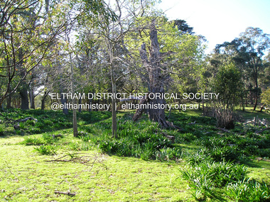
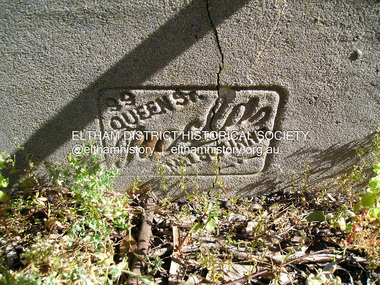
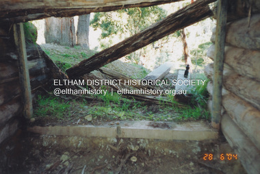 Eltham District Historical Society Inc
Photograph, Fay Bridge, Former Morrison property, Killeavey, Laughing Waters Road, Eltham, 28 June 2004
Beatrice Wanliss Irvine was the daughter of former Victorian Premier Sir William Irvine. From age 13 she lived at “Killeavey” off Laughing Waters Road (later accessed from Reynolds Road). In 1923 she married James Morrison and the couple received Killeavey as a wedding gift. The property supported fruit and vegetable growing as well as an impressive botanical garden. But James died in 1936 after a period of ill health, leaving Beatrice to support their six children. The Killeavey house was built atop a cliff, 40 metres above the Yarra River. The garden was designed in 1910 by William Guilfoyle who was the second director of the Royal Botanical Gardens. The house was totally destroyed in the Black Friday bushfires in 1939, but was rebuilt. Beatrice continued to live at Killeavey and became well regarded as a botanist and naturalist. She died in 1989 and is buried in Eltham Cemetery with her husband and one of their sons. The (rebuilt) house was demolished by Parks Victoria. It contains significant garden remnants. The surrounding bushland is valued for its significant plant communities.fay bridge collection, 2004-06-28, beatrice wanliss morrison (nee irvine), eltham, james morrison, killeavey, laughing waters road, william irvine -
 Eltham District Historical Society Inc
Photograph, Fay Bridge, Former Morrison property, Killeavey, Laughing Waters Road, Eltham, 30 August 2019
Beatrice Wanliss Irvine was the daughter of former Victorian Premier Sir William Irvine. From age 13 she lived at “Killeavey” off Laughing Waters Road (later accessed from Reynolds Road). In 1923 she married James Morrison and the couple received Killeavey as a wedding gift. The property supported fruit and vegetable growing as well as an impressive botanical garden. But James died in 1936 after a period of ill health, leaving Beatrice to support their six children. The Killeavey house was built atop a cliff, 40 metres above the Yarra River. The garden was designed in 1910 by William Guilfoyle who was the second director of the Royal Botanical Gardens. The house was totally destroyed in the Black Friday bushfires in 1939, but was rebuilt. Beatrice continued to live at Killeavey and became well regarded as a botanist and naturalist. She died in 1989 and is buried in Eltham Cemetery with her husband and one of their sons. The (rebuilt) house was demolished by Parks Victoria. It contains significant garden remnants. The surrounding bushland is valued for its significant plant communities.fay bridge collection, beatrice wanliss morrison (nee irvine), eltham, james morrison, killeavey, laughing waters road, william irvine, 2019-08-30 -
 Eltham District Historical Society Inc
Photograph, Fay Bridge, Former Morrison property, Killeavey, Laughing Waters Road, Eltham, 27 October 2019
Beatrice Wanliss Irvine was the daughter of former Victorian Premier Sir William Irvine. From age 13 she lived at “Killeavey” off Laughing Waters Road (later accessed from Reynolds Road). In 1923 she married James Morrison and the couple received Killeavey as a wedding gift. The property supported fruit and vegetable growing as well as an impressive botanical garden. But James died in 1936 after a period of ill health, leaving Beatrice to support their six children. The Killeavey house was built atop a cliff, 40 metres above the Yarra River. The garden was designed in 1910 by William Guilfoyle who was the second director of the Royal Botanical Gardens. The house was totally destroyed in the Black Friday bushfires in 1939, but was rebuilt. Beatrice continued to live at Killeavey and became well regarded as a botanist and naturalist. She died in 1989 and is buried in Eltham Cemetery with her husband and one of their sons. The (rebuilt) house was demolished by Parks Victoria. It contains significant garden remnants. The surrounding bushland is valued for its significant plant communities.fay bridge collection, beatrice wanliss morrison (nee irvine), eltham, james morrison, killeavey, laughing waters road, william irvine, 2019-10-27 -
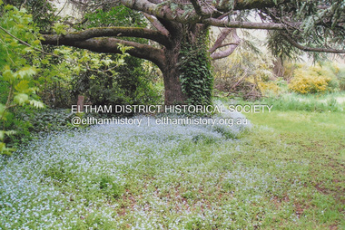 Eltham District Historical Society Inc
Photograph, Fay Bridge, New Zealand Oak at former Morrison property, Killeavey, Laughing Waters Road, Eltham, n.d
Beatrice Wanliss Irvine was the daughter of former Victorian Premier Sir William Irvine. From age 13 she lived at “Killeavey” off Laughing Waters Road (later accessed from Reynolds Road). In 1923 she married James Morrison and the couple received Killeavey as a wedding gift. The property supported fruit and vegetable growing as well as an impressive botanical garden. But James died in 1936 after a period of ill health, leaving Beatrice to support their six children. The Killeavey house was built atop a cliff, 40 metres above the Yarra River. The garden was designed in 1910 by William Guilfoyle who was the second director of the Royal Botanical Gardens. The house was totally destroyed in the Black Friday bushfires in 1939, but was rebuilt. Beatrice continued to live at Killeavey and became well regarded as a botanist and naturalist. She died in 1989 and is buried in Eltham Cemetery with her husband and one of their sons. The (rebuilt) house was demolished by Parks Victoria. It contains significant garden remnants. The surrounding bushland is valued for its significant plant communities.fay bridge collection, beatrice wanliss morrison (nee irvine), eltham, james morrison, killeavey, laughing waters road, william irvine, new zealand oak -
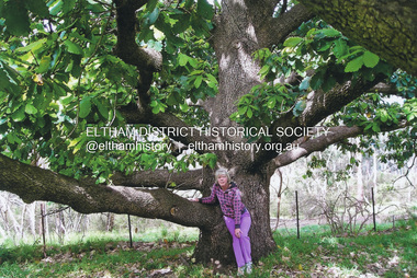 Eltham District Historical Society Inc
Photograph, Fay Bridge, Fay Bridge with New Zealand Oak at former Morrison property, Killeavey, Laughing Waters Road, Eltham, n.d
Beatrice Wanliss Irvine was the daughter of former Victorian Premier Sir William Irvine. From age 13 she lived at “Killeavey” off Laughing Waters Road (later accessed from Reynolds Road). In 1923 she married James Morrison and the couple received Killeavey as a wedding gift. The property supported fruit and vegetable growing as well as an impressive botanical garden. But James died in 1936 after a period of ill health, leaving Beatrice to support their six children. The Killeavey house was built atop a cliff, 40 metres above the Yarra River. The garden was designed in 1910 by William Guilfoyle who was the second director of the Royal Botanical Gardens. The house was totally destroyed in the Black Friday bushfires in 1939, but was rebuilt. Beatrice continued to live at Killeavey and became well regarded as a botanist and naturalist. She died in 1989 and is buried in Eltham Cemetery with her husband and one of their sons. The (rebuilt) house was demolished by Parks Victoria. It contains significant garden remnants. The surrounding bushland is valued for its significant plant communities.fay bridge collection, beatrice wanliss morrison (nee irvine), eltham, james morrison, killeavey, laughing waters road, william irvine, new zealand oak, fay bridge -
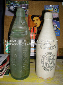 Eltham District Historical Society Inc
Photograph, Fay Bridge, Old bottles found at former Morrison property, Killeavey, Laughing Waters Road, Eltham, 2019
Lemonade, Non-alcoholic Hop Beer and milk bottlkes recovered from Killeavey give an insight into the types of drinks consumed by the Morrison family. Beatrice Wanliss Irvine was the daughter of former Victorian Premier Sir William Irvine. From age 13 she lived at “Killeavey” off Laughing Waters Road (later accessed from Reynolds Road). In 1923 she married James Morrison and the couple received Killeavey as a wedding gift. The property supported fruit and vegetable growing as well as an impressive botanical garden. But James died in 1936 after a period of ill health, leaving Beatrice to support their six children. The Killeavey house was built atop a cliff, 40 metres above the Yarra River. The garden was designed in 1910 by William Guilfoyle who was the second director of the Royal Botanical Gardens. The house was totally destroyed in the Black Friday bushfires in 1939, but was rebuilt. Beatrice continued to live at Killeavey and became well regarded as a botanist and naturalist. She died in 1989 and is buried in Eltham Cemetery with her husband and one of their sons. The (rebuilt) house was demolished by Parks Victoria. It contains significant garden remnants. The surrounding bushland is valued for its significant plant communities.fay bridge collection, beatrice wanliss morrison (nee irvine), eltham, james morrison, killeavey, laughing waters road, william irvine, bennett lemonade, bottles, milk bottle, o'neill bros north fitzroy, r. harrison, r. harrisons hop beer -
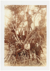 Chelsea & District Historical Society Inc
Photograph - Mr Alfred Morton with his brothers and friends, Bike picnic at Morton's property, c 1890
Alfred Louis Morton (known as Louis) was born in Geelong in 1866, the fifth of eleven children of Mark Morton and Eliza nee Heard (married 1898). Alfred began work for the Post Office at South Yarra in the 1890s. In the late 1800s it was common for people from Melbourne and north of the city to travel to Chelsea area beaches for their holidays and many liked the area so much that, like the Mortons, they moved here permanently. In the 1890s Alfred’s sister, Mrs William Ashmore, built a weekend house at the foot of what is now Foy Avenue in Chelsea. The Morton family, including Alfred, visited the area often, camping on the foreshore during the 1890s. In 1911 Alfred moved his family permanently to a house on the corner of Morton Grove and Main Road Chelsea (now known as the Nepean Highway) on property that extended from the main road to the beach. This house was destroyed in the fire of 22 December 1913 which raged amongst the ti-tree on the foreshore between Aspendale and Chelsea. Many buildings were destroyed in this fire. The Argus newspaper reported on Wednesday 24 December that 94 houses were burnt with glowing embers blown a mile and half inland. According to the Argus but for the wide break provided by the Point Nepean Road (now the Nepean Highway) and the railway line, the scrub on the other side might have caught. The Morton children, Elsa and Ivan, attended Chelsea State School (now Chelsea Primary School) and Mrs Morton was active in the establishment of St Chad’s Church of England in Chelsea. At the age of 80 in 1945 Mr Morton was concerned about reports that English children had lost their toys due to the war and so he made (as part of a wider effort in Australia) 100 toy engines that were sent to England. He died in 1946 in Chelsea. Sepia photograph of Mr Alfred Morton with his brothers in law and friend at Carrum in the 1890's, some perched in a tree others grouped at the base of the tree, bikes in the foreground.bike riding, picnic, morton, morton grove, chelsea, carrum -
 Eltham District Historical Society Inc
Document - Property Binder, 739 Main Road, Eltham
Letter 1 December 1994 from Harry Gilham to Russell Yeoman Eltham Shire Offices, re history of property: sold by Matthews family to Claire Fitzpatrick and husband, then sold to Shire of Eltham for Living and Learning Centre, 9 November 1994 sketch plan.main road, eltham, property, houses, shops, businesses, claire fitzpatrick, eltham living and learning centre -
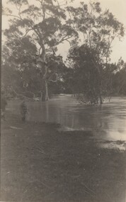 Stawell Historical Society Inc
Photograph, Whitehall Property Greens Creek
Hutchings family 1. Wimmera River in flood below Whitehall running a banker c. 1920. Ted & Col Hutchings in foreground. 2. Wimmera River in flood looking downstream. No date but possibly same time as no. 1. from same place. 3. Looking over the Wimmera River to Island paddock towards Greens Creek 4. Wimmera River half a banker at Whitehall 5. Wimmera River in flood upstream from carpenter's shop looking towards engine house at Whitehall 5a. Wimmera River in flood. Left to right - blacksmith shop and carpenters' shop. 5b. Taken from the same spot with Emily & Ada Hole, E G (Ted) & Col Hutchings. Blacksmith shop & carpenters' shop, Whitehall. 5c. Wimmera River upstream from the carpenters' shop. Foreground is possibly Belladonna lilies which were all over the river bank in 1992. Whitehall. 5d. Looking downstream towards the loose boxes, Whitehall. 5e. Blacksmiths' shop and carpenters' shop from the pumping station. Wimmera River, Whitehall. 6. Wimmera River in flood at Whitehall. 7. Wimmera River half a banker in front of old hut at Whitehall. 8. Wimmera River Emily Hayes, Edward G (Ted) Hutchings & Colin J Hutchings. 9. Morrl-Morrl - Greens Creek Road opposite back paddock. Whitehall. Black Ford in distance. c. 1919 10. Whitehall woolshed north east aspect, Drive to the right of photo 11. Whitehall woolshed - north east aspect showing the drive to the right 11a. Whitehall woolshed - north aspect 11b. Same tree near woolshed 11c. Same tree again in centre, other trees came up after the 23 flood. Woolshed to the right out of photo. 12. Whitehall woolshed - south aspect, sheep entrance end 13. Whitehall. left to right, Stackyard, stables in the centre and the Wimmera River behind following the trees. 14. Whitehall horse paddock c. 1920. left to right, Machinery shed, stable in the centre. Homestead to the right in distance. There is no windmill. 15. Load of wool from Whitehall woolshed to right. 16. Whitehall c. 1920 before the windmill. left to right, garage and mens' hut. Wimmera river runs along the tree line. 16a. Stables, garage and mens' hut after the construction of the windmill. River behind. 17. Whitehall c. 1922. Note windmill addition. Garage to left, Mens' Hut to right. Jack Donnelly & Edward G (Ted) Hutchings with pet lambs. River behind trees. 18. Whitehall gardens. Summer house to the right, pine tree lined drive in the centre background. Ted & Col Hutchings on the lawn. C. 1920 19. Edward G. (Ted) & Colin J. Hutchings in Whitehall garden. Wimmera River in the background. The building behind the fence is the carpenters' shop which the family lived in while house was rebuilt after fire 15 Jan 1877 20. Whitehall c. 1920. left to right, cattle yard, killing house, Wimmera river behind the fence, and the loose box on the right. Black Orpington chooks in foreground. 21. Bay window (original blinds) in the master bedroom. Whitehall 20 Sep 1992 22. Master bedroom (original wallpaper) Joyce & Col Hutchings, Moyu, Ben & Rebecca Roe 20 Sep 1992 23. Col & Ted's bedroom (original) Marble mantlepiece had been removed. Whitehall. 20 Sep 1992 24. Whitehall kitchen. Large yellow meat oven to left of stove, bread oven far left, extreme right is oven where milk heated to skim cream. Chimney was a central one shared with meat oven. Bread oven chimney separate. 20 Sep 1992 25. Whitehall dairy, made of natural stone with dried brick corners. Entrance behind creeper which is over trellis. 20 Sep 1992. This building still remains in 1 Jun 2023 26. Inside charcoal lined meat cellar. Bottom right is concrete vat for pickling meat in brine. Top of brickwork slightly above ground level. Whitehall 20 Sep 1992 27. Fire foreground was stable flooring which was to left of photo. Machinery shed (thatch roof). 4 posts far left remains of cowshed. Large post in centre foreground is the gate post of corral. River to right. 20 Sep 1992 28. Whitehall machinery shed. Posts on far right are cow shed. Over the river is the island paddock. Wimmera river runs behind machinery shed. 20 Sep 1992 29. Posts of 10 sided corral. Killing house by side of gum tree in centre of photo on far side of corral. To left is one of the bales of the cowshed. Whitehall. 20 Sep 1992 29a. Similar photo in the 1920's. To the right is horsebreaking corral, then cow shed, loose box, haystacks and stable on left. Whitehall. 30. Dining room fire place put in the open fire of the mens' hut, only the chimney remains. To the left is the drive & river. Rebecca Roe, Col Hutchings granddaughter. 20 Sep 1992 30a. Looking down the Whitehall Drive. Mens' Hut (Jack Donnelly in doorway) and garage far left. 1920's 30b. The Drive, Whitehall taken from in front of the mens' hut. Wimmera River on the left. Gum tree on left still there 20 Sep 1992. 30c. Reverse from 30a. Whitehall drive from the front gate looking towards the mens' hut and garage. c. 1926 30d. Curly Donohue leaving for Warracknabeal. Ex mail contractor Omeo to Bright Victoria. C. 1926 30e. Looking down the drive towards front gate. Mens' hut on the right, river on the left. 31. Whitehall from the side. Building in centre behind David is separater room. 2 roomed hut to left of separater room and remains of mens' hut chimney. Photo 16 taken from similar spot. 20 Sep 1992 32. Benjamin Roe (Col Hutchings grandson) in the Carpenters' shop. The family lived in this building after the fire in the 1870's. Whitehall 20 Sep 1992 33. Ford across the Wimmera River at Whitehall (River abt. 5 feet higher than normal) 20 Sep 1992 33a. Wimmera River, Whitehall 34. Site of old bridge before Col Hutchings time. Tree in foreground to right still has bolt from bridge work protuding. A large post was in the centre of photo to make equal distance. 20 Sep 1992 35. Entrance to the old ford. Colin J Hutchings & his daughter, Moyu Roe. Wimmera River, Whitehall 20 Sep 1992 36. Summer house at Whitehall 20 Sep 1992 looking down to the orchard, dark green trees in distance old fruit trees. 36a. Edward & Colin Hutchings in front of the Summer house, Whitehall c. 1921 36b. Summer house looking towards front gate. Whitehall. 36c. Grey thrush in nest box which can be seen in previous photo with summer house in the background. Whitehall. 36d. Summer house from the orchard side. Whitehall. 37a. South side of Whitehall. First window Edith Sutherland's room, 2nd window, Ted & Col's room, bay window master bedroom 38. Taken in middle of front path looking towards front gate. Edith Sutherland in garden. Date palm in centre, cotton palm to left. Whitehall c. 1920's 38a. Garden at Whitehall taken from near the cotton palm. 39. Whitehall 20 Sep 1992 Bay window-master bed, small window to r. of bay-Colin Hutchings born in, front door, window to right-dining room, round the corner- drawing room, window on right, spare bed, verandah on left is spare bed. 39a. Whitehall c. 1920's Date palm on the right. 39b. Win, Colin T & Colin J Hutchings. Date palm in background. Whitehall 1943 39c. Edward George, Colin Thomas, Elizabeth Ambler & Colin James Hutchings wearing RAAF uniform. Date Palm in background. Whitehall c. 1943 39c. Front garden of Whitehall looking from the front right side of the house towards the drive & Wimmera River. Date palm on right, cotton palm on left 20 Sep 1992 40. Taken from bottom left corner of front garden looking towards the summer house. Cotton palm on right. River to the left. 41. Elizabeth A Hutchings beside master bedroom window. Whitehall c. 1920 42. Whitehall (photo of a painting by Wallace) owned by Colin T Hutchings 1982. 42a. Whitehall painting by Wallace after restoration now owned by Nick Hutchings 2021 42b. Whitehall c. 1923 42c. Taken from the side garden looking towards the right side of house. Front door is to the left out of photo. The cotton palm is to the left. c. 1923 43. Signpost showing Whitehall 20 Sep 1992, All ground up to the tree line behind the signpost was Whitehall property. 44. Colin T. Hutchings age 9 mths. Mar 1943 Whitehall 45. Colin James, Elizabeth Ambler & Edward George Hutchings. Front garden by the date palm, Whitehall c. 1939-40 45a. Colin James, Edward George, Edward Thomas Hutchings & E. Winifred May & Barney (dog) Whitehall. c. 1939-40. 45b. Colin James & Colin Thomas Hutchings during drought & World War ll c. 1944-45 in front of cotton palm, date palm to right. 46. Garden at Whitehall. Jack Donnelly on the hand mower. Cotton palm on left, date palm behind Jack and roof of carpenters shop to right. 47. Colin J Hutchings on tractor, E. Tom Hutchings behind. Whitehall, c. 1933 48. Jack Donnelly (Tad) & Colin J. Hutchings. Cotton palm to right. Whitehall c. 1917-18 49. Edward G (Ted) & Colin J Hutchings with cockatoo outside the dairy in rear garden. Whitehall c. 1923 50. Taken from the windmill looking across the roof of the mens' hut to the garden, orchard and drive in Winter time. House is behind the trees to right, Wimmera River to the left out of picture. Whitehall. 50a. Not labelled by Col Hutchings. It is an aerial shot looking towards the house in the trees & seems to be taken from the top of a tree...on the river side. 51. E. Tom Hutchings & George Chambers dam sinking. Whitehall. 51a. Tom Hutchings & George Chambers dam sinking. Whitehall. 51b. E. Tom Hutchings dam sinking. 52. Emily Hayes & Ada Hole (sisters) with Tom, Col & Ted Hutchings at the woolshed. 53. E T (Tom) Hutchings on reaper & binder. Whitehall. 54. Orchard looking towards the house. Carpenters' shop and river on the right. Whitehall. 54a. Orchard looking from the house, dark trees in background form part of the drive. 55. Grasshopper plague, Christmas Day 1933. Whitehall 56. Frost on the front lawn, Whitehall. 57. Little red hen & chicks with the river in the background 58. Edward (Ted) G. Hutchings muscovy ducks, hay shed and trees along the river in the background. 58a. Edward (Ted) G Hutchings muscovy ducks. 59. Swimming in the Wimmera River, either Ted or Col Hutchings in the foreground. 60. Looking towards the fowl house and pigsty, Whitehall. 61. Snake on the path, Whitehall. c. 1923 61a. E. Tom Hutchings killing a snake, Whitehall. c. 1923 61b. E. Tom Hutchings killing a snake, Whitehall. c. 1923 62. Notice of clearing sale, Stawell News & Pleasant Creek Chronicle on 5 Apr 1916 where the stock & whole of the household furniture was to be sold by James Hutchings widow. 63. Back to Greens Creek 7 Jun 1987 Colin J Hutchings left and Belle Kindred centre looking at photo 64. Back to Greens Creek 7 Jun 1987 Colin J Hutchings centre, Graham Stewart holding photograph on the right. 65. Colin J Hutchings & Bill Walker. Back to Greens Creek 7 Jun 1987 66. Colin J Hutchings delivering a speech before the plaque unveiling. Back to Greens Creek 7 Jun 1987 67. Graeme Williamson & Colin J Hutchings (2 'old boys') Greens Creek School Site 7 Jun 1987 68. Graeme Williamson talking to Moyu Roe (Hutchings) in background is May Williamson. Back to Greens Creek 7 Jun 1987 69. Greens Creek SS, Edward (Ted) & Colin J Hutchings attended. 70. Original students of first Greens Creek School 7 Jun 1987 Back row left 1. Kindred 3. Colin J Hutchings 4,5,6 not known 7. Graeme Williamson Sitting left 1. Not an original 2,3,4, not known 5. Belle Kindred 71. Terrier at Greens Creek State School 72. The new school students Back to Greens Creek 7 Jun 1987. Perry twins standing in centre and the teacher kneeling front left. 73. Will Rees water colour 1925 signature 74. Will Rees water colour 1925 75. Shearing at Kirkellar. Allen Simpson's 76. Back to Greens Creek 7 Jun 1987 Colin J Hutchings left and Belle Kindred centre looking at photo 77. Back to Greens Creek 7 Jun 1987 Colin J Hutchings centre, Graham Stewart holding photograph on the right. 78. Colin J Hutchings & Bill Walker. Back to Greens Creek 7 Jun 1987 79. Colin J Hutchings delivering a speech before the plaque unveiling. Back to Greens Creek 7 Jun 1987 80. Graeme Williamson & Colin J Hutchings (2 'old boys') Greens Creek School Site 7 Jun 1987 81. Graeme Williamson talking to Moyu Roe (Hutchings) in background is May Williamson. Back to Greens Creek 7 Jun 1987 82. Greens Creek SS, Edward (Ted) & Colin J Hutchings attended. 83. Original students of first Greens Creek School 7 Jun 1987 Back row left 1. Kindred 3. Colin J Hutchings 4,5,6 not known 7. Graeme Williamson Sitting left 1. Not an original 2,3,4, not known 5. Belle Kindred 84. Shearing at Kirkellar. Allen Simpson's 85. Terrier at Greens Creek State School 86. The new school students Back to Greens Creek 7 Jun 1987. Perry twins standing in centre and the teacher kneeling front left. Digital Copy of Parish Maps Kara Karahomestead -
 Ringwood and District Historical Society
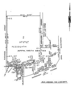
Document - Folder, Commercial and Retail Property Sales Information, Civic Place and Melbourne Street, Ringwood - 1998
45 photocopied pages including - Plan of Subdivision No.LP80718, Parish of Ringwood, Victoria, Crown Portion 12(Part) and part of a former government road Ref Vol 8668 Fol 745. - Vendors Statement, Planning Certificate and Heritage Council (Victoria) Certificate issued for 20 Melbourne Street, Ringwood. - Maroondah City Council Land Information Certificate for 149 149A and 149B Maroondah Highway; number 8 Civic Mall; and numbers 16, 20, 22 & 24 Melbourne Street Mall. - Yarra Valley Water statements relating to encumbrances for Shop 11, 149 Maroondah Highway; Shop 10, 149A Maroondah Highway; Shop 9, 149B Maroondah Highway; numer 8 Civic Place; Unit 3, 20 Melbourne Street; Office 4, 20 Melbourne Street; Shop 7, 22 Melbourne Street; and Shop 8, 24 Melbourne Street. - Land Tax Certificate pertaining to Commonwealth Bank, Civic Place, Ringwood. - Certificate of Title Vol 8892 Fol 906, Lot One on Plan of Subdivision No. 80718, Parish of Ringwood - Hanover Developments P/L - 29th June, 1971. -
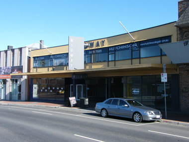 Ringwood and District Historical Society
Photograph - Multiple, Midway Arcade at 145-147 Maroondah Highway, Ringwood in 2008. Was one of Ringwood's premier retail locations. Arcade was auctioned on 10 December 1997 and sold to Eastland Property Holding Ltd, 2008
Before Stage 5 of the expansion of Eastland and REALM.Digital photographs only -
 Ringwood and District Historical Society
Photograph, Mullum Mullum Creek, fenced garden of a Munro St property that has encroached into the creek boundary 29th October 1989, 1989
Digital photograph -
 Bendigo Military Museum
Administrative record - Army Survey Regiment Sergeants Mess Property for Tender 1996, Army Survey Regiment, Bendigo, 1996
The Royal Australian Survey Corps and the Army Survey Regiment was disbanded in 1996 and the Sergeants Mess was closed. This is a list of Sergeants Mess propert that was being disposed of by tender.Two paper pages of typed lists of items for sale by tenderroyal australian survey corps, rasvy, fortuna, army survey regiment, army svy regt, asr -
 Eltham District Historical Society Inc
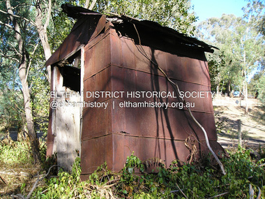
Photograph, Fay Bridge, Old outhouse constructed from recycled materials on a private property on way to St Andrews, 17 April 2019
Vacuum Oil Company https://en.wikipedia.org/wiki/Vacuum_Oil_Company Henry Bamford and Sons Uttoxeter, England https://henrybamfordandsonsuttoxeterengland.co.uk/1931-1945/fay bridge collection, 2019-04-17, bamford stationary engine, england, pump, st andrews, the bamford diesel, uttoxeter, vacuum oil company pty ltd -
 Eltham District Historical Society Inc
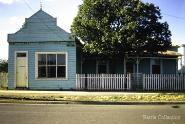
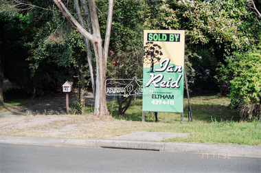
Negative - Photograph, Unidentified property: Real Estate Sign; Sold by Ian Reid Real Estate P/L, 126 Bolton Street, Eltham, 17 Nov 1992
Street with rollover kerbingRoll of 35mm colour negative film, 4 strips Fuji 1001992, houses, ian reid real estate, real estate agent -
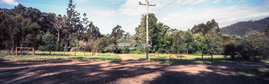 Eltham District Historical Society Inc
Negative - Photograph, Unidentified rural property, Eltham district, c.1985
Roll of 35mm colour negative film, 1 strip, 3 framesKodak CL200 5093driveway, infrastructure, residential, rural property, unsealed road