Showing 247 items
matching public garden reserve
-
 Ballarat Tramway Museum
Literary work - Manuscript, "Conductor 23"
"Conductor 23" by H.P.James (1899 - 1949) as given to Ballarat Historical Society, 13/11/1945. This typewritten copy of 9 pages is virtually similar to earlier copies of "Conductor 23"as per Trolley Wire No.268 February 1997, pp3 -11, with additional material relating to tram travelling public of Ballarat & Mrs. Grubb's prayer meetings with "Trammies". - Stapled along top edge. (Photocopy as well). pdf image added 11-12-2016. Photo copy labelled 530Atrams, tramways, ballarat, horse trams, esco, conductors -
 Ballarat Tramway Museum
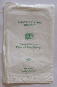
Functional Object - Printed Paper Bag, Milldean Press, Ballarat Vintage Tramway, c1985
White paper bag printed both sides with green ink, "Ballarat Vintage Tramway, BTPS old logo tram (31), Operates weekends, Public & school holidays" & postal address. Bag has serrated top and bottom (folded), & glued join. Hole in one corner at top for string connection. Second copy added 6/8/2002. Image from another bag added 3/8/2010trams, tramways, commerce, sales, btm, btps -
 Ballarat Tramway Museum
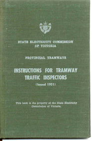
Document - Instruction Book, State Electricity Commission of Victoria (SECV), "Instructions for Tramway Traffic Inspectors", 1951
Demonstrates aspects of the SEC governance system in issuing By-laws for the travelling public, as part of their Act. Yields information about fares charged for tram services in Ballarat, Bendigo and Geelong. Issued to crews.Small book with 32 pages, 27 printed on, with green cloth hard covers, sewn into cover. On front cover, printed in white ink is SECV name, logo, words, "Provincial Tramways", "Instructions for Tramway Traffic Inspectors", "Issued 1951", and a note that the book remains the property of the SEC. Inside cover as above with location for name and date to whom book was issued to. Indexed. Contents gives rules for behaviour, ticket checking procedures, reports, traffic supervision, safety and accidents. Copies 2 and 3 on display in cabinet in 39 since 1992 until 10/04. Copies 4, 5 and 6 - each have BTPS Catalogue Number written in on title page. (revised 12/8/05) Copy 7 - added 17/1/2007 - issued to Dave Kellett. Copy 9 - added 6/12/15 - issued to Tramway Superintendent - Les Denmead - 25/7/1952. Full pdf scan added 28/5/2019. See Reg Item 7887 for a typed sheet that formed part of the book.Copies 4, 5 and 6, on title page, each have "Ballarat Tramway Preservation Society Catalogue No. 304" written in black ink on the top of the page. Copy 7 has "D.C. Kellett, 11-7-66" in ink on the first page.trams, tramways, rules, instructions, tramways, operations, management -
 Ballarat Tramway Museum
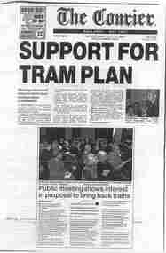
Document - Photocopy, The Courier Ballarat, "Support for Tram Plan", Aug. 2002
Photocopy of parts of pages 1 and 2 of the Courier, Ballarat, 31/7/2002, titled "Support for Tram Plan" written by Catherine Best. The item reports on the meeting held the previous day at the Town Hall to explain the details of the $20m proposal to return trams to the streets of Ballarat. Notes the Couriers web poll. Has photos of Ballarat Tourism Board chair Judy Verlin and of part of the crowd at the meeting. Full Image and 2nd copy of sheets added 14-1-2016 from donation of Kathy Stanley. Second copy - Has date and page number written in under headline in ink.trams, tramways, ballarat city tramway, public meeting, ballarat revival -
 Ballarat Tramway Museum
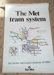
Poster, Metropolitan Transit Authority (MTA), "The Met / tram system", c1988
Diagrammatic poster or map of "The Met / tram system" showing a plan with route numbers, zones and peak system route numbers with an enlarged central Melbourne area. Date of map 1988c, shows the St. Kilda and Port Melbourne light rail, Bundoora and the "The Met" logo. Printed on art paper. Has a telephone number for further information. Stored rolled. St. Kilda and Port Melbourne light rail opened late 1987. The Met replaced by the Public Transport Corporation 1/7/1989 - See reference. Two copies held. See Time-line history of Melbourne's Government Cable and Electric Trams and Buses.trams, tramways, melbourne, map, the met, tram routes -
 Ballarat Tramway Museum
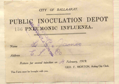
Certificate, City of Ballaarat, "Public Inoculation Depot / Pneumonic Influenza", 1919
Certificate contained within Reg. Item 2526, page 8 titled "Public Inoculation Depot / Pneumonic Influenza". Printed form on paper with perforated left hand edge, to record the H.P. James of ESCo had received the two injections for the Spanish Influenza outbreak of 1919. Formed signed by Geo. F. Morton as Acting Town Clerk. Has been stamped that the second injection had been received. The required date for the 2nd injection was 4/2/1919. H.P. James refers to the outbreak in the item on the retirement of Bob Haines (Reg. Item 2529), and notes he was the "Dispenser-Inspector" of two quinine powders to each man and that they had to wear gauze masks. S Note Item Not formally Numbered. A photocopy of the manuscript is held with the work sheet.Has stamped number '136' on form.tramways, trams, esco, tram crews, personnel, influenza -
 Ballarat Tramway Museum
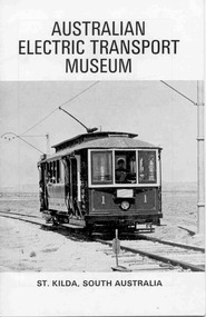
Book, Australian Electric Transport Museum (SA) Inc, "Australian Electric Transport Museum / St Kilda, South Australia", 1974
Thirty two page book, centre stapled, art paper, titled "Australian Electric Transport Museum / St Kilda, South Australia", guide book for the Museum, printed 1974. Gives information on AETM's exhibits, including ex Ballarat trams 21 and 34. Has maps of the AETM, Adelaide, Trolley buses system and brief history of Adelaide public street transport.trams, tramways, adelaide, trolley buses -
 Ballarat Tramway Museum
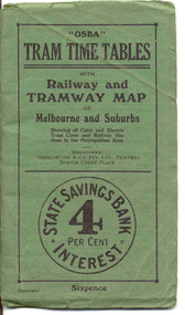
Ephemera - Timetable/s, Osboldstone & Co Pty Ltd and Printers and Publishers Melbourne, "OSBA Tram Time Tables with Railway and Tramway Map, of Melbourne and Suburbs", 1920's
Yields information about the tram timetables applicable to Melbourne's trams, including cable and electric and demonstrates the spread of Melbourne's public transport system in the early 1920's.Forty Eight page printed book contained with oversize green heavy paper covers centre stapled with a coloured map glued into the rear cover of the book titled "OSBA Tram Time Tables with Railway and Tramway Map, of Melbourne and Suburbs". Published c1920 - shows Footscray system, Victoria St Flemington link, does not show Puckle St. Timetables details Fares, first and last cars for cable and electric lines, sections and other details of the various lines. Note page 44 and 45 cannot be accessed, paper not cut correctly during the printing process - leave as is. Map prepared by Gawler and Drummond Architects, shows in colour the cable routes, electric tramways, authorised tramways and railway lines. Municipalities shown in different colours. Map folded into 12 sections. Published by Osboldstone & Co Pty Ltd, Printers and Publishers, Temple Court Place, Melbourne. Price 6d. Full scan of document added as a pdf file 5/6/2019. map, timetables, melbourne, cable trams -
 Ballarat Tramway Museum
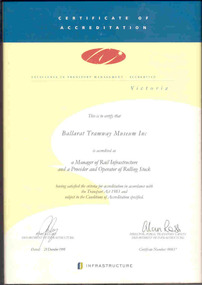
Certificate - Framed Certificate, Department of Infrastructure, BTM Rail Safety Accreditation 1998, 21/12/1998 12:00:00 AM
Framed certificate for the Accreditation of the Ballarat Tramway Museum as a Manager of Rail Infrastructure and Provider and Operator of Rolling Stock. The certificate signed by the Acting Secretary Department of Infrastructure and Alan Ross, Director of Public Transport Safety. Framed with a wooden glazed frame, with a sheet of heavy cardboard and taped in. Certificate printed on preprinted paper - Certificate No. 37. Has a hook on the top.trams, tramways, rail safety accreditation, museum, btm -
 Ballarat Tramway Museum
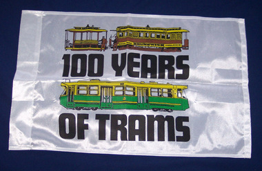
Flag, MTA 1985 Centenary, 1985
A flag or banner made for the centenary of Melbourne trams in 1985 by the Metropolitan Transit Authority to be used on the route number boxes on Melbourne W class trams. Made from a synthetic fabric, sewn on all four edges, with left hand edge made with a slot to fit a wooden pole. Features a cable tram - with a bogie cable trailer and Melbourne Z class tram, with the words "100 years of Trams" Two copies held.trams, tramways, melbourne, centenaries, flags, public transport -
 Ballarat Tramway Museum
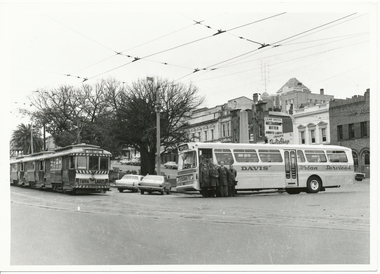
Photograph - Black & White Photograph/s, The Courier Ballarat, 17/08/1971 12:00:00 AM
Demonstrates the evolution of public transport in Ballarat, from tram to bus with the first of the replacement buses adjacent to a tram about to be phased out.Black and White copy photograph of a newspaper photograph taken by The Courier - photo taken 17/8/1971 and published in the Courier Supplement of 20/9/1971, showing first tramway replacement bus near Grenville St loop, August 1971 (another pic of the bus was published on 18/8/1971). Shows a Davis Bus with four drivers standing along side with three single truck trams in the loop - No. 13 at the rear. Has the Camp Hotel and the Ballarat Courier Offices in the background. See Reg Item 3720 also for another use of this photograph. Collected by Alan Bradley from the Ballarat Courier early 1980's. See Excel file "Record of Ballarat Courier Photos SEC era" (Archive Documents) for source of details.On rear stamped "Copyright, The Ballarat Courier Proprietary Limited." with "88%" in blue ink.tramways, trams, closure, buses, davis bus lines, sturt st, tram 13 -
 Ballarat Tramway Museum
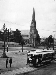
Photograph - Black & White Photograph/s, 1905
Yields information about the opening configuration of the trams and the street scene at the corner of Sturt and Lyons Streets. Also shows two well dressed men standing alongside the tram.Black and White copy photograph of a Public Records Office, Ballarat Office photograph at the time of the opening of the tramway. Photo taken in 1905 at the corner of Lyons and Sturt St with St Andrews Kirk church in the background. Shows the lighting at the intersection, passengers on the ESCo tram and two well dressed men alongside the tram track. Tram has the destination of Gardens. Collected by Alan Bradley from the Public Records Office Ballarat early 1980's. Used in The Golden City and its Tramways - page 54tramways, trams, sturt st, electrification, lyons st, st andrews kirk, opening, esco -
 Ballarat Tramway Museum
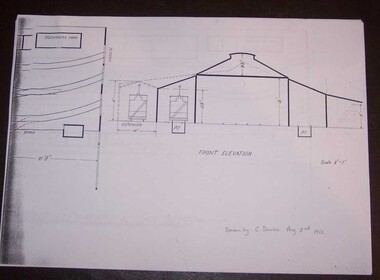
Document - Photocopy, Alan Bradley, "Plan and Front Elevation of Car Depot", 2000
Set of three A3 size photocopies of a drawing held by the Public Records Office Victoria of the Ballarat ESCo Tramway Depot, dated 2/8/1912. Drawn at a scale of 1/16" = 1', shows building layout, track layout, overall dimensions, a proposed extension to hold eleven trailers, a front elevation showing pits, extension (drawn at 1/8" = 1'). On the current tracks, shows the individual track capacities - 26 trams. Drawings copied by Alan Bradley for archives and research.trams, tramways, ballarat, esco, depot, drawings -
 Ballarat Tramway Museum
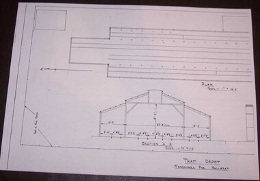
Document - Photocopy, Alan Bradley, "Tram Depot / Wendouree Pde. Ballarat", 2000
Set of four A3 size photocopies of a drawing BA-T11-8574 held by the Public Records Office Victoria of the Ballarat SEC Tramway Depot, dated c1936. Drawn at a scale of 1" = 16', shows building layout, track layout, overall dimensions, fence types and gates. A front elevation showing the new facade and an internal elevation (drawn at 1/8" = 1'). Drawings copied by Alan Bradley for archives and research.trams, tramways, ballarat, sec, depot, drawings -
 Ballarat Tramway Museum
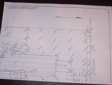
Document - Photocopy, Alan Bradley, "Car Depot / Wendouree Pde.", 2000
Set of four A3 size photocopies of a drawing VB4/8709c held by the Public Records Office Victoria of the Ballarat SEC Tramway Depot, dated 5/11/1971, Revision C 22/11/1971. Drawn at a scale of 1" = 20', shows building layout, track layout, overall dimensions, tree locations, pit details, rooms, paint shop, reduced levels, streets, toilets, steps to pits, tennis court and datum point. Drawn after the closure of the tramways, possibly to enable planning for the redevelopment and sale of the property. Drawings copied by Alan Bradley for archives and research.trams, tramways, ballarat, sec, depot, drawings -
 Ballarat Tramway Museum
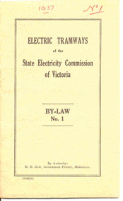
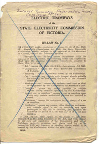
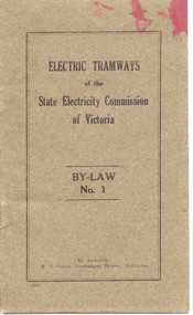
Book, State Electricity Commission of Victoria (SECV), "Electric Tramways of the State Electricity Commission of Victoria By-Law No. 1", 1943
Demonstrates aspects of the SEC governance system in issuing By-laws for the travelling public, as part of their Act. Yields information about fares charged for tram services in Ballarat, Bendigo and Geelong. Issued to crews.Twenty Four page booklet, plus medium weight card brown colour covers centre stapled. Book cover has title "Electric Tramways of the State Electricity Commission of Victoria By-Law No. 1". Pages are numbered pages 1 to 24, revoking By Laws dated 5/9/1932 (See Reg. Item 3109). Dated 9/3/1937. Gives definitions, fares and charges, regulations re passengers, behaviour, smoking, dangerous goods, luggage and behaviour of crews. Gives schedule of fares and charges for Ballarat, Bendigo and Geelong. Fares applied from 1937 to 1949 - see Reference. Details names of SEC Commissioners, Minister in Charge of Electrical Undertakings. Four copies held. Copy 1 - as printed. Copy 2 - has numerous changes marked in red ink internally and pasted in changes to the text. The schedules have been crossed out. Copy 3 - has changes marked in black ink, including fare and charges changes that were made in 1949. No pasted in sections. Copy 4 - missing back cover. Copy 5 - missing front and back pages. Has Government Printer, H. E. Daw, number 11928/43. Given the printing number on Reg. Item 3110 is a lower number and that the H. Green was the Government Printer in 1936 (See Reg. Item 3068), "43" indicates a reprinting date. See Fares in Ballarat – from Alan Bradley 11/4/2005 – appendix for Book Copy 1 - has "1937" and "No. 1" written in red ink on top of cover. Copy 2 - has "No. 2" written in red ink in top right hand corner of cover and "Ballarat Tramway Preservation Society No. 202" written in black ink on top of cover and numerous changes marked in red ink internally and pasted in changes to the text. The schedules have been crossed out in red ink. Copy 3 - has "Ballarat Tramway Preservation Society No. 202" written in black ink on top of cover and numerous changes marked in black ink including changes to fares and schedules.trams, tramways, secv rules, by laws, tickets, fares, ballarat, bendigo, geelong -
 Ballarat Tramway Museum
Book, State Electricity Commission of Victoria (SECV), "Electric Tramways of the State Electricity Commission of Victoria By-Law No. 1", 1932
Demonstrates aspects of the SEC governance system in issuing By-laws for the travelling public, as part of their Act. Yields information about fares charged for tram services in Geelong when the SEC took over from MESCo.Eight page booklet, centre stapled. Booklet has title "Electric Tramways of the State Electricity Commission of Victoria By-Law No. 1". Pages are numbered pages 1 to 7 Gives definitions, by-laws, fares and charges, special cars, workmen cars, regulations re passengers, behaviour, nuisances, smoking, dangerous goods, luggage and behaviour of crews. Gives schedule of sections for Geelong only. Details names of SEC Commissioners. Three copies held, all with some marked changes - see inscriptions. Copy 2 - stamped as received "11/3/1936". Has Government Printer number 12195. Basis was probably used in Ballarat and Geelong when the SEC took over until the 1937 edition issued though with fare schedules gazetted. See Fares in Ballarat – from Alan Bradley 11/4/2005 – appendix for Book Copy 1 - has "Ballarat Tramway Preservation Society No. 201" written in black ink on top of cover, a large blue cross on the front cover, on change noted on page 2, with authorisation details, pencil name on front cover that has been rubbed out, and pencil drawings on back cover and dirt marks. Has been folded vertically. Copy 2 - has "Ballarat Tramway Preservation Society No. 201" written in black ink on top of cover, has been folded vertically. Copy 3 - has "Ballarat Tramway Preservation Society No. 201" written in black ink on top of cover, numerous changes in black ink throughout the booklet, in particular the word "car" substituted by "tram", renumbering of clauses and deletion of the Geelong schedule.trams, tramways, secv rules, by laws, tickets, fares, geelong -
 Ballarat Tramway Museum
Book, State Electricity Commission of Victoria (SECV), "Electric Tramways of the State Electricity Commission of Victoria By-Law No. 1", 1937
Demonstrates aspects of the SEC governance system in issuing By-laws for the travelling public, as part of their Act. Yields information about fares charged for tram services in Ballarat, Bendigo and Geelong. Issued to crews.Twenty Four page booklet, plus medium weight card dark brown colour covers centre stapled. Book cover has title "Electric Tramways of the State Electricity Commission of Victoria By-Law No. 1". Pages are numbered pages 1 to 23, revoking By Laws dated 5/9/1932 (See Reg. Item 3109). Dated 9/3/1937. Gives definitions, fares and charges, regulations re passengers, behaviour, smoking, dangerous goods, luggage and behaviour of crews. Gives schedule of fares and charges for Ballarat, Bendigo and Geelong. Fares applied from 1937 to 1949 - see Reference. Details names of SEC Commissioners, Minister in Charge of Electrical Undertakings. Copy has numerous changes marked in red ink internally and pasted in changes to the text. Has Government Printer number 6967. Given the printing number on Reg. Item 3108 is a higher number and that H. Green was the Government Printer for this book and in 1936 (See Reg. Item 3068), indicates a copy printed in 1937. A piece of paper has been pinned to the copy on page 23, giving details of where to relieve on the Sebastopol route. Written in red ink. See Fares in Ballarat – from Alan Bradley 11/4/2005 – appendix for Book Copy - has numerous changes marked in red ink mainly, some pencil, internally and pasted in changes to the text.trams, tramways, secv rules, by laws, tickets, fares, ballarat, bendigo, geelong -
 Ballarat Tramway Museum
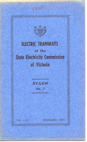
Book, State Electricity Commission of Victoria (SECV), "Electric Tramways of the State Electricity Commission of Victoria By-Law No. 1", 1955
Demonstrates aspects of the SEC governance system in issuing By-laws for the travelling public, as part of their Act. Yields information about fares charged for tram services in Ballarat, Bendigo and Geelong. Issued to crews.Twenty page booklet, plus medium weight card blue colour covers centre stapled. Book cover has title "Electric Tramways of the State Electricity Commission of Victoria By-Law No. 1". Along the bottom edge is the printing number "TYE 1-27" and date, "November 1955" Pages are numbered pages 1 to 20, amending By Laws dated 9/3/1937 (See Reg. Item 3108) and with a list of subsequent dates in the first paragraph. Dated by the SEC 20/10/1955. Gives definitions, fares and charges, regulations re passengers, behaviour, smoking, dangerous goods, luggage and behaviour of crews. Gives schedule of fares and charges for Ballarat, Bendigo and Geelong. Fares applied from 1949 to 1951 - see Reference. Details names of SEC Commissioners, Minister in Charge of Electrical Undertakings on rear page. Five copies held. See also Reg Item 3508 for other copies. No printer details. Full pdf copy added 28/5/2019 - scanned from a spare copy. See Fares in Ballarat – from Alan Bradley 11/4/2005 – appendix for BookCopy 1 & 2 - has "1955" in black ink on top of front cover. Copy 2 - has "Ballarat Tramway Preservation Society No. 204" written in black ink on top of cover. Copy 3 & 4 - has "Ballarat Tramway Preservation Society No. 204" written in black ink on top of cover . Copy 4 - has marks and an "X" alongside rule 34(ii), page 11. Copy 5 - has "Carter. R" in blue ink along top edge of covertrams, tramways, secv rules, by laws, tickets, fares, ballarat, bendigo, geelong -
 Ballarat Tramway Museum
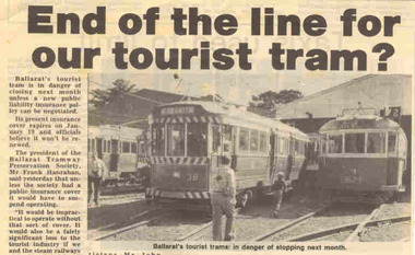
Newspaper, The Courier Ballarat, "End of the line for our tourist tram", 28/12/1985 12:00:00 AM
Small item about the BTPS tram operations facing the mini 1985 public liability crisis, compared to the early 2000's crisis. Notes other railway that had closed. Problem was resolved by the State Govt and the State Insurance office.Newspaper clipping, from The Courier, 28-12-1985, titled "End of the line for our tourist tram", about the problems the railways (Bellarine Peninsula Railway had closed) getting public liability insurance. Quotes Frank Hanrahan and Warren Doubleday. Has photo of trams in front of depot; 38 and 671.btps, insurance -
 Ballarat Tramway Museum
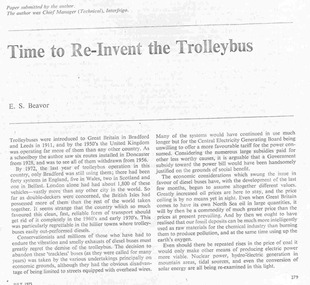
Document - Photocopy, "Time to Re-Invent the Trolleybus", 1980's?
Three page foolscap photocopy of an article titled "Time to Re-Invent the Trolleybus", stapled within a manila folder. Article on two pages, July 1975 issue of the Chartered Institute of Transport Journal and a page of letters concerning the article in the November 1975 issue. Article written by E. S. Beavor, written after the first oil price shock, looking at Battery supplemented trolley buses."Time to Re-Invent the Trolleybus" written on the outside of the folder.trams, tramways, trolley buses, public transport -
 Ballarat Tramway Museum
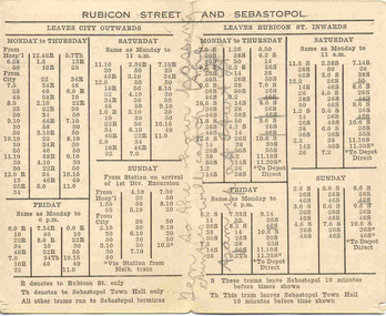
Ephemera - Timetable/s, Electric Supply Co. of Vic (ESCo), "Ballarat Tramways Rubicon Street and Sebastopol Time Table.", 1920's
Demonstrates aspects of the Ballarat Tramways in providing information to the travelling public about their tram services, times and how organised in relation to the time of the day. An ESCo era timetable. Two local businesses have advertised as well.Folded printed card, off white, titled "Ballarat Tramways Rubicon Street and Sebastopol Time Table." Gives details of trams from the City for Rubicon St and Sebastopol for the various days and inbound trams from Rubicon, indicating that trams ex Sebastopol ran 10 minutes earlier. Has various notes on the timetable. On Front of card, has advertisements for R. Hutchinson - 29 Armstrong St Ballarat, auto electrician and Suttons Ltd - Musical instruments - Corner Sturt and Dawson Streets. An ESCo produced timetable - 1920's, as the SECV used "Grey St" instead of Rubicon St. (Email from Alan Bradley 8/2006). Copy of email with worksheet.Pencil marks on the cover - about tram services etc. g "Ten to the hour Aunties will catch the tram up at Sturt St"timetables, sebastopol, rubicon st, r. hutchinson, suttons, esco -
 Ballarat Tramway Museum
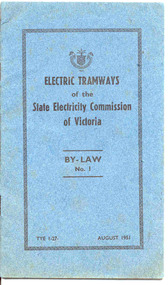
Book, State Electricity Commission of Victoria (SECV), "Electric Tramways of the State Electricity Commission of Victoria By-Law No. 1", 1951
Demonstrates aspects of the SEC governance system in issuing By-laws for the travelling public, as part of their Act. Yields information about fares charged for tram services in Ballarat, Bendigo and Geelong. Issued to crews.Twenty page booklet, plus medium weight card light blue colour covers centre stapled. Book cover has title "Electric Tramways of the State Electricity Commission of Victoria, By-Law No. 11". Along the bottom edge is the date, "August 1951" and SEC print number - "TYE 1-27" Pages are numbered pages 1 to 20. Document give by-laws and amends the fare schedules for Ballarat, Geelong and Bendigo. Dated by the SEC 19/7/1951 to come into effect 1/7/1951 Details names of SEC Commissioners on rear page. No printer details. See also Reg Item 3112 for other copies and a full pdf copy. 2nd copy added 17/1/2007. See Fares in Ballarat – from Alan Bradley 11/4/2005 – appendix for Book Fare schedules on pages 13 to 19 have been crossed out in blue ink., 2nd copy has "R. Courtney" in ink on front cover, no alterations to rest of the book.trams, tramways, secv rules, by laws, tickets, fares, ballarat, bendigo -
 Ballarat Tramway Museum
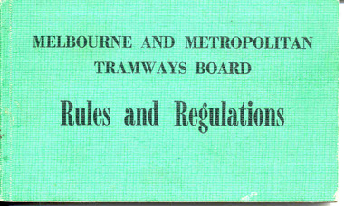
Book, Melbourne and Metropolitan Tramways Board (MMTB), "Melbourne and Metropolitan Tramways Board Rules and Regulations", Nov. 1974
Demonstrates the method that the MMTB used to inform its tram and bus crews of the organisational rules and regulations in respect to the operation of the public transport service in Melbourne - mid 1970's.Book with light green Rexene covers, slightly rounded corners, six sections, sewn with self end papers, 104 pages, excluding end papers. Details the MMTB Rules and Regulations relating to drivers, conductors and employees concerned in any aspect of electric tram and motor omnibus operations. Issued with date Nov. 1974. Full scan of document (difficult to do a proper scan) added 29/5/2019.trams, tramways, mmtb rules, rules, drivers, conductors, buses -
 Ballarat Tramway Museum
Document - Newsletter, Ballarat Tramway Preservation Society (BTPS), BTPS Information sheet, May. 1971
Has a strong association with the formation of the BTPS and the involvement of Melbourne based tramway enthusiasts - notes a Melbourne interim council and its work and a forthcoming meeting in Ballarat.Single page - foolscap size green coloured paper, printed using the Gestetner wax stencil process; titled "Information Sheet No. 1". gives details on the progress to operate the trams in Ballarat, a Melbourne Interim Council, SEC donation and that a public meeting to be held in Ballarat on 30th May with details of the trains. See Reg Item 3928 for a circular advertising a tram tour prior to the meeting. Details names of the Melbourne Interim Council persons. Second copy from donation of the Tom Murray Estate added 20-11-2016.trams, tramways, btps, meetings -
 Ballarat Tramway Museum
Document - Form/s, Ballarat Tramway Preservation Society (BTPS), Lake Wendouree Tram tour booking, May. 1971
Has a strong association with the formation of the BTPS and the way that support for the organisation was governed at the time - operation of tram tours. Has details of fares and times.Single page - quarto size pink coloured paper, printed using the Gestetner wax stencil process advertising a Lake Wendouree Tram tour on Sunday 30 May 1971, the day of a public meeting (see Reg. Item 3925). Gives times of tour, to inspect the Gardens area and proposed depot site and fares - 20cents. Has a tear off section to book.trams, tramways, btps, meetings -
 Ballarat Tramway Museum
Administrative Record - Meeting Minutes, Ballarat Tramway Preservation Society (BTPS), "A Historical Tramway for Ballarat", 1971
Printed sheet detailing the vision of a historic or heritage tramway for Ballarat around Lake Wendouree and personal notes of one of the attendees of the meeting.3932.1 - duplicated set of meeting ( 3 pages 2 sheets) notes titled "A Historical Tramway for Ballarat", prepared for the public meeting at the VRI on 29/4/1971. Printed using the Gestetner duplicating process on foolscap paper in green ink, giving a back ground to the proposal for a heritage or historical tramway in Ballarat, a vision, the benefits of Ballarat, Agenda for the meeting, request for donations and draft resolutions. Graeme Breydon has written notes on pages 2 and 3 of the notes, including additional resolutions, changes to the resolutions and the people who made up the Committee. Prepared by Bill Jessup, Donald Fraser, Paul Nicholson and Frank Stamford. 3932.2 - meeting notes and attendees (some), including a map, notes Brown Hill and various comments of people. For original copy, see Reg Item 4252, item 81. 3932.1 - 2nd copy added 26/8/12, from Richard Gilbert Collection - each sheet scanned and added to the image file. On the rear of the copy has a list of 13 names and a date for a meeting (Thurs 6, at 8pm) (The Committee formed) and on bottom of page 3, notes on additional track to be retained. 3932.1 - third copy from donation of the Tom Murray Estate added 25-11-2016 - in unmarked condition. trams, tramways, closure, preservation, ballarat, btps -
 Ballarat Tramway Museum
Administrative Record - Meeting Minutes, Lake Wendouree Tramway Museum Committee, "Lake Wendouree Tramway Museum Committee", Apr. 1971
Printed notes following a meeting that formed the Lake Wendouree Tramway Museum Committee - Brown Hill Progress Association.Duplicated sheet of Foolscap paper, detailing the formation of the "Lake Wendouree Tramway Museum Committee", the Convenors (Brown Hill Progress Association), Objects, Proposals that were adopted at the public meeting of 18/4/1971 and an interim executive. See also Reg item 910 for other associated papers. Two copies heldtrams, tramways, btps, preservation, brown hill progress association -
 Ballarat Tramway Museum
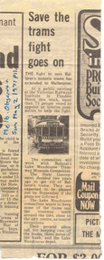
Newspaper, Melbourne Observer, "Save the trams fight goes on", 2/05/1971 12:00:00 AM
Demonstrates the type of publicity the moves to establish a heritage tramway in Ballarat was obtaining in Melbourne at the time.Newspaper clipping from Melbourne Observer, Sunday, 2 May 1971, page 11, titled "Save the trams fight goes on". Item written following the public meeting at the VRI on 29 April (See Reg Item 3932.1 and other papers). Reported that more than 75 people attended, that the committee will work with the Lake Wendouree Tramway Museum Committee.On the side of the cutting in blue ink "Melb Observer / Sun May 2 1971 p11."ballarat, btps, preservation -
 Ballarat Tramway Museum
Literary work - Manuscript, Kevin Tierney, "Essay - abandonment of the Ballarat Tramway System", 1972
Has a strong association with the author who was interested in public transport and chose to write an economic history essay about the close of the Ballarat Tramway system and its substitution by buses and whether they should be government operated.Fifteen, lined or ruled foolscap page manuscript / Essay for a Melbourne University Economic History subject, 1972, written Kevin Tierney about the abandonment of the Ballarat Tramway System. Has a Synopsis, references and quotations from various sources. The question to be answered was "Should the electric tramways at present operated by the State Electricity Commission in the provincial centre of Ballarat be abandoned and if so, should public ownership be retained for the replacement system?" A photocopy on A4 paper was also donated by the author. Also donated two postcards with trams - Bendigo - line up of five Birney trams and H class 357 and 358 in Jetty Road Glenelg - see image files, providing information about the essay and contacts.trams, tramways, closure, ballarat, sec, buses