Showing 1743 items matching "railway house"
-
 Lorne Historical Society
Pamphlet - Tourist pamphlet Lorne, Lorne Victoria Australia
Victorian Railways printed a series of brochures publicizing holiday destinations.A folded paper souvenir pamphlet. The cover is a colored picture of Lorne from Scotsman’s Hill with two bathing suited young women in the foreground, and a blurb extolling the virtues of Lorne. On the back is a red, yellow and blue map of Lorne and district. Inside are eight black and white photographs of Lorne attractions,; the Main Street, tennis courts, Erskine River, walking tracks and the George River with the phrase ,” The resort that embraces everything for the perfect holiday.”souvenirs, pamphlets, victorian railways, -
 Greensborough Historical Society
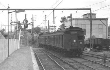
Photograph - Digital Image, Paul de Sauty, Tait 'red rattler' at Greensborough Railway Station 1960s, 1960s
Photograph of a Tait ' red rattler' (with sliding door) at Greensborough Railway Station in the 1960s. In the background are coal trucks in the siding, the station master's house, and under the train is the foot crossing, prior to the overpass.Digital copy of black and white photograph.greensborough railway station, trains -
 Greensborough Historical Society
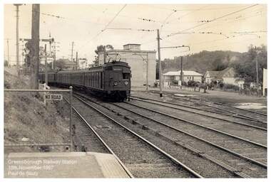
Photograph - Digital Image, Paul de Sauty, Greensborough Railway Station 1967, 18/11/1967
Photograph of train at Greensborough Railway Station in 1967. In the background are the station master's house behind the train, with the Higgins and Leaford houses in back right.Digital copy of black and white photograph.greensborough railway station, trains -
 Greensborough Historical Society
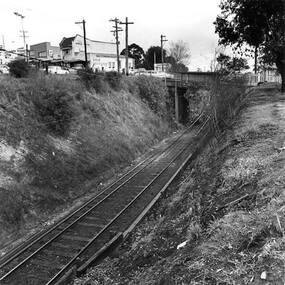
Photograph - Digital Image, Single train track in the cutting at Greensborough 1970s, 1970s
Photograph of the single track approaching Greensborough Railway Station in the 1970s. This view is from behind the station master's house. On the hill to the left is Connie Burkett's hair salon in the Valley Buildings.Digital copy of black and white photograph.greensborough railway station, trains, main street greensborough, connie burkett -
 Greensborough Historical Society
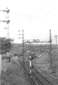
Photograph - Digital Image, Gantries and electricals, Greensborough Station 1970, 1970_
Photograph of construction of the new station at Greensborough. This shows gantries and overhead electricals. The photo is taken from the station master's house looking toward the station and sidings. The new station was opened on 03/04/1970.Digital copy of black and white photograph. trains, greensborough railway station -
Glenelg Shire Council Cultural Collection
Photograph - Photograph - Public Baths, Portland, 1930s
Black and white photo, white border. View of the baths, Ocean Pier, Railway Pier with steamer at berth. Fishermen's Breakwater, Battery Point in background. Taken from ground level, looking east.'THE PIERS AND BATTERY POINT PORTLAND', black print, lower borderphotography, portland baths, pier, battery point, portland, fishermans breakwater -
Glenelg Shire Council Cultural Collection
Photograph - Photograph - view of Henty's Beach, Portland, 1930s
Black and white photo, white border. View of Henty Beach Portland, looking north to water tower, Whaler's Bluff, spire of the All Saints Catholic Church. Cars on beach in foreground, numerous people on sand / in water, Railway Pier and Baths visiblephotography, henty beach, portland, whalers bluff -
Glenelg Shire Council Cultural Collection
Administrative record - Ticket, n.d
Victorian Railways cloakroom ticket, green and buff, heavy card, black print. No. 0135 Terang.victorian railways, ticket, terang -
Glenelg Shire Council Cultural Collection
Postcard - Postcard - Portland Harbour, 1930s
Owned by James and Ada Brimblecomber, Heywood, and then by Merle Lewis, Mt. Gambier.Black and white photographic image of a harbour with two long piers running into it and a shorter jetty with a building on it and a circular jetting protruding from it. In the foreground are trees, a dirt road with an RACV sign bridging it to the right and a railway track visible between the trees.Front: THE HARBOUR, PORTLAND (printed, lower centre) -
 Glenelg Shire Council Cultural Collection
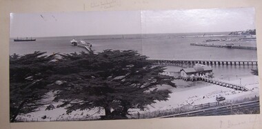
Postcard - Postcard - Portland Harbour, n.d
Black and white photo - 2 photos joined together. Ship on left. Ship at Pier. Fishermans wharf. Railway pier. Long pier. 3rd baths in foreground. Van on road below cliff. 2 cypress trees in foreground. 2 people on beach.fishermens wharf, portland baths, railway pier, portland harbour -
Glenelg Shire Council Cultural Collection
Photograph - Photograph - Portland Harbour, 1930s
Black and white photo, white border. View of the Harbour, Portland, from clifftop, looking east. Baths, Ocean Pier, Railway Pier, Fishermen's Breakwater, Battery Point in background. 'THE HARBOUR, PORTLAND', black print, lower border -
Glenelg Shire Council Cultural Collection
Photograph - Photograph - Aerial view from the N.W. of Portland Harbour under construction, c. 1950
Port of Portland Authority archives.Front: (no inscriptions) Back: (no inscriptions)port of portland archives -
Glenelg Shire Council Cultural Collection
Booklet - Booklet - Hotel and Guesthouse Guide, c. 1950
Promotional booklet 'Where to go in Victoria (Hotel and Guesthouse Guide) produced by the Vic Govt, printed and published by the Victorian Railways Advertising Division and Printing Works. Print and pictures in black and white -
Glenelg Shire Council Cultural Collection
Photograph - Photograph - Aerial photograph of Portland harbour taken from the north east, 1967
Front: (no inscriptions) Back: Portland Harbour 1967/ No 6 berth under construction (ocean pier and railway pier still in existence)port of portland archives -
Glenelg Shire Council Cultural Collection
Photograph - Photograph - Aerial view from NE Portland Harbour, c. 1967
Port of Portland Authority archives.Front: 19 June 1997 Back: 19 June 1997port of portland archives -
 Glenelg Shire Council Cultural Collection
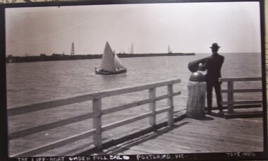
Photograph - Photograph - Portland Lifeboat under full sail, n.d
Displayed at History House.Long pier in background. Man with megaphone on end of Railway pier. Portland Lifeboat under full sail. Rails at end of pier.Front: The Lifeboat under Full Sail - Portland, Vic. Back: Sticker - history House. Copy purchased in March 1989. From Mr. Stafford. Photographer Julia Streetportland lifeboat, lifeboat crew, vessel -
Glenelg Shire Council Cultural Collection
Photograph - Photograph - View of Portland and foreshore, 21/03/1972
Port of Portland Authority archives.Front: (no inscriptions) Back: (no inscriptions)port of portland archives -
Glenelg Shire Council Cultural Collection
Photograph - Photograph - Early Shipping: Ocean / Railway Pier, c. 1990
Port of Portland Authority archives.Front: PORTLAND PIER 87port of portland archives -
Glenelg Shire Council Cultural Collection
Photograph - Photograph - Early Shipping: Ocean / Railway Pier, n.d
Port of Portland Authority archives.port of portland archives -
![Photograph - Digital image, Greensborough Railway Station [2], 1930-1940](/media/collectors/4f729f5697f83e03086015b8/items/54435c822162f10ea4a1fd2b/item-media/54435ca72162f10ea4a1fe4b/item-fit-380x285.jpg) Greensborough Historical Society
Greensborough Historical SocietyPhotograph - Digital image, Greensborough Railway Station [2], 1930-1940
Photograph of Greensborough Railway Station, early 20th century, showing train and group of young people on platform. A car parked outside the Roy House on Main Street Greensborough [opposite the future entrance to the Greensborough Plaza] This photo is from the Lorraine Coates Collection.An early photograph of Greensborough Station.Digital copy of black and white photograph.greensborough station -
 Greensborough Historical Society
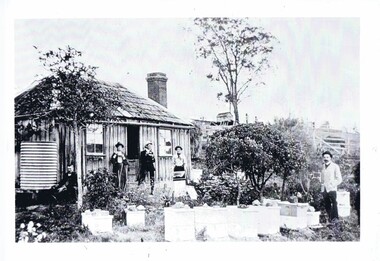
Photograph, Home of Mr Coghill Greensborough, 1910c
... house located between the railway line and the Plenty River... was the former Mitchell house located between the railway line ...Shows the home of Mr Coghill which was the former Mitchell house located between the railway line and the Plenty River and directly opposite the end of Jessop Street.This shows the type of dwelling the early settlers lived in, also what they had in their cottage gardens.A rectangular black and white photograph of 4 men and 1 woman in a garden outside a shingle hut with bee hives near them.shingle hut, cottage garden, bee hives, coghill, mitchell, 1910 -
 Greensborough Historical Society
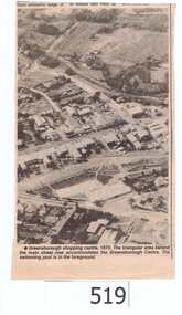
Newspaper clipping, Greensborough shopping centre 1970, 1970_
The photograph is of the centre of Greensborough in 1970, prior to the Greensborough Plaza being built. The Partington farm house, named 'Alwyn' (after Alan and Wyn Partington) can be seen north of the Railway Line. Alan and Wyn had to leave this farm in 1976 - moving to a new house - built by son Gary - at 54 Manatunga Circuit - to make way for the creation of Whatmough Park and development of the Hailes Street-The Circuit-Greensborough Plaza precinct.This is an important visual record of Greensborough before the redevelopment of the late 1970's. It also shows the Whatmough park area when it was still the Partington family farm.A black and white newspaper clipping featuring an aerial photograph.Nilgreensborough streets, greensborough, aerial photograph, 1970, partington, whatmough park, greensborough swimming pool -
 Greensborough Historical Society
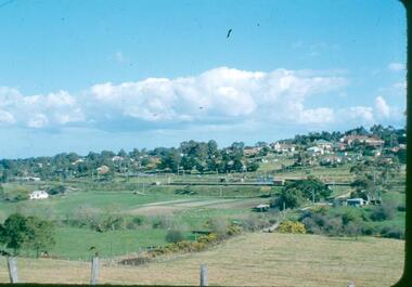
Photograph - Digital image, Frank Robinson, Looking south east from Pope's paddock to the railway line, 1954_
Looking south east from Pope's paddock to the railway line. The Blackjack property, house and acres of fruit orchards ran down to the Plenty River off Hume Street Greensborough and was the home of the Robinson family to late 1956. The photographs were taken as slides by Frank Robinson and digitised by his son James in 2015.Digital copy of colour photograph.robinson family, popes paddock -
 Glenelg Shire Council Cultural Collection
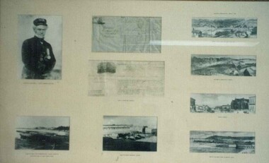
Photograph - Photograph - framed collection of photographs and shipping certificates, n.d
UnknownFramed collection of photographs and shipping certificates in brown timber frame, under glass. 1. Captain Fawthrop; 2. lighter; 3. Henty's pier and original baths; 4. Baths, railway pier, Henty's jetty; 5. Percy St; 6. Railway & Bentinck St; 7. North Portland Railway Station; 8 & 9. 'Shipped' certificates.Front: Captain Fawthrop 'Shipped' certficates Lighter/ Henty's pier and originall baths/ Baths, railway pier, Henty's jetty/ Percy St/ Railway & Bentinck St/ North Portland Railway Station/ Back: (no inscriptions)captain fawthrop, lighter, hentys pier, original baths, baths, railway pier, hentys jetty, percy st, railway and bentinck st, north portland railway station, shipped certificates -
 Glenelg Shire Council Cultural Collection
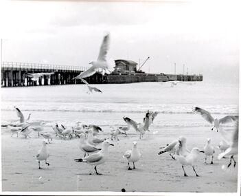
Photograph - Photograph - Railway Pier Portland, n.d
Con Kroker CollectionBlack & white photo of Railway Pier, taken from henty Beach. Flock of seagulls in foreground -
 Glenelg Shire Council Cultural Collection
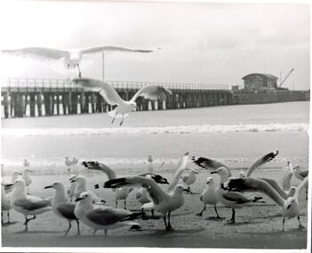
Photograph - Photograph - Railway Pier Portland, n.d
Con Kroker CollectionBlack & white photo of Railway Pier, taken from Henty Beach. Flock of seagulls in foreground. NB Same subject matter as 5005, but a bit closer to subject. -
Glenelg Shire Council Cultural Collection
Slide - Slide - Henty Beach, Portland, Portland Bay, 1960s
Taken by Mr P.G.W. (Wal) Whitelaw in early to mid 1960'sAlfacolour Slide of Henty Beach, Portland bay Paddle Boats on sand on left. Boatrs at anchor & Railway pier in background.slide, colour, henty beach, railway pier -
Glenelg Shire Council Cultural Collection
Slide - Slide - Henty Beach, Portland, PORTLAND BAY, 1960s
Taken by Mr. P.G.W. (Wal) Whitelam in the early to mid 1960'sAlfacolor Slide of Henty Beach, Portland Bay. Paddle Boats on sand on left. Left side cars in carpark. Moored boats & Railway Pier in background.Front: Portland Bay Vi , blue birophotography, slide, 1960s, henty beach, railway pier, portland -
 Glenelg Shire Council Cultural Collection
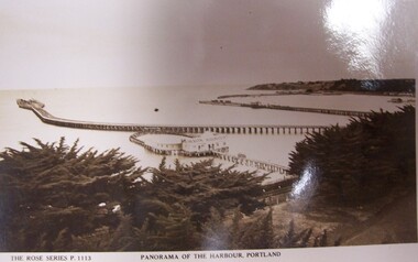
Postcard - Postcard - Panorama of Portland Harbour, n.d
Black and white photographic image of a harbour with two long piers running into it and a shorter jetty with a building on it and circular jetty protruding from it. In the foreground are trees, a dirt road to the foreground right and a railway track visible between the trees.Front: THE ROSE SERIES P. 1113/ COPYRIGHT (typed, lower left) PANORAMA OF THE HARBOUR, PORTLAND (typed, lower centre) Back: (no incriptions) -
 Glenelg Shire Council Cultural Collection
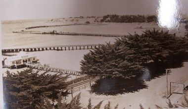
Postcard - Postcard - The Harbour, Portland, n.d
Black and white photographic image of a harbour with two long piers running into it and a shorter jetty with a building on it and circular jetty protruding from it. In the foreground are trees, a dirt road with an RACV sign bridging it to the foreground right and a railway track visible between the trees.Front: THE ROSE SERIES P. 10771/ COPYRIGHT (typed, lower left) THE HARBOUR, PORTLAND (typed, lower centre)