Showing 634 items matching "river view"
-
 Mission to Seafarers Victoria
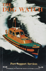
Journal (item) - Periodicals-Annual, Shiplovers' Society of Victoria, The Annual Dog Watch
This journal provides the reader with glimpses of the adventures and hardships of a seaman's life. Many of the stories are of sailing ships.Contributes to our knowledge of the importance of shipping and places on record those stories of the sea which would otherwise be lost.Contents Editorial - Fifty Years Past - Miss S.A.E. Strom - 5 The Port of Melbourne — A Historical View - Andy Gash - 8 We Moved the Cargoes - J. Beggs - 15 A Chaplain’s Chatterings - W.S. McUtchen - 19 Pilots - Late C.E. Borwick - 26 Up the River — Down the River - Lloyd Taylor - 27 Port Services in the Nineteenth Century - M.A. Syme - 45 The Schooner Enterprise - Roy Stuart - Roy Stuart - 49 The Port Phillip Sea Pilot Service - Capt. Michael Carolin - 53 Streamers - G.M. Naug - 60 Errata - - 60 War Diary of H.M.A.S. Bendigo Part 2 1942 - T.W. Richardson - 61 Fire Fighting Services in the Port of Melbourne - Frank M. Stockton - 75 Shipwreck - A. Roland Jones - 81 The Diary of Peter Charles Iredale - Colin Wilson - 87 The John Oxley - R.N. Thiele - 95 The Volunteer - Bert Attwood - 100 Sailing in Wharanui - W.P. Shemmeld - 101 Book Reviews - - 110 The Most Fascinating Immigrant — Marco Polo - K. Shewan - 111sailing ships, steamships, shipping, seafaring life, shiplovers' society of victoria, dog watch -
 Greensborough Historical Society
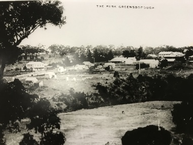
Photograph, The Park Greensborough, 1900c
View of Greensborough Park from Partington's Hill, showing sporting ground, Plenty River, Marble Hall, sparse housing on north side of Main Road, the Farmers' Arms hotel, the Rechabite Hall and Main Road bridge over the the railway line. Marble Hall is the double-storied building on the corner of Main Road.Part of a collection of 5 enlarged photographs dating from the early 1900s.Black and white enlargement of photographgreensborough park, main street greensborough, rechabite hall, farmers' arms hotel, marble hall, greensborough railway -
 Greensborough Historical Society
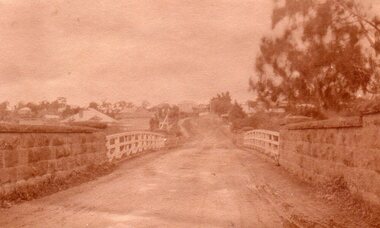
Photograph, Main Road bridge looking to township of Greensborough, 1929c
View of Main Street Greensborough from Partington's Hill including Plenty River bridge and Marble Hall on corner of Carter Street (now Para Road) and Main Street. This view of Greensborough Park shows the old pan toilets, the hawthorn fence line and the rather undeveloped roadside area of the park. Looking up Main Street we see the old Chapman house at the corner of Poulter Avenue and some newer houses below this. The stone river bridge appears to be only a single lane wide and the road approaching the bridge is unsealed. The rail bridge shows evidence of soot from steam trains and at the extreme left of picture the two concrete buildings indicate the line had been electrified. This occurred in 1923. Sparse housing is seen in the Flintoff Street and Grimshaw Street area.Part of a collection of photographic enlargements of views of Greensborough in the early 1900s.Black and white enlargement of photographic imagemain street greensborough, marble hall, greensborough railway, chapman house, greensborough park, poulter avenue greensborough, carter street, para road -
 Glenelg Shire Council Cultural Collection
Painting, George H.L Pentland, Casterton 1889, 1889
Casterton & District Historical Society Inc.Painting, oil on canvas showing a 'bird's-eye' view' of the township of Casterton in the late 19th century. It shows the Glenelg River, the bridge, main street and rolling landscape of the Western District.casterton, oil painting, landscape -
 Greensborough Historical Society
Photograph - Digital image, Main Street Bridge Greensborough, 1910c
View of bridge over Plenty River at Greensborough. Photographs from the collection of Peter Blackbourn, a descendant of the Chapman Stock family. Annotations to photos by Peter Blackbourn.Digital copy of black and white or sepia photograph.peter blackbourn, main street greensborough, bluestone bridge -
![Photograph - Digital image, House St Helena and Diamond Creek Roads [Greensborough], 02/05/2013](/media/collectors/4f729f5697f83e03086015b8/items/5729bbd22162f108e8de5be2/item-media/5729bc112162f108e8de617d/item-fit-380x285.jpg) Greensborough Historical Society
Greensborough Historical SocietyPhotograph - Digital image, House St Helena and Diamond Creek Roads [Greensborough], 02/05/2013
These photographs of the house on the corner of St Helena and Diamond Creek Roads was taken in 2013 to show changes over 40 years, based on Ron Reynold's sketches in the 1973 publication 'Greensborough and Greenhills' published by Cypress Books... which states "Built on a steep hill in a bush setting in the early 1920s, for a Dr Wood, the weatherboard house now overlooks an area of activity and change. The owners, Mr and Mrs E. 'Bluey' Blackburn, remember when their 3/4 acre building block dropped to the edge of a dirt road. Today the view from the high verandah encompasses the Main Street shopping centre, new and old bridges, new roads and houses, the Plenty River, natural bush, hills and sports grounds."Digital copy of colour photograph.greensborough and greenhills, st helena road greensborough, diamond creek road greensborough, wood family, ron reynolds -
 Greensborough Historical Society
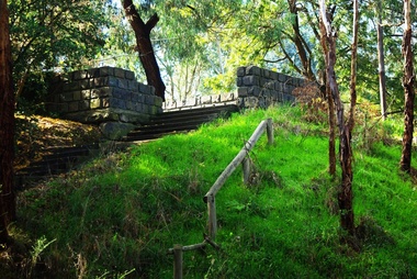
Photograph - Digital Image, Pioneer Reserve 2014 -1, 21/05/2014
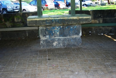
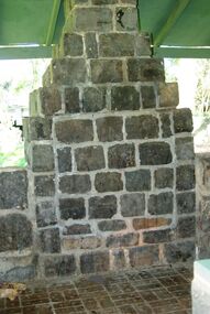
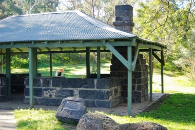
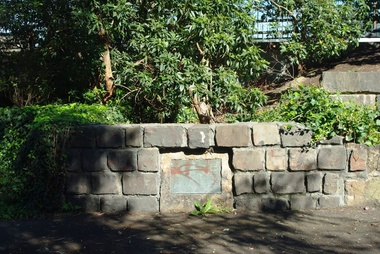
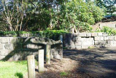
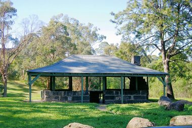
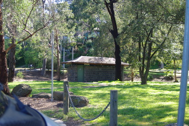
Pioneer Reserve, Greensborough is a small park on the corner of St Helena and Diamond Creek Roads. It is adjacent to the site of Greensborough's first bridge across the Plenty River, c. 1864 - 1960s. The shelter, viewing platform, retaining wall and entrance are built from the bridge's massive bluestone arched abutments dismantled between 1974 and 1983. Pioneer Reserve is historically significant for its formative association with noted local landscape designer Gordon Ford in 1968, and it is likely that remnant large field stones at the entrance drive to the Reserve remain from his design. Photograph by Marilyn Smith 2014.Digital copy of colour photograph. -
 Greensborough Historical Society
Photograph - Digital Image, Pioneer Reserve 2014 -2, 01/10/2014
Pioneer Reserve, Greensborough is a small park on the corner of St Helena and Diamond Creek Roads. It is adjacent to the site of Greensborough's first bridge across the Plenty River, c. 1864 - 1960s. The shelter, viewing platform, retaining wall and entrance are built from the bridge's massive bluestone arched abutments dismantled between 1974 and 1983. Photograph by Marilyn Smith 2014.Digital copy of colour photograph.pioneer reserve greensborough -
 Greensborough Historical Society
Photograph - Digital Image, Pioneer Reserve 2014 -3, 01/10/2014
Pioneer Reserve, Greensborough is a small park on the corner of St Helena and Diamond Creek Roads. It is adjacent to the site of Greensborough's first bridge across the Plenty River, c. 1864 - 1960s. The shelter, viewing platform, retaining wall and entrance are built from the bridge's massive bluestone arched abutments dismantled between 1974 and 1983. Photograph by Marilyn Smith 2014.Digital copy of colour photograph.pioneer reserve greensborough -
 Greensborough Historical Society
Photograph - Digital Image, Pioneer Reserve 2014 -4, 23/09/2014
Pioneer Reserve, Greensborough is a small park on the corner of St Helena and Diamond Creek Roads. It is adjacent to the site of Greensborough's first bridge across the Plenty River, c. 1864 - 1960s. The shelter, viewing platform, retaining wall and entrance are built from the bridge's massive bluestone arched abutments dismantled between 1974 and 1983. Photograph by Marilyn Smith 2014.Digital copy of colour photograph.pioneer reserve greensborough -
 Greensborough Historical Society
Photograph - Digital Image, Pioneer Reserve 2014 -5, 23/09/2014
Pioneer Reserve, Greensborough is a small park on the corner of St Helena and Diamond Creek Roads. It is adjacent to the site of Greensborough's first bridge across the Plenty River, c. 1864 - 1960s. The shelter, viewing platform, retaining wall and entrance are built from the bridge's massive bluestone arched abutments dismantled between 1974 and 1983. Photograph by Marilyn Smith 2014.Digital copy of colour photograph.pioneer reserve greensborough -
 Greensborough Historical Society
Photograph - Digital Image, Pioneer Reserve 2014 -6, 23/09/2014
Pioneer Reserve, Greensborough is a small park on the corner of St Helena and Diamond Creek Roads. It is adjacent to the site of Greensborough's first bridge across the Plenty River, c. 1864 - 1960s. The shelter, viewing platform, retaining wall and entrance are built from the bridge's massive bluestone arched abutments dismantled between 1974 and 1983. Photograph by Marilyn Smith 2014.Digital copy of colour photograph.pioneer reserve greensborough -
 Greensborough Historical Society
Photograph - Digital Image, Pioneer Reserve 2014, 23/09/2014
Pioneer Reserve, Greensborough is a small park on the corner of St Helena and Diamond Creek Roads. It is adjacent to the site of Greensborough's first bridge across the Plenty River, c. 1864 - 1960s. The shelter, viewing platform, retaining wall and entrance are built from the bridge's massive bluestone arched abutments dismantled between 1974 and 1983. Photograph by Marilyn Smith 2014.Digital copy of colour photograph.pioneer reserve greensborough -
 Greensborough Historical Society
Photograph - Digital Image, Pioneer Reserve 2014 -8, 23/09/2014
Pioneer Reserve, Greensborough is a small park on the corner of St Helena and Diamond Creek Roads. It is adjacent to the site of Greensborough's first bridge across the Plenty River, c. 1864 - 1960s. The shelter, viewing platform, retaining wall and entrance are built from the bridge's massive bluestone arched abutments dismantled between 1974 and 1983. Photograph by Marilyn Smith 2014.Digital copy of colour photograph.pioneer reserve greensborough -
 Greensborough Historical Society
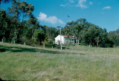
Photograph - Digital Image, View of Greensborough near Blackjack, 1954_
View of Greensborough near Blackjack. The Blackjack property, house and acres of fruit orchards ran down to the Plenty River off Hume Street Greensborough and was the home of the Robinson family to late 1956. The photographs were taken as slides by Frank Robinson and digitised by his son James in 2015.Digital copy of colour photograph.robinson family, blackjack -
 Greensborough Historical Society
Photograph - Digital Image, View of Blackjack near Greensborough, 1954_
View of Blackjack near Greensborough. The Blackjack property, house and acres of fruit orchards ran down to the Plenty River off Hume Street Greensborough and was the home of the Robinson family to late 1956. The photographs were taken as slides by Frank Robinson and digitised by his son James in 2015.Digital copy of colour photograph.robinson family, blackjack -
 Greensborough Historical Society
Photograph - Digital image, Marilyn Smith et al, Janefield Precinct view November 2014, 27/11/2014
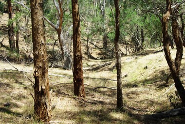
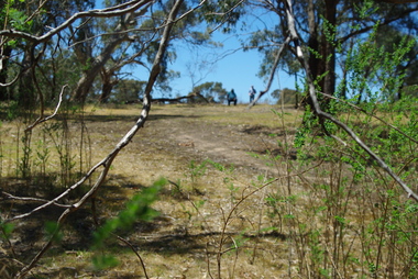
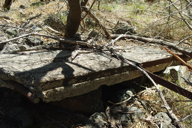
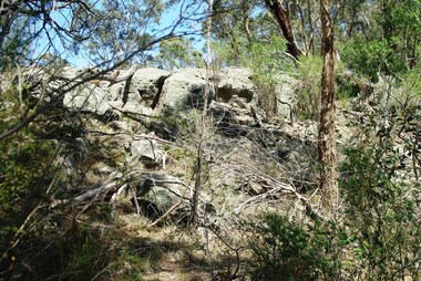
View of the Janefield Precinct taken November 2014. The remains of this site are between Greensborough and Janefield. A RAAF Hygiene Training Camp was located on the Plenty River, just south of the Janefield community. It was in use from 1944 to 1946. The Camp was constructed from salvaged materials. Instruction included building and maintenance of grease traps, latrines, elementary plumbing and carpentry.Early remains of a WW2 training campDigital colour photograph.janefield, raaf hygiene training camp janefield -
 Greensborough Historical Society
Photograph - Digital image, Marilyn Smith et al, Janefield Precinct: more pondering - Janefield view, 27/11/2014
More pondering - Janefield view. The remains of this site are between Greensborough and Janefield. A RAAF Hygiene Training Camp was located on the Plenty River, just south of the Janefield community. It was in use from 1944 to 1946. The Camp was constructed from salvaged materials. Instruction included building and maintenance of grease traps, latrines, elementary plumbing and carpentry.Early remains of a WW2 training camp Digital colour photograph. -
 Greensborough Historical Society
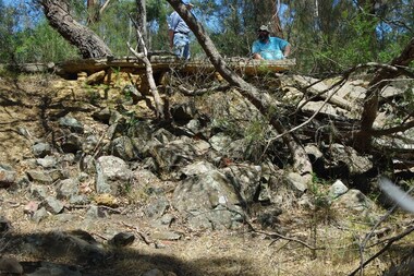
Photograph - Digital image, Marilyn Smith et al, Janefield Precinct: Side view showing reinforcements, 27/11/2014
Janefield Precinct: Side view showing reinforcements. The remains of this site are between Greensborough and Janefield. A RAAF Hygiene Training Camp was located on the Plenty River, just south of the Janefield community. It was in use from 1944 to 1946. The Camp was constructed from salvaged materials. Instruction included building and maintenance of grease traps, latrines, elementary plumbing and carpentry.Early remains of a WW2 training camp Digital colour photograph. -
 Greensborough Historical Society
Photograph - Digital image, Marilyn Smith et al, Janefield Precinct: View of edge of basalt flow, 27/11/2014
Janefield Precinct: View of edge of basalt flow. The remains of this site are between Greensborough and Janefield. A RAAF Hygiene Training Camp was located on the Plenty River, just south of the Janefield community. It was in use from 1944 to 1946. The Camp was constructed from salvaged materials. Instruction included building and maintenance of grease traps, latrines, elementary plumbing and carpentry.Early remains of a WW2 training camp Digital colour photograph.janefield -
 Greensborough Historical Society
Photograph - Digital image, Marilyn Smith et al, Janefield Precinct: View of slab from below showing formwork marks, 27/11/2014
Janefield Precinct: View of slab from below showing formwork marks. The remains of this site are between Greensborough and Janefield. A RAAF Hygiene Training Camp was located on the Plenty River, just south of the Janefield community. It was in use from 1944 to 1946. The Camp was constructed from salvaged materials. Instruction included building and maintenance of grease traps, latrines, elementary plumbing and carpentry.Early remains of a WW2 training camp Digital colour photograph.janefield -
 Greensborough Historical Society
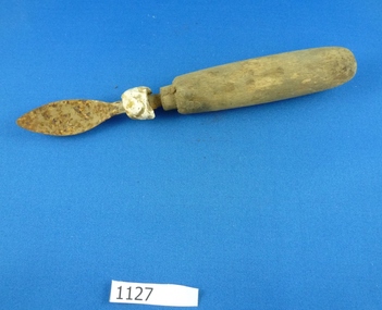
Spoon, 1899c
Metal spoon with timber handle, found along Plenty River near Yallambie circa 2005. [View advertisement in The Weekly Times Saturday 12 August 1899, page 32]Spoon with pointed bowl, timber handle and bone on shaft. Some rust.spoons, plenty river, yallambie -
![Photograph - Digital image, Willis Vale [2], 1950c](/media/collectors/4f729f5697f83e03086015b8/items/54fd41442162f10d30bf885f/item-media/54fd41912162f10d30bf8caa/item-fit-380x285.jpg) Greensborough Historical Society
Greensborough Historical SocietyPhotograph - Digital image, Willis Vale [2], 1950c
View of Greensborough in the distance from Willis Vale and surrounding land: House built by Edward Maygar, The flowering Hawthorne Bushes were planted by William Partington. Note the prominent house on upper right where Robert Whatmough lived in the mid 19th century and later sold to Partington family. It was located on the Plenty River across from Partington's Flat. The derelict Willis Vale house was destroyed in 1964 when a fire originating from North Plenty Gorge - Kurrak Road - was lit by two teenage boys and made its way several kilometres down to Partington's Flat Greensborough. In 1946, Alan Partington built the Alwyn Farmhouse in place of the original Robert Whatmough home seen in this photo which became Whatmough Park circa 1976.Home of the Partington familyDigital copy of black and white photograph.willis vale, partington family, maygar family, whatmough -
 Greensborough Historical Society
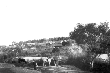
Photograph - Digital Image, View of Greensborough from Willis Vale, 1906_
View of Greensborough from Willis Vale. The people in the photograph were visitors and not identified. Willis Vale: House built by Edward Maygar, Robert Whatmough lived there mid 19th century and later sold to Partington family. It was located on the Plenty River at Partington's Flat Greensborough. Land use included farming and orchards. The derelict Willis Vale house was destroyed in 1964 when a fire originating from North Plenty Gorge - Kurrak Road - was lit by two teenage boys and made its way several kilometres down to Partington's Flat Greensborough. [Ellen died on 13/10/1903 - Some think this photo is thought to have been taken shortly after, at her funeral.]Digital copy of black and white photograph.willis vale, greensborough, partington family -
![Photograph - Digital image, Willis Vale [side view], 1950c](/media/collectors/4f729f5697f83e03086015b8/items/5502a2592162f11024c32328/item-media/5502a2852162f11024c3268d/item-fit-380x285.jpg) Greensborough Historical Society
Greensborough Historical SocietyPhotograph - Digital image, Willis Vale [side view], 1950c
Willis Vale: House built by Edward Maygar, Robert Whatmough lived there mid 19th century and later sold to Partington family. It was located on the Plenty River at Partington's Flat Greensborough. Land use included farming and orchards. The derelict Willis Vale house was vandalized in 1964 and destroyed when a fire originating from North Plenty Gorge - Kurrak Road - was lit by two teenage boys and made its way several kilometres down to Partington's Flat Greensborough. This photo was taken after the Partington's moved house in 1947. across the river where Alan built their new Alwyn house that had access to electricity. Home of the Partington family Home of the Partington familyDigital copy of black and white photograph.willis vale, partington, whatmough, maygar -
 Greensborough Historical Society
Folder (article and photographs), Greensborough Pool in the Plenty River / compiled by Marilyn Smith, 1937o
Society member Marilyn Smith has compiled a collection of historic articles from local newspapers, historic and modern photographs of the swimming pool in the Plenty River Greensborough, opened in 1937. The Pool is still visible from the Main Street bridge and present day photographs are also included. A short story by Gary Partington tells of his memories of the Plenty River as he was growing up.An historical view of the Greensborough pool in the Plenty River.Folder with pink plastic cover. 12 pages of text and photographs.plenty river, greensborough swimming pool, marilyn smith, gary partington -
 Greensborough Historical Society
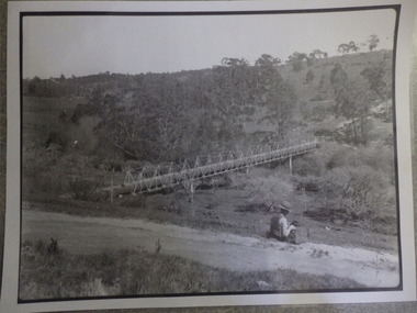
Photograph (copy), Aqueduct over the Plenty River / photographer unknown, 1920c
View of the Maroondah Aqueduct where it crosses the Plenty River in Greensborough.Black and white photograph, enlarged and laminated.maroondah aqueduct, plenty river -
 Greensborough Historical Society
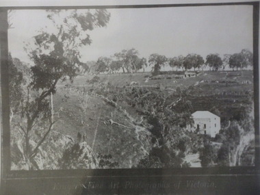
Photograph (copy), Fred Kruger, On the Plenty River near Bundoora / photograph by Fred Kruger, 1877c
View of farm land and mill on the Plenty River near Bundoora, circa 1877; photograph by Fred Kruger. Original held at SLV (accession # H473 and Image # a53840)Black and white photograph, enlarged and laminated.fred kruger, plenty river -
 Greensborough Historical Society
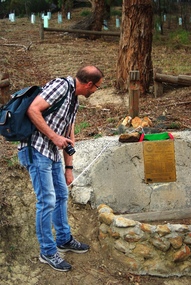
Photograph - Digital image, Marilyn Smith, Unveiling of new plaque at the Pioneer Children's Cemetery, April 2016, 02/04/2016
On 02/04/2016, Greensborough Rotary and Greensborough Hstorical Society members gathered to unveil an updated plaque at the Pioneer Children's Cemetery on the Plenty River. These photos show the new plaque and Steve Whatmough viewing the plaque. Steve is a descendant of the Whatmough family whose children, with their cousins the Partingtons, were buried in this place. More photos of this event can be found at the GHS Resource Centre. Digital copy of colour photograph.greensborough historical society, pioneer childrens cemetery, steve whatmough, rotary club of greensborough -
 Greensborough Historical Society
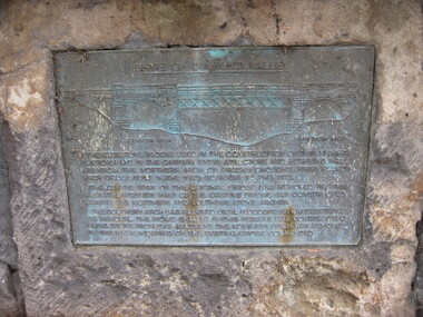
Photograph - Digital image, Dennis Ward, Bridge Plaque - Pioneer Park Greensborough, 27/03/2010
Plaque at Pioneer Reserve Greensborough: "Shire of Diamond Valley. The bluestones used in the construction of this viewing platform and in the carpark entry structure and retaining wall are from the northern arch of Greensborough's first Plenty River Bridge built in the 1860s adjacent to this site. The centre span of the original bridge was removed in 1865 when the western half of the existing bridge was constructed leaving the northern and southern stone arches. The southern arch was retained until floods in 1874 necessitated its removal. The picnic shelter in this reserve was constructed using stone from this abutment. The northern arch was removed in 1983 when widening of the existing bridge commenced."Digital copy of colour photograph.plenty river, pioneer reserve greensborough