Showing 113961 items
matching road-making
-
 Kew Historical Society Inc
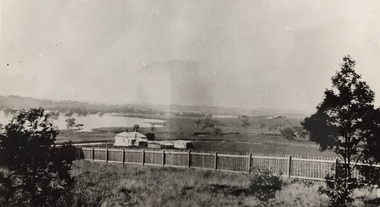
Photograph, Wade's Farm, Kilby Road, Nineteenth Century
""The public trial of reaping machines, under the auspices of the Port Phillip Farmers' Society, advertised to take place on Friday, last, but postponed on account of the weather, came off December 27. The place selected (Mr. Wade's farm, Belford, near Kew) is undulating ground, with a remarkably heavy crop of wheat upon it. This, taken in connection with, the state of the ground, still soft from the recent rains, made the trial an uncommonly severe one. ..."(South Australian Advertiser, 15 January 1859) Some bricks used in Kew buildings came from the brickworks on Wade's Farm at the end of Belford Road near the Yarra River (now part of the Kew Golf Club). (History of RSL by John Torpey)Wade's Farm, Kilby Road, Kew.wade's farm, farming (kew), kilby road, north kew, belford road, kew, kew golf club -
 Ringwood and District Historical Society
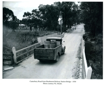
Photographs / Album Pages, Canterbury Road from Heathmont Railway Station Bridge 1954, 1954
Houghton & Byrne Pest Service Truck on Canterbury Road crossing Heathmont Railway Station Bridge 1954. Photo courtesy Vic. RoadsCanterbury Road from Heathmont Railway Station Bridge - 1954. Photo courtesy Vic. Roads -
 Glenelg Shire Council Cultural Collection
Book, Glenelg Shire, 150 Years in the Making, Jul-14
a) Book, Glenelg Shire, 150 Years in the Making. Produced by Glenelg Shire Council, launched July 2014. Card cover, views of early Portland front and back covers, sepia tones, Glenelg Shire logo on front. Black print, black and white and coloured photographs b) envelope for the book white with a Glenelg Shire logo printed on it.glenelg shire, local history, portland, nelson, dartmoor, heywood, casterton -
 Victorian Apiarists Association
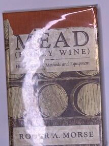
Publication, Making Mead (Honey Wine) (Roger A. Morse), 1980
Approx A5 size hard cover book. Under Cover orange cloth, outer cover is torn on the front at the top so can't read the full title. Cover is cream, brown & white with pictures of wine barrels on the front. On the back is an old mead recipe by Sir Kenelme Digbie - 1669 Inside the front cover is a blurb about the author & finished inside the back cover 125 pages -
 Glen Eira Historical Society
Album - Album page, Glen Huntly Road, Circa 1972
This photograph is part of the Caulfield Historical Album 1972. This album was created in approximately 1972 as part of a project by the Caulfield Historical Society to assist in identifying buildings worthy of preservation. The album is related to a Survey the Caulfield Historical Society developed in collaboration with the National Trust of Australia (Victoria) and Caulfield City Council to identify historic buildings within the City of Caulfield that warranted the protection of a National Trust Classification. Principal photographer thought to be Trevor Hart, member of Caulfield Historical Society. Most photographs were taken between 1966-1972 with a small number of photographs being older and from unknown sources. All photographs are black and white except where stated, with 386 photographs over 198 pages. From: Glen Eira Heritage Management Plan (1996) by Andrew Ward and Associates Moore's Buildings", were built in 1891 and comprising 5 shops. In 1888, Hugh Moore, a gentleman, subdivided his land in Glen Huntly Road, north side between Selwyn Street and St Georges Road into 27 lots, with a right of way separating them from his property "Glenmoore". The subdivision was known as the "Glenmoore Estate". Purchases of land included local builders Corkill, French and Pugh. Moore retained five lots and W.W. Jamieson bought lots 11 to 14. "Moore' s Buildings are locally important for their association with the early Elsternwick land owner, Hugh Moore, whose home, "Glenmoore", at 1 St.Georges Road (qv) survives. They recall Elsternwick's role in the Land Boom and survive as a most prominent row in the Glen Huntly Road shops, enhanced by the survival of the unpainted stuccoed surfaces to nos. 307-311. 287-289 Glen Huntly Road: contributory to HO72, Elsternwick Estate and Environs, City of Glen Eira.Page 63 of Photograph Album with one landscape photograph of retail shops (Moore's Buildings).Hand written: 287-289 Glen Huntly Road [under photo] / 63 [bottom left] trevor hart, shop, grocer, stuccoed, terrace, victorian terrace, protruding parapet, ornate render, hugh moore, 1890's, moore's buildings, glenmoore, glenmoore estate, shopping centres, milk bars, cars, victorian style, glen huntly road, glenhuntly road, elsternwick -
 Glen Eira Historical Society
Album - Album page, Normanby Road, Circa 1972
This photograph is part of the Caulfield Historical Album 1972. This album was created in approximately 1972 as part of a project by the Caulfield Historical Society to assist in identifying buildings worthy of preservation. The album is related to a Survey the Caulfield Historical Society developed in collaboration with the National Trust of Australia (Victoria) and Caulfield City Council to identify historic buildings within the City of Caulfield that warranted the protection of a National Trust Classification. Principal photographer thought to be Trevor Hart, member of Caulfield Historical Society. Most photographs were taken between 1966-1972 with a small number of photographs being older and from unknown sources. All photographs are black and white except where stated, with 386 photographs over 198 pages. From: Glen Eira Heritage Management Plan (1996) - Vol 2 by Andrew Ward and Associates The widening of Dandenong Road during the late 1980's has resulted in the destruction of the houses in the path of the roadworks and the construction of a high fence serving as a visual barrier between that thoroughfare and the remaining houses. Where comparatively large villas once stood on spacious allotments, only "Wisteria" survives at No. 135 Normanby Road. Adopting forms and timber enrichment characteristic of the American Queen Anne style, it has this in common with the largely reconstructed timber villa at no. 11 Normanby Avenue and to a lesser extent, 746 Inkerman Road. Normanby Road retains its comparatively opulent Edwardian character in a mature landscaped setting with spacious gardens and mature planes parallel with the railway reserve which, on account of the low lying ground in its vicinity has a high embankment commencing on the alignment of Malvern Grove and continuing to Caulfield Station. The earliest villas are Edwardian. Page 148 of Photograph Album with one landscape photograph of a house on Normanby Road (not Street).Handwritten: Normanby St [top right] / 148 [bottom right]trevor hart, verandah, porch, bull nosed verandah, tower house, tower, stone fence, normanby road, wisteria, american queen anne style, queen anne style, 1890's, mayfield grove, normanby street, timber houses, caulfield north, house names, edwardian, edwardian style, gardens -
University of Melbourne, Burnley Campus Archives
Slide - Glass slide, 1891-1905
Warrnambool Agricultural and Horticultural Society '54. Warnambool A.H.S. - Ensilage Making.'54. Warnambool A.H.S. - Ensilage Making.school gardens, australia, warrnambool agricultural and horticultural society -
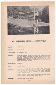
 Marysville & District Historical Society
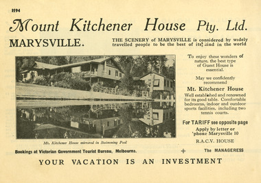
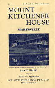
Ephemera (item) - Information booklet advertisement, Broadbent's Official Road Guides Company, MT. KITCHENER HOUSE - MARYSVILLE, Unknown
An advertisement for Mount Kitchener House in Marysville taken from a Broadbent's accommodation guide.An advertisement for Mount Kitchener House in Marysville taken from a Broadbent's accommodation guide.marysville, victoria, australia, mount kitchener house, mt kitchener house, kitchener house, accommodation, broadbent's accommodation guide -
 Marysville & District Historical Society
Ephemera (item) - Information booklet advertisement, Broadbent's Official Road Guides Company, MT. KITCHENER HOUSE - MARYSVILLE, Unknown
A digital copy of an advertisement for Mount Kitchener House in Marysville that was taken from a Broadbent's accommodation guide.A digital copy of an advertisement for Mount Kitchener House in Marysville that was taken from a Broadbent's accommodation guide.marysville, victoria, australia, mount kitchener house, mt kitchener house, kitchener house, accommodation, broadbent's accommodation guide -
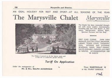 Marysville & District Historical Society
Ephemera (Item) - Information booklet advertisement, Broadbent's Official Road Guides Company, The Marysville Chalet, 1948
An advertisement for The Marysville Chalet guest house in Marysville taken from a Broadbent's accommodation guide.An advertisement for The Marysville Chalet guest house in Marysville taken from a Broadbent's accommodation guide.marysville, victoria, australia, the marysville chalet, guest house, poontawan, steavenson hotel, albert harrison, margaret harrison, elise ackerman, ralph ackerman, john van ranglerooy, joe keithard, kathy keithard, louisa goding, accommodation, broadbent's accommodation guide -
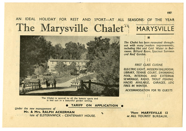 Marysville & District Historical Society
Ephemera (Item) - Information booklet advertisement, Broadbent's Official Road Guides Company, The Marysville Chalet, Unknown
An advertisement for The Marysville Chalet guest house in Marysville taken from a Broadbent's accommodation guide.An advertisement for The Marysville Chalet guest house in Marysville taken from a Broadbent's accommodation guide.marysville, victoria, australia, the marysville chalet, guest house, poontawan, steavenson hotel, albert harrison, margaret harrison, elise ackerman, ralph ackerman, john van ranglerooy, joe keithard, kathy keithard, louisa goding, accommodation, broadbent's accommodation guide -
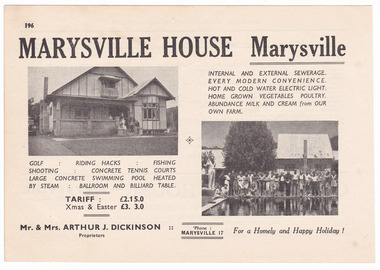 Marysville & District Historical Society
Ephemera (Item) - Accommodation booklet advertisement, Broadbent's Official Road Guides Company, MARYSVILLE HOUSE Marysville, Unknown
An advertisement for Marysville House near Marysville which was taken from a Broadbent's accommodation guide. Marysville House was built in the late 1920s by Arthur Dickinson.An advertisement for Marysville House near Marysville which was taken from a Broadbent's accommodation guide. Marysville House was built in the late 1920s by Arthur Dickinson.marysville, victoria, australia, marysville house, arthur james dickinson, grace dickinson, arnold spooner, eileen marie spooner, eileen marie dickinson, grace sweetland, eric dowdle, elsie may denton, elsie may dickinson, peter dickinson, linda dickinson, 2009 black saturday bushfires, advertisement, accommodation, broadbent's accommodation guide -
 Marysville & District Historical Society
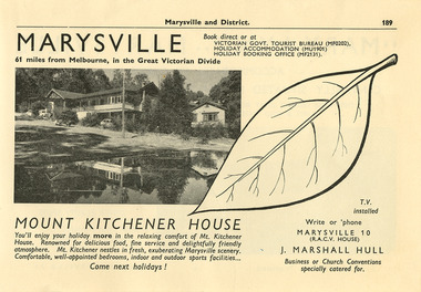
Ephemera (item) - Information booklet advertisement, Broadbent's Official Road Guides Company, MT. KITCHENER HOUSE - MARYSVILLE, Unknown
An advertisement for Mount Kitchener House in Marysville taken from a Broadbent's accommodation guide.An advertisement for Mount Kitchener House in Marysville taken from a Broadbent's accommodation guide.marysville, victoria, australia, mount kitchener house, mt kitchener house, kitchener house, accommodation, broadbent's accommodation guide -
 Marysville & District Historical Society
Ephemera (item) - Information booklet advertisement, Broadbent's Official Road Guides Company, MT. KITCHENER HOUSE - MARYSVILLE, Unknown
An advertisement for Mount Kitchener House in Marysville taken from a Broadbent's accommodation guide.An advertisement for Mount Kitchener House in Marysville taken from a Broadbent's accommodation guide.marysville, victoria, australia, mount kitchener house, mt kitchener house, kitchener house, accommodation, broadbent's accommodation guide -
 Marysville & District Historical Society
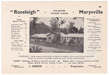
Ephemera (item) - Accommodation booklet advertisement, Broadbent's Official Road Guides Company, "Roseleigh" Marysville, Unknown
An advertisement for Roseleigh guest house in Marysville which was taken from a Broadbent's accommodation guide.An advertisement for Roseleigh guest house in Marysville which was taken from a Broadbent's accommodation guide.marysville, victoria, australia, roseleigh guest house, grieve family, thomas charles grieve, john arthur grieve, rose grieve, ackerman family, mary moyne, elise ackerman, ken mcleod, george peters, rose emily pullum, beltana, rose lillian smith, ivy may grieve, alexander james ficinus, raymond charles smith, advertisement, accommodation, broadbent's accommodation guide -
 Marysville & District Historical Society
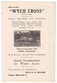
Ephemera (item) - Accommodation booklet advertisement, Broadbent's Official Road Guides Company, "WYCH CROSS", Unknown
An advertisement for Wych Cross guest house in Marysville taken from a Broadbent's accommodation guide.An advertisement for Wych Cross guest house in Marysville taken from a Broadbent's accommodation guide.marysville, victoria, australia, wych cross, felix st hilary jellicoe, katherine st hilary jellicoe, victorian police gazette, lord jellicoe, henry beater christian, broadbent's accommodation guide, advertisement -
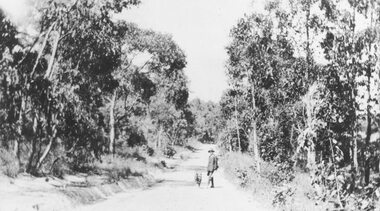 Ringwood and District Historical Society
Photograph, Deep Creek Road in the early days (undated)
Narrow Dirt Road, with you man and dog standing in road. No date.Typed below photograph, "Deep Creek Road in the early days". -
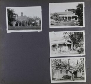 Glen Eira Historical Society
Album - Album page, Seymour Road, Circa 1972
This album was created in approximately 1972 as part of a project by the Caulfield Historical Society to assist in identifying buildings worthy of preservation. The album is related to a Survey the Caulfield Historical Society developed in collaboration with the National Trust of Australia (Victoria) and Caulfield City Council to identify historic buildings within the City of Caulfield that warranted the protection of a National Trust Classification. Principal photographer thought to be Trevor Hart, member of Caulfield Historical Society. Most photographs were taken between 1966-1972 with a small number of photographs being older and from unknown sources. All photographs are black and white except where stated, with 386 photographs over 198 pages. As at 22/08/2021, 61 Seymour Road is included in the HO179 Beemery Park Precinct which C204glen Amendment seeks to add to the Glen Eira Planning Scheme (amongst others). This is not yet finalised.Page 191 of Photograph Album with four photographs of two different properties on Seymour Road. One photo on the left, with the other three all on the right. Handwritten: 61 [under top left photo] / 32 [under top right photo] / 32 [beside bottom right photo] / 191 [bottom left]trevor hart, elsternwick, seymour road, late victorian, italianate style, verandahs, cast iron work, gardens -
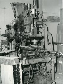 Vision Australia
Photograph - Image, Broom making machine, July 1965?
Broom making machine at the Queensland Institute for the Blind. Image is also located at Queensland State Archives with creation attribute to Lands Dept.2 x black and white photographsqueensland institute for the blind, employment -
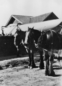 Surrey Hills Historical Society Collection
Photograph, 213 Union Road, Surrey Hills c1930, 1930
The photo shows part of the process of moving a yacht, named 'Sonia' from 213 Union Road, the home of the Fleming family. It was built in the shed garage of the house and moved from it by horse and dray. The home belonged to Harold Arthur Fleming (1891-1971) and his wife, Georgiana Phyllis (nee Griffiths: 1895-1936). Harold built the boat. They had 3 children - Eric Alexander (1918-1920), Sybil Patricia (1921-2012) and another girl. The shed /garage had been the old coach house of the adjoining property, 215 Union Road. the boat was launched at the Brighton Yacht Club. Harold was a draughtsman. The Flemings lived in a number of houses in Surrey Hills: 1. 1919 - 'Radnor' in Croydon Road; the name possibly derives from Radnorshire, Wales where Georgiana was born. 2. 1921 - 169 Union Road 3. 1931 - 213 Union Road. The donor (deceased) was the daughter of the builder and married Keith Andrew Fleming. A black & white photo with 3 draught horses in the foreground. Beyond the path and fence behind them is the roof of 213 Union Road. Between the fence and the house the view is blocked by the hull of a yacht.harold arthur fleming, miss georgiana phyllis griffiths, mrs georgiana phyllis fleming, 213 union road, horses, boating -
Vision Australia
Text, Workplace Innovator Agreement Making Partnerships Programme certificate, 2007
A paper certificate stating that "The Hon Joe Hockey MP, Minister for Employment and Workplace Relations, recognises Vision Australia for outstanding innovation in agreement making and improving workplace arrangements for the benefit of all". Above this writing is a large Australian coat of arms in colour with the words "Workplace Innovator/ Agreement Making Partnerships Programme". At the base of the certificate is "Australian Government, Workplace Authority" and a much smaller coat of arms in blue.1 x col. A4 certificate -
 Orbost & District Historical Society
folder, Orbost Bridges - Snowy River Road Bridges, 1974 1976
This folder was compiled in October 2015 from documents, magazines. papers and photographs donated by David Jellie, engineer in charge 1974 - 1976. In early 1974, as an Engineer with the Country Roads Board, David came to Orbost as the Supervising Engineer for the construction of the new bridges which were part of an 8.4km Orbost bypass road design. This was a major project involving not only a new bridge over the Snowy River (including Lochiel Lagoon), but other bridges over Ashby’s Gulch and Watt’s Gulch. These new bridges were opened in November 1976 with the unveiling of a plaque on the eastern end of the $2.4M Snowy River Bridge. (ref. May Leatch)This item is a useful reference tool on the construction history of the Snowy River Road bridges.A white plastic folder - Orbost Bridges - Snowy River Road Bridges. it contains newspaper articles, booklets, photographs and documents relating to the construction of the Snowy River Road Bridge in 1974 -1976.on front cover - 1974 - 76 ORBOST / SNOWY RIVER ROAD BRIDGES * construction * photos * articles * plans Donated by David Jellie Oct 2015snowy-river-bridges jellie-david -
 St Kilda Historical Society
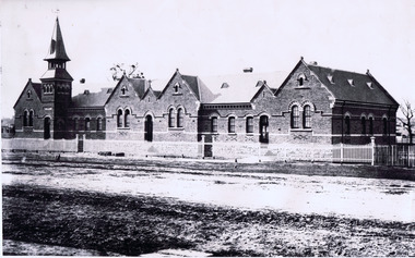
Photograph, St Kilda Primary School, (BrIghton Road) 1882, c. 1882
St Kilda Primary School, (BrIghton Road) 1882, additional notes: built in 1875 On the back: Copy courtesy LaTrobe Library, Melbourne From: Archives Victoria Photographs of State School Buildings. Vol 1. State School, St Kilda (Brighton Road) Hand written: School built 1975. Tower was not moved until some time after 1882. Accompanied by a smaller copy of the same photograph.black and white photograph fair condition unmountedSt Kilda Primary School, (BrIghton Road) 1882, additional notes: built in 1875 On the back: Copy courtesy LaTrobe Library, Melbourne From: Archives Victoria Photographs of State School Buildings. Vol 1. State School, Paterson Bros. Photos. Melbourne. St Kilda (Brighton Road) 1882. School built 1975. Tower was not moved until some time after 1882. D.J Taggart 58 Glenhuntly road, Elwood 3184. St Kilda Historical Collection, 150 Carlisle street, St Kilda. -
 Phillip Island and District Historical Society Inc.
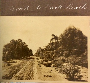
Photograph, Road to the Back Beach, 1925-1926
Sepia photograph of an rough, sandy, unmade road with trees and bushes along the side.Road to the Back Beachphotographs, phillip island early roads -
 Mt Dandenong & District Historical Society Inc.
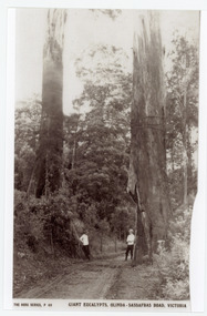
Photograph, Giant Eucalypts, Olinda-Sassafras Road. Victoria
Rose Series post card # P.69 .The Sassafras - Olinda Road showing giant Eucalypts. The two men in the photograph most probably worked for The Rose Series Post card company. They often appear in photographs - probably to give perspective.Copy of Rose Series post card P. 69 showing two men standing alongside giant trees on the Olinda-Sassafras Road.On front: THE ROSE SERIES P. 69 GIANT EUCALYPTS, OLINDA-SASSAFRAS ROAD, VICTORIA.sassafras, olinda, sassafras-olinda road, olinda-sassafras road, rose series, post cards, eucalypts, road -
 Kew Historical Society Inc
Photograph, Stuart Tompkins Studio, Electricity Supply Poles, Warrigal Road, Ashwood, 1965
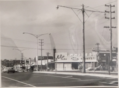
Research provided by Stuart Tompkins Studio, Box Hill, into alternatives for median strip street lighting to be used in Burke Road, Kew. The photographers identified variants in different suburbs appropriate to Kew's needs.The series from which the photograph is drawn provides a snapshot by a commercial photographic studio of each named vicinity in 1965 as well as providing examples of public works infrastructure being commissioned by local government in the 1960s. The photos originally formed part of the Engineering Department's files in the City of Kew before being donated to the kew Historical Society.Electricity Supply Poles, Warrigal Road, Ashwood, 1965. Stuart Tompkins Studio provided this photograph for the Kew City Council. The photograph, taken at the intersection of Warrigal Road and High Street South, Ashwood looks north along High Street Road. The intent of the photograph was to provide the Council with models of electricity supply poles. In the photo, wooden and steel poles can be seen in the median strip. The photograph also includes the shops bordering High Street Road during this period. [There are three copies of this photograph in the Collection.]. Typed inscription on reverse: "Electricity Supply Poles. Photographed for Kew City Council 8/2/65. No.4 Warrigal Road - Ashwood. South of High Street Road looking north. Wooden and steel poles with different brackets in median strip." Studio stamp: "Stuart Tompkins Studio. 547 Station Street, Box Hill. WX1439."electric light poles, public works -- 1960s, civic infrastructure -- 1960s -
 Kew Historical Society Inc
Photograph, Stuart Tompkins Studio, Electricity Supply Poles, Warrigal Road, Ashwood, 1965
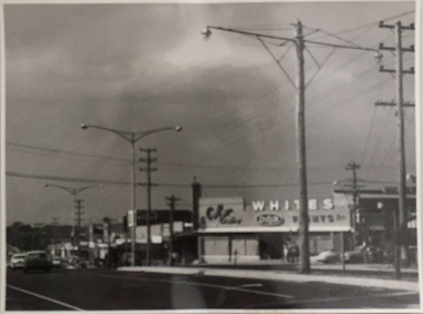
Research provided by Stuart Tompkins Studio, Box Hill, into alternatives for median strip street lighting to be used in Burke Road, Kew. The photographers identified variants in different suburbs appropriate to Kew's needs.The series from which the photograph is drawn provides a snapshot by a commercial photographic studio of each named vicinity in 1965 as well as providing examples of public works infrastructure being commissioned by local government in the 1960s. The photos originally formed part of the Engineering Department's files in the City of Kew before being donated to the kew Historical Society.Electricity Supply Poles, Warrigal Road, Ashwood, 1965. Stuart Tompkins Studio provided this photograph for the Kew City Council. The photograph, taken at the intersection of Warrigal Road and High Street South, Ashwood looks north along High Street Road. The intent of the photograph was to provide the Council with models of electricity supply poles. In the photo, wooden and steel poles can be seen in the median strip. The photograph also includes the shops bordering High Street Road during this period. [There are three copies of this photograph in the Collection.]. Typed inscription on reverse: "Electricity Supply Poles. Photographed for Kew City Council 8/2/65. No.4 Warrigal Road - Ashwood. South of High Street Road looking north. Wooden and steel poles with different brackets in median strip." Studio stamp: "Stuart Tompkins Studio. 547 Station Street, Box Hill. WX1439."electric light poles, civic infrastructure - 1960s, public works -- 1960s -
 Kew Historical Society Inc
Photograph, Stuart Tompkins Studio, Electricity Supply Poles, Warrigal Road, Ashwood, 1965
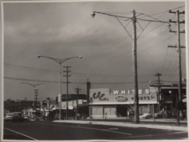
Research provided by Stuart Tompkins Studio, Box Hill, into alternatives for median strip street lighting to be used in Burke Road, Kew. The photographers identified variants in different suburbs appropriate to Kew's needs.The series from which the photograph is drawn provides a snapshot by a commercial photographic studio of each named vicinity in 1965 as well as providing examples of public works infrastructure being commissioned by local government in the 1960s. The photos originally formed part of the Engineering Department's files in the City of Kew before being donated to the kew Historical Society.Electricity Supply Poles, Warrigal Road, Ashwood, 1965. Stuart Tompkins Studio provided this photograph for the Kew City Council. The photograph, taken at the intersection of Warrigal Road and High Street South, Ashwood looks north along High Street Road. The intent of the photograph was to provide the Council with models of electricity supply poles. In the photo, wooden and steel poles can be seen in the median strip. The photograph also includes the shops bordering High Street Road during this period. [There are three copies of this photograph in the Collection.]. Typed inscription on reverse: "Electricity Supply Poles. Photographed for Kew City Council 8/2/65. No.4 Warrigal Road - Ashwood. South of High Street Road looking north. Wooden and steel poles with different brackets in median strip." Studio stamp: "Stuart Tompkins Studio. 547 Station Street, Box Hill. WX1439."electric light poles, public infrastructure -- 1960s, civic works -- 1960s -
 City of Kingston
Photograph - Digital image, Black and white, Roads - Junction of Nepean Highway and South Road, c. 1950
Junction of Nepean Highway and South Road, Moorabbin - Moorabbin Hotel on right. Shops in centre demolished for road widening in 1980'sBlack and white image of Nepean Highway and South Road junction point of view from Kingston Town HallPrinted in black text a round white sticker: 234 Handwritten in red ink 80% Yellow post it note written in blue ink: CHAP 7 234 / - Nepean Hwy + South Roadnepean highway, south road, moorabbin, moorabbin hotel -
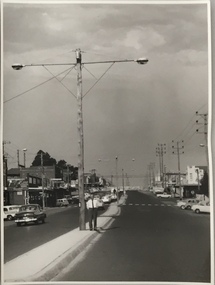 Kew Historical Society Inc
Photograph, Stuart Tompkins Studio, Electricity Supply Poles, North Road, Ormond, 1965
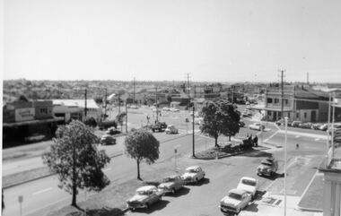
Research provided by Stuart Tompkins Studio, Box Hill, into alternatives for median strip street lighting to be used in Burke Road, Kew. The photographers identified variants in different suburbs appropriate to Kew's needs.The series from which the photograph is drawn provides a snapshot by a commercial photographic studio of each named vicinity in 1965 as well as providing examples of public works infrastructure being commissioned by local government in the 1960s. The photos originally formed part of the Engineering Department's files in the City of Kew before being donated to the kew Historical Society.Electricity Supply Poles, North Road, Ormond, 1965. Electricity supply poles photographed for the Kew City Council by Stuart Tompkins Studio. The photograph of North Road, Ormond west of Jasper Road, looking east depicts wooden poles carrying two lamps in a median strip and with two on each side alternately. It was noted that the supply wires were from one side only. The poles were described as 3′ above ground and 11.25″ in diameter. The plan was to use this approach for Burke Road, Kew. [There are three copies of this photograph in the Collection.] Typed inscription on reverse: "Electricity Supply Poles. Photographed for Kew City Council 8/2/65. No.1 North Road - Ormond, west of Jasper Road, looking east. Wooden poles carrying two lamps in median strip and two on each side alternately just as is proposed for Burke Road, Kew. Supply wires from one side only. Poles 3' above ground 11 1/4" dia." Studio stamp: "Stuart Tompkins Studio. 547 Station Street, Box Hill. WX1439."stuart tompkins studio, street lighting, south road (moorabin) 1965, public infrastructure -- city of kew, city of kew -- engineer's department