Showing 174550 items
matching rock-street
-
 Phillip Island and District Historical Society Inc.
Photograph - Post Card, 1960's
Donated by S. Serpell of Serpell & Reid families, SandringhamSepia Photo of Pyramid Rock, Phillip IslandPyramid Rock, Phillip Islandphillip island -
 Tatura Irrigation & Wartime Camps Museum
Photograph, Hogan Street Tatura pre 1914, pre 1914 original
Small photograph used on greeting card. Showing Hogan Street, Tatura, looking east. Shops on left, trees, telegraph poles, horses and buggies.Original sepia photograph of Hogan Street Tatura looking east pre 1914Hogan Street Tatura. Greetingshogan street tatura -
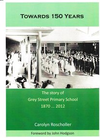 Grey Street Primary School, Traralgon
Book, Towards 150 Years. The story of Grey Street Primary School 1870 ... 2012, 2012
Commissioned to be written in 2012 to coincide with the centenary of the opening of the school at the new site in Grey Street, Traralgon. Includes historical information on the first school in Argyle Street in 1870, and its relocation to Campbell Street in 1872. Chapters are set out in decades. Many historical photos of various classes most of which include pupil and staff names.This book tells the story of the commencement of state education in Traralgon in 1870, and follows the development of Traralgon State School into the present Grey Street Primary School.A4. Cover photo depicting children in quadrangle at official opening of Grey Street Primary School in 1912. Cover printed in full process both sides. Text printed in Black throughout, except 16pp colour, perfect bound and packed. Cover: Towards 150 Years/ The story of/ Grey Street Primary School/ 1870 ... 2012/ Carolyn Roscholler/ Foreword by John Hodgson Spine: Towards 150 Years - Carolyn Roscholler Complete typesetting by Gippsland Printers.grey street., traralgon state school, campbell street, traralgon -
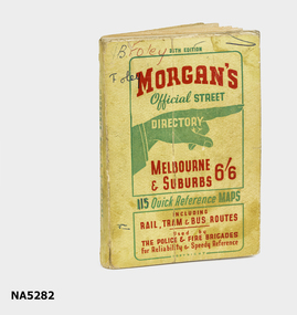 Whitehorse Historical Society Inc.
Map - Street directory, Morgans Official Street Directory
Morgan's street directories lack dates. Donor's parents, who lived in Blackburn, used this street directory .Small soft covered book of official street directory of Melbourne and suburbs.Morgans Official Street Directory Melbourne and Suburbs 6/6maps -
 Eltham District Historical Society Inc
Photograph, Mary Owen, granddaughter of Walter Withers unveils the commemorative plaque on Walter Withers Rock at the corner of Bible and Arthur Streets, Eltham, 13 Oct 1990, 13/10/1990
Roll of 35mm colour negative film, 1 stripFuji 100 Nwalter withers rock, walter withers reserve, bible street, arthur street, eltham, plaques -
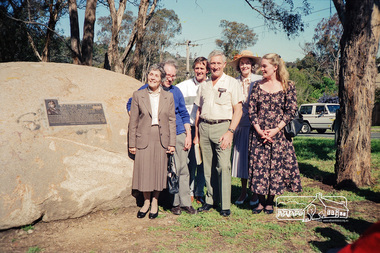 Eltham District Historical Society Inc
Photograph, From left, Mary Owen and John Withers, grandchildren of Walter Withers and other family members at the unveiling of the commemorative plaque on Walter Withers Rock at the corner of Bible and Arthur Streets, Eltham, 13 Oct 1990, 13/10/1990
Roll of 35mm colour negative film, 1 stripFuji 100 Nwalter withers rock, walter withers reserve, bible street, arthur street, eltham, plaques -
 Eltham District Historical Society Inc
Photograph, Unveiling of the commemorative plaque on Walter Withers Rock at the corner of Bible and Arthur Streets, Eltham, 13 Oct 1990, 13/10/1990
Roll of 35mm colour negative film, 1 stripFuji 100 Nwalter withers rock, walter withers reserve, bible street, arthur street, eltham, plaques -
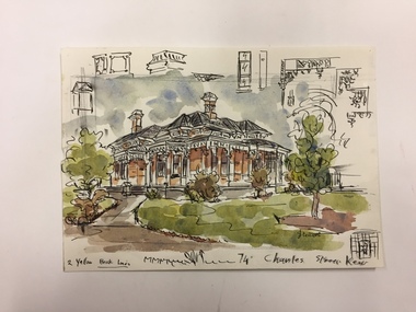 Kew Historical Society Inc
Work on paper, Joy Stewart, 74 Charles Street, Kew, c.1978
Sydney Joy (joy) Stewart (1925-2018) was a founding member of the Kew Historical Society, and during the 1970s its secretary. During her residence in Kew, she completed numerous property illustrations on commission. These ranged from preliminary sketches, including architectural details to finished pen & ink and wash illustrations on paper. On moving to Queensland, Joy Stewart donated the remaining property illustrations in her possession to the Kew Historical Society. In 1987-88 she fulfilled a commission by the Society of designs for a series of embroideries completed by residents during the Australian Bicentennial commemorations.Sydney Joy (Joy) Stewart was born in Melbourne 1925. She studied at Swinburne Technical College Art School from 1941-1945, then the National Gallery Art School 1946-1948. Her career included employment positions as a display artist, designer/painter, gallery assistant, and art teacher. Joy relocated to Cairns in 1981. Solo exhibitions in Melbourne and Cairns, including 'Done By Me' at Cairns Regional Gallery in 1999. Group exhibitions at Cairns Regional Gallery, 'The Fish John West Regrets, 1993' and 'Facets of Life' 1994. Joy Stewart died in Cairns in 2018.Watercolour, pen & Ink on paper by the artist and local historian Joy Stewart of a Victorian villa at 74 Charles Street, Kew.Inscription: "74 Charles Street, Kew." Signed lower right: "JStewart".joy stewart, charles street (kew) -
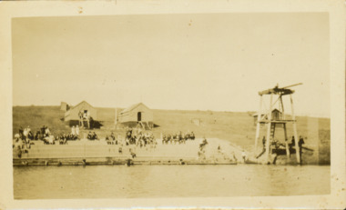 Kew Historical Society Inc
Photograph - Deep Rock Swimming Pool and Clubrooms on the Yarra, c.1925
The former Deep Rock Swimming Pool was about 500 yards [457 metres] above Dight’s Falls. It was there that the Deep Rock Swimming Club was established in 1906. This initial club was expanded in 1916 to incorporate a life-saving club. In 1918, John Wren, the president of the club offered the club £1000, and undertook to sponsor a patriotic carnival in March 1918, at which swimming champions would take part. The ‘pool’ was to achieve fame as the venue for a world record-breaking ‘swallow dive’ of 205 feet 9 inches [63 metres] by ‘Prince Wickyama’, [aka Alec Wickham], a Solomon Islander. The dive from a special platform on the west side of the Yarra was reputedly viewed by between 50,000-100,000 spectators, with funds going to the State War Council. The Herald, 25 March 1918, claimed that the wide area occupied by spectators made more precise estimates impossible. In the 1980s, the construction of the Eastern Freeway, and the consequent re-routing of the Yarra River led to the site of the Deep Rock Pool being obliterated. A small cairn and plaque on the Fairfield side of the river now marks its former site.Very rare early photograph off the Deep Rock swimming pool. The pool and its built structures are historically and socially important to the people of Collingwood, Fairfield and Kew. Small, faded, Gelatin Silver print positive photograph of the Deep Rock Swimming Pool situated on the Yarra at Collingwood and Fairfield. The famous diving tower is at the right of the photo. The built structures were constructed for the Deep Rock Swimming and Life Saving Club. People are sitting on the terraces above the river. "Bathing Club. Deep Rock on the Yarra. Studley Park Melbourne. Please credit E.J. Thomasson Collection"deep rock swimming pool, deep rock swimming club, deep rock lifesaving club, swimming -- river yarra, river yarra -
 Surrey Hills Historical Society Collection
Photograph, Churchill Street, Mont Albert and Mont Albert Station, looking towards Hamilton Street, 1919, 1919
The railway extended through to Mont Albert in 1882, but it wasn't until 1890 that a station was built with funds raised by a syndicate of local landowners.The buildings on the south side of the railway were built in 1910-1911 in the Arts and Crafts style by architect, K W Hardy. The land occupied by the Hamilton Street shops was subdivided in the 1880s and the first purpose-built shop was 'Pope and Moran, Grocers'. This shop later became Tom Morris' Grocery. By 1930 shops stretched along both sides of Hamilton Street and part way along Churchill Street. The donor, the late Norman Carter held a significant collection of photos taken around Mont Albert and Surrey Hills, in particular subjects related to the Church of England.Black and white photo taken from the centre of the road in Churchill Street, Mont Albert. Mont Albert station is on the RHS fenced off by a post and rail fence. Shops can be seen at the intersection of Hamilton and Churchill Streets. There do not appear to be any shops in Churchill Street. There are newly planted street trees within paling guards on the LHS. There does not appear to be any curb and channelling at the side of the road.Rear in blue biro in Jocelyn Hall's handwriting "Mont Albert Station 1919".mont albert station, railways, hamilton street, churchill street, shops, arts and crafts style, norman carter -
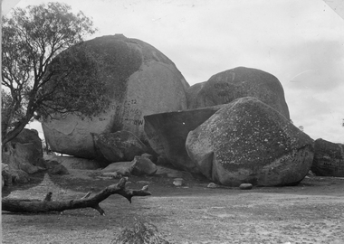 Stawell Historical Society Inc
Photograph, Sister Rocks looking West
Sister Rocks Looking WestPhotograph of Sister Rock's looking west Sister Rock's - at Stawell pre Graffiti stawell tourism -
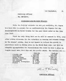 Melbourne Tram Museum
Document - Report, Melbourne & Metropolitan Tramways Board (MMTB), "St Kilda Brighton Beach and Sandringham - Black Rock Tramway", 8 or 9/1950
Set of two memos - carbon copies on quarto paper - from the Publicity Officer to the Chairman regarding the financial returns for both the "St Kilda Brighton Beach and Sandringham - Black Rock Tramway". .1 - dated 24/8/1950 - discussing the financial returns and passengers on both lines. Based on information from the Annual Reports. .2 - dated 1/9/1950 - based on confidential information, insufficient profit to justify and patronage not growing with population growth.Signed or initialled by Lewis Russell.trams, tramways, vr, st kilda brighton, sandringham, black rock, financial statements, costs -
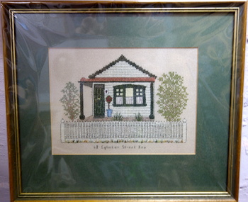 Kew Historical Society Inc
Textile, 68 Eglinton Street, Kew, 1980-2000
Framed embroidery, 68 Eglinton Street Kew. Undated. Home of the Bogle family during the First World War. Thomas Bogle Reg No. 479 Church of England, Single, Labourer, Father William Bogle (same address), enlisted 1915 29th Battalion B CompanyNoneSmall framed tapestry of 68 Eglinton Street, a single-fronted weatherboard cottage in Kew.68 EGLINTON STREEThouses - eglinton street - kew (vic), tapestries -
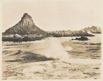
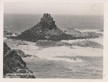 Phillip Island and District Historical Society Inc.
Photograph, 1940's
One of a collection of 15 photographs/postcards donated by Lois MullinsBlack & White photograph of Pyramid Rock, Phillip Island."Pyramid Rock, Phillip Island"pyramid rocks phillip island, phillip island coastline, rock formation phillip island, lois mullins -
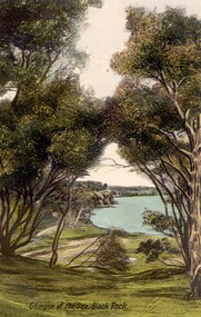 City of Kingston
Postcard - Postcard, Colour, E. Soffa, Glimpse of the sea, Black Rock, c. 1920
Postcards began to be produced in Victoria from 1876. Between 1900 and 1920, picture postcards in Australia became an incredibly popular phenomenon. People could cheaply and easily send messages, without the formality of a letter, and they provided a cheap form of souvenir. Eventually, every event of significance was commemorated in some way with a postcard, and this led to the development of a ‘picture on one side and a message/stamp on the other’ postcard we are familiar with today. They were also a popular form of advertising. This postcard appears to be one in a set of postcards promoting the Black Rock area.Colour postcard feturing a hand tinted photographic image taken from a height, looking down to the sea through bushland.holiday, postcard, black rock, bush land, seaside -
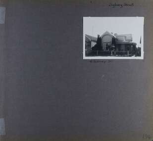 Glen Eira Historical Society
Album - Album page, Sydney Street, Circa 1972
This album was created in approximately 1972 as part of a project by the Caulfield Historical Society to assist in identifying buildings worthy of preservation. The album is related to a Survey the Caulfield Historical Society developed in collaboration with the National Trust of Australia (Victoria) and Caulfield City Council to identify historic buildings within the City of Caulfield that warranted the protection of a National Trust Classification. Principal photographer thought to be Trevor Hart, member of Caulfield Historical Society. Most photographs were taken between 1966-1972 with a small number of photographs being older and from unknown sources. All photographs are black and white except where stated, with 386 photographs over 198 pages. This house has been replaced according to Google image capture Feb 2019.Page 194 of Photograph Album with one photograph of an Edwardian house on Sydney Street, Murrumbeena.Handwritten: Sydney Street [top right] / 16 SYDNEY ST [under photo] / 194 [bottom right]trevor hart, chimneys, porch, garden, verandah, single storey, bull nose verandah, incised weatherboards, edwardian, fretwork, 1900's, return verandah, murrumbeena, sydney street, gardens -
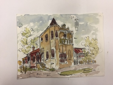 Kew Historical Society Inc
Work on paper, Joy Stewart, Peel Street, Kew, 1978
Sydney Joy (joy) Stewart (1925-2018) was a founding member of the Kew Historical Society, and during the 1970s its secretary. During her residence in Kew, she completed numerous property illustrations on commission. These ranged from preliminary sketches, including architectural details to finished pen & ink and wash illustrations on paper. On moving to Queensland, Joy Stewart donated the remaining property illustrations in her possession to the Kew Historical Society. In 1987-88, she fulfilled a commission by the Society of designs for a series of embroideries completed by residents during the Australian Bicentennial commemorations.Sydney Joy (Joy) Stewart was born in Melbourne 1925. She studied at Swinburne Technical College Art School from 1941-1945, then the National Gallery Art School 1946-1948. Her career included employment positions as a display artist, designer/painter, gallery assistant, and art teacher. Joy relocated to Cairns in 1981. Solo exhibitions in Melbourne and Cairns, including 'Done By Me' at Cairns Regional Gallery in 1999. Group exhibitions at Cairns Regional Gallery, 'The Fish John West Regrets, 1993' and 'Facets of Life' 1994. Joy Stewart died in Cairns in 2018.Watercolour, pen & Ink on paper by the artist and local historian Joy Stewart of a distinctive two-storey Victorian-era house in Peel Street, Kew. Inscription: "Peel Street, Kew." Signed lower right: "JStewart 1978"joy stewart, peel street (kew) -
Tatura Irrigation & Wartime Camps Museum
Photograph, D. Walker photographer, Hogan Street Tatura 1987, 1987
Photograph of Hogan Street, Tatura, looking west. 1987. Clock Tower, monument to Dr. J. Park, in foreground. Railway tracks and crossing lights also in pictureBlack and white photograph of Hogan Street, Tatura looking west. Part of supermarket and Criterion Hotel at left. Street lights, traffic signs, cars.on back: Hogan Street looking west. Clock tower 1987hogan street tatura -
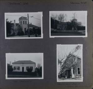 Glen Eira Historical Society
Album - Album page, Ercildoune (576), Inkerman Street, Circa 1972
This photograph is part of the Caulfield Historical Album 1972. This album was created in approximately 1972 as part of a project by the Caulfield Historical Society to assist in identifying buildings worthy of preservation. The album is related to a Survey the Caulfield Historical Society developed in collaboration with the National Trust of Australia (Victoria) and Caulfield City Council to identify historic buildings within the City of Caulfield that warranted the protection of a National Trust Classification. Principal photographer thought to be Trevor Hart, member of Caulfield Historical Society. Most photographs were taken between 1966-1972 with a small number of photographs being older and from unknown sources. All photographs are black and white except where stated, with 386 photographs over 198 pages. Vol 1 Caulfield's Building Heritage by Dr Geulah Solomon states that Ercildoune was the home of Sir Samuel Wilson and later, Arthur Knox. Knox is likely the person who subdivided the land, creating Ercildoune Street.Page 100 of Photograph Album with two photographs (landscape) of Ercildoune and two photographs (one landscape and one portrait) of two other houses on Inkerman Street.Handwritten: "Ercildoune" (576) [top left] / Inkerman Street [top right] / 138 INKERMAN ST [under bottom left photo] / LABASSA GROVE CORNER OF INKERMAN OPPOSITE ERCILDOUNE [under bottom right photo] / 100 [bottom right]trevor hart, east st kilda, ercildoune, mansions, towers, gardens, bloomsbury, inkerman road, labassa grove, attic houses, porches, inkerman street, caulfield north, st kilda east, sir samuel wilson, arthur knox, ercildoune street, house names -
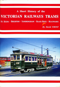 Ballarat Tramway Museum
Book, David Frost, "A short history of the Victorian Railways Trams - St Kilda - Brighton - Sandringham - Black Rock - Beaumaris", May. 2006
Book - 20 pages + card covers, centre stapled titled "A short history of the Victorian Railways Trams - St Kilda - Brighton - Sandringham - Black Rock - Beaumaris". Covers have colour photographs on the outside. Page 11 has a map of the two tramways with the tram lines and features shown in red. Written by David Frost, published May 2006 by Tramway Publications. Edited by Dean Filgate. Provides details of the background of the tramways, Elwood depot fire, Sandringham depot, closure and an Epilogue Has details of the Author.trams, tramways, vr trams, elwood, st kilda brighton, sandringham, beaumaris -
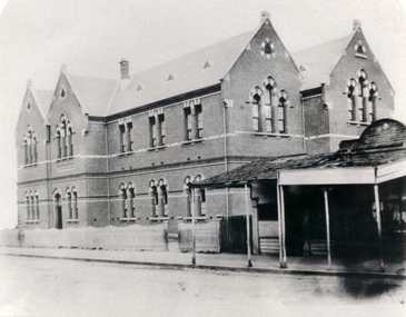 Federation University Historical Collection
Photograph - Black and White, Humffray Street Primary School (no. 34), Ballarat East, 1876, 1876
The Humffray Street Primary School of opened on 10 January 1976.Double storey brick school in Humffray Street Ballarat East. It shows the Humffray Street frontage. humffray street primary school, education -
Coal Creek Community Park & Museum
Cardboard box, Semco Art Needlework Pty Ltd
White rectangular box with blue and gold advertisement, 'Silkette Machine Twist' with map of Australia.Silkette Machine Twist, Silk Substitute, Silkette machine Twist, Semco A.T.C. No.40, 80 yards. Semco Art Needlework Pty. Ltd. "Semco Park" Black Rock, Victoria. Trade Mark. -
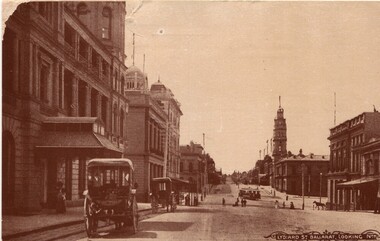 Ballarat Heritage Services
Photograph - Image, Lydiard Street Ballarat Looking North, C1890
Lydiard Street is a street in central Ballarat known for its Victorian architecture. The building with clock tower is the former Ballarat Post Office, the tower stage of the building dating from 1885. It sits on the corner of Sturt Street. Black and white photograph of Lydiard Street Ballarat.lydiard street ballarat, ballarat post office, tram, streetscape, architecture, vintage cars -
 Melbourne Tram Museum
Book, David Frost, "A short history of the Victorian Railways Trams - St Kilda - Brighton - Sandringham - Black Rock - Beaumaris", May. 2006
Book - 20 pages + card covers, centre stapled titled "A short history of the Victorian Railways Trams - St Kilda - Brighton - Sandringham - Black Rock - Beaumaris". Covers have colour photographs on the outside. Page 11 has a map of the two tramways with the tram lines and features shown in red. Written by David Frost, published May 2006 by Tramway Publications. Edited by Dean Filgate. Provides details of the background of the tramways, Elwood depot fire, Sandringham depot, closure and an Epilogue Has details of the Author. Copy 2 added 31-10-2020trams, tramways, vr trams, elwood, st kilda brighton, sandringham, beaumaris -
 Kew Historical Society Inc
Photograph, J F C Farquhar, Wellington Street From High Street, 1891
At the beginning of the 1890s, the Kew businessman and Town Councillor, Henry Kellett, commissioned J.F.C. Farquhar to photograph scenes of Kew. These scenes included panoramas as well as pastoral scenes. The resulting set of twelve photographs was assembled in an album, Kew Where We Live, from which customers could select images for purchase.The preamble to the album describes that the photographs used the ‘argentic bromide’ process, now more commonly known as the gelatine silver process. This form of dry plate photography allowed for the negatives to be kept for weeks before processing, hence its value in landscape photography. The resulting images were considered to be finely grained and everlasting. Evidence of the success of Henry Kellett’s venture can be seen today, in that some of the photographs are held in national collections.It is believed that the Kew Historical Society’s copy of the Kellett album is unique and that the photographs in the book were the first copies taken from the original plates. It is the first and most important series of images produced about Kew. The individual images have proved essential in identifying buildings and places of heritage value in the district.Very few of the natural or built features in this panoramic photograph of Wellington Street remain. The open land between High Street South and Denmark Street, then known as O’Shannessy’s Paddock, was to become a residential subdivision at the beginning of the 20th Century. On the far side of Denmark Street, bordered by a picket fence, is the Kew Railway Station (demolished 1957). Further east, the large building with the flagpole is the Kew Recreation Hall (demolished 1960), which was the centre of civic life for almost a century. The building was used for dances, civic functions and exhibitions. A bowling green, tennis courts, and a cricket ground surrounded the Hall. The dominant building in the photograph is Xavier College, founded in 1872 by the Society of Jesus. The first classes for pupils were held in 1878. It is presumed that Farquhar used its roof for two of his bird’s eye views.Wellington Street from High Streetkew illustrated, kew where we live, photographic books, henry kellett -
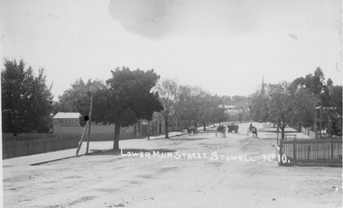 Stawell Historical Society Inc
Photograph, Lower Main Street Stawell looking East c1905. Merle Photographic Studio at Left
Lower Main Street looking East from Railway gates. Shows four horse drawn vehicles. The photo was taken from the railway gates towards the main shopping area. The Presbyterian spire can be seen in the back ground. c1905.Sepia Postcard of a street scene the roadway is central in picture featuring 4 horse drawn vehicles. Street is tree lined with picket fence on right side of photograph. 0007a taken opposite the Diamond house looking down Seaby St. toward the railway crossing.Lower Main Street Stawell No 10. is inscribed on the front and The "Merle Studio" Main Street, Stawell on the back.stawell shops business streetscape building transport -
 Phillip Island and District Historical Society Inc.
Photograph - Post Card, 20th Century
One of a collection of 7 photographs donated by Steve Stefan, Archivist, St Frances Church, MelbourneBlack & White postcard of Pyramid Rock, Phillip Island"85, --- Pyramid Rock. ------ Phillip Island. ----"pyramid rock phillip island, phillip island coastline, rock formations, steve stefan -
Phillip Island and District Historical Society Inc.
Photograph
Part of collection of Photographs donated to the museum by the family of the late Mr. Jack Jenner (1977)Sepia Postcard - View Pyramid Rock, Phillip IslandLabelled "Pyramid Rock, Phillip Island".local history, photography, photographs, slides, film, view phillip island, sepia photograph, jack jenner, pyramid rock, phillip island -
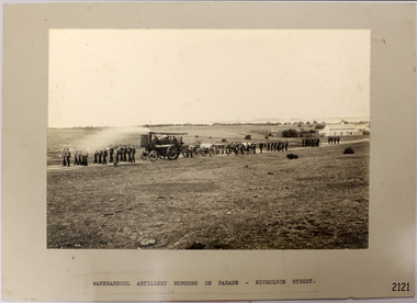 Flagstaff Hill Maritime Museum and Village
Photograph - Military group, Warrnambool Artillery Members on Parade - Nicholson Street [Warrnambool], Early 1900s
Photograph is a point in time with local Militia parading in an area now filled with houses. It show the means by which the cannon carriages were moved between locations, the uniforms of the soldiers and the development of the Warrnambool location.Photograph, landscape, sepia, mounted on card. Image of the Warrnambool Artillery Members on parade in Nicholson Street, Warrnambool. Figures are marching in groups with a steam driven gun carriage pulling several other gun carriages. A house is in the foreground and Lady Bay in the background. A typed label is attached to the bottom of the card."WARRNAMBOOL ARTILLERY MEMBERS ON PARADE - NICHOLSON STREET'flagstaff hill, flagstaff hill maritime museum and village, warrnambool, maritime museum, maritime village, great ocean road, shipwreck coast, warrnambool location, militia, steam driven gun carriage, nicholson street warrnambool -
Tatura Irrigation & Wartime Camps Museum
Photograph, D. Walker photographer, Hogan Street Tatura 1986, 1986
Photograph of Hogan Street, Tatura, looking east on a busy day. Lots of cars about. Shops and businesses include banks, bakery, newsagent, video shop and hotel.Black and white photograph of Hogan Street, Tatura, looking east. 1986.on back: Hogan Street scape looking east. Tatura 1986hogan street tatura