Showing 251 items matching "roundabouts"
-
 Eltham District Historical Society Inc
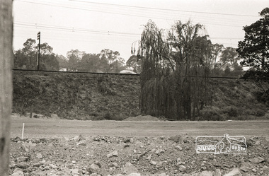
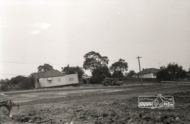
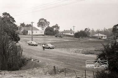
Photograph, Sherbourne Road, Para Road and Simms Road at Briar Hill, 3 November 1967, 3 Nov 1967
Viewed from western side of Para Road near Graham Body Works. Simms Road is running to the right in front of the old house. The house belongs to Mrs Cameron whose daughter married a DAVEY after which Davey Street is named. Excavation work is being undertaken for the realignment of the Para Road and Sherbourne Road intersection where the current roundabout is located, approximately where the two cars are parked. Mrs Cameron's house and the other are where Montmorency Secondary College is situated. The school opened in 1969.Roll of 35mm black and white negative film, 6 strips Ilford HP3briar hill, cameron, davey, davey road, graham body works, greensborough, montmorency secondary college, sherbourne road, simms road -
 Eltham District Historical Society Inc
Photograph, Sherbourne Road, Para Road and Simms Road at Briar Hill, 3 November 1967, 3 Nov 1967
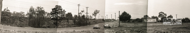
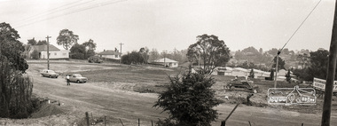
Viewed from western side of Para Road near Graham Body Works. Simms Road is running to the right in front of the old house. The house belongs to Mrs Cameron whose daughter married a DAVEY after which Davey Street is named. Excavation work is being undertaken for the realignment of the Para Road and Sherbourne Road intersection where the current roundabout is located, approximately where the two cars are parked. Mrs Cameron's house and the other are where Montmorency Secondary College is situated. The school opened in 1969.Photostitch from multiple images on roll of film. Roll of 35mm black and white negative film, 6 strips Ilford HP3briar hill, cameron, davey, davey road, graham body works, greensborough, montmorency secondary college, sherbourne road, simms road -
 Eltham District Historical Society Inc
Photograph, Sherbourne Road, Para Road and Simms Road at Briar Hill, 3 November 1967, 3 Nov 1967
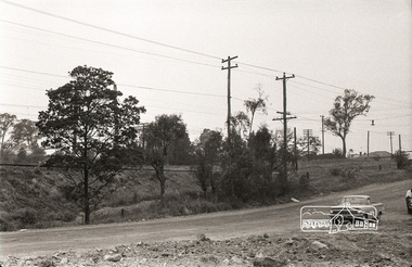
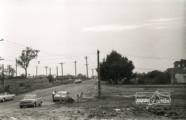
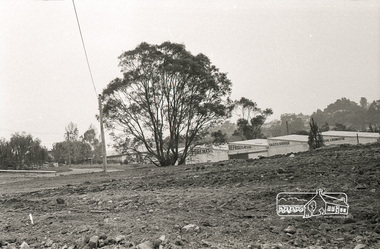
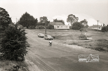
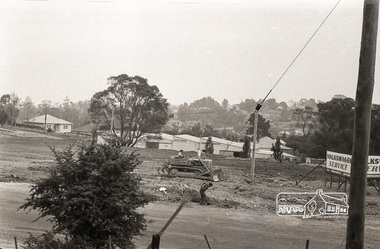
Viewed from eastern side of Para Road opposite Graham Body Works.. Simms Road is running to the right in front of the old house. The house belongs to Mrs Cameron whose daughter married a DAVEY after which Davey Street is named. Excavation work is being undertaken for the realignment of the Para Road and Sherbourne Road intersection where the current roundabout is located, approximately where the two cars are parked. Mrs Cameron's house and the other are where Montmorency Secondary College is situated. The school opened in 1969.Roll of 35mm black and white negative film, 6 strips Ilford HP3briar hill, cameron, davey, davey road, graham body works, greensborough, montmorency secondary college, sherbourne road, simms road -
 Eltham District Historical Society Inc
Photograph, Sherbourne Road, Para Road and Simms Road at Briar Hill, 3 November 1967, 3 Nov 1967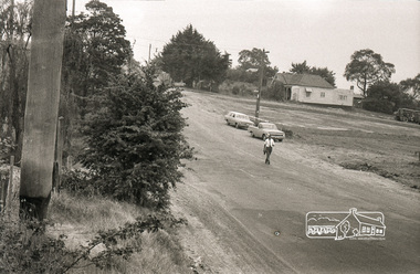
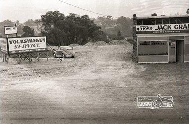
Viewed from eastern side of Para Road opposite Graham Body Works.. Simms Road is running to the right in front of the old house. The house belongs to Mrs Cameron whose daughter married a DAVEY after which Davey Street is named. Excavation work is being undertaken for the realignment of the Para Road and Sherbourne Road intersection where the current roundabout is located, approximately where the two cars are parked. Mrs Cameron's house and the other are where Montmorency Secondary College is situated. The school opened in 1969.Roll of 35mm black and white negative film, 6 strips Ilford HP3briar hill, cameron, davey, davey road, graham body works, greensborough, montmorency secondary college, sherbourne road, simms road, vw service -
 Eltham District Historical Society Inc
Photograph, Sherbourne Road, Para Road and Simms Road at Briar Hill, 3 November 1967, 3 Nov 1967
Viewed from eastern side of Para Road opposite Graham Body Works.. Simms Road is running to the right in front of the old house. The house belongs to Mrs Cameron whose daughter married a DAVEY after which Davey Street is named. Excavation work is being undertaken for the realignment of the Para Road and Sherbourne Road intersection where the current roundabout is located, approximately where the two cars are parked. Mrs Cameron's house and the other are where Montmorency Secondary College is situated. The school opened in 1969.Photostitch from multiple images on roll of film. Roll of 35mm black and white negative film, 6 strips Ilford HP3briar hill, cameron, davey, davey road, graham body works, greensborough, montmorency secondary college, sherbourne road, simms road, vw service -
 Eltham District Historical Society Inc
Photograph, Sherbourne Road, Para Road and Simms Road at Briar Hill, 3 November 1967, 3 Nov 1967
Viewed from eastern side of Para Road opposite Graham Body Works.. Simms Road is running to the right in front of the old house. The house belongs to Mrs Cameron whose daughter married a DAVEY after which Davey Street is named. Excavation work is being undertaken for the realignment of the Para Road and Sherbourne Road intersection where the current roundabout is located, approximately where the two cars are parked. Mrs Cameron's house and the other are where Montmorency Secondary College is situated. The school opened in 1969.Roll of 35mm black and white negative film, 6 strips Ilford HP3briar hill, cameron, davey, davey road, graham body works, greensborough, montmorency secondary college, sherbourne road, simms road, vw beetle, vw service -
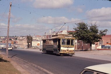 Ballarat Tramway Museum
Slide - 35mm slide/s, Chas Bevan, 19/12/1970 12:00:00 AM
Yields information about the Bakery Hill / Victoria St hill area.Colour slide - 35mm - of Ballarat single trucker 31, about to descend the Bakery Hill in Victoria St, inbound. Tram has the destination of Gardens via Sturt St West. Has the Stones Corner building in the background, Mack Hotel and an advertisement for Beaurepaires tyres. Tram 31 has an a Twin Lakes advertisement and Bliss Bombs (To read pack: Tilt Tram) roof advertisement. Photo taken by Chas Bevan on Saturday 19-12-1970. Note the change since the roundabout for Humffray St was built."Ballarat trams ? Highway. East 19-12-70 - Myers Xmas"tramways, trams, victoria st, bakery hill, stones corner, humffray st, tram 14, tram 17 -
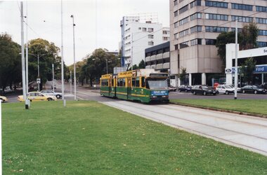 Melbourne Tram Museum
Photograph - Set of 7 Colour Print/s, Colin Rough, 30/01/2002 12:00:00 AM
Set of 7 colour prints taken on 30/1/2002 by Colin Rough at the intersection of Flemington Rd, Royal Parade, Peel St and Elizabeth St at the Haymarket Roundabout. Most trams in the PTC livery. Prior to the installation of traffic lights this roundabout. Printed on Agfa paper. .1 - B class 2087, Royal Parade, Route 19 - With Energiser batteries and Give Joy adverts .2 - B class 2097, as above with City Ford in the background. Has St George bank adverts. .3 - Z3 127 turning from Peel St into Flemington Road with the Turf Club Hotel and the Optus World in the background. .4 - B 2033, in bound to Elizabeth St, route 59, in Flemington Road. Has an advert for used car trading and the Suzuki store in the background. .5 - Z3 176 turning from Peel into Flemington Road, route 55, West Coburg. Has the Bob Jane store in the background and an advert for Tattslotto. .6 - Z3 193 as above, with and advert for MLC. Has an advert for City Subaru in the background. .7 - B 2051, Airport West Route 59 in M>Tram livery.On rear in ink various notes about the location and date - 30/3/2002.trams, tramways, haymarket, flemington rd, peel st, royal parade, elizabeth st, b class, m>tram, ptc, z3 class, airport west, west coburg, route 19, route 55, route 59, tram 2087, tram 2097, tram 127, tram 2033, tram 176, tram 193, tram 2051 -
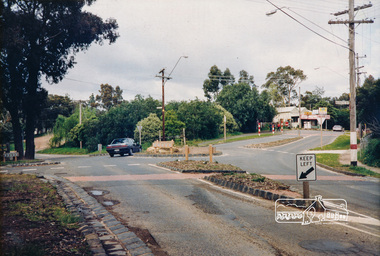 Eltham District Historical Society Inc
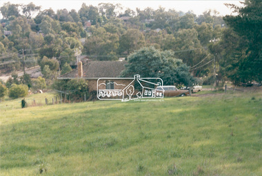
Photograph, Panton Hill Store near the intersection of Merritts Road and Kangaroo Ground-St Andrews Road, Panton Hill, c. Oct 1987, 1987
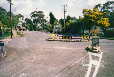
... Roundabouts ...Date based on other similar display panels visible in images of the Shire of Eltham display at the Eltham Community Festival, 7 November 1987. Colour photographinfrastructure, display panel, eltham festival, shire of eltham, general store, kangaroo ground-st andrews road, merritts road, panton hill, roads, roundabouts -
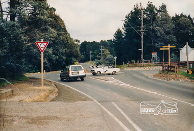 Eltham District Historical Society Inc
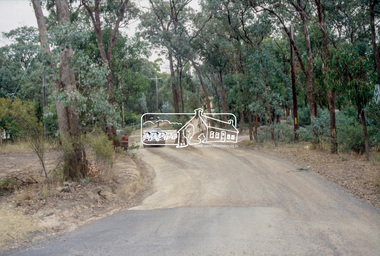
Photograph, Intersection of Kangaroo Ground-St Andrews Road with Rodger Road and Church Road, Panton Hill, c. Oct 1987, 1987
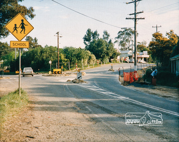
... roundabouts ...Date based on other similar display panels visible in images of the Shire of Eltham display at the Eltham Community Festival, 7 November 1987. Colour photographinfrastructure, display panel, eltham festival, shire of eltham, kangaroo ground-st andrews road, panton hill, roads, roundabouts, rodger road, church road -
 Eltham District Historical Society Inc
Photograph, Panton Hill Store near the intersection of Merritts Road and Kangaroo Ground-St Andrews Road, Panton Hill, c. Oct 1987, 1987
... Roundabouts ...Date based on other similar display panels visible in images of the Shire of Eltham display at the Eltham Community Festival, 7 November 1987.Colour photographdisplay panel, eltham festival, infrastructure, shire of eltham, bishops road, general store, kangaroo ground-st andrews road, merritts road, panton hill, roads, roundabouts -
 Eltham District Historical Society Inc
Photograph, Panton Hill Store near the intersection of Merritts Road and Kangaroo Ground-St Andrews Road, Panton Hill, c. Oct 1987, 1987
... roundabouts ...Date based on other similar display panels visible in images of the Shire of Eltham display at the Eltham Community Festival, 7 November 1987.Colour photographdisplay panel, eltham festival, infrastructure, shire of eltham, bishops road, general store, kangaroo ground-st andrews road, merritts road, panton hill, roads, roundabouts -
 Melbourne Tram Museum
Slide - Set of 2, Keith Kings, 8/08/1959 12:00:00 AM
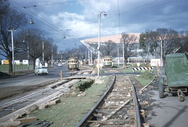
Set of two Colour slide, Kodak, fawn cardboard of the reconstruction of Swan St during August 1959. .1 - Trams 308 (route 74) and 252 (route 77) on temporary track laid through the traffic roundabout at corner of Batman Ave and Swan St. Photo dated 8/8/1959. Has the Olympic Swimming pool in the background. .2 - Tram 353 (route 77) on temporary track in Swan St just before the then new crossover and then back onto temporary track. Photographed 29/9/1959. Slide Number K(d)(282) and K(c)(278)Extensive handwriting on rear in ink and that it was photographed at 1/60, F4.5 and 1/120 at f4. Both slides have in pencil 'WJW" in the top right hand corner.trams, tramways, trackwork, swan st, batman ave, route 77, route 74, crossover, w2 class, tram 308, tram 252, tram 353 -
 Port Melbourne Historical & Preservation Society
Photograph - Bridge Street, Port Melbourne, 1970 - 2005
Photographic images of properties in Port Melbourne. Image may have been taken by a PMHPS member or scanned from a past resident or taken for real estate sale purposes. Bridge Street: Numbers - 22; 44; 46; 48; 49; 51; 52; 53; 55; 57; 59; 63; 75; 81; 92; 94; 219; 221; 223; 225; 227; 229; 231; 233; 234; 235; 236; 237; 239; 241; 243; 245; 247; 249; 251; 253; 255; 257; 259; 261; 263; 265; 267; 269; 271; 273 Also several roundabout viewsbuilt environment - domestic, bridge street, woodruff terrace -
 Buninyong & District Historical Society
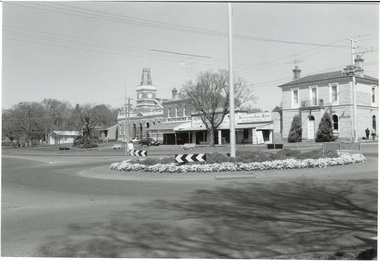
Photograph - Original B/W photograph, Mr Clive Brooks, Streetscape of Learmonth St., Buninyong, looking over roundabout to Town Hall and businesses, 18th September 1993
Part of a photographic record of Buninyong township. The buildings range from 1960s back to 1896, 1887, 1866, to a remnant of 1855, hidden within the shop of D. Brown electrician, consequently reflecting much alteration and change when compared to earlier photos.The streetscape is of historic significance, recording the detail of the streetscape in 1993. Many of the buildings have since undergone significant renovation/change.Streetscape of Learmonth St., Buninyong, looking over roundabout to Town Hall and businesses. Elm trees in the grounds of the Uniting (formerly Presbyterian) Church are seen in the background. Buildings are the fire station, council offices, Town Hall, Whykes Butchers, M. & D. Brown electrician, Buninyong Cake Shop and former bank, now a residence. Oak trees are in front of the council offices and shire hall. One tree planted in 1959 to mark the occasion of the connection of a water supply to Buninyong. A variety of elm is at the end of the row outside the Bank, now a residence. Junipers on each side of the former bank door was planted c1970.learmonth st, buninyong, bank, cake shop, m & d brown, electrician, whykes butchers, whykes, town hall, council offices, fire station -
 Eltham District Historical Society Inc
Journal - Newsletter, Nillumbik Shire Council, Nillumbik News, October 2000
Christmas 2001 articles include: Governor of Victoria re-dedicates KG War Memorial Tower Election details (2002) Summer at the Diamond Creek Pool Community Safety Expo Nillumbik Festival of the Arts: ‘art, caught in the act’ 22 Feb to 3 Mar 2002 Neighbourhood Character Study out for comment Plans to revive St Andrews Market site Integrated Transport Strategy seeks less car usage Eltham Festival Album Rural connector roads strategy Rural Collector Roads to be Sealed Roundabout funding for Diamond Creek Community Fireguard helps prepare for fire Planning for bush fire this summer Capital Works projects on track for 2001-2002 Eltham Town Square opens council newsletters, nillumbik news, nillumbik shire council -
Stawell Historical Society Inc
Photograph, Aerial Photos of Stawell from a Hot Air Balloon 1992 -- 12 Photos
Series of 12 Aerial Photos of Stawell. Hot Air Balloon, October 1992 1. Cnr. Maude St & Grant Street 2. Maude St Napier Street & Railway cutting 3. Trotting Track 4. Roundabout Wimmera & Sloane Street 5. Florence Street towards Cato Lake & Park 6. Grampians Range with Lake Lonsdale near center 7. Gold Reef Mall looking West 8. Church Street looking West 9. Looking towards Black Range 10. Moonie Dams Darlington Road Leisure Complex 11. Stawell Gold Mine Evaporations Dams, Stawell Water Reservoirs, Moonie Dams 12. Darlington Road looking towards Black RangeSeries of 12 colour photographs from the Air.stawell -
 Eltham District Historical Society Inc
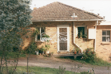
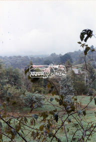
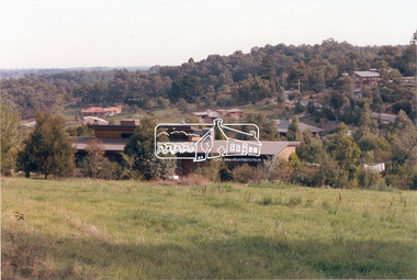
Photograph, 218 Pitt Street, Eltham, c.1985, 1985c
House was rented by Kim Tarpey between October 1983 and June 1985. It was one of the buildings originally part of Birds Orchard. Harold Bird was her landlord, a retired primary school teacher who, when she knew him was driving the mobile library bus. Her partner had him as a teacher at Montmorency Primary in grade 4. The house was next door to what is now a bushland reserve near the Pauline Toner Reserve. It was on the corner of Pitt and Arthur St - the driveway was near the roundabout and went off to the right of the driveway that now belongings to 220 Pitt street and which was bushland at the time. It was sold in 1985 and consequently demolished, a large house has replaced it. It was situated approximately where the front door of No. 218 is nowadays with the facade roughly in line with the now garage wall to the left of this front door.Digital file only - scanned from personal photo album on loan (27 images) List of images EDHS_04644-1.tif Kitchen window looking towards Eucalyptus Road, 218 Pitt Street, Eltham, c.1985 EDHS_04644-2.tif 218 Pitt Street, Eltham, c.1985 EDHS_04644-3.tif 218 Pitt Street, Eltham, c.1985 EDHS_04644-4.tif Kitchen looking towards Pitt Street Reserve, 218 Pitt Street, Eltham, c.1985 EDHS_04644-5.tif 218 Pitt Street, Eltham, c.1985 EDHS_04644-6.tif Bathroom walkway/laundry, 218 Pitt Street, Eltham, c.1985 EDHS_04644-7.tif 218 Pitt Street, Eltham, c.1985 EDHS_04644-8.tif 218 Pitt Street, Eltham, c.1985 EDHS_04644-9.tif 218 Pitt Street, Eltham, c.1985 EDHS_04644-10.tif 218 Pitt Street, Eltham, c.1985 EDHS_04644-11.tif 218 Pitt Street, Eltham, c.1985 EDHS_04644-12.tif 218 Pitt Street, Eltham, c.1985 EDHS_04644-13.tif 218 Pitt Street, Eltham, c.1985 EDHS_04644-14.tif 218 Pitt Street, Eltham, c.1985 EDHS_04644-15.tif 218 Pitt Street, Eltham, c.1985 EDHS_04644-16.tif 218 Pitt Street, Eltham, c.1985 EDHS_04644-17.tif Lounge window looking towards Mount Pleasant Road, 218 Pitt Street, Eltham, c.1985 EDHS_04644-18.tif Fire place in lounge, 218 Pitt Street, Eltham, c.1985 EDHS_04644-19.tif Fire place in lounge, 218 Pitt Street, Eltham, c.1985 EDHS_04644-20.tif View from lounge room window looking towards corner of Eucalyptus and Mount Pleasant roads, 218 Pitt Street, Eltham, c.1985 EDHS_04644-21.tif View from lounge room window looking towards corner of Eucalyptus and Mount Pleasant roads, 218 Pitt Street, Eltham, c.1985 EDHS_04644-22.tif View from lounge room looking towards Pitt Street and Wattle Grove, 218 Pitt Street, Eltham, c.1985 EDHS_04644-23.tif View from lounge room looking towards Pitt Street and Wattle Grove, 218 Pitt Street, Eltham, c.1985 EDHS_04644-24.tif 218 Pitt Street, Eltham, c.1985 EDHS_04644-25.tif Back garden showing previous tank stumps. There was a hole in the wall where a possum got through, 218 Pitt Street, Eltham, c.1985 EDHS_04644-26.tif View from back fence looking towards Pitt Street and Wattle Grove, 218 Pitt Street, Eltham, c.1985 EDHS_04644-27.tif View from back fence on to Eucalyptus Road. Pitt Street Reserve to the right, 18 Pitt Street, Eltham, c.1985218 pitt street, eltham, houses, birds orchard, harold bird, kim tarpey, eucalyptus road -
 Eltham District Historical Society Inc
Photograph, View from lounge room looking towards Pitt Street and Wattle Grove, 218 Pitt Street, Eltham, c.1985, 1985c
House was rented by Kim Tarpey between October 1983 and June 1985. It was one of the buildings originally part of Birds Orchard. Harold Bird was her landlord, a retired primary school teacher who, when she knew him was driving the mobile library bus. Her partner had him as a teacher at Montmorency Primary in grade 4. The house was next door to what is now a bushland reserve near the Pauline Toner Reserve. It was on the corner of Pitt and Arthur St - the driveway was near the roundabout and went off to the right of the driveway that now belongings to 220 Pitt street and which was bushland at the time. It was sold in 1985 and consequently demolished, a large house has replaced it. It was situated approximately where the front door of No. 218 is nowadays with the facade roughly in line with the now garage wall to the left of this front door.Digital file only - scanned from personal photo album on loan218 pitt street, eltham, houses, birds orchard, harold bird, kim tarpey, eucalyptus road -
 Eltham District Historical Society Inc
Photograph, View from back fence looking towards Pitt Street and Wattle Grove, 218 Pitt Street, Eltham, c.1985, 1985c
House was rented by Kim Tarpey between October 1983 and June 1985. It was one of the buildings originally part of Birds Orchard. Harold Bird was her landlord, a retired primary school teacher who, when she knew him was driving the mobile library bus. Her partner had him as a teacher at Montmorency Primary in grade 4. The house was next door to what is now a bushland reserve near the Pauline Toner Reserve. It was on the corner of Pitt and Arthur St - the driveway was near the roundabout and went off to the right of the driveway that now belongings to 220 Pitt street and which was bushland at the time. It was sold in 1985 and consequently demolished, a large house has replaced it. It was situated approximately where the front door of No. 218 is nowadays with the facade roughly in line with the now garage wall to the left of this front door.Digital file only - scanned from personal photo album on loan218 pitt street, eltham, houses, birds orchard, harold bird, kim tarpey, eucalyptus road -
 Eltham District Historical Society Inc
Photograph, View from back fence on to Eucalyptus Road. Pitt Street Reserve to the right, 18 Pitt Street, Eltham, c.1985, 1985c
House was rented by Kim Tarpey between October 1983 and June 1985. It was one of the buildings originally part of Birds Orchard. Harold Bird was her landlord, a retired primary school teacher who, when she knew him was driving the mobile library bus. Her partner had him as a teacher at Montmorency Primary in grade 4. The house was next door to what is now a bushland reserve near the Pauline Toner Reserve. It was on the corner of Pitt and Arthur St - the driveway was near the roundabout and went off to the right of the driveway that now belongings to 220 Pitt street and which was bushland at the time. It was sold in 1985 and consequently demolished, a large house has replaced it. It was situated approximately where the front door of No. 218 is nowadays with the facade roughly in line with the now garage wall to the left of this front door.Digital file only - scanned from personal photo album on loan218 pitt street, eltham, houses, birds orchard, harold bird, kim tarpey, eucalyptus road -
![Photograph - Digital image, Kelly Garden Supplies [Greensborough], 02/05/2013](/media/collectors/4f729f5697f83e03086015b8/items/5729bced2162f108e8de6b52/item-media/5729bd212162f108e8de74aa/item-fit-380x285.jpg) Greensborough Historical Society
Greensborough Historical SocietyPhotograph - Digital image, Kelly Garden Supplies [Greensborough], 02/05/2013
This photograph of the former site of Kelly Garden Supplies was taken in 2013 to show changes over 40 years, based on Ron Reynold’s sketches in the 1973 publication “Greensborough and Greenhills” published by Cypress Books. The site is now part of the Civic roundabout at the top of the Greensborough By-pass. Civic Drive was associated with the building of Diamond Valley Council Offices opened by Governor Rohan Delacombe on 26/2/1972. Previously it was known as Kelly's Track which wound its way around to a house that overlooked the aqueduct bridge. Kelly's Sandpit (quarry) was the local go to place to obtain road, driveway fill and red sand for local construction. For 80 years previous Kelly's quarry supplied sand to the greater Melbourne area for the surfacing of school grounds, parks etc. Digital copy of colour photograph.greensborough and greenhills, civic drive greensborough, kelly garden supplies, ron reynolds -
 Eltham District Historical Society Inc
Slide - Photograph, Nyora Road, Eltham, c.1993
The east end of Nyora bewteen Stokes Place and Reynolds Road was unsealed. This section was only a fire access track as evidenced by the trees growing in the middle of the road. Real Estate agents would advertise homes as down a (dusty) country lane. The Nyora Road Resident Action Group arose to address concerns with Council regarding the dangerous conditions and traffic from outside the area using it as a 'rat-run' to avoid Main Road. Council traffic monitors showed that the amount of traffic was only 20% less than that of Mt Pleasant Road. The Action Group wanted the road closed at reynolds Road however Council elected to install speed calming devices along the sealed section between Stokes Place and Eucalyptus Road. Chicanes were added at several locations and a roundabout installed at Stokes Place in 2004. This remaining dirt section was sealed post 2004.35mm colour positive transparency Mount - Black and Whiteinfrastructure, roads, eltham, nyora road -
 Greensborough Historical Society
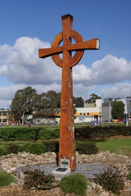
Photograph - Digital image, Jasmin Burge, Cross 2010, 30/07/2010
Photograph of Cross carved by Kevin Gilders and completed in 2010. Inscription on plaque: 'This Cross commemorates the 30th anniversary of Loyola College Watsonia. It is sculptured form the wood of the cedar tree that once stood on these grounds in the roundabout in front of the Loyola Jesuit House of Studies and Novitiate building from 1934-2009. The Cross was unveiled by College Captains Adam Leary and Julia Cosgrave; Fr Steven Rigo; President of the Association of Canonical Administrators and Mr Joseph Favrin; College Principal. It was blessed by Fr Gerry Healy SJ at the College celebration of the feast of St Ignatius held on July 30th 2010. Part of a collection of photographs of Loyola College; Grimshaw Street Watsonia; established 1980 on the site of the Loyola Seminary. The College purchased the original building in 2002. These photographs of the original building and grounds were taken by GHS member Jazz Burge in June 2012.Digital copy of colour photograph.loyola college