Showing 251 items matching "stawell area"
-
 Hume City Civic Collection
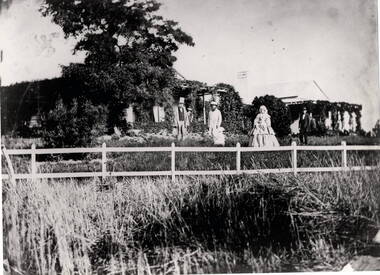
Photograph, Woodlands Homestead, c1858 - 59
The photograph is of the Woodland Homestead at Bulla which was sited along the Moonee Ponds Creek. William Pomroy Greene and his wife Anne, emigrated from Scotland and arrived in the Port Phillip area in December 1842.. He acquired the Crown land at Gellibrand Hill in 1843 and built the prefabricated homestead which became known as Woodlands. The people in the photograph, taken about 1859 - 60, are L- R: Possibly Sir Willian Stawell, ?, little Anne Catherine Greene at 2 years, Rawdon Greene, Mrs. Greene and Smith ( a butler).The Greene family were one of the early European settlers to acquire land in the Bulla Bulla district. The Woodlands property is now a national park and the significant Gellibrand Hill is within the park.A black and white photograph of 3 men, a lady and a child standing in a garden in front of a homestead. A wooden post and rail fence is in the foregroundwoodlands homestead, greene family -
 Hume City Civic Collection
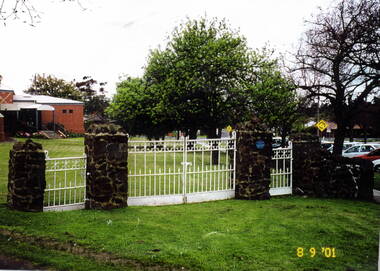
Photograph, St. Andrews Uniting Church gates, 8th September 2001
These are the original wrought iron gates which served as the entrance to St. Andrews Uniting Church, formerly St.Andrews Presbyterian Church. They were erected there in 1922 and were made at H.V.McKay's Sunshine Harvester foundry, at Sunshine. H.V McKay was a member of the Presbyterian Church in Sunbury. Originally the gates opened onto Stawell Street, which ran at an angle between O'Shanassy and Barkly Streets. Apart from a small area leading to the Memorial Hall the rest of Stawell Street has been incorporated in the Village Green in Sunbury.The gates were restored and erected on their original site in 2000. A scanned coloured photograph of white painted wrought iron double gates with two smaller gates on either side and supported by stone pillars. A church building is just beyond a grassed area.st. andrews church, st. andrew's uniting church, wrought iron gates -
 Sunbury Family History and Heritage Society Inc.
Photograph
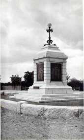
The Sunbury War Memorial is sited in a grassed reserve at the intersection of Stawell and Macedon Streets in Sunbury. At its initial installation, the names of Sunbury ex-servicemen who had seen battle in World Wars 1 and 2 were listed on the four plaques. In later years the names of other servicemen who have fought in recent battles have been added to the memorial. On Anzac Day a service takes place at the memorial and is attended by many of the townspeople.The war memorial in Stawell Street is one of Sunbury's important heritage structures and commands an important position in the town.A black and white photograph with a cream border of a memorial set in an open area. The memorial has been set on a pedestal of three steps. a lamp supported by a metal tripod with four smaller lamps below the main one is on top of the memorial. -
 Stawell Historical Society Inc
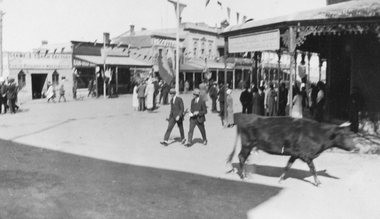
Photograph, Main Street Stawell corner of Wimmera Street with Stabbs Coach Building visable c1920's, 1920
Sepia photo of Stawell Main Street Scene. Stabb's Coach Building on corner of Wimmera Street visible. C1920's. Possibly Easter bunting hanging in the street.Sepia Photograph of a scene in a commercial area. People in the Street. A Cow in the foreground. Stawell from the side of the P.O. (Nell Kingston)stawell -
 Stawell Historical Society Inc
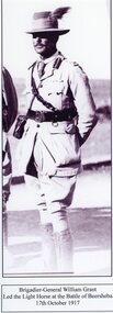
Photograph, Brig-General William Grant
Grant William. Brig-GenMale in Army Uniform WW1. Set in arid area. Brigadier-Generla William Grant, who led the Light Horse at the battle of Beersheba 17 October 1917. Son of E.G GrantBrigadier- General William Grant Led the Light Horse at the battle of Beersheba 17 October 1917.stawell, w.m grant, mititary -
 Stawell Historical Society Inc
Instrument - Realia, Engineering Instruments from Northern Grampians Shire
1: Small cardboard box with lid containing Silver distance Measurer. This was used for Measuring distances on plans.(Planimeter) 2: Cardboard Box without lid containing three plumbobs: One large turned brass: one small turned metal. One circular silver coloured metal complete with string and winding board. These were used to locate survey equipment above a fixed point. 3: Timber ( Vic Ash?) dovetailed box with brass hinged lid and brass swing catches containing plywood templates called railway curves, used for drawing curves on plans. 4: Cardboard box with lid containing Allbrit panimeter in Bakelite/plastic box with silver metal hinges and catches "Shire of Kara Kara" inscribed on the box. The box contains the original Instructions. The Planimeter was used for calculating areas of Irregular shapes and used for estimating quantities from plans of cut and fill projects, as one example. 5: Timber Box with brass hinges and swing catches wand leather carry Strap containing one set of self adjusting level made by E.R. Watts and Son, London England. Paper label on the inside "Shire of Stawell". Also had paper instructions pasted to the inner lid. The level was used for taking Ground Levels. The first 3 have been in use up until the 1990's, when computer drafting took over the role of these instruments with greater speed and accuracy. The dumpy level would have been superseded in the 1980's when automatic levels became cheaper, and were more accurate. stawell -
Stawell Historical Society Inc
Archive, Ararat Districts – Pleasant Creek Division Application for Residence & Business Area 1880
stawell, government -
 Stawell Historical Society Inc
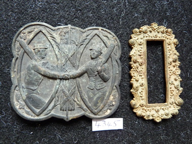
Memorabilia - Realia, c1880's
Mens Metal Belt Clips with Cricket Scene from Armstrong's Area stawell -
 Stawell Historical Society Inc
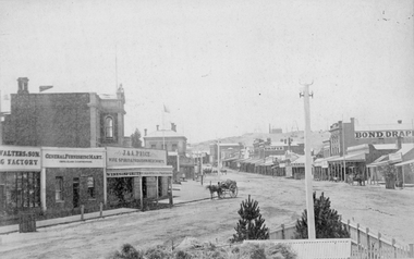
Photograph, Main Street Stawell looking East from the Present War Memorial site 1878
Main St. looking East towards Big Hill from Coffee Palace Verandah over Present War Memorial area. 1878 Businesses from left Walters and Son Factory, General Furnishing Mart, Stawell Town Hall, J. & A. Price Wine Spirits & Provision Merchants, Stawell Post Office. On right south side of Main Street, two-storey wooden Bull & Mouth Hotel, Whiteside Taylors, Carters Boot shop, Lecky Draper, C. Mulcahy Post Office Hotel, G.J. Hewlett Baker & Confectionery, Iron Monger, Victoria House Bond Draper, Town Hall Hotel, J. Richards Fancy Repository. Victorian Views. C. Herbert, Photo. Stawell 1878stawell business streetscape -
 Stawell Historical Society Inc
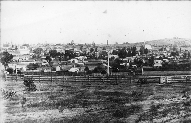
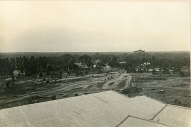
Photograph, Town & Big Hill from King Street area c1900
Town & Big Hill from King Street area. c1900 Market Building in Skene Street visible in left of photo. St Patrick's Church on Right. Rail line and signal pole in foreground of photo across image.stawell, streetscape, panorama -
 Stawell Historical Society Inc
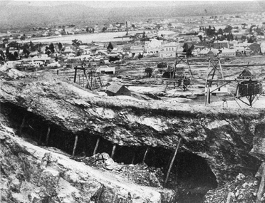
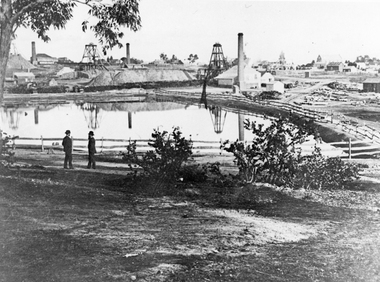
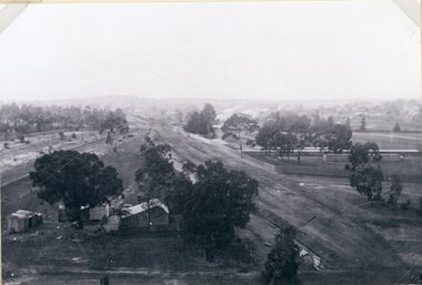
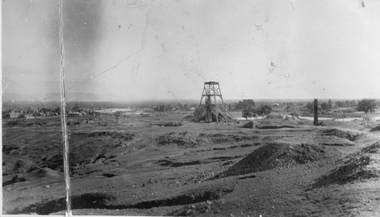
Photograph, Panorama of Mining Scene from Big Hill with the Open cut in foreground
Mining Scene from Big Hill. Open cut in fore ground with support timbers. Whims and poppet heads. Shows back of New Court House in Patrick Street. The flat area in distance is St Georges Crushing Battery settling Dam.Open Cut with supporting timbers in foreground, Various poppet Heads at centre of image. Wimmera Crushing Mill settling dam in distance. Rear of new Court House visiblestawell mining -
 Stawell Historical Society Inc
Photograph, The Pleasant Creek Cross Reef No1 Shaft Panorama of a Mining Scene in the Duke Sands area c1875
Mining Scene Duke Sands area c1875 Behind the tree on left is Extended Cross Mine and on the right is the Oriental Mine. In the centre is the North Cross Mine No1 shaft. In the foreground is one of the Moonlight dams. St Peters Lutheran Church in Scallan Street can be seen on the right horizon. Two mines and workings on other side of Moonies settling dam. Two Gentlemen lower left cornerstawell mining -
 Stawell Historical Society Inc
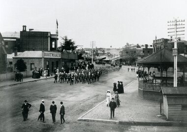
Photograph, Bandsmen leading Senior and Junior Cadets in Main Street Stawell looking East from Memorial Area 1908
Parade of Bandsmen leading Senior and Junior Cadets in Main Street looking East from Memorial Area 1908. Boot makers shop between Town hall and Anglican Church on left Town Hall Hotel and shops on right with band rotunda to right of photo.stawell band pavillion boer war streetscape -
 Stawell Historical Society Inc
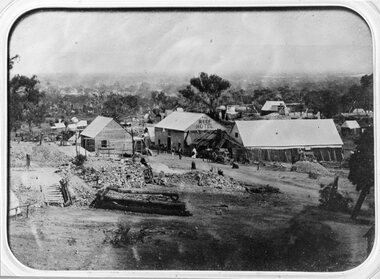
Photograph, The Reef Hotel Pleasant Creek 1858 - 1861 -- note, no Bullock team as in Rees painting
The Reefs Hotel Pleasant Creek. 1858 - 1861 (note, no Bullock team as in Rees painting) Three windlasses over mineshafts can be seen, two on the left and one in front of the assembly hall. Some horse driven Whims can be seen in the background above the Assembly Hall.One of earliest known photographs of Pleasant CreekSeveral buildings in mining area with trees in background, one building labelled The Reefs Hotel. Spoil heaps in foreground with other mining activities . Number of people visible in street.stawell -
 Stawell Historical Society Inc
Photograph, Group Photo of the Harris' at the decorated Mechanic Hall in Great Western 1932
Harris. WM. & Jane – Diamond Wedding Anniversary. Decorations in Mechanics Hall Great Western. 1932 In Great Western Families Book under Harris are similar photo'sBlack and white photo, Showing decorations in Mechanic Hall for Diamond Wedding Anniversary. Floral arrangements on stands . Ceiling swags with diamonds and Bells possibly paper. Closed off area fronted with Diamonds cut out and attached to board. Group includes Ernest Harris & Wife. Decorations in Mechanics Hall Great Western for Diamond Wedding 1932 William Harris And Jane Harris ( Nee Colley) 21 October 1932stawell -
 Stawell Historical Society Inc
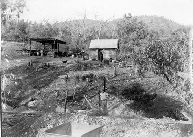
Photograph, Telford Mining activity with a Slab shed and work area in the Bushland c1902
... Stawell Historical Society Inc 46 Longfield St Stawell ...Telford Mining activity Slab shed and work area in Bushland c1902stawell gold -
 Stawell Historical Society Inc
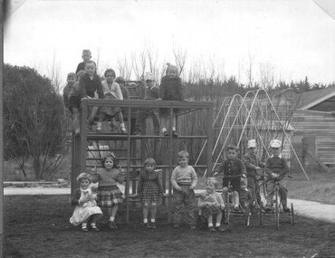
Photograph, Lady Brooks Free Kindergarten in Sloane Street Stawell with children in the play area at the back
Lady Brooks Free Kindergarten Sloane Street Stawell ??? showing children in play area at back of buildingstawell education -
 Stawell Historical Society Inc
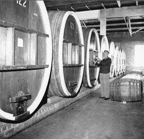
Photograph, Seppelts Storage Area in Great Western with worker is Mr Leo Hurley
... Hurley a long time employee Stawell Winery Seppelts Storage Area ...Seppelts Great Western Storage Area. Worker is Mr Leo Hurley a long time employeestawell winery -
 Stawell Historical Society Inc
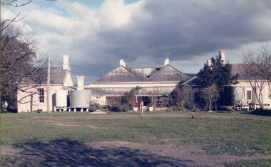
Photograph, The rear Area of Ledcourt Homestead c1991 -- Coloured
... Stawell Historical Society Inc 46 Longfield St Stawell ...Colour photo of rear of Ledcourt Homestead c1991stawell -
 Stawell Historical Society Inc
Photograph, North Western Woollen Mills -- Land Area
... grampians North Western Woollen Mills Scene Mills Area Stawell ...North Western Woollen Mills Scene Mills Areastawell industry -
 Stawell Historical Society Inc
Photograph, North Western Woollen Mills -- Land Area
... grampians North Western Woollen Mills Scene Mills Area Stawell ...North Western Woollen Mills Scene Mills Areastawell industry -
 Stawell Historical Society Inc
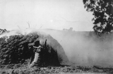
Photograph, Charcoal Burning in Fyans Creek area
... grampians Charcoal Burning in Fyans Creek area Stawell Charcoal ...Charcoal Burning in Fyans Creek areastawell -
 Stawell Historical Society Inc
Photograph, Charcoal Burning in Fyans Creek area with part of the kiln formation
Charcoal Burning in Fyans Creek area. Shows part of kiln formation.stawell -
 Stawell Historical Society Inc
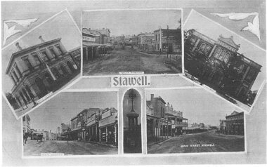
Postcard, Main Street showing area in front of Town Hall Hotel c 1940 -- 2 Photos -- Postcards -- 1 Coloured
Main Street showing area in front of Town Hall Hotel c1940stawell streetscape -
 Stawell Historical Society Inc
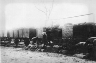
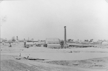
Photograph, Grant and Lamont Crushing Plant for Oriental & North Cross Reef Gold Mining Company 1867
Grant and Lamont Crushing Plant located in area of present swimming Pool.Settling dam in front of shed. Chimney on right. Three men just visible in front of shed. Houses to right. Big hill on left.stawell mining -
 Stawell Historical Society Inc
Memorabilia - Realia, c1880's
Women's Metal Belt Clip with Raised Flower Pattern from Armstrong's Area stawell -
 Stawell Historical Society Inc
Photograph, Sloane's & Scotchmans Mining Co's Remains of Poppet Head, Chimney & Engine Mounts. 1928
Sloane's & Scotchman Mining Co remains Poppet Head Chimney and Engine Mounts.Damaged B/W image showing heavily eroded mining area with mine at centre distance. mining, panorama -
 Stawell Historical Society Inc
Drawing, Town & Big Hill from King Street area -- Sketch
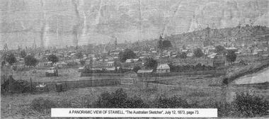
... grampians Town & Big Hill from King Street area stawell A Panoramic ...Town & Big Hill from King Street areaBlack and White sketch drawn from King Street area St Patrick's church just right of centre. Poppet heads on skyline. A Panoramic View of Stawellstawell -
 Stawell Historical Society Inc
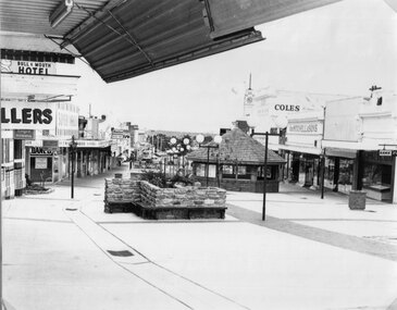
Photograph, Main Street looking West from Fountain Area down Gold Reef Mall c1984
Main Street looking West from Fountain Area down Gold Reef Mall Shows Rotunda and planter boxes. Bull and Mouth Hotel at left of photo Geo Mitchell at right. C1984stawell businesses, streetscape -
 Stawell Historical Society Inc
Photograph, Gold Reef Mall Post Office & surrounds c1985 -- 2 Photos -- Coloured
Gold Reef Mall Post Office c1985 looking north. Two colour photographs one shows grassed area in front of Post Office and Langford's old pharmacy., second shows community Calendar plant holders and children's play area, State bank on left, Monahan's Pharmacy on right.. stawell main street streetscape