Showing 254 items matching "stawell road"
-
 Stawell Historical Society Inc
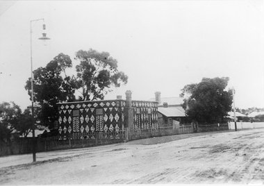
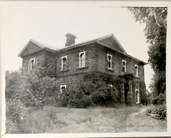
Photograph, Diamond House
Diamond House Stawell. This unique house was built by John Hearne between 1866-1868 using white quartz stone gathered on Church Hill opposite. Mr. Hearne showed considerable skill and patience in construction as the stones had to be carefully cut & fitted into uniformity which has lasted 130 years. Its is said not a nail was used. It became the Diamond house restaurant in 1932. The photo was taken in 1903.Two Black & white photograph of Diamond House including neighboring houses. There is a light post on the left hand side and what appears to be a dirt road in front of the houses. Photo taken in 1903.stawell -
 Stawell Historical Society Inc
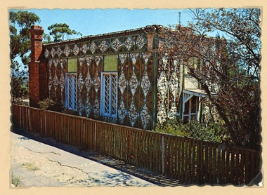
Photograph, Diamond House -- Coloured
Stawell Diamond House post cards by NucolorVue productions. Two colour postcards of the Diamond House. There is also a more recent colour photograph of the Diamond House in Album 8. The photo in Album 8 was taken from the road with a car just visible on the road it also has a Restaurant sign on the side of the building.A Nu-Color-Vue of Australia ST7- Nucolorvue Productions Pty. Ltd. Copyright stawell -
 Stawell Historical Society Inc
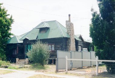
Photograph, Log Cabin c 2000 -- Coloured
Colour photo Log Cabin Darlington Road built by J Wharrie. This coloured print taken in c 2000.Colour Photograph of the Log cabin taken in 2000. The roof is iron and a green colour. The front entrance porch has been removed and a low fence at the front. The top of the chimney has also changed.stawell dwelling -
 Stawell Historical Society Inc
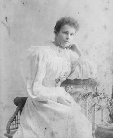
Photograph - Portrait, Young Woman
Huttley - Martin FamilyB/W Studio Portrait: Young Woman in white dress with puffed full length sleeves Sitting on chair leaning on whicker tableW. mason & Co. 150 Bridge Road, Richmond. Melbournehuttley, martin -
 Stawell Historical Society Inc
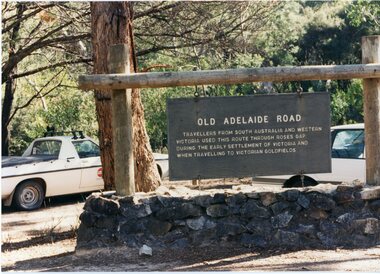
Photograph, Old Adelaide Road - Roses Gap, 29/04/1997
2 Colour Photographs; 1 Showing Old Adelaide road sign. 1 Large group of people outside.roses gap -
 Stawell Historical Society Inc
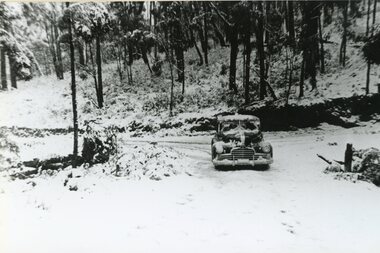
Photograph, Car on the road in the Grampians with Snow 1949
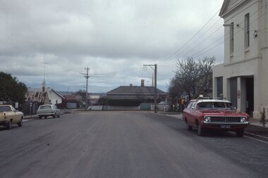
... Stawell Historical Society Inc 46 Longfield St Stawell ...Car on road in Grampians Snow Scenes July 19 1949halls gap -
 Stawell Historical Society Inc
Book - Guide Book, The Emigrant's Friend
Faxsimile Reprint of 1848 booklet printed in London J. Allen warwick, Paternoster Row: D. Francis Mile End Road. May be had of all Booksellers. Inlcudes what Emigrant must provide at minimum when on passage to the colonies.Paper Back, Fawn cover: Brown print Seals of Australia, New Zealand, Van Dieman's Land, and the Seal of Swan River.Seal of New Zealand Seal of Australia [Picture of Seal] [Picture of Seal] The Emigrants friend or Authentic Guide to South Australia Including Sydney: Port Philip or Australia Felix: Western Australia, or Swan River Colony: New South Wales: Van Dieman's Land; and New Zealand original published in London in 1848. Recreated by Reader's Digest Sydney [Picture of Seal] [Picture of Seal] Seal of Van Dieman's Land [Seal of Swan River] -
 Stawell Historical Society Inc
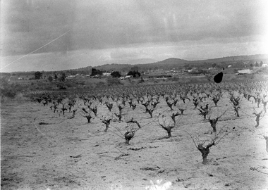
Photograph, View of Great Western, early 1900's
Digital Photo taken from glass slide by Geoff McMillan, Cooper Street Stawell and reproduced as a photo - printed at Stawell Historical Society 2019Black & White Photo - a view from Western View Road, Great Western, looking west over Great Western itself - the back of the Great Western Hall, hotel etc. St Peter's vineyard building near the top right. winery, wine making, panorama -
 Stawell Historical Society Inc
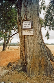
Photograph, Master Willie Himphrey's grave -- died 1857 -- son of Pioneers, Mr Joseph Humphrey & Mrs Frances Humphrey nee Unknown, 2020
Colour photograph of signs on tree marking Childs grave of Willie Humphrey. Died 1857 aged 8 son of pioneers Joseph & Francis Humphrey. Frenchmans - Navarre Road Barkly -
 Stawell Historical Society Inc
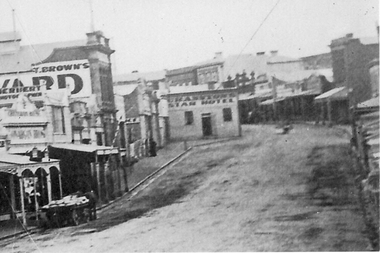
Photograph, Enlargement of Catalogue number 0541 of Main Street looking East featuring the Star Hotel, 1890's
Enlargement of right hand side of photo 0541. Top end of Main St. looking East towards Big Hill. From left Herbert Photographic, T Brown, Star Hotel on bend jutting out into middle of road. Mechanics Institute in background. Two Horse wagon in street on left.stawell businesses streetscape -
 Stawell Historical Society Inc
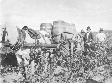
Photograph, Grape Picking in Great Western 1902
B/W photo of three men with a white horse pulling a cart with barrels of grapes just picked. Taken at Arrawatta Vineyard at Irvine's, Great western near Jonathon Gully and German Gully Roads. 1902win, wineries -
Stawell Historical Society Inc
Map, Western Mining Corp / Stawell Joint Venture, Aerial Photo of Wonga Open Cut and Tailings Dam No 2 proposed extension, January 1991
Shows proposed extension No2 Tailings Dam off Lavett Road and proposed Revegetation Corridors Western Mining Corporation Limited Stawell Joint Venturemining, gold, map -
 Stawell Historical Society Inc
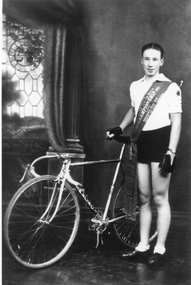
Photograph, Mr Ron Bates 1935 -- Studio Portrait
Ron Bates in Cycling clothing & championship sash across his chest holding onto his bike seat with his right hand. He has cycling gloves on.Bike has Healing written on it. Australian Junior Road Championship 1935 -
 Stawell Historical Society Inc
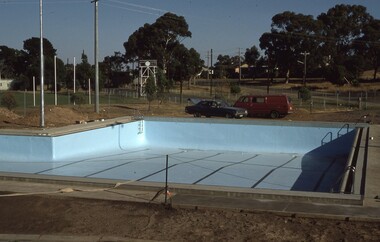
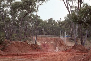
Photograph - Slide, Construction of New Pool
Looking across new pool during constrction to Newington Road. -
 Stawell Historical Society Inc
Photograph, Stawell Gold Mine
... Stawell Historical Society Inc 46 Longfield St Stawell ...looking across mine toward Reefs Road big Hillgold mining -
 Stawell Historical Society Inc
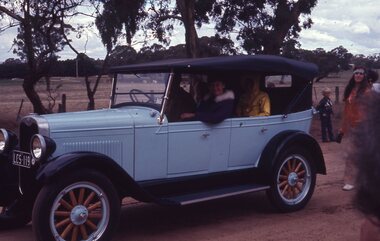
Slide, Ian McCann, Concongella School Parade - Vintage Car
Vintage Car on dirt roadconcongella school parade -
 Stawell Historical Society Inc
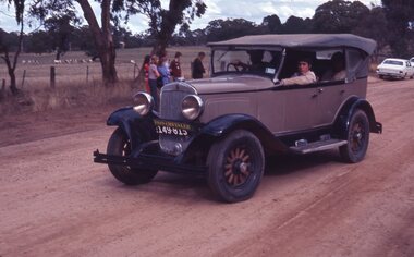
Slide, Ian McCann, Concongella School Parade 1929 Chrysler
A 1929 Chrysler on a dirt road.concongella school parade -
 Stawell Historical Society Inc
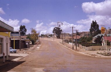
Slide, Ian McCann, Upper Main Street from Partick Street
upper Main Street, from Patrick Street looking towards Big Hill, before road being resealedstawell buildings -
 Stawell Historical Society Inc
Slide, Ian McCann, House butting into centre of Scallan and Byrne street intersection later demolished. Old Fire Station on right
This house was effectively in the middle of Scallan and Byrne Street intersection. Purchased by the council to be demolished c1975 to allow road to be aligned.House in centre of image. Old Fire Station on right looking down Scallan Street. -
Whitehorse Historical Society Inc.
Letter - Correspondence, Shire of Stawell, 1933
A report on the Cost of Government ConferenceA report on the Cost of Government Conference held at the Melbourne Town Hall on 1st August 1933. together with a detailed report from the Stawell TimesA report on the Cost of Government Conferencepolitics and government, shire of stawell -
 Kew Historical Society Inc
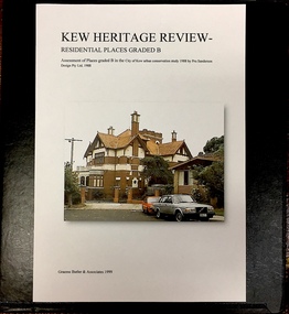
Archive (Sub-series) - Subject File, Kew Heritage Review, Residential Places Graded B, Volume 1, 1999, 1999
Graeme Butler & AssociatesProject FilesProvenance OrderBlack 4-Ring binder that includes research about, and an assessment of buildings previously graded B in the City of Kew Urban Conservation Study 1988 by Pru Sanderson Design Pty Ltd. The files were created by the heritage architect Graeme Butler and the paper files include maps, correspondence, title searches, readings, reviews of prior classifications, newspaper and journal articles, directories etc for each property assessed.graeme butler, heritage reviews - kew, 20 yarra street, 8 yarra street, 33 wills street, 25 wellington street, 11 wellington street, 118 walpole street, 84 walpole street, 83 walpole street, 63 walpole street, 52 walpole street, 51 walpole street, 14 vista avenue, 12 tara avenue, 89 studley park road, 75 studley park road, 44 studley park road, 25 studley park road, 13 studley avenue, 21 stoke avenue, 71 stevenson street, 34 stevenson street, 12 stevenson street, 36 stawell street, 11 second avenue, 3 second avenue, 2 second avenue, 34 rowland street, 21 redmond street, 11 redmond street, 16 queen street, 27 princess street, 82 molesworth street, 28 miller grove, 26 miller grove, 24 miller grove, 24 milfay avenue, 8 milfay avenue, 4 merrion grove, 25 mary street, 24 lister avenue, 2 john street, 9 hume street, 7 hume street, 24 howard street, 20 howard street, 19 howard street, 10 howard street, 2 howard street, 26 holroyd street, 12 holroyd street, 73 high street, 69 high street, 35 high street, 6 high street, 53 harp road, 6 gellibrand street, 48 foley street, 9 eglinton street, 25-27 edgecombe street, 21-23 edgecombe street, 5-7 edgecombe street, 23 dunlop avenue, 167 derby street, 8 denmark street, 1 denmark street, 2 daracomb avenue, 2 danielle place, 340 cotham road, 294 cotham road, 241 cotham road, 221-229 cotham road, 208 cotham road, 193 cotham road, 180 cotham road, 171 cotham road, 167 cotham road, 161 cotham road, 135-137 cotham road, 46 clyde street, 4 cameron court, 1291 burke road, 1223 burke road, 1205 burke road, 5 bowen street, 35-37 belford road, 389 barkers road, 387 barkers road, 311 barkers road, 231 barkers road, 83-85 barkers road, 15 adeney avenue, 6 a'beckett streetgraeme butler, heritage reviews - kew, 20 yarra street, 8 yarra street, 33 wills street, 25 wellington street, 11 wellington street, 118 walpole street, 84 walpole street, 83 walpole street, 63 walpole street, 52 walpole street, 51 walpole street, 14 vista avenue, 12 tara avenue, 89 studley park road, 75 studley park road, 44 studley park road, 25 studley park road, 13 studley avenue, 21 stoke avenue, 71 stevenson street, 34 stevenson street, 12 stevenson street, 36 stawell street, 11 second avenue, 3 second avenue, 2 second avenue, 34 rowland street, 21 redmond street, 11 redmond street, 16 queen street, 27 princess street, 82 molesworth street, 28 miller grove, 26 miller grove, 24 miller grove, 24 milfay avenue, 8 milfay avenue, 4 merrion grove, 25 mary street, 24 lister avenue, 2 john street, 9 hume street, 7 hume street, 24 howard street, 20 howard street, 19 howard street, 10 howard street, 2 howard street, 26 holroyd street, 12 holroyd street, 73 high street, 69 high street, 35 high street, 6 high street, 53 harp road, 6 gellibrand street, 48 foley street, 9 eglinton street, 25-27 edgecombe street, 21-23 edgecombe street, 5-7 edgecombe street, 23 dunlop avenue, 167 derby street, 8 denmark street, 1 denmark street, 2 daracomb avenue, 2 danielle place, 340 cotham road, 294 cotham road, 241 cotham road, 221-229 cotham road, 208 cotham road, 193 cotham road, 180 cotham road, 171 cotham road, 167 cotham road, 161 cotham road, 135-137 cotham road, 46 clyde street, 4 cameron court, 1291 burke road, 1223 burke road, 1205 burke road, 5 bowen street, 35-37 belford road, 389 barkers road, 387 barkers road, 311 barkers road, 231 barkers road, 83-85 barkers road, 15 adeney avenue, 6 a'beckett street -
 Kew Historical Society Inc
Archive (Sub-series) - Subject File, Kew Heritage Review, Residential Places Graded B, Volume 2, 1999, 1999
Graeme Butler & AssociatesProject FilesProvenance OrderBlack 4-Ring binder that includes research about, and an assessment of buildings previously graded B in the City of Kew Urban Conservation Study 1988 by Pru Sanderson Design Pty Ltd. The files were created by the heritage architect Graeme Butler and the paper files include maps, correspondence, title searches, readings, reviews of prior classifications, newspaper and journal articles, directories etc for each property assessed. graeme butler, heritage reviews - kew, 25 mary street, 4 merrion grove, 24 milfay avenue, 24 miller grove, 26 miller grove, 28 miller grove, 82 molesworth street, 27 princess street, 16 queen street, 20 yarra street, 84 walpole street, 118 walpole street, 11 wellington street, 83 walpole street, 25 wellington street, 8 yarra street, 33 wills street, 63 walpole street, 14 vista avenue, 89 studley park road, 12 tara avenue, 75 studley park road, 21 redmond street, 52 walpole street, 51 walpole street, 71 stevenson street, 34 rowland street, 21 stoke avenue, 34 stevenson street, 44 studley park road, 25 studley park road, 13 studley avenue, 2 second avenue, 11 second avenue, 3 second avenue, 36 stawell street, 12 stevenson streetgraeme butler, heritage reviews - kew, 25 mary street, 4 merrion grove, 24 milfay avenue, 24 miller grove, 26 miller grove, 28 miller grove, 82 molesworth street, 27 princess street, 16 queen street, 20 yarra street, 84 walpole street, 118 walpole street, 11 wellington street, 83 walpole street, 25 wellington street, 8 yarra street, 33 wills street, 63 walpole street, 14 vista avenue, 89 studley park road, 12 tara avenue, 75 studley park road, 21 redmond street, 52 walpole street, 51 walpole street, 71 stevenson street, 34 rowland street, 21 stoke avenue, 34 stevenson street, 44 studley park road, 25 studley park road, 13 studley avenue, 2 second avenue, 11 second avenue, 3 second avenue, 36 stawell street, 12 stevenson street -
 Kew Historical Society Inc
Archive (Sub-series) - Subject File, Kew Heritage Review, Residential Places Graded B, Volume 3, 1999, 1999
Graeme Butler & AssociatesProject FilesProvenance OrderBlack 4-Ring binder that includes research about, and an assessment of buildings previously graded B in the City of Kew Urban Conservation Study 1988 by Pru Sanderson Design Pty Ltd. The files were created by the heritage architect Graeme Butler and the paper files include maps, correspondence, title searches, readings, reviews of prior classifications, newspaper and journal articles, directories etc for each property assessed.graeme butler, heritage reviews - kew, 4 cameron court, 2 hodgson street, 20 fellows street, 26 fellows street, 23 highbury grove, kew lunatic asylum, kew mental hospital, willsmere, 36 stawell street, 13 studley avenue, 16 studley avenue, 20 studley avenue, raheen, studley park road, beament house, 33 uvadale road, 20 yarra streetgraeme butler, heritage reviews - kew, 4 cameron court, 2 hodgson street, 20 fellows street, 26 fellows street, 23 highbury grove, kew lunatic asylum, kew mental hospital, willsmere, 36 stawell street, 13 studley avenue, 16 studley avenue, 20 studley avenue, raheen, studley park road, beament house, 33 uvadale road, 20 yarra street -
Kew Historical Society Inc
Archive (Sub-series) - Subject File, Kew Historical Society, Houses [Kew], 1980
Various partiesReference, Research, InformationSecondary Values (KHS Imposed Order)Assorted printed materials, some published, such as: ‘What House is That? A guide to Victorian housing’ (Heritage Victoria, 2004), and guidelines for researching the history of a house (Fact Sheet, City of Boroondara). There is an article from the Progress Press about the demolition of Ellesmore, 80 Princess Street in 1977 (the article includes photographs of the demolition), Elizabeth Mackie’s notes on Myrtle Hill, and an article on the restoration of Mynda, Molesworth Street that was published in the Trust News (1987). Mrs Sewell of Stawell Street wrote handwritten notes/recollections about Cradley in Studley Park Road in 1981. In the photocopy about Ellesmore, there is also a separate article on the proposed replacement of the Walmer Street Bridge. There is also correspondence and an article on Stanhope on the corner of Burke and Cotham Roads. The file includes general real estate information and data.kew historical society - archives, kew - history, myrtle hill (kew), ellesmore - 80 princess street - kew (vic), mynda - molesworth street - kew (vic), stanhope - burke road - cotham road - kew (vic), cradley - studley park road - kew (vic), 17 queen street - kew (vic.)kew historical society - archives, kew - history, myrtle hill (kew), ellesmore - 80 princess street - kew (vic), mynda - molesworth street - kew (vic), stanhope - burke road - cotham road - kew (vic), cradley - studley park road - kew (vic), 17 queen street - kew (vic.) -
 Kew Historical Society Inc
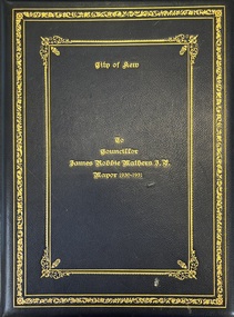
Award - To James Robbie Mather J.P. Mayor 1930-1931
James Robbie Mathers was born in Pleasant Creek [Stawell] in 1867 to James Allen Mathers, a storekeeper and former councillor. He was later to become a storekeeper in Gippsland and then at Heywood, near Portland. Following a move to Melbourne, he established a real estate business. He initially lived in Hawthorn, before moving his business to Kew where he traded as Mathers & McMillan, 136 Cotham Road, and later at 283 Burke Road. For a short time, the family resided at Landene, in Cotham Road. They were to finally move to Rosalea, in Dale Street, Deepdene. Following the death of Cr Henry Kellett in 1924, Mathers was elected unopposed as representative of College Ward. Elected Mayor in September 1930, he convened a meeting of citizens in the Town Hall in Walpole Street to form a local unemployment relief committee. His social initiatives included handing over council-owned premises in Brougham Street, the building re-purposed as a workshop for the unemployed, who were also granted free use of the Kew Municipal Baths. The Mayoress, Jean Mathers, set to work raising funds through charity balls, and also raised funds for St Anthony’s Orphanage in Wellington Street. James Robbie Mathers died on 8 April 1945. He was buried at Box Hill Cemetery. This rare civic testimonial is historically significant, especially locally, as it contains the signatures of all present councillors and parliamentarians representing the City of Kew as well as the names and signatures of leaders of local churches, schools, public officials and leaders of community groups.Boxed presentation folder and correspondence presented to the retiring Mayor of Kew, James Robbie Mather, in 1931. The book is leather bound with gilt lettering on the front. The 4 page testimonial includes and hand written statements about his contribution to Kew and its civic life. Other pages are signed by councillors, parliamentarians and community leaders.james robbie mathers, mayors of kew, civic testimonials -
 Kew Historical Society Inc
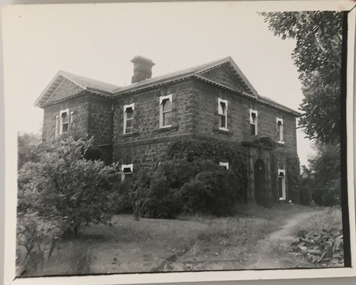
Photograph - 'D'Estaville', Barry Street, c. 1980
D'Estaville was built for Sir William Stawell in Studley Park, Kew in the 1850s. Later occupants include the artist Alma Figuerola. Part of a photographic series which is historically and aesthetically significant. The photographs record the interiors and exteriors of D'Estaville, an historic Kew mansion in the 1960s, and also its owner, Alma Figuerola, a pupil of Max Meldrum, and a notable Melbourne artist who lived in Kew.D'Estaville, Barry Street, Kew, This view of the bluestone house is taken from the western side. The front entrance, originally facing Studley Park Road is set into the southern side of the house.d'estaville -- 7 barry street -- kew (vic), alma figuerola -- melbourne artists -
 Kew Historical Society Inc
Photograph - 'D'Estaville', Barry Street, c. 1980
D'Estaville was built for Sir William Stawell in Studley Park, Kew in the 1850s. Later occupants include the artist Alma Figuerola. Part of a photographic series which is historically and aesthetically significant. The photographs record the interiors and exteriors of D'Estaville, an historic Kew mansion in the 1960s, and also its owner, Alma Figuerola, a pupil of Max Meldrum, and a notable Melbourne artist who lived in Kew.D'Estaville, Barry Street, Kew, This view of the bluestone house is taken from the western side. The front entrance, originally facing Studley Park Road is set into the southern side of the house.d'estaville -- 7 barry street -- kew (vic) -
 Kew Historical Society Inc
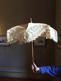
Accessory - Cream Silk & Lace Parasol, c.1900
Joseph Butterworth COOMBS (1842-1901), was an accountant who founded a successful mercantile trading company. At the time of his marriage to Caroline Mary MICHEL in 1869, Coombs had already purchased ten acres of Studley Park. The acreage included land on the west of Fenwick Street that extended along lower Stawell Street to the corner of Yarra Street, all of it connected directly to the Yarra environs. A right of way to Studley Park Road was on the title, though Coombs went on to purchase more land, some of which faced Studley Park Road. In addition to owning the Studley Park acreage, Coombs later acquired 1,201 acres of land abutting the Acheron River. While retaining the Kew property he became a Taggerty Councillor and was Shire President for a time. J.B. Coombs died at Acheron Station in 1901 (aged 59 years). A few months after, tenders were called to repair the Kew dwelling, the Fenwick Street property now appearing in records with the name ‘Hope Mansell’. Caroline Coombs remained at Hope Mansell until she died in 1924, survived by three sons and five daughters. Not long after her death, advertisements appeared for the sale of the Studley Park land. The sale seems to have been a mechanism for distribution of the Estate, as the following year the original ten acre holding was transferred to members of the family. The eldest daughter Mabel married William Younger who, with his brother Alexander, developed Younger and Mackie Courts, both south of Studley Park Road. [Research: Kerry Fairbank]In 1961, the granddaughter of Joseph and Caroline Coombs, Mabel Isola (Younger) Grattan, donated ten 19th century dresses and parasols to the Kew Historical Society. The costumes, now known as the 'Coombs Collection', are the earliest recorded items of clothing to enter the Society's collection. Each of the items in the Coombs Collection, of which this item forms a part, is historically, aesthetically and socially significant. As a collection, the costumes includes outstanding examples of morning wear, day dresses, wedding dresses, and clothing accessories, providing evidence of outstanding dressmaker skills in Victoria during the mid to late Victorian period. One of a pair of cream silk parasols, each bordered by overlapping bands of beige lace. The underlying structure and mechanism includes a bent cane handle and black metal expanding spokes. The lace borders are layered to create an overlapping fringe. The high-domed umbrellas may have been created for a bridal party."Coombs Collection"coombs collection, clothing accessories, parasols -
 Kew Historical Society Inc
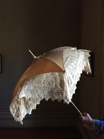
Accessory - Cream Silk & Lace Parasol, c. 1900
Joseph Butterworth COOMBS (1842-1901), was an accountant who founded a successful mercantile trading company. At the time of his marriage to Caroline Mary MICHEL in 1869, Coombs had already purchased ten acres of Studley Park. The acreage included land on the west of Fenwick Street that extended along lower Stawell Street to the corner of Yarra Street, all of it connected directly to the Yarra environs. A right of way to Studley Park Road was on the title, though Coombs went on to purchase more land, some of which faced Studley Park Road. In addition to owning the Studley Park acreage, Coombs later acquired 1,201 acres of land abutting the Acheron River. While retaining the Kew property he became a Taggerty Councillor and was Shire President for a time. J.B. Coombs died at Acheron Station in 1901 (aged 59 years). A few months after, tenders were called to repair the Kew dwelling, the Fenwick Street property now appearing in records with the name ‘Hope Mansell’. Caroline Coombs remained at Hope Mansell until she died in 1924, survived by three sons and five daughters. Not long after her death, advertisements appeared for the sale of the Studley Park land. The sale seems to have been a mechanism for distribution of the Estate, as the following year the original ten acre holding was transferred to members of the family. The eldest daughter Mabel married William Younger who, with his brother Alexander, developed Younger and Mackie Courts, both south of Studley Park Road. [Research: Kerry Fairbank]In 1961, the granddaughter of Joseph and Caroline Coombs, Mabel Isola (Younger) Grattan, donated ten 19th century dresses and parasols to the Kew Historical Society. The costumes, now known as the 'Coombs Collection', are the earliest recorded items of clothing to enter the Society's collection. Each of the items in the Coombs Collection, of which this item forms a part, is historically, aesthetically and socially significant. As a collection, the costumes includes outstanding examples of morning wear, day dresses, wedding dresses, and clothing accessories, providing evidence of outstanding dressmaker skills in Victoria during the mid to late Victorian period. One of a pair of cream silk parasols, each bordered by overlapping bands of beige lace. The underlying structure and mechanism includes a bent cane handle and black metal expanding spokes. The lace borders are layered to create an overlapping fringe. The high-domed umbrellas may have been created for a bridal party. This umbrella cannot be opened due to the silk being shattered."Coombs Collection"coombs collection, clothing accessories, parasols -
 Kew Historical Society Inc
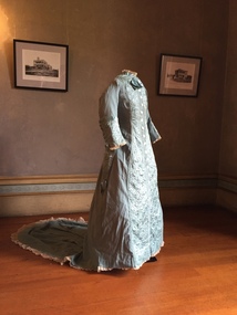
Clothing - Quilted Wool & Silk Afternoon Dress, c.1878
Joseph Butterworth COOMBS (1842-1901), was an accountant who founded a successful mercantile trading company. At the time of his marriage to Caroline Mary MICHEL in 1969, Coombs had already purchased 10 acres of Studley Park. The acreage included land on the west of Fenwick Street that extended along lower Stawell Street to the corner of Yarra Street, all of it connected directly to the Yarra environs. A right of way to Studley Park Road was on the title, though Coombs went on to purchase more land, some of which faced Studley Park Road. In addition to owning the Studley Park acreage, Coombs later acquired 1,201 acres of land abutting the Acheron River. While retaining the Kew property he became a Taggerty Councillor and was Shire President for a time. J.B. Coombs died at Acheron Station in 1901 (aged 59 years). A few months after, tenders were called to repair the Kew dwelling, the Fenwick Street property now appearing in records with the name ‘Hope Mansell’. Caroline Coombs remained at Hope Mansell until she died in 1924, survived by three sons and five daughters. Not long after her death, advertisements appeared for the sale of the Studley Park land. The sale seems to have been a mechanism for distribution of the Estate, as the following year the original 10 acre holding was transferred to members of the family. The eldest daughter Mabel married William Younger who, with his brother Alexander, developed Younger and Mackie Courts, both south of Studley Park Road. [Research: Kerry Fairbank]In 1961, the granddaughter of Joseph and Caroline Coombs, Mabel Isola (Younger) Grattan, donated ten 19th century dresses and parasols to the Kew Historical Society. The costumes, now known as the 'Coombs Collection', are the earliest recorded items of clothing to enter the Society's collection. Each of the items in the Coombs Collection, of which this item forms a part, is historically, aesthetically and socially significant. As a collection, the costumes includes outstanding examples of morning wear, day dresses, wedding dresses, and clothing accessories, providing evidence of outstanding dressmaker skills in Victoria during the mid to late Victorian period. Periwinkle blue afternoon dress made of finely woven wool with silk quilting to the yoke and cuffs. The one-piece outfit is fastened at front with large mother of pearl buttons. The dress includes a very long train. At one stage, the buttoning at the waist has been modified, presumably due to changes in the owner's waistline. women's clothing, australian fashion, costumes, dresses