Showing 285061 items
matching streets,roads,melbourne,map,melway
-
 Kew Historical Society Inc
Plan, Melbourne & Metropolitan Board of Works : Borough of Kew : Detail Plan No.1571, 1904
The Melbourne and Metropolitan Board of Works (MMBW) plans were produced from the 1890s to the 1950s. They were crucial to the design and development of Melbourne's sewerage and drainage system. The plans, at a scale of 40 feet to 1 inch (1:480), provide a detailed historical record of Melbourne streetscapes and environmental features. Each plan covers one or two street blocks (roughly six streets), showing details of buildings, including garden layouts and ownership boundaries, and features such as laneways, drains, bridges, parks, municipal boundaries and other prominent landmarks as they existed at the time each plan was produced. (Source: State Library of Victoria)This plan forms part of a large group of MMBW plans and maps that was donated to the Society by the Mr Poulter, City Engineer of the City of Kew in 1989. Within this collection, thirty-five hand-coloured plans, backed with linen, are of statewide significance as they include annotations that provide details of construction materials used in buildings in the first decade of the 20th century as well as additional information about land ownership and usage. The copies in the Public Record Office Victoria and the State Library of Victoria are monochrome versions which do not denote building materials so that the maps in this collection are invaluable and unique tools for researchers and heritage consultants. A number of the plans are not held in the collection of the State Library of Victoria so they have the additional attribute of rarity.Original survey plan, issued by the MMBW to a contractor with responsibility for constructing sewers in the area identified on the plan within the Borough of Kew. The plan was at some stage hand-coloured, possibly by the contractor, but more likely by officers working in the Engineering Department of the Borough and later Town, then City of Kew. The hand-coloured sections of buildings on the plan were used to denote masonry or brick constructions (pink), weatherboard constructions (yellow), and public buildings (grey). This plan is the other half of Plan No.1571 representing the constructions to the west of Wellington Street before and in 1903/4. This plan represents the built environment in Edgevale Road, Wellington Street, Atkins Street, Annadale Street, Mortimer Street, and Cotham Road. Whereas there are smaller allotments and more modest housing stock facing Edgevale Road, larger blocks and more substantial houses are represented facing Cotham Road.melbourne and metropolitan board of works, detail plans, mmbw 1571, cartography -
 Ballarat Tramway Museum
Map, Ministry of Transport, "Metropolitan Transport Services Map - Melbourne - Tram and Bus Services", c1970
Pocket size - folded - public transport map of Melbourne, printed in colours showing the bus, train and tram routes around Melbourne. Has a cover price of 10c. No printing date shown, but c1970 as distances are still in imperial, the West gate bridge is shown, though so is the Williamstown Ferry. Gives telephone numbers in 6 digit figures. Lists route numbers for trams, tramways board bus services and private services. Gives various telephone numbers for further information. Notes the map is a combined effort of the Tramways Board, Victorian Railways, Bus Proprietors' Association and the Transport Regulation Board. Single sheet of paper folded in 9 x 3 folds.trams, tramways, melbourne, map, public transport, routes -
 Melbourne Tram Museum
Poster, P. Sohns, "Melbourne Tram Track map (June 2006)", 2006
Poster - titled "Melbourne Tram Track map (June 2006)", line drawing on white paper, showing a detailed track map of junctions, depots, cross overs, route numbers, Preston Workshop, track out of service but overhead still in place, routes under construction of planning. Prepared by P. Sohns with Research by H. Waldron. Dated 8/4/2006. Has a detailed inserted of the city area. One unlaminated and one laminated copy held.trams, tramways, melbourne, map, tramways, depots, workshops, tram routes -
 Marysville & District Historical Society
Map (Item) - Tourist Map, Tourists Resorts' Committee, Tourist's Map of Healesville Marysville and Warburton Districts, 13.10.1925
A tourist map for Healesville, Marysville and Warburton that was produced by the Tourists Resorts' Committee. This map was produced in 1925.A tourist map for Healesville, Marysville and Warburton that was produced by the Tourists Resorts' Committee.Photo Lithographed at the Department of Lands and Survey, Melbourne by W.J. Butson./ 13.10.25healesville, marysville, warburton, victoria, tourists resorts' committee, ben cairn, mount donna buang, the black's spur, the acheron valley, narbethong, launching place, tourist information, tourism, map, tourist map -
 Port Melbourne Historical & Preservation Society
Map, Port Melbourne City Council, Port Melbourne - Our City, Our Life, Our Choice - No Amalgamation, Jun 1986
Port Melbourne - Our City, Our Life, Our Choice - No Amalgamation Proposal with City of Port Phillip map amalgamation, mayors, local government - city of port melbourne, local government - city of port phillip, liana thompson -
Whitehorse Historical Society Inc.
Map, Melbourne Geological Map, 1937
Geological Map of Melbourne & Suburbs.Geological Map of Melbourne & Suburbs. Scale: 40 chains to 1 inch with inset 10 miles to 1 inch. Includes Municipal and Parish boundaries, railways and stations, electric tramways, cable tramways, Post Offices and State schools. Area bounded by Braybrook, Preston, Blackburn & Brighton. Printed on linen.Geological Map of Melbourne & Suburbs. melbourne, maps -
 Melbourne Tram Museum
Document, Ministry of Transport, "Travel Smart Map - Port Phillip", 2010
Gives extensive details of walking cycling Public Transport in Port Phillip. Printed 2010. Yields information about Port Phillip transport and other services in 2010Map - pocket - 28 fold - showing walking, cycling and public transport in the City of Port Phillip, using a Melway Map base along with public transport information, Metcard, cycling and walking groups.tramways, melbourne, tram services, bus services, railways, port phillip, cyclists -
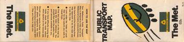
 Melbourne Tram Museum
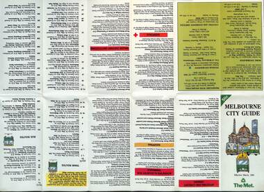
Map, The Met, "Melbourne City Guide", March 1991
Map issued by The Met, March 1991 based on a Melway map of the Central city area providing details of tram, bus and trains, attractions, major institutions, tourism information, and dining out areas or streets. Demonstrates a map produced by The Met to assist Melbourne visitors.Map - 14 fold printed on gloss paper.trams, tramways, the met, maps, melbourne, cbd -
 Melbourne Tram Museum
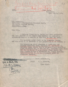
Document - Memorandum, Melbourne & Metropolitan Tramways Board (MMTB), "Parade of Boy Scouts and Cadets, Through City Streets, Friday 24 May 1946 - 1:30 to 2:20pm Approximately", 11/04/1946 12:00:00 AM
... "Parade of Boy Scouts and Cadets, Through City Streets ...Parade of Boy Scouts and Cadets, Through City Streets, Friday 24 May 1946 - 1:30 to 2:20pm Approximately Letter from HS Wooton, Melbourne Town Clerk to the Secretary MMTB advising of Empire Day Movement procession through the city on 24 May 1946. Letter dated 11 April 1946. Memo from Assistant Manger to Officers Concerned. Memorandum - several typed sheets (8"x10.5") - titled "Parade of Boy Scouts and Cadets, Through City Streets, Friday 24 May 1946 - 1:30 to 2:20pm Approximately" from JM Harry, District Traffic Superintendent S.S. to Mr Mazoletti, Malvern Depot, Mr McLean, Hanna Street Depot, and Mr Cliff, Glenhuntly Depot. Memo dated 21 May October and specifies tram shunting and special trams for the procession."Empire Day Movement Procession Fri 24/5/46" written in red pencil on the letter. Date, assembly point and procession route underlined in red pencil. "13 mts to pass ? & City Rds 1.30 to 1.43" initials and date written in black ink. "5 copies" and "23rd" "1947" written in black pencil on Malvern memo "4 copies" and "23rd" "1947" written in black pencil on Hanna Street memo "5 copies" and "23rd" "1947" written in black pencil on Glenhuntly memotrams, tramways, letters, instructions, events -
 Montmorency–Eltham RSL Sub Branch
Map - Framed Japanese Map of Darwin Circa 1942, WW2 Japanese Map of Darwin, Estimated date 1940-41
Returned to Australia, from America, where it had been brought back from Japan.Framed map of Darwin with Japanese overprint.'This map is a proof copy of a Japanese Reprint of an Australian map of Darwin.'darwin, world war two, japan, australia, 1942, 1941, maps -
 Hume City Civic Collection
Manual - Street Directory, Morgan's Official Street Directory of Melbourne and Suburbs, 1980's
This street directory of Melbourne and Suburbs was the 52nd edition published by Val Morgan. It is printed with a new map format.A Morgan's street directory of Melbourne and Suburbs without a front cover.morgan, val and co., melbourne, directories, street directories, george evans collection -
 Kew Historical Society Inc
Photograph, Corner of Cotham and Burke Roads, Kew, 1919
... Corner of Cotham and Burke Roads, Kew ...Black and white photograph of the corner of Cotham and Burke Roads in Kew. The house at centre is 'Deepdene'. Public and private transport is represented by the two horses pulling a carriage into Whitehorse Road and the tram at the terminus. The photograph is one of two of the vista gifted by the Bennett family in 1980.NEAR COTHAM ROAD CNR / HORSE TRANSPORT 1890s? / GIFT FROM BENNETT FAMILYburke road (kew, cotham road (kew), deepdene, trams -
 Ringwood and District Historical Society
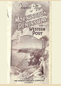
Memorabilia, Tourist Map of Mornington Peninsula and Western Port - 1929
Multi-fold pictorial map of towns, railways and main roads east of Port Phillip Bay from Melbourne to Yarra Junction and south to Phillip Island and Wonthaggi, backed by details of main features and points of interest.Photo-Lithographed by Department of Lands and Survey, Melbourne, 2.8.1929. -
Federation University Historical Collection
Map, Creswick Gold Field Map, 1981
A fragment of the original 1880 map is also held in the collection. See 116Rectangular geological map with brown paper strip on top edge with 4 holes on top edge. Scale is 40 chains to one inch.Geologically and topographically surveyed by Ferdinand M Krause. Lithographed by R. Shepherd. Printed by J. Finnie. Mining Department, Melbourne. Preprinted with additional shaft and lead detail. F. D. Atkinson, Government Printer 1981creswick, krause, surveyor, smeaton, spring hill, tourello, ascot, dean, bullarook, gold fields, gold -
University of Melbourne, Burnley Campus Archives
Map (item) - Geological map, Geological map of Melbourne & suburbs. Issued by the Department of Mines, Victoria, 1937
-
 Melbourne Tram Museum
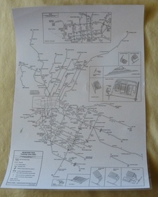
Map, The Met, "Public Transport Map - No. 13", 1984
Map No. 13 undated with the buzzing bee symbol on the front and throughout at the time of the introduction of the neighbourhoods. Includes description of tram and bus routes, private bus routes. Has contact details for bookings and lost property etc and how to use the map. Gives extensive details of the neighbourhood tickets and their used. C1984.Yields information about Melbourne public transport services in 1984.Fold out map (36 sections 9 across x 4 deep), "Public Transport Map", coloured of Melbourne's Tram and Bus routes, route numbers, rail lines, detailed for the central part of Melbourne and the outer Metropolitan services.tramways, melbourne, tram services, bus services, maps -
![Governing the Metropolis: politics, technology and social change in a Victorian city - Melbourne, 1850-1891 / [by] David Dunstan](/media/collectors/550653872162f11fb04854aa/items/5ed0413cdcf9cd08346b6448/item-media/5ed04231dcf9cd08346b66f5/item-fit-380x285.jpg) Kew Historical Society Inc
Kew Historical Society IncBook, Melbourne University Press, Governing the Metropolis: politics, technology and social change in a Victorian city - Melbourne, 1850-1891, 1984
Carlton, Vic. : Melbourne University Press, 1984 xvii, 362 p., [14] p. of plates : ill., facsims., maps, ports. ; 24 cm. non-fictionmelbourne metropolitan area (vic) -- politics and government -- 1851-1891., urbanization -- victoria -- melbourne. -
Port Melbourne Historical & Preservation Society
Map, Port Melbourne Sheet 4, 1962
Framed line drawn map of Port Melbourne (sheet 4) 1962, covering the area from Beach Street (including Station and Princes Piers) to Plummer Street and Todd Road area to Dow Streetbuilt environment -
 Kew Historical Society Inc
Plan, Melbourne & Metropolitan Board of Works : Borough of Kew : Detail Plan No.1571, 1904
The Melbourne and Metropolitan Board of Works (MMBW) plans were produced from the 1890s to the 1950s. They were crucial to the design and development of Melbourne's sewerage and drainage system. The plans, at a scale of 40 feet to 1 inch (1:480), provide a detailed historical record of Melbourne streetscapes and environmental features. Each plan covers one or two street blocks (roughly six streets), showing details of buildings, including garden layouts and ownership boundaries, and features such as laneways, drains, bridges, parks, municipal boundaries and other prominent landmarks as they existed at the time each plan was produced. (Source: State Library of Victoria)This plan forms part of a large group of MMBW plans and maps that was donated to the Society by the Mr Poulter, City Engineer of the City of Kew in 1989. Within this collection, thirty-five hand-coloured plans, backed with linen, are of statewide significance as they include annotations that provide details of construction materials used in buildings in the first decade of the 20th century as well as additional information about land ownership and usage. The copies in the Public Record Office Victoria and the State Library of Victoria are monochrome versions which do not denote building materials so that the maps in this collection are invaluable and unique tools for researchers and heritage consultants. A number of the plans are not held in the collection of the State Library of Victoria so they have the additional attribute of rarity.Digital copy of the original survey plan, issued by the MMBW to a contractor with responsibility for constructing sewers in the area identified on the plan within the Borough of Kew. The plan was at some stage hand-coloured, possibly by the contractor, but more likely by officers working in the Engineering Department of the Borough and later Town, then City of Kew. The hand-coloured sections of buildings on the plan were used to denote masonry or brick constructions (pink), weatherboard constructions (yellow), and public buildings (grey). This plan is part of a large and historically significant group of MMBW plans and maps that was donated to the Society by the Mr Poulter, City Engineer of the City of Kew in 1989. When the contracts were let for surveyors to identify and record the extant houses and landscapes within an area for the Board of Works, the contracts were let at separate times, hence the anomaly where two copies of Plan No.1571 exist in our collection. The first of these plans identifies the building materials used in houses bordering Fitzwilliam Street, Edgevale Road, May Street, Malin Street, Davis Street and Wellington Street. The cut off point for the survey was the south side of Wellington Street. By 1903 when the survey was undertaken many of the sites were already built on, particularly those facing Edgevale Road. The plan identifies the preponderance of weatherboard houses in the area. The other version of the plan identifies the buildings between Wellington Street and Cotham Road.melbourne and metropolitan board of works, detail plans, mmbw 1571, cartography -
Ringwood and District Historical Society
Map, Government Printer, Melbourne, Ringwood Zone Ordinance Survey Map, 1935
Ordinance survey map glued to cheesecloth, of Ringwood zone - Commonwealth topographical map dated 1.8.35, scale 1:63,360. Information correct up to June 1922. "Ringwood 81" printed on the reverse side.; Envelope and note from donor of item, with return letter of appreciation from Ringwood & District Historical Society dated 20-May-2005. +Additional Keywords: Reid, Don -
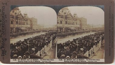 Linton and District Historical Society Inc
Stereograph, The Rose Stereographs, Melbourne, Sydney, Wellington and London, 12,888 The American Fleet in Australia, United States Sailors Marching Through the City of Melbourne, Copyright 1908
One of two sets of stereographs donated by the O'Beirne family along with a stereoscope for viewing (Stereoscope is Registration no. 2014-51).Crowd of people standing along Spring Street, Melbourne watching a large group of sailors marching by. Princes Theatre in background."12,888. THE AMERICAN FLEET IN AUSTRALIA. The United States Sailors/Marching through the City of Melbournestereographs, american fleet -
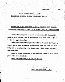 Melbourne Tram Museum
Document - Memorandum, Melbourne & Metropolitan Tramways Board (MMTB), Procession of 7th Division AIF through city streets, Wednesday 19 April 1944, 16/02/1944 12:00:00 AM
... Procession of 7th Division AIF through city streets ...Procession of 7th Division AIF through city streets, Wednesday 19 April 1944 4 memos from JM Harry, Dist Traffic Supt, to depots for tram arrangements for above event. Letter from HS Wootton, Town Clerk, City of Melbourne, outlining parade arrangements.Pencil comments to Mr Harry to notetrams, tramways, events, parades, world war 2 -
Port Melbourne Historical & Preservation Society
Book, Universal Business Directories (Aust) Pty Ltd, Universal DeLuxe Streets Directory, 1959
... Universal DeLuxe Streets Directory ...1959 Streets Directory for Melbourne City and Suburbs including large scale maps, hospitals, schools, police stations, town halls, telephone booths, tram stops, railways. Fifth edition. Red and Buff cardboard cover, red binding.transport - roads, street directory -
Port Melbourne Historical & Preservation Society
Map, Fredrick C COOK C.E.L.S, City of Port Melbourne, Nov 1938
1/600 map of the City of Port Melbourne by City Engineer, Fredrick C COOK.Map of Port Melbourne, November 1938local government - city of port melbourne, fredrick c cook -
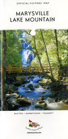 Marysville & District Historical Society
Map (Item) - Tourist map, Mystic Mountains Tourism, OFFICIAL VISITORS' MAP MARYSVILLE LAKE MOUNTAIN, Unknown
A visitors' map of Marysville and Lake Mountain produced by Mystic Mountains Tourism for Visit Victoria.A visitors' map of Marysville and Lake Mountain produced by Mystic Mountains Tourism for Visit Victoria.The Marysville and Lake Mountain Visitor Map and Touring Guide has been compiled and/ published by Mystic Mountains Tourism Inc. Copyright./ Production and artwork Graph Attack P/Lmarysville, lake mountain, victoria, australia, visitor's map, official visitors' map marysville lake mountain, buxton, narbethong, taggerty, visit victoria, mystic mountains tourism inc, graph attack p/l, mystic mountains, marysville triangle, marysville visitor information centre, marylands country house, black spur, steavenson falls, lady talbot drive, cambarville, cathedral ranges, wirreanda festival, lake mountain summit walk, summit walk loop, leadbeaters loop, day loop walk, buxton hotel, igloo roadhouse, karmann waters, silverstream b&b cottages, buxton trout and salmon farm, the niche wine bar, buxton post office & general store, choppers buxton roadhouse, woodlands rainforest bungalows, chestnut glade, black spur inn, wombat cottage, abbey lake luxury b&b spa cottages, mystic mountain ski hire & outdoors, pnl 4wdriving, blue views holiday units & ski hire, marapana agistment park & farm stay b&b, danico design, things of sand & stone, mantirri blueberry farm, allawah country cottages, amberview cottages, ashlar cottage b&b, black spur motel & caravan park, blackwood deluxe cottages, blackwood courtyard b&b, dalrymples guest cottages, delderfield, el kanah guest house, fruit salad farm, kerami guest house, keppels hotel, lake mountain-snow gum lodge, lomatia lodge, lyell guest cottages, magnolia house, keppel waters, lyrebird apartments, marysville caravan park, all view spa apartments, riverside cottages, maryton park b&b country cottages, melina cottage, mountain lodge, mystic mountains holiday cottages, nanda binya lodge, rendezvous luxury cottages, scenic b&b motel, the cumberland, south cathedral farm, tower motel, willowbank at taggerty, woodlands rainforest retreat, marysville & district country club inc, mystic mountains ski hire & outdoors, rubicon valley horse riding, marysville trout and salmon ponds, gallipoli park, keppels lookout, cambarville-yarra ranges national park, lake mountain-yarra ranges national park, lady talbot drive-yarra ranges national park, cathedral range state park, steavenson river, taggerty river, acheron river, lake mountain alpine resort, bruno's art and sculpture garden, manical mechanicals, uncle fred & aunty val's old style lolly shop, carmyle farm boutique, crossways historic country inn, fraga's, gilberts restaurant, heights licensed bistro, the old woolshed cafe, cathedral view natural therapies, crystal journey -
 Kew Historical Society Inc
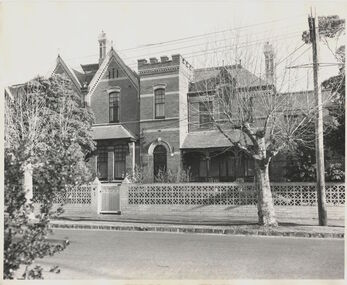
Photograph, House, cnr Fellows & Princess Streets, circa 1965, c. 1965
... House, cnr Fellows & Princess Streets, circa 1965 ...17 Fellows Street Kew was originally owned and occupied by the architect Henry Kemp. Kemp had arrived in Australia in 1886 and this was therefore one of the first of the many buildings he was to design in Melbourne. While late Victorian in date, the house is an interesting precursor of the Edwardian architecture produced by Kemp. Somewhat awkwardly composed with steep gables, a rectangular castellated tower and slated single storeyed verandahs projecting from the overall box-like form, the house contains features common to the 1880s such as the use of polychromy in the brickwork and slates cladding the roof. (Sanderson 1988). The historian Dorothy Rogers established that at one stage it was the home of Dr John Dale - Chief Medical Officer of the City of Melbourne. This photograph predates later renovations to the rear of the property.This work forms part of the collection assembled by the historian Dorothy Rogers, that was donated to the Kew Historical Society by her son John Rogers in 2015. The manuscripts, photographs, maps, and documents were sourced by her from both family and local collections or produced as references for her print publications. Many were directly used by Rogers in writing ‘Lovely Old Homes of Kew’ (1961) and 'A History of Kew' (1973), or the numerous articles on local history that she produced for suburban newspapers. Most of the photographs in the collection include detailed annotations in her hand. The Rogers Collection provides a comprehensive insight into the working habits of a historian in the 1960s and 1970s. Together it forms the largest privately-donated collection within the archives of the Kew Historical Society17 Fellows Street, Fellows Street frontage."17 Fellows St. Also residence of Dr. John Dale, Melbourne City Medical Officer"fellows street (kew), dorothy rogers, henry kemp, dr john dale -
 Kew Historical Society Inc
Plan, Melbourne & Metropolitan Board of Works : Borough of Kew : Detail Plan No.1572, 1905
The Melbourne and Metropolitan Board of Works (MMBW) plans were produced from the 1890s to the 1950s. They were crucial to the design and development of Melbourne's sewerage and drainage system. The plans, at a scale of 40 feet to 1 inch (1:480), provide a detailed historical record of Melbourne streetscapes and environmental features. Each plan covers one or two street blocks (roughly six streets), showing details of buildings, including garden layouts and ownership boundaries, and features such as laneways, drains, bridges, parks, municipal boundaries and other prominent landmarks as they existed at the time each plan was produced. (Source: State Library of Victoria)This plan forms part of a large group of MMBW plans and maps that was donated to the Society by the Mr Poulter, City Engineer of the City of Kew in 1989. Within this collection, thirty-five hand-coloured plans, backed with linen, are of statewide significance as they include annotations that provide details of construction materials used in buildings in the first decade of the 20th century as well as additional information about land ownership and usage. The copies in the Public Record Office Victoria and the State Library of Victoria are monochrome versions which do not denote building materials so that the maps in this collection are invaluable and unique tools for researchers and heritage consultants. A number of the plans are not held in the collection of the State Library of Victoria so they have the additional attribute of rarity.Original survey plan, issued by the MMBW to a contractor with responsibility for constructing sewers in the area identified on the plan within the Borough of Kew. The plan was at some stage hand-coloured, possibly by the contractor, but more likely by officers working in the Engineering Department of the Borough and later Town, then City of Kew. The hand-coloured sections of buildings on the plan were used to denote masonry or brick constructions (pink), weatherboard constructions (yellow), and public buildings (grey). Plan No. 1572 represents the built environment bordered by Barkers Road, Wrixon Street, Edgevale Road and Fitzwilliam Street. Other streets identified on the plan include Stansell Street. Plan 1572 shows that by 1903-05, there was only patchy development in this area of Kew, mainly on Edgevale Road and Fitzwilliam Street. Only two named houses are identified: the quaintly named ‘Tweed Cottage’, and ‘Mendip’. The earliest reference to Treed Cottage in Australian newspapers is to the death of Walter Thompson, aged 74 who was a resident there in 1885. His youngest daughter was to die there in 1908. Mendip to the north of Tweed Cottage was owned by Henry Thompson; he was to die in 1901; his wife in 1932. At this period of time, Malin Street and Clivedon Court did not extend to Barkers Road.melbourne and metropolitan board of works, detail plans, mmbw 1572, cartography -
 Kew Historical Society Inc
Plan, Melbourne & Metropolitan Board of Works : Borough of Kew : Detail Plan No.1590, 1905
The Melbourne and Metropolitan Board of Works (MMBW) plans were produced from the 1890s to the 1950s. They were crucial to the design and development of Melbourne's sewerage and drainage system. The plans, at a scale of 40 feet to 1 inch (1:480), provide a detailed historical record of Melbourne streetscapes and environmental features. Each plan covers one or two street blocks (roughly six streets), showing details of buildings, including garden layouts and ownership boundaries, and features such as laneways, drains, bridges, parks, municipal boundaries and other prominent landmarks as they existed at the time each plan was produced. (Source: State Library of Victoria)This plan forms part of a large group of MMBW plans and maps that was donated to the Society by the Mr Poulter, City Engineer of the City of Kew in 1989. Within this collection, thirty-five hand-coloured plans, backed with linen, are of statewide significance as they include annotations that provide details of construction materials used in buildings in the first decade of the 20th century as well as additional information about land ownership and usage. The copies in the Public Record Office Victoria and the State Library of Victoria are monochrome versions which do not denote building materials so that the maps in this collection are invaluable and unique tools for researchers and heritage consultants. A number of the plans are not held in the collection of the State Library of Victoria so they have the additional attribute of rarity.Original survey plan, issued by the MMBW to a contractor with responsibility for constructing sewers in the area identified on the plan within the Borough of Kew. The plan was at some stage hand-coloured, possibly by the contractor, but more likely by officers working in the Engineering Department of the Borough and later Town, then City of Kew. The hand-coloured sections of buildings on the plan were used to denote masonry or brick constructions (pink), weatherboard constructions (yellow), and public buildings (grey). Surveyed by the Board of Works in 1903 and published in 1904, Plan No.1590 shows development north of Cotham Road. While this plan includes built structures in Mary Street, Cotham Road, High Street, Park Hill Road, Kent Street, Ridgeway Avenue, and Ermington Lane (now Ermington Place), only part of this section was notated and coloured in this contractor’s copy. Numerous houses, large and small are named on the plan: ‘Cholula’, ‘Belper’, ‘The Uplands’, ‘Spring Grove’ facing Cotham Road; ‘Marion’ facing Kent Street; and ‘Kia Ora’ facing Ridgeway Avenue.melbourne and metropolitan board of works, detail plans, mmbw 1590, survey plans - borough of kew, cartography