Showing 167 items
matching survey equipment
-
 Glenelg Shire Council Cultural Collection
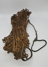
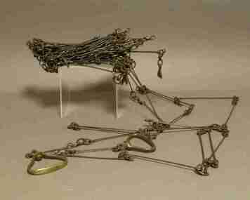
Equipment - Surveyors chain, unknown
Before metric measurement was introduced land was measured by a tool of chains and links called a surveyor's chain. The first surveyor's chain was designed by the English clergyman and mathematician Edmund Gunter (1581-1626) and introduced in 1620. It comprised of a metal chain made up of 100 links measuring a precise overall length of 66 ft or 22 yards, with each link measuring 7.92 inches (201.168 mm). The Gunter's chain was originally intended to be used in the accurate laying out and measurement of plots of land, for legal and commercial purposes, but was subsequently widely used by surveyors throughout the British Empire and Europe, with an Imperial mile being 80 times the Gunter's chain length. A tool used to survey the land before the introduction of the metric system.Surveyor chain Gunter type, 100 links measuring 66 feet in length. Hand grips at each end of chain. Wire links are approximately eight inches long. Incised tags or markers are attached to each tenth link of chain to assist with the more accurate recording of intermediate distances.surveying tool -
 Department of Energy, Environment and Climate Action
Equipment - 'Acorn' Mathematical Set
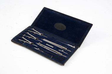
This and other sets advertised on 30 January 1937 by MULLENS stationers in Melbourne (Trove) Given to or acquired by Forester James McKinty. Probably in late 1937. Used for map making and draftingStainless steel drawing tools in felt-lined wooden boxembossed on the fabric on the inside of the lid of the box: ACORN MATHEMATICAL SET ROBERTSON & MULLENS Ltd MELBOURNEforests commission victoria (fcv), mapping, surveying -
 University of Melbourne, Burnley Campus Archives
Instrument - Optical Dumpy Level, Troughton & Simms, Dumpy Level, Pre 1915
... Found in the Curator's Cottage surveying equipment students ...Found in the Curator's CottageBrass Troughton & Simms, London optical dumpy level on compass base. Made for Kilpatrick & Co, Melbourne. See B91.126 for photograph of student using it Circa1968.Troughton & Sims LONDON Kilpatrick & Co Melbourne No. 702surveying equipment, students, landscaping -
 University of Melbourne, Burnley Campus Archives
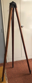
Accessory - Tripod, Timber Tripod, Pre 1960's
... before donation surveying equipment students landscaping dumpy ...Found in the Curator's Cottage, renovated by Robert James before donationLarge timber tripod with means of attachment for dumpy level (but not B24.0049). See B91.126 for photograph of tripod in use by a student.surveying equipment, students, landscaping, dumpy level -
 Bendigo Military Museum
Equipment - MAP CASE, Unknown
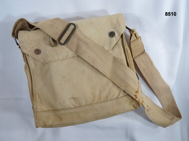
Khaki carry bag carried over the shoulder, possibly used as a mapping carry case or survey bag. The top flap is secured by press stud closures, the bottom of the bag has small brass ventilators. The bag is fitted with an over the shoulder carry strap.passchendaele barracks trust, equipment, bag, map case -
 Bendigo Military Museum
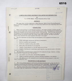
Administrative record - Royal Australian Survey Corps - A simple silk screen equipment for limited map reproduction by LTCOL HM Hall (RASvy) 1967, LtCol HM Hall (RASvy), 6 Feb 1967
This paper deals with the employment of Hand operated Mobile Screen Printing Equipment and its associated cartographic techniques for limited map reproduction and overprinting under field conditions. Written by LtCol HM Hall (RASvy)8 x A4 page document containing typed text, photos and map extractroyal australian survey corps, rasvy, fortuna, army survey regiment, army svy regt, asr, school of military survey, sms -
 Bendigo Military Museum
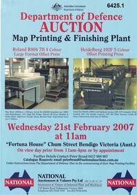
Flyer - Department of Defence Auction Flyer- Map Printing and Finishing Plant 21 Feb 2007, Department of Defence Auction Flyer - Map Printing and Finishing Plant 21 Feb 2007, 21 Feb 2007
This Flyer was produced by the Australian Govt Department of Defence for an auction to be held at Fortuna Bendigo on Wed 21 February 2007 at 11am for the sale of Map Printing and finishing Equipment that had been used by the Royal Australian Survey Corps at the Army Survey Regiment. The Flyer lists 76 x items of equipment being Auctioned. Items Auctioned include: Amrap Pallet Stretch Wrapping Machine, Crown 20IMT90 Electric Lift Truck, Roland R804 7B Large Format 4 x Colour Offset Printing Press, Wohlenburg 1850mm programmable Paper Guillotine Model MCS-2, Bauman Stack Lift, Barco Graphics Mega Setta Plus Large Format Image Setter, HP Design Jet 300P Colour Plotter and Heidelburg Speedmaster Model 102F 5 x Colour Offset Printing Press.A4 Auction Flyer, Blue, Double sided and 7 x photos of lithographic equipment. Contains lists of items to be auctioned.royal australian survey corps, rasvy, fortuna, army survey regiment, army svy regt, asr -
 Bendigo Historical Society Inc.
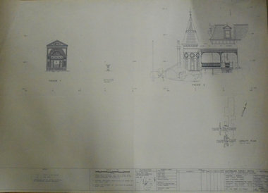
Plan - FORTUNA COLLECTION: FORTUNA VILLA
Originally built by Christopher Ballestedt (1796-1869) and his son Theodore. The Ballestedt's pioneered open cut and quartz mining on the Bendigo gold field. They were very successful. After Christopher's death, Theodore continued until 1871 when he sold Fortuna, their mines and equipment to George Lansell for 30,000 pounds.Four large plans of Fortuna villa. Scale 1:50 Australian survey office - Victoria Department of Administrative services. Fortuna Bendigo - Army Survey Regiment. Dept. of Defence - Army. Terrestrial Photogrammetric Survey. Project number: 8001/2. Reg. File: 64/531. Survey File:631. Draftsman: M.A. Osciak. Surveyed by G. Tucker. Date of Survey: 14/05/79. There are 4 large such plans in a plastic bag the measurement of the plans is approx. 115cm X 80 cm.plan, bendigo, fortuna villa -
 National Vietnam Veterans Museum (NVVM)
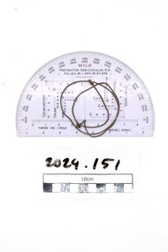
Equipment - Protractor
Standard issue item as used by Australian servicemen during the conflict in Vietnam (1962-1972). This object was issued to National Serviceman Private Bowd, Raymond Maxwell, who served in 3RAR in 1971.Semi circular plastic calculation protractor with olive green cord attachedProtractor Semi Circular RA / Mils, 6in, mls, Mk1, 6675.66, 011, 6100. Melb>W&Gsurvey, plastic, bowd, raymond bowd, 3rar -
 Bendigo Military Museum
Photograph - AUTOMAP 1 Production – Army Survey Regiment, Fortuna, Bendigo, c1978-1980
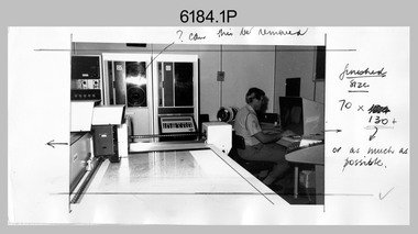
... This is a set of 20 photographs of Air Survey Squadron... operating AUTOMAP 1 equipment at the Army Survey Regiment at Fortuna ...This collection of 20 photos was most likely taken in c1978. The AUTOMAP 1 computer assisted cartography and mapping system was introduced in 1975. The components of AUTOMAP 1 were the Input Sub-System of four Wild B8s stereoplotters and three Gradicon digitising tables, the Optical Line Following Sub-System – Gerber OLF, the Verification Sub-System – Gerber 1442 drum plotter, the General Purpose Sub-system – HP21MX computer and the Output Sub-System – Gerber 1232 flatbed plotter). The first map was published in 1978 (Strickland 3665-3, 1:50,000). AUTOMAP 1 was the first computer assisted cartography and mapping system utilised by the Survey Corps and was the first system used by Australian mapping organisations. The history of the AUTOMAP 1 system is covered in more detail with additional historic photographs, in pages 116-118 of Valerie Lovejoy’s book 'Mapmakers of Fortuna – A history of the Army Survey Regiment’ ISBN: 0-646-42120-4. See items 6122.20P, 6410.24P, 6183.19P, 6200.5P, and 6222.17P for additional photographs of the AUTOMAP 1 system.This is a set of 20 photographs of Air Survey Squadron military and civilian personnel operating AUTOMAP 1 equipment at the Army Survey Regiment at Fortuna, Bendigo, c1978-1980. Black and white photos .1P to .18P are on photographic paper and were scanned at 300 dpi. Photo .4P is in colour and mounted with a duplicate on manilla card. Black and white photos .19P to .20P are on 35mm negative film and scanned at 96 dpi.They are part of the Army Survey Regiment’s Collection. .1) - Photo, black & white, c1978-1980, Gerber Optical Line Follower (OLF), SSGT John Bennett. .2) - Photo, black & white, c1978-1980, HP21MX computer General Purpose Sub-system. .3) - Photo, black & white, c1978-1980, Gerber OLF .4) - Photo, colour, c1978-1980, unidentified digitising on Gradicon edit table. .5) - Photo, black & white, c1978-1980, Gerber verification drum plotter. .6) - Photo, black & white, c1978-1980, Gerber OLF, CAPT Rob Bridge. .7) - Photo, black & white, c1978-1980, Programming and system administration, SGT Alan Toogood. .8) - Photo, black & white, c1978-1980, Unidentified digitising on Gradicon edit table. .9) - Photo, black & white, c1978-1980, CPL Rick Downie digitising on Gradicon edit table. .10) - Photo, black & white, c1978-1980, SPR Dave Irving digitising on Gradicon edit table. .11) - Photo, black & white, c1978-1980, Gerber OLF and CPL Rick Downie. .12) - Photo, black & white, c1978-1980, 1130 Computer System administration, L to R: unidentified, SSGT Les Dixon, SPR Geoff Havelberg. .13) - Photo, black & white, c1978-1980, AUTOMAP 1 tape administration, Maryanne De Groot. .14) - Photo, black & white, c1978-1980, AUTOMAP 1 tape drive. .15) - Photo, black & white, c1978-1980, HP21MX computer General Purpose Sub-system. .16) - Photo, black & white, c1978-1980, digitising topographic features with a Wild B8 stereo plotter, L to R: unidentified, CPL John Smith. .17) - Photo, black & white, c1978-1980, digitising topographic features with a Wild B8 stereo plotter, CPL John Smith. .18) - Photo, black & white, c1978-1980, digitising topographic features with a Wild B8 stereo plotter, CPL Adrian Rynberk. .19) - Photo, black & white, c1978-1980, Programming and system administration, SGT Alan Toogood. .20) - Photo, black & white, c1978-1980, Gerber OLF, CPL Chris Edwards. .1P to .20P - No personnel are identified.royal australian survey corps, rasvy, army survey regiment, army svy regt, fortuna, asr, automap 1 -
 Bendigo Military Museum
Photograph - 4th Field Survey Squadron – Operation MIZMAZE 92, Kimberley region, Western Australia, 1992
This is a set of 40 photographs taken in 1992 during 4th Field Survey Squadron’s deployment on Operation MIZMAZE 92 in the Kimberley region of Western Australia from the 13th of May to the 14th of July 1992. The area of operations was Wyndham, Halls Creek and Sandfire Flat. It was a two-part operation involving the field completion of topographic maps and the acquisition of mapping control by GPS field parties utilising Texas Instruments TI4100 Global Positioning System receivers. Survey parties conducted field checking of topographic maps and GPS control acquisition in Perentie 110 Series Survey variant FFR Land Rovers. Three Bell Kiowa LOH helicopters provided by 162 Recce Sqn supported field checking and limited deployment of GPS surveys parties. C-l30 Hercules from 36 Sqn supported deployment and extraction of personnel and equipment to and from from the AO. A Cessna 404 Titan Ambassador from Vee-H Aviation was used as the Wild RC10 camera platform for aerial photography acquisition.This is a set of 40 photographs taken in 1992 during 4th Field Survey Squadron’s deployment on Operation MIZMAZE 92 in the Kimberley region of Western Australia. The colour photographs are on 35mm negative film and are part of the Army Survey Regiment’s Collection. The photographs were scanned at 96 dpi. .1) - Photo, colour, 1992. CAPT Craig Hersant. .2) - Photo, colour, 1992. Unidentified officer/soldier. .3) & .4) - Photo, colour, 1992. Aboriginal rock art - Wandjina Gunduran, Donkey Creek. .5) - Photo, colour, 1992. Aboriginal rock art - Track Wandjinas, Donkey Creek. .6) & .7) - Photo, colour, 1992. CAPT Craig Hersant. .8) - Photo, colour, 1992. Kimberley region topography. CPL Glen Weatherell. .9) - Photo, colour, 1992. Unidentified personnel .10) - Photo, colour, 1992. Supermarket at unknown location. .11) to .13) - Photo, colour, 1992. Caravan park at unknown location. .14) - Photo, colour, 1992. Old bridge at Fitzroy Crosssing. .15) & .16) - Photo, colour, 1992. Survey party in Perentie 110 Series Land Rover. .17) & .18) - Photo, colour, 1992. Kimberley region topography. .19) - Photo, colour, 1992. Kimberley region topography. CPL Glen Weatherell. .20) - Photo, colour, 1992. Kimberley region topography, possibly the Bungle Bungles. .21) - Photo, colour, 1992. Kimberley region topography. SGT Frank Downie. .22) - Photo, colour, 1992. Kimberley region topography: the Bungle Bungles. .23) - Photo, colour, 1992. Kimberley region topography: the Bungle Bungles. .24) - Photo, colour, 1992. Kimberley region topography: the Bungle Bungles. SPR Neil Pedler. .25) & .26) - Photo, colour, 1992. Kimberley region topography: the Bungle Bungles. .27) - Photo, colour, 1992. Kimberley region topography. .28) - Photo, colour, 1992. Survey party with Perentie 110 Series Land Rover. .29) - Photo, colour, 1992. Kimberley region topography. .30) - Photo, colour, 1992. Survey party outside Perentie 110 Series Land Rover. .31) & .32) - Photo, colour, 1992. Survey party operating TI4100 GPS Receiver next to Perentie 110 Series Land Rover. SGT Eddie Jacobs. .33) & .34) - Photo, colour, 1992. Survey party operating TI4100 GPS Receiver next to Perentie 110 Series Land Rover. Unidentified surveyor. .35) - Photo, colour, 1992. Kimberley region topography. Hand water pump at well. .36) - Photo, colour, 1992. Survey party in Perentie 110 Series Land Rover. .37) - Photo, colour, 1992. Kimberley region topography. CPL Glen Weatherell. .38) - Photo, colour, 1992. Kimberley region topography viewed from Bell Kiowa LOH helicopter. .39) & .40) - Photo, colour, 1992. Unidentified surveyor field checking a preliminary map in a Bell Kiowa LOH helicopter..1P to .40P – There are no personnel identified. ‘1992 OP MIZMAZE annotated on negative sleeve.royal australian survey corps, rasvy, 4 fd svy sqn, op mizmaze 92 -
 Geoffrey Kaye Museum of Anaesthetic History
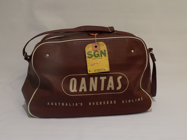
Container - Qantas bag
Dr James (Jim) Villiers went to Vietnam as an anaesthetist with the Australian Surgical Team (civilian) during 1963. He used this bag for carry-on luggage. Despite assurances about the quality of resources available on arrival, he carried an essential part of the breathing circuit for an EMO vaporiser in his carry-on. The actual vaporiser was packed in his check-in luggage. In 1963 the Vietnamese government sought training in Australia in anaesthetics for several medical technicians. Australia was not able to meet the request as anaesthesia training in Australia is restricted to qualified doctors. Instead, the Dean of the Faculty of Anaesthetists at RACS suggested sending a team of anaesthetists to Vietnam to conduct training for technicians there. However, they requested a preliminary survey be undertaken in order to determine the abilities of the prospective trainees and establish contacts with medical authorities in Vietnam. James (Jim) Villiers was one of the people who undertook the survey and made a report. Training of Vietnamese medical technicians was undertaken using the Epstein MacIntosh Oxford Anaesthetic Apparatus (EMO). This equipment was robust, portable and relatively cheap, there are few moving parts for servicing, it requires only ether and air for operation.Brick-red vinyl bag with white Qantas branding including the flying kangaroo printed on both sides. The bag has a zipper opening and contains an anaesthetic apparatus mounted on a piece of wooden particle board. There are two black hoses, a white hose, a black plastic connector, a metal t-bar connect, a green resuscitation bag and black face mask.james villiers, malignant hyperthermia, vietnam, qantas, australian surgical team, long xuyen, bien hoa, anaesthesia training -
 Bendigo Military Museum
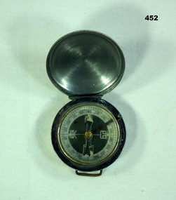
Equipment - COMPASS JAPANESE, C. 1939 - 45
... . Refer 2054.2 for his service history. surveying-terrestrial ...Item souvenired by Leslie John Kupke No VX93892 2nd AIF. Refer 2054.2 for his service history. Japanese compass with hinged cover. Casing made of metal. N,S,E,W in Japanese. Case has loops for attaching to a strap.PATEN 2908 stamped on back (worn but visible)surveying-terrestrial, military - equipment, japan -
 National Vietnam Veterans Museum (NVVM)
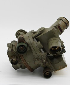
Equipment - Dumpy level in case
Standard equipment as used by Australian servicemen during the Vietnam conflict. This type of level was first issued for use in WW2.Khaki metal instrument with lens-viewfinder and numbers on circular range finding wheels. Object is stored in a khaki metal box with canvas carry straps. Attachments inside the box prevent it from slipping. Red label attached to strap says the object cannot be repaired.place/date/McBc = GdBg/ McB6 = GdBg/ BuBl COR. Inside box: scientific instruments MFGI and Repair Co. Pty Ltd/ 573 Burwood Road, Hawthorn 815527surveying tool, dumpy level, survey, surveyor, level -
 Ballarat Tramway Museum
Administrative record, State Electricity Commission of Victoria (SECV), "Some notes pertaining to tramway conference, Ballarat", 4/1954
Set of notes prepared before the 1954 conference by the Ballarat office. Notes actions on the 1952 and 1953 conferences, rail profile survey, bitumen paving, painting of tram, blinds, removal of sun blinds, lights fitted to trams, brake blocks - hardness and allowable wear, side bearing clearances, castings, track and depot workshop hours, costs, trolley wheels, lubrication products used, alterations to Maximum traction tramcars, and failure of pony wheel axles.Yields information and demonstrates SECV meeting notes prepared prior to a joint meeting.Four foolscap sheets - carbon copy.secv, ballarat, trams, tramways, minutes, sec, tramcar equipment, maintenance, trackwork, trolley wheels, motors, maximum traction, employees -
 Federation University Historical Collection
Instrument - Survey Chain, Chesterman, Gunter's Survey Chain
Before metric measurement was introduced land was measured in chains and links. The chain was a precision part of a surveyor's equipment. It required frequent calibration, yet needed to be sturdy enough to be dragged through rough terrain for years. A standard survey chain is 66 feet (or 20.117m) long and made up of 100 links. Each link is 7.92 inches (approximately 201mm) long, measured from the inside of the loop. The handles are for tensioning the chain in use, they are not part of the length of the chain. In pre-metric units, there were 80 chains to 1 mile (equals 1.609km) This surveyor’s chain has an 8-inch link pitch, with markers at 10 link intervals. This metal surveyor’s chain (or Gunter's Chain) has an 8-inch link pitch, with markers at 10 link intervals, and handles at either end. A Surveyor’s Chain was 66 feet long, and made up of 100 links connected by two rings. A link in measurement includes the two rings at each end. gunter's chain, survey chain, surveyor s chain, perch, rood, surveying -
 Bendigo Military Museum
Headwear - BERET & BADGE, 1960’s
Beret and badge issued to Geoffery Charles Murray No 3411521, Vietnam 3 Cav Regt 27.11.67 to 22.10.68, Survey Corp 15.10.69 to 15.10.70.Black Woolen Beret with a Silver Armoured Corp Badge“Kent pure wool large”military-equipment, beret, armoured corp