Showing 223 items
matching tall trees
-
 The Beechworth Burke Museum
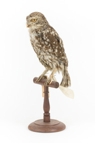
Animal specimen - Diurnal Owl / Ural Owl
Little owls (also known as the owl of Athena or owl of Minerva) usually prefer the warmer parts of Europe, North Africa and Asia, enjoying open country and agricultural land with high trees to swoop down upon their prey from. Their diet includes amphibians, small mammals, reptiles and insects that they also hunt from small holes in the ground. Little owls are monogamous and while they're usually solitary creatures, pairs who breed together will often stay together past breeding season. An Athene Noctua would usually be slightly smaller than this specimen. The colouring of browns and whites speckling the feathers is an accurate representation however the posture of a typical little owl would be more crouched, not so thin and tall. This specimen is part of a collection of almost 200 animal specimens that were originally acquired as skins from various institutions across Australia, including the Australian Museum in Sydney and the National Museum of Victoria (known as Museums Victoria since 1983), as well as individuals such as amateur anthropologist Reynell Eveleigh Johns between 1860-1880. These skins were then mounted by members of the Burke Museum Committee and put-on display in the formal space of the Museum’s original exhibition hall where they continue to be on display. This display of taxidermy mounts initially served to instruct visitors to the Burke Museum of the natural world around them, today it serves as an insight into the collecting habits of the 19th century.This specimen is part of a significant and rare taxidermy mount collection in the Burke Museum. This collection is scientifically and culturally important for reminding us of how science continues to shape our understanding of the modern world. They demonstrate a capacity to hold evidence of how Australia’s fauna history existed in the past and are potentially important for future environmental research. This collection continues to be on display in the Museum and has become a key part to interpreting the collecting habits of the 19th century.This Athene Nuctua (The Little Owl) is dark to medium brown with white specks all over the feathers. Large white spots are located on their wings/back. This specimen has some inconsistencies with how it has been styalised by the taxidermist. The tail curls in under itself where it should be straight and flat. There are several feathers which appear disheveled on the chest, shoulder and wing. The specimen is mounted on a wooden stand with paper and metal tags attached to the legs. Swing tag: 41. / Allied to / Diurnal Owl / Catalogue page 53 / Other tag: 31 / Strix Noctua / Holland Metal tag: 4061 /taxidermy mount, taxidermy, animalia, burke museum, beechworth, australian museum, skin, bird, owl, little owl, athene noctua -
 Bendigo Military Museum
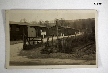
Postcard - POSTCARD - CODFORD AIF CAMP, UK, c1918
Photograph of AIF Codford Camp No. 7. R.H. Baron was stationed here in 1918 during WW1. He later transferred to Herdcott Camp. Part of the Robert H. Baron (No. 3596) and Cooper Collections. See Catalogue No. 1981P for details of Baron's service.Black and white photograph featuring three buildings fronting a gravel road. Two signs appear in the foreground. One is labelled 'No. 7 Camp', the other taller one is labelled 'Salvation Army Rest Hut'. A tree lined hill is in the background.On back, handwritten in black ink: 'Dear Mother, this is the entrance to our camp, the 3rd hut down on the outside is our hut, Robert H. Baron.robert h. baron, cooper collection, postcard, codford aif camp -
 Eltham District Historical Society Inc
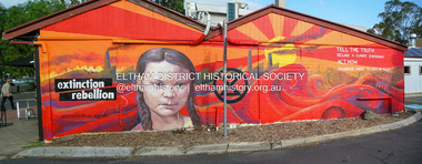
Photograph, Fay Bridge, Extinction Rebellion protest mural, Platform 3095, 965 Main Road, Eltham, 29 January 2020
Extinction Rebellion protest mural painted on the western wall of Platform 3095 cafe facing the railway station Prior to September 2016 a grouping of five trees were planted in the small garden bed on the western end of the cafe in two groups either side of the traffic sign which at that stage was the taller By October 2017 the five trees had doubled in height to about 1m above the roof line By April 2018 the trees were all about 2m above the roof line By August 2019 all five trees had been cut down and the wall was a mixture of paint patches from ongoing graffitti attacks By January 2020 the wall had been adorned with this mural which appears to have discouraged ongoing graffitti attacks but its message is tinged with irony that five healthy young trees were removed fay bridge collection, 2020-01-29, eltham, platform 3095, extinction rebellion -
 Eltham District Historical Society Inc
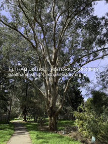
Photograph - Digital Photograph, Significant Tree: Eucalyptus, Stokes Orchard Linear Park, Eucalyptus Road, Eltham, 4 September 2020
The tree is located on the eastern side of Eucalyptus Road, Eltham in the linear park which runs through the Stokes Orchard Estate, approximately 200m from Eucalyptus Road. This is the path of an old creek which originates from near Nyora Road and Stokes Place. Aerial photography taken in November 1931 shows several reasonably well-developed trees, possibly of 20 to 30 years of age beside the water course. The water course and trees were retained in the orchard and these old trees remain standing as of 2024. However, in 2023 Council received a complaint regarding a potential risk with the largest tree even though it had not been known to cause any issue over recent decades but given the public risk concern, Council conducted an assessment and cut it down leaving approximately 10m of the trunk still standing. The major limbs were left 'scattered' around the base for wildlife habitat. The tree remains alive and is now rapidly becoming a tall bushy shrub. The age of the tree is in in excess of 125 years.stokes orchard estate, significant tree, eucalyptus road, eltham, eucalyptus tree -
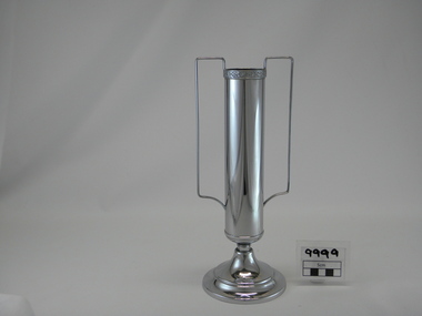 Lorne Historical Society
Memorabilia - Trophy, Phoenix Plate
This trophy was presented to the Chief Engineer of the Great Ocean Road construction project on the occasion of the Official Opening of the Great Ocean RoadSilver Trophy. Tall, cylindrical, with two handles, mounted on circular base. Engraved on circular base "Great Ocean Road. Opened November 26, 1932" On base of trophy, faint writing handwritten on base, "V/693285" Maker's information on underside of base "Phoenix Plate EPNS Made in Australia"trophy, silver, 1932, engineer, opening, great ocean road, gor -
 Halls Gap & Grampians Historical Society
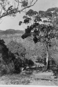
Photograph - B/W, C ?
This is the ford over the Stoney Creek and shelter shed.The photo shows a track leading down to a large pergola type structure, surrounded by thick bush. There is a tall gum on the right of the picture, beside the track. A large branch of a tree can be seen in the top left foreground.access routes, roads -
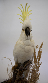 Ararat & District Historical Society (operating the Langi Morgala Museum)
Animal specimen - Sulphur-crested cockatoo, 1913
Full sized sulphur-crested cockatoo specimen, perched on wooden tree branch and surrounded by leaves and grasses. Mounted on a circular polished wooden base with blue rope supporting tall cylindrical glass dome. -
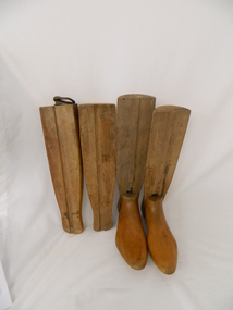 Kiewa Valley Historical Society
Stocks for Riding Boots, Late 1800's to early 1900's
These wooden trees for riding stocks are a concept that was brought to early colonial days from "mother" England. Gentle folk of wealth and status used these trees from early 1800's to keep and maintain their riding boots in their correct form. This form of maintaining the tall riding boot structure was maintained in Australia by the rural "elite" both on cattle properties and smaller cattle stations in the early 1900's. Good riding boots were a status symbol in rural and outback Australia. The riding stocks "wooden trees" are very significant in the Kiewa Valley because they were used by members of some of the original grazing cattle families to settle there. Both cattle and sheep properties occupied large areas of the Kiewa Valley and they also herded their flock and herd on the Bogong High Plains region. These stocks and boots were worn by Fred Roper whose great grand daughter donated them to KVHS. Therefore these boots and stocks would date from 1880's to 1920's and are a good representation of the style of boots worn during this period. This pair of wooden stocks for riding boots trees has been manufactured to a very high standard. Each of the four boot tree parts fit snugly together and maintain their form, and that of the boot that they occupy. The groove channels and foot forms (tongue and groove) are exact and once snapped together become very solid. There is a brass ring, attached by a small brass "peg" on each of the thin "sliding" middle uprights. See KVHS 0177 - Riding boots.On top "L" (for left boot), "R" (for right boot)horse. country. leather. gaiters. high plains. grazing. cattlemen. laces. studs. stocks. roper family. bogong high plains. -
 Eltham District Historical Society Inc
Photograph, Monash Bridge, Arthurs Creek Road, Hurstbridge, Eltham Heritage Tour, 24 May 1992, 24/05/1992
ELTHAM HERITAGE TOUR The Society excursion on 24th May 1992 was arranged by David Bick, leader of the team carrying out the Shire's heritage study. David selected a number of sites or buildings identified in the study, some of them lesser known components of the Shire's heritage. The tour commenced at the Eltham Shire Office at 10.00 am. Travel was by private car and mini-bus with stops at about twelve locations for commentary by David.It included a short walk in Hurstbridge and lunch at Kinglake. Highlights of the tour included: - 10 am Leave from Shire Offices - 3 Important Trees - A Physical Link to Eltham's First Settlers - Toorak Mansion Gates - A Surviving Farm House - An Intact Circa 1900 Main Street - First Settlers - Gold Miners, and Timber-getters - An Early Hotel - A Pioneering Homestead - Changing Eltham Shire - 20th Century - 4 pm Afternoon Tea and Finish Tour Extract from ELTHAM CULTURAL HERITAGE TOUR (Newsletter No. 85, July 1992, by Bettina Woodburn) "On the Arthurs Creek Road is a bridge designed by Monash, which we admired before walking across the little park with a mud-brick and timber shelter, to the Hurst family graveyard. There are two marked graves, one, Henry who was shot by Burke the bushranger and a cairn has a plaque listing others buried here from 1866 onwards. Burke was captured and tied to the wheel of a dray under the eucalypt near the waterhose/standpipe. Close by the kindergarten, at this place are three trees on the National Trust Register, a Canary Island pine, a Canadian cedar and probably a spruce. Radiata pines and a thick bolled peppercorn surround the little cemetery. Continuing along Main Street we notice elm trees planted as a war memorial, then on the left a 1930 timber house, a 1910 store and residence, resplendent with wrought iron trim, a double fronted Hardware Store and cypresses on the back alignment of a new vacant block. On the right side of the street is a less interesting attempt at an 'in character' shop. Further on are more early homes, one tucked away at the rear with two tall palms by the front steps. Another curiosity is a rounded veranda corner and there are more galvanised iron sheds or garages, before a mud-brick Dentist's Surgery. Beyond the round-a-about is St Peters Church, of mud-brick construction shared by Catholic and Anglican parishioners, overlooking the river flood plain. Leaving Hurstbridge on the Kinglake Road, we ate our picnic lunch beside the communication tower and enjoyed views of Melbourne, Yan Yean Reservoir and the distant Dandenongs beyond the spreading suburbs. Next we drove to the North West boundary of the Shire at Masons Falls Road towards Whittlesea. On the way to the North East Boundary we passed St Peters, a yellow wooden Church with a Tudor Archway; built in the early 1920's in the style of the 1860's. From the Healesville-Kinglake road the rolling hills had European aspects, the hedged fields and chestnut trees. Then it was back down the Hurstbridge Road through 'Aussie' bush of towering gums, with bracken and scrubby understorey, the Kinglake National Park, before more open country with deciduous trees planted in line, and a creek lined with willows."Record of the Society's history and activities and highlighting various aspects of the Heritage Study undertaken by David Bick used to create the future heritage overlay for the Shire of Eltham and later Nillumbik Shire.Roll of 35mm colour negative film, 4 stripsKodak Gold 100 5095shire of eltham historical society, activities, heritage tour, hurstbridge, monash bridge, arthurs creek road -
 Orbost & District Historical Society
lantern, 1939?
Blackout lantern used in WW11. This type of lantern was used during both World War. It is an artillery siege lamp and was originally used by artillery units. The lamps were powered by a single candle, the light being magnified by a lens. A shutter closes over the lens to give an illuminated vertical line. They were used originally in fortified siege artillery positions as a general purpose lamp. They were also used as aiming lamps when they were placed in front of artillery positions and used as a guide in aiming at night. These lamps were often used on the front of bicycles to guide at night. Donated by Clem Heather. Forestry Commision, carved faces on trees with axe., builder of tall. spliced single pole fire towers. This item is considered rare and important. It is historically and technically siginficant at a national level.Small black metal blackout lantern with handle. Front of lantern has round shield with small slit - small door at side for easy lighting of candle. It is hand held or placed on flat area, open base so candle can be inserted and 'screwed' in. Front is a magnifying glass and it has metal lens cover with vertical slit. lantern blackout ww11 military candle-power lamp -
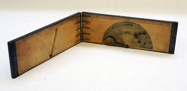 Orbost & District Historical Society
clinometer rule, mid 19th -earl 20th century
This clinometer, is a hand-held optical scientific instrument used in surveying to measure vertical angles. It is used to measure the angle of elevation from the ground in a right-angled triangle. It may have been used by a surveyor or a forester to measure the height of tall things where you couldn't possibly reach to the top of e.g. flag poles, buildings or trees.This item is an example of an early hand held measuring instrument.. Today the use of electronic sensors is an important component in the design and function of the clinometers.A rectangular wooden folding measuring instrument. the panels are brass framed. Inside is a brass semi-protractorgraduated 90-0-90' with index arm pointeran dwith a graduated edge in inches. Outside is a temperature conversion scale,Troughton & Simms, LONDONscientific-instrument measurement clinometer -
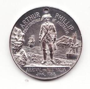 Learmonth and District Historical Society Inc.
Medal - Australia 150th, Medal - Australia's 150th Anniversary, 1938
This medal commemorates the 150 years of Australia and the first govenor of Australia, Arthur Phillip, he arrived with the First Fleet along with 729 convicts.Celebrates the 150th of Australia and the first govenor of Australia, Arthur Phillip. 1788 - 1938This medal was struck in 1938 to commemorate the 150th anniversary of British settlement of Australia. It depicts Australia standing with the sun behind her head. At her feet kneel two men, one representing industry (with tools, city buildings and shipping) and the other representing agriculture (with sheep, fruit, silos and an aircraft). It is a round medal which is silver plated.Obverse - Australia standing with front arms raised, sun behind her head, men representing industry and agriculture kneel at her feet, biplane in sky on right, tall building on left; inscribed with "Australia's 150th Anniversary 1938 and the initials C.E on the lower left. Reverse - Figure of Govenor Arthur Phillip standing on the shore, left rocks with the makers name, Amor, in the background is a ship on the left, right hill with trees and a long boat with a sailor, under this the letters C.E.australia 150th, govenor arthur phillip -
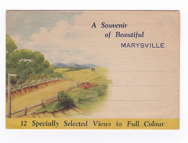
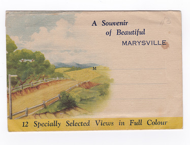 Marysville & District Historical Society
Postcard (item) - Colour photographs, Nucolorvue Productions, A Souvenir of Beautiful Marysville-12 Specially Selected Views in Full Colour, 1950's
An envelope of 12 colour photographs of attractions in and around Marysville in Victoria.An envelope of 12 colour photographs of attractions in and around Marysville in Victoria. These photographs were produced by Nucolorvue Productions in Mentone, Victoria.A Souvenir of Beautiful MARYSVILLE 12 Specially Selected Views in Full Colour Marysville, Victoria, Australia Marysville, 60 miles from Melbourne, is one of nature's/ lovely beauty spots. The invigorating mountain air helps the/ visitor to enjoy the many delightful walks amongst the tall/ timber, or through the fern glades. Apart from many excellent walking trips, Marysville district/ offers ample scope for car trips to the nearby Cumberland Forest,/ Buxton, Narbethong, or the Taggerty Valley. Skiers find Lake Mountain an attraction in the winter, whilst/ the hiker finds ample for his needs in the numerous mountain/ areas. Huge Eucalypt trees, revealing their ramrod straightness up/ to 300 feet in height, are a fitting background to the many/ beautiful creeks and waterfalls. PUBLISHED BY NUCOLORVUE PRODUCTIONS, MENTONE, VICTORIA.nicholl's lookout (image 1), eildon weir (image 2), road to lake mountain (image 3), foot of steavenson falls (image 4), steavenson falls (image 5), bush scene near marysville (image 6), bush track marysville (image 7), bridge and chalet and crossways marysville (image 8), log cabin at marysville (image 9), black spur (image 10), taggerty river (image 11), highest known hardwood tree (image 12), marysville, victoria, nucolorvue productions, postcard, souvenir -
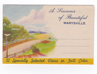
 Marysville & District Historical Society
Postcard (item) - Colour photographs, Nucolorvue Productions, A Souvenir of Beautiful Marysville-12 Specially Selected Views in Full Colour, Unknown
An envelope of 12 colour photographs of attractions in and around Marysville in Victoria.An envelope of 12 colour photographs of attractions in and around Marysville in Victoria. These photographs were produced by Nucolorvue Productions in Mentone, Victoria.A Souvenir of Beautiful MARYSVILLE 12 Specially Selected Views in Full Colour Marysville, Victoria, Australia Marysville, 60 miles from Melbourne, is one of nature's/ lovely beauty spots. The invigorating mountain air helps the/ visitor to enjoy the many delightful walks amongst the tall/ timber, or through the fern glades. Apart from many excellent walking trips, Marysville district/ offers ample scope for car trips to the nearby Cumberland Forest,/ Buxton, Narbethong, or the Taggerty Valley. Skiers find Lake Mountain an attraction in the winter, whilst/ the hiker finds ample for his needs in the numerous mountain/ areas. Huge Eucalypt trees, revealing their ramrod straightness up/ to 300 feet in height, are a fitting background to the many/ beautiful creeks and waterfalls. PUBLISHED BY NUCOLORVUE PRODUCTIONS, MENTONE, VICTORIA.nicholl's lookout (image 1), eildon weir (image 2), road to lake mountain (image 3), foot of steavenson falls (image 4), steavenson falls (image 5), bush scene near marysville (image 6), bush track marysville (image 7), bridge and chalet and crossways marysville (image 8), log cabin at marysville (image 9), black spur (image 10), taggerty river (image 11), highest known hardwood tree (image 12), marysville, victoria, nucolorvue productions, postcard, souvenir -
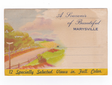
 Marysville & District Historical Society
Postcard (item) - Colour photographs, Nucolorvue Productions, A Souvenir of Beautiful Marysville-12 Specially Selected Views in Full Colour, Unknown
An envelope of 12 colour photographs of attractions in and around Marysville in Victoria.An envelope of 12 colour photographs of attractions in and around Marysville in Victoria. These photographs were produced by Nucolorvue Productions in Mentone, Victoria.A Souvenir of Beautiful MARYSVILLE 12 Specially Selected Views in Full Colour Marysville, Victoria, Australia Marysville, 60 miles from Melbourne, is one of nature's/ lovely beauty spots. The invigorating mountain air helps the/ visitor to enjoy the many delightful walks amongst the tall/ timber, or through the fern glades. Apart from many excellent walking trips, Marysville district/ offers ample scope for car trips to the nearby Cumberland Forest,/ Buxton, Narbethong, or the Taggerty Valley. Skiers find Lake Mountain an attraction in the winter, whilst/ the hiker finds ample for his needs in the numerous mountain/ areas. Huge Eucalypt trees, revealing their ramrod straightness up/ to 300 feet in height, are a fitting background to the many/ beautiful creeks and waterfalls. PUBLISHED BY NUCOLORVUE PRODUCTIONS, MENTONE, VICTORIA.nicholl's lookout (image 1), eildon weir (image 2), road to lake mountain (image 3), foot of steavenson falls (image 4), steavenson falls (image 5), bush scene near marysville (image 6), bush track marysville (image 7), bridge and chalet and crossways marysville (image 8), log cabin at marysville (image 9), black spur (image 10), taggerty river (image 11), highest known hardwood tree (image 12), marysville, victoria, nucolorvue productions, postcard, souvenir -
 Marysville & District Historical Society
Photograph (item) - Black and white photograph, 10-1947
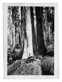
An early black and white photograph taken in the Cumberland Valley near Marysville in Victoria.An early black and white photograph taken in the Cumberland Valley near Marysville in Victoria. The Cumberland Valley is near Cambarville which was a timber town near Marysville. Cambarville is notable for its giant mountain ash (Eucalyptus regnans) trees within the Cumberland Memorial Scenic Reserve, and relics from former sawmills and gold mining. The Big Culvert is located nearby on the Marysville - Woods Point Road, which was historically part of the Yarra Track. Cambarville was established as a timber mill town in the 1940s. Timber mill owners A Cameron and FJ Barton named Cambarville. They established the mill to salvage timber from trees destroyed in the 1939 bushfires. Cambarville was impacted by the 2009 Black Saturday bushfires and any remaining structures were destroyed.Among Tall Timber at/ Cumberland Valley. Oct.47. 39cumberland valley, marysville, victoria, cumberland creek, mountain ash, timber mill, mining, a cameron, fj barton, cambarville, big culvert, yarra track, black saturday bushfires, 1939 bushfires, photograph -
 Glen Eira Historical Society
Photograph, Beauville Avenue, 34, Murrumbeena, 2001
Originally labelled "Beauville Estate, Established 1936, Still Thriving 65 years on, 10th March 2001", the Beauville Estate Album contains colour photographs of houses in the Estate. They were taken around the time of the Beauville Estate’s 65th Heritage Celebration held on 10/03/2001 and donated to the Caulfield Historical Society shortly afterwards. Photographer unknown.City of Glen Eira’s Heritage Management Plan Vol 2 p79 (this is p84 of the pdf version) – HO12 Beauville Estate and environs, Murrumbeena: The Beauville Historic Area is important at the State level as the first large housing estate undertaken by the AV Jennings Construction Co, later Jennings Group Limited, Victoria’s largest home builder. It is important also as a very early estate development incorporating a range of features other than houses and including made roads, shops and recreation facilities. In this respect it was the forerunner of the comprehensively planned housing estate of the post war era. The estate is distinguished by its aesthetic values, as is the earlier and comparable Hillcrest Estate, which are formed by a combination of restrained diversity in house styles, with the exception of no. 30 in the emerging International style, and by a landscaped garden environment. Colour photograph of white rendered, corner house with unpainted variegated brown brick features. Other features include a wide arched porch, tiled roof, tall brick chimney, cast iron work black porch door, window awnings and low unpainted matching brick fence in the foreground with "34" on the white metal letterbox on top of the right brick pillar beside the concrete pathway leading to the porch. Well-established garden including 2 matching pencil pines.murrumbeena, houses, beauville avenue, architectural styles, 1930's, inter war style, a.v. jennings, av jennings, jennings, brick houses, beauville estate, porches, sir albert victor jennings, a v jennings construction co, beauville estate heritage area, glen eira city council, architectural features, jennings group limited, land subdivision, gardens, beauville historic area, rendered houses, corner houses, brick features, awnings, brick fences, metal letterboxes, trees, cast iron work door -
 Glen Eira Historical Society
Photograph, Murrumbeena Road, 232, Murrumbeena, 2001
Originally labelled "Beauville Estate, Established 1936, Still Thriving 65 years on, 10th March 2001", the Beauville Estate Album contains colour photographs of houses in the Estate. They were taken around the time of the Beauville Estate’s 65th Heritage Celebration held on 10/03/2001 and donated to the Caulfield Historical Society shortly afterwards. Photographer unknown. City of Glen Eira’s Heritage Management Plan Vol 2 p79 (this is p84 of the pdf version) – HO12 Beauville Estate and environs, Murrumbeena: The Beauville Historic Area is important at the State level as the first large housing estate undertaken by the AV Jennings Construction Co, later Jennings Group Limited, Victoria’s largest home builder. It is important also as a very early estate development incorporating a range of features other than houses and including made roads, shops and recreation facilities. In this respect it was the forerunner of the comprehensively planned housing estate of the post war era. The estate is distinguished by its aesthetic values, as is the earlier and comparable Hillcrest Estate, which are formed by a combination of restrained diversity in house styles, with the exception of no. 30 in the emerging International style, and by a landscaped garden environment. Colour photograph of an unpainted variegated brown brick house. Other features include a tall chimney, tiled roof, white framed sash windows with striped awnings, low unpainted brick fence in the foreground with "232" on the brick pillar and a brown wooden gate beside the driveway. Bushes and trees obscure most of the house.murrumbeena, houses, architectural styles, 1930's, inter war style, a.v. jennings, av jennings, jennings, brick houses, beauville estate, murrumbeena road, sir albert victor jennings, a v jennings construction co, beauville estate heritage area, glen eira city council, architectural features, jennings group limited, land subdivision, gardens, beauville historic area, chimneys, sash windows, striped awnings -
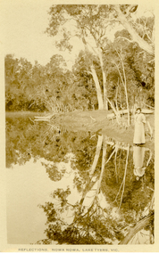 Federation University Historical Collection
Postcard, Howard D. Bulmer, Reflections, Nowa Nowa, Lake Tyers, Victoria
Nowa Nowa is located in Victoria on the Princes Highway between Lakes Entrance & Orbost. Tall eucalypts stand guard as you drive into this small village.The fresh waters of Boggy Creek and the tidal waters of Lake Tyers meet here. In the past its history was of logging. Black and white post card showing a lady in long skirt standing on the banks of a river with Australian eucalypts (gum tress) in the background and reflected in the water. nowa nowa, lake tyers, trees, river -
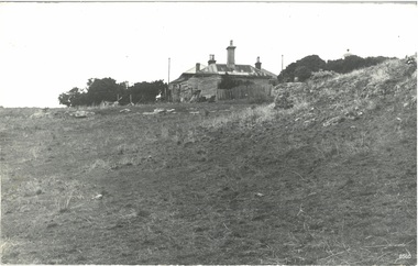 Flagstaff Hill Maritime Museum and Village
Photograph - Historical, Port Fairy Lighthouse Keepers Cottage, Late 19th to early 20th centuries
The late 19th to early 20th century stone cottage with weatherboard extensions. From research, it has been determined that the cottage was the Port Fairy (Belfast) Lighthouse Keepers cottage. The dome roof in the background indicates a lighthouse, in which case the cottage would have been the living quarters for a lighthouse keeper and assistant keeper. The narrow poles could have been for signals and antennae. The object on the rock stack looks like a large metal milk can.The photograph shows a typical late 19th to early 20th century cottage, abandoned at dilapidated for many years. Black and white rectangular photograph mounted on card. The image shows a dilapidated stone cottage with an old picket fence. Extending behind the stone cottage are gabled roofs above weatherboard walls. The cottage has corrugated roof sheets of different colours, and four chimneys, three with chimney pots. From research, it has been determined that the cottage was the Port Fairy (Belfast) Lighthouse Keepers cottage. Near the fenceline on the left, a corrugated water tank is positioned below a pipe joined to the roof gutter. Nearby are a timber shed and timber walls or screens. In the background are two tall narrow poles with spheres on top, higher than the cottage, with one pole on each side, the left one attached to the building. A domed roof with a knob on top is on the right behind trees. Several angular shapes appear on the horizon on the left, one almost hidden by the trees. The foreground is rocky and slopes uphill on the right. At the foot of the slope is a stack of closely fitted rocks with an object shaped like a milk can on top and an object to its left that is like an open grid. Handwritten Inscriptions are on the reverse side of the photograph.Pencil on board: " D9 / 200 x 150" Pen on sticker: "52"flagstaff hill maritime museum and village, warrnambool, great ocean road, shipwreck coast, cottage, lighthouse, iron roof, stone building, picket fence, water tank, weatherboard building, 19th century cottage, early 20th century cottage, abandoned cottage, antenna, chimneys, milk can -
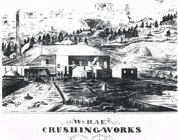 Bendigo Historical Society Inc.
Document - LONG GULLY HISTORY GROUP COLLECTION: WM RAE CRUSHING WORKS
Sketch of a crushing works. Printed underneath is: Wm. Rae's Crushing Works, Happy Valley, Bendigo. Written on the back is: Happy Valley Rd. South side below Wells St. Picture shows a crushing works building with a tall chimney and some smaller outbuildings. On the hill in the background are poppet legs, other mine structures and some trees. There are heaps of mullock and in the foreground are a number of people.bendigo, history, long gully history group, the long gully history group - wm rae crushing works, george ellis -
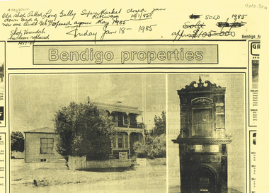 Bendigo Historical Society Inc.
Document - LONG GULLY HISTORY GROUP COLLECTION: A VICTORIAN DREAM HOME
Photocopy of a newspaper article titled A Victorian dream-home by Richard Foord. The article is an estate agent, Craig Tweed & Co Pty Ltd, ad about a house called Kilhallen which had been in the Truscott family for four generations. The house and the building materials are described. A photo shows the back of the two story house with a small room added on at the back. On the back of the page titled Bendigo properties is a photo of a two story house with ironlace on the verandas, a tree partly obscuring the house and a single story weatherboard building beside it. An auction sale sign is on the front fence. The second photo shows an ornate fireplace with tall carving above it. Written at the top of the page is: A Truscott. Old shop pulled down and a new one built Feb 90. Shop verandah has been replaced 1987-88. Long Gully Super Market Riteway Jan 14/1/85. opened again May 1985. Friday Jan 18 1985. Sold 1985.bendigo, history, long gully history group, the long gully history group - a victorian dream home, richard foord, anthony truscott, kilhallen, craig tweed & co pty ltd -
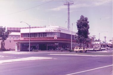 Bendigo Historical Society Inc.
Photograph - CASTLEMAINE GAS COMPANY COLLECTION: PHOTO SEC BUILDING
Photo of SEC Building at the corner of Williamson and Hargreaves Streets. Tree planted on the roundabout, Tall communications tower in the background, two people standing the safety zone, white station wagon, other cars parked along Williamson Street.bendigo, streetscape, williamson street -
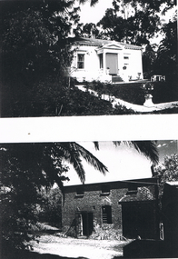 Bendigo Historical Society Inc.
Photograph - LONG GULLY HISTORY GROUP COLLECTION: TWO HOUSES
Photos of two houses on a piece of paper. The top photo is a white house with a portico and steps at the front door, a window at each side and a striped blind at the edge of the portico. Decorative brick work at spout level. A concrete path is along the front of the house and leads out to the front and side. A vase with a flower and a statue on the corner of the path. there is a table and chairs beside the house. The garden is very black. The lower photo is a brick house with a door, a tall window that is rounded at the top and three small windows just below the spout line. There are some plants in front of the house and trees around it. parts of the garden are dark.bendigo, history, long gully history group, the long gully history group - two houses -
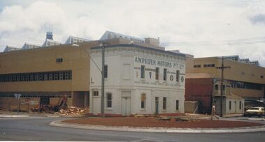 Bendigo Historical Society Inc.
Photograph - A.W.PULFER MOTORS PTY LTD: CORNER OF MUNDY AND HARGREAVES STREET, BENDIGO
Black and white photograph, rendered brick 2 storey building, parapet, single storey section at back with tall square brick chimney. Includes bus shelter, electricity pole with transformer. 2 small trees plnated in nature strip. Rocks around trees. ' The Technical and Further education 'Ted Thompson'building under construction C 1982. In the centre is the former Royal Princess Hotel (now shown as A. W. Pulfer Motors), on the corner of Mundy and Hargreaves Streets which was demolished in February 1983. Specimen Cottage is to the right. ' On back '11' Ward/A/FSP/1204' 'O'organization, education, tafe college -
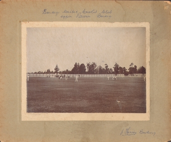 Bendigo Historical Society Inc.
Photograph - UPPER RESERVE - BENDIGO UNITED CRICKET CLUB, 1901
Black and white photograph. Cricket scene. Trees and sky in background. Cricket ground (lawn), with tall fence in background. Eleven figures are on field. Inscriptions: on front - 'Bendigo United Cricket Club, Upper Reserve Bendigo', 'J Harry Bowling'.person, group, sports team -
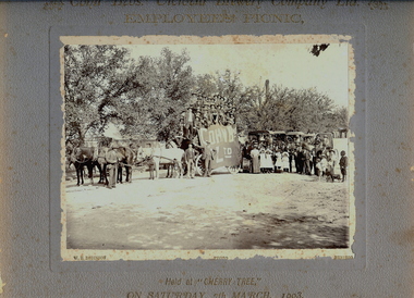 Bendigo Historical Society Inc.
Photograph - COHN BROS. EMPLOYEES PICNIC, 7th March, 1903
... 'Cohn Bros Ltd'. Trees in background. Tall chimney in distance...'. Trees in background. Tall chimney in distance. Inscriptions ...Black and white photograph on grey board. Large number (approx 27) of males on 4 horse drawn wagon, buggies with passengers in background. Men, women and children standing at front. One male has a bass drum. Banner on side of vehicle reads 'Cohn Bros Ltd'. Trees in background. Tall chimney in distance. Inscriptions: Front - printed on mount board 'Cohn Bros Victoria Brewery Company Ltd, Employees Picnic, held at Cherry Tree on Saturday 7th March, 1903', WH Robinson Photo, Bendigo', On back - 'Royal Historical Society of Victoria, Bendigo Branch', '1959, 71'. Photograph missing from this file 6/05/2021.WH Robinson Photo, Bendigoperson, group, picnic group -
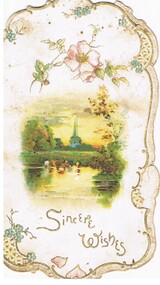 Bendigo Historical Society Inc.
Ephemera - MALONE COLLECTION: GREETING CARDS, 1915
Shaped white card with coloured rural scene of some cattle having a drink at the stream. There are trees and a building with a tall spire in the background. Above the scene is a stem of pink flowers and below, printed in gold is: 'Sincere Wishes'. The edges of the card are decorated with gold, cutouts and small blue flowers. At the bottom are some pink petals.Raphael Tuck & Sons Ltdperson, greeting cards, malone collection, malone collection, greeting cards -
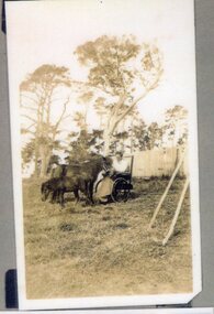 Churchill Island Heritage Farm
Photograph - Photograph of man and horse
Churchill Island Heritage Farm has a large photographic collection dating from the nineteenth century. This series showcases photographs taken in the 1930s and 1940s and shows people who lived and worked on the Island during the Jenkins period. This photograph shows Ted Jenkins - the son of the owner of the Island - feeding Winks, a pony who was often hitched to a small cart for Ted to use while moving around the Island.Sepia photograph with white border showing a man in a wheelchair feeding a small pony, with a foal standing close. The group are in front of a tall white picket fence, with large trees in the background. Digitised from a high resolution copy (original Polaroid is in poor and fragile condition)nilchurchill island, photograph, arthur evans, ted jenkins, horse