Showing 1871 items matching "the crescent"
-
 Whitehorse Historical Society Inc.
Document - Sketch and descriptions, The old cottage, 1/10/1993
Sketch and descriptions of the old cottage, near the present Irene Crescent by N. Jamieson from advice of Arthur Schwerkolt 1993.schwerkolt cottage, jamieson, norma, schwerkolt, arthur -
 Whitehorse Historical Society Inc.
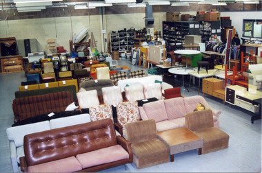
Photograph, Whitehorse Emergency Relief Network
The Nunawading Ladies Benevolent Society became the Whitehorse Emergency Relief Network in 1999, when a number of local organizations were encouraged to form a network by Betty and Keith Rooney. The object was to collect domestic items of good quality to assist people in need, especially women who have been the victims of domestic violence.Coloured photograph of the interior of the Whitehorse Emergency Relief Network 10-12, Thornton Crescent, Nunawading. Domestic goods showneastern emergency relief centre, thornton crescent mitcham nos 10-12 -
 Ringwood and District Historical Society
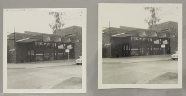
Photograph, Ringwood North State Bank , north-east corner of Dickson's Crescent and Warrandyte Road
The new Ringwood North State Bank premises on the north-east corner of Dickson's Crescent. Exterior view. Unknown date.At the corner of Dickson's Cresent and Warrandyte Road, Ringwood North. -
 Ringwood and District Historical Society
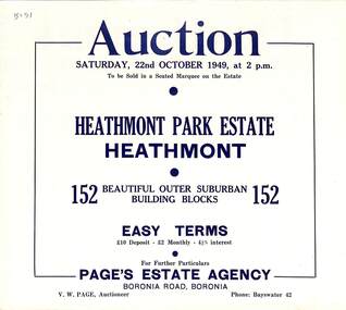
Flyer, Land Auction Sale Brochure, Heathmont Park Estate, Heathmont, Vic. - 1949
Double sided multi-fold advertisement for auction sale of residential allotments, including summary of subdivision features and local facilities. Auction on Saturday, 22nd October, 1949, at 2 p.m.Subdivision includes Great Ryrie Street, Erica Crescent, Neil Street, Frances Street, Viviani Crescent, and Canterbury Road. Agent - Page's Estate Agency, Boronia Road, Boronia. Phone Bayswater 42. -
Whitehorse Historical Society Inc.
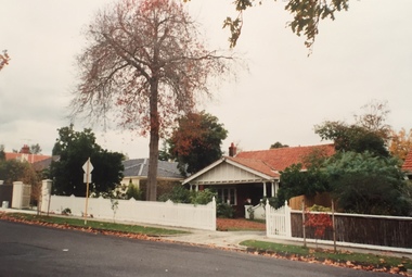
Article, Gordon Crescent Blackburn, 9/10/2012 12:00:00 AM
Sale advertisement for 2 Gordon Crescent Blackburn, former home of Thomas Richard Burrowes Morton.Sale advertisement for 2 Gordon Crescent Blackburn, former home of Thomas Richard Burrowes Morton. Agent: Noel Jones Blackburn.Sale advertisement for 2 Gordon Crescent Blackburn, former home of Thomas Richard Burrowes Morton. gordon crescent blackburn, no. 2, morton, thomas richards burrowes -
 Kew Historical Society Inc
Photograph - Carson Street, Kew, 1993
A series of five photographs of streetscapes in Kew in 1993, of which this is one, focus on footpaths and gutters, so while the provenance is uncertain, it is presumed that they were created in the office of City Engineer in the City of Kew.Colour positive print of Carson Street, which runs between Studley Park Road and Findon Crescent, dating from 1993carson street -- kew (vic.) -
University of Melbourne, Burnley Campus Archives
Work on paper (item) - Student Work, Xueli Ruan, Sunbury Crescent Landscape Design, 2016
Created as an assignment for HORT90035 'Landscape Construction and Graphics,' a subject at Burnley Horticultural College coordinated by Andrew Laidlaw. There may be a sheet missing because usually these assignments would have three sheets. There was however a marking rubric found with the project. assignment, landscaping, burnley, 'landscape construction and graphics' -
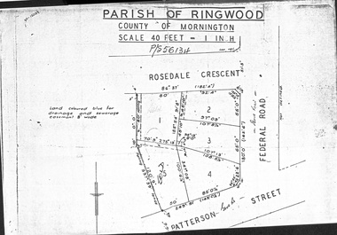 Ringwood and District Historical Society
Document - Folder, Map of Subdivision for auction - Ringwood East, Vic., 1973
Photocopy of Parish Map showing five residential blocks for sale on Rosedale Crescent, Federal Road and Patterson Street Ringwood East.Accompanying handwritten sales notes researched in 2024 by Richard Carter - Carter Real Estate - "5 lots (heavily filled) auction 14 July 1973. All later sold $4000 each - unknown agent". -
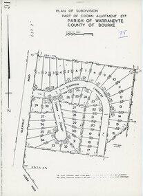 Ringwood and District Historical Society
Map - Plan of Subdivision, Part of Crown Allotment 27B Parish of Warrandyte County of Bourke (undated, circa 1970)
Photocopied subdivision map of 38 residential allotments in Glenvale Road, Cantala Crescent, and Giana Court, north of Kubba Road, Ringwood. -
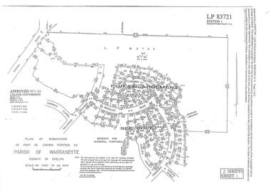
 Ringwood and District Historical Society
Document - Subdivision Plan, LP83721 - Part of Crown Portion 23, Parish of Warrandyte, County of Evelyn - 1969
A4 LANDATA Land Victoria plan printout dated 2009Two A4 maps of residential subdivision off Wonga Road, Ringwood. Enlargement map includes Holyrood Crescent, Berkley Road, Carmen Court, Frederic Drive, Kenwood Crescent, Marilyn Street and Adele Court. -
Clunes Museum
Book, NATIONAL TEMPERANCE PUBLICATION DEPOT, KIRTON'S TEMPERANCE TALES
KIRTON'S TEMPERANCE TALES FOR THE PEOPLERED DECORATED HARD COVER BOOK - KIRTON'S TEMPERANCE TALES FOR THE PEOPLEKIRTON'S TEMPERANCE TALES FOR THE PEOPLElocal history, book, religious, books, religion -
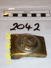 Rye RSL Sub Branch
Belt Buckle Brass Turkish Officer
Brass belt buckle similar in style to the German equivalent. Thought to have belonged to a Turkish Officer.It has an embossd Crescent and Star emblem. -
 Ballarat Heritage Services
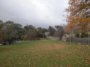
Photograph - Colour, Clare Gervasoni, Borsa Crescent, Hepburn Springs, from Bellinzona, 2004, 28/06/2004
The block of land depicted has been leveled with a huge rock barrier around the corner perimeter.Block of land on the corner of Borsa Crescent and Seventh Street taken not long after Bellinzona and Wanda Inn had been burnt down.bellinzona, actea, hepburn springs, church avenue, seventh street, borsa crescent, wanda inn, fire -
 Brighton Historical Society
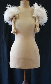
Cape, Capelet, circa 1920
This capelet belonged to Ellen Grace Snowball, nee Anketell, (1866-1945), who lived with husband Oswald Robinson Snowball (1859-1928) at 'Wolsingham', 11 Boxshall Street, Brighton. Oswald Snowball was a solicitor and politician who was active in the Freemasons and the Orange Order. Active in Protestant moral crusades during the 1990s, he was a vocal opponent of liquor and gambling and advocated Bible reading in public schools. In 1909 he succeeded Sir Thomas Bent as Brighton's representative in the Victorian Legislative Assembly, a seat he held for close to twenty years until his death in 1928. During his last year of life, despite serious illness, he served as Speaker of the Legislative Assembly under the Hogan government.White ostrich feather capelet. Feathers sewn onto crescent-shaped cream cotton fabric, with an elaborate silk tassel at either end.ellen grace snowball, ellen grace anketell, oswald snowball, capelet, ostrich feather, 1920s -
 Wangaratta RSL Sub Branch
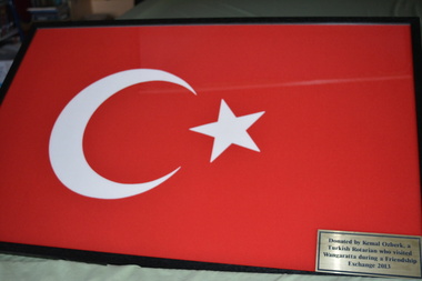
Flag - Framed Flag
Turkish Flag donated to Wangaratta RSL by Kemal Ozberk a visiting Rotarian from Turkey in 2013Black timber frame containing red cloth with a white star and large crescent shape. Metal plaque attached on lower right cornerPlaque - Donated by Kemal Ozberk, a Turkish Rotarian who visited Wangaratta during a friendship exchange in 2013turkish, flag -
 Ringwood and District Historical Society
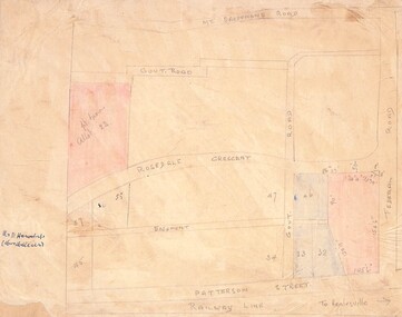
Drawing - Hand-drawn map, Part of Crown Allotment 22, Ringwood East, Victoria (Undated)
Pencil drawing on light cardboard backing. Colour-shaded residential allotments on Rosedale Crescent, Patterson Street and Federal Road, Ringwood East.(Railway line to Healesville marked on the map indicates creation date precedes closure of line beyond Lilydale in 1980) -
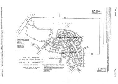
 Ringwood and District Historical Society
Document - Subdivision Plan, LP83721 Part of Crown Portion 23, Parish of Warrandyte, County of Evelyn, Vol 8708 Fol 351, Vol 8745 Fol 148 and Vol 8751 Fol 034 - 1969
Double sided LANDATA Land Victoria 2-sheet plan printout dated 2009Sheet 1 map and Sheet 2 enlargement including Wonga Road, Holyrood Crescent, Harwick Close, Berkley Road, Frederic Drive, Kenwood Crescent, Adele Court and Marilyn Street, Ringwood. Markings also include LP83722 . -
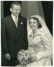 Ringwood and District Historical Society
Photograph, Mr McCann - Miss Penrose wedding photograph
Black and white photograph"Written on back of photograph" Mr McCann -Casterton, Miss Penrose - 9 Grant Crescent Ringwood -
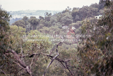 Eltham District Historical Society Inc
Photograph, Michael Wood, View south from 184 Progress Road to houses on Scenic Crescent, Eltham North, February 1970, 1970
Wood family home (1969-2011) pre and post construction by Knox and HellemonsKodachrome 35mm colour transparency in cardboard mount Processing date FEB70M6Inscribed in ink "View south from 184 Progress to Scenic Crescent, Eltham North 1970"alistair knox design, eltham north, hellemon, houses, progress road, scenic crescent -
 St Kilda Historical Society
Photograph - Photograph Building, Donald McDonald, Charnwood House
Built for Rt Hon David J Moore, JPblack and white photographCharnwood Crescent, taken 1872, built1853, Rt Hon David J Moore JP, Residence -
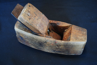 Anglesea and District Historical Society
Wooden Plane
A tool for shaping wood - to flatten/reduce the thickness of and leave a smooth surface on a rough piece of timber.ALEX MATHIESON & SON / WARRANTED (on guide) SOLID STEEL WARRANTED (on blade) Trademark crescent and starplane, tool -
Ringwood and District Historical Society
Contracts, Acquisition of the land in Grey Street and Ware Crescent, Ringwood East by the Graduates Assoc. of the Kindergarten Training College, Melbourne. 1950-1960, 1950-1960
... , Ringwood East by the Graduates Assoc. of the Kindergarten Training ...Various papers from the titles Office, City of Ringwood Solicitors for accounts on the purchase of the land by the Graduates of the Kindergarten Training College and caveats pertaining to the land. This was the site of the Warrawong day and residential care kindergarten which was demolished c.2000 to be divided into housing blocks.18 pages of documents relating to the acquisition of the land in Grey Street and Ware Crescent, Ringwood East by the Graduates Assoc. of the Kindergarten Training College, Melbourne. -
Whitehorse Historical Society Inc.
Document, Schwerkolt Cottage, 1953, 1995
Sketch of Schwerkolt's cottage by Arthur Schwerkolt. Photograph of Myra Schwerkolt taken in 1953 outside old cottage which was on land at end of Irene Crescent.Sketch of Schwerkolt's cottage by Arthur Schwerkolt. Photograph of Myra Schwerkolt taken in 1953 outside old cottage which was on land at end of Irene Crescent.Sketch of Schwerkolt's cottage by Arthur Schwerkolt. Photograph of Myra Schwerkolt taken in 1953 outside old cottage which was on land at end of Irene Crescent.schwerkolt cottage, schwerkolt, myra -
Whitehorse Historical Society Inc.
Article, Piece of History bought
Morton House at 2 Gordon Crescent Blackburn.Morton House at 2 Gordon Crescent Blackburn which was built by the Morton Family in 1888, was sold before auction for $2.4 million in Feb 2016.Morton House at 2 Gordon Crescent Blackburn. gordon crescent, blackburn no. 2 -
 Kew Historical Society Inc
Photograph - Carson Street, Kew, 1993
A series of five photographs of streetscapes in Kew in 1993, of which this is one, focus on footpaths and gutters, so while the provenance is uncertain, it is presumed that they were created in the office of City Engineer in the City of Kew.Colour positive print of Carson Street in Kew, dating from 1993. Carson Street runs between Studley Park Road and Findon Crescent.carson street -- kew (vic.) -
Canterbury History Group
Ephemera - 13 Chaucer Crescent Canterbury, 1998
Real estate advertisment for the sale of 13 Chaucer Crescent Canterbury in 1998. Includes coloured photographs of the interior and exterior of the house and floor and site plans.canterbury, chaucer crescent, swimming pools -
Surrey Hills Historical Society Collection
Map, Contour map of Surrey Hills showing potential sites for the Telecom Tower
The PMG / Telecom / Telstra tower was built in 1961-1963 as a relay station to support television and radio links between city and regional broadcasting stations. The tower itself was 45 m in height with a 2 storey building for equipment and staff surrounded by garden. From the beginning it was opposed by local residents. The location is said to be the second highest site in Melbourne, sometimes described as Delaney's Hill.Two A3 photocopied sheets of a map showing part of Surrey Hills, roughly between Windsor Crescent and Belmont Street (north / south) and Standard Avenue and Balmoral Crescent (east / west). The map shows contour lines and house sites, 16 of which are numbered. One sheet has been inscribed in top RH corner with notes regarding the significance of the numbers."Contour map of potential sites / for the telecommunications tower which / was eventually sited at 2. / Jock Campbell OBE was our neighbour / at 4 Theodore St when we moved into / the area in 1984. He was responsible in his / job at the PMG in deciding on the /site of the tower - Note site 5 was / behind his (& our) house. / Jack ended his career as Deputy Director / of the PMG. He sat on international committees / after WW2 to decide the split of the electronic / spectrum for radio, TV etc. / His group developed a "mobile phone" using / fixed towers but the phone was a truck full of gear."contour map, telecom tower, maps, jock campbell, john duncan campbell -
 Bendigo Military Museum
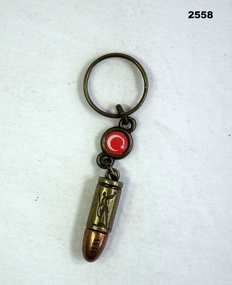
Memorabilia - KEYRING WW1, Possibly 1915 on
Souvenir from ANZAC Cove featuring a Turkish badge with a white crescent & star. Attached is a replica copper bullet stamped with a soldier holding a rifle & inscription,Stamped “Canakkale / Gecilmez & 18 Mart 1915” on bullet point.personal effects - keyrings, military history - souvenirs, turkish -
 Kew Historical Society Inc
Plan, Studley Heights Estate, 1936
Pru Sanderson, in her groundbreaking ‘City of Kew Urban Conservation Study : Volume 2 - Development History’ (1988), summarised the periods of urban development and subdivisions of land in Kew. The periods that she identified included 1845-1880, 1880-1893, 1893-1921, 1921-1933, 1933-1943, and Post-War Development. These periods were selected as they represented periods of rapid growth or decline in urban development. An obvious starting point for Sanderson’s groupings involved population growth and the associated economic cycles. These cycles also highlighted urban expansion onto land that was predominantly rural, although in other cases it represented the decline and breakup of large estates. A number of the plans in the Kew Historical Society’s collection can also be found in other collections, such as those of the State Library of Victoria and the Boroondara Library Service. A number are however unique to the collection.Subdivision plans are historically important documents used as evidence of the growth of suburbs in Australia. They frequently provide information about when the land was sold on which a built structure was subsequently constructed as well as evidence relating to surveyors and real estate and financial agents. The numerous subdivision plans in the Kew Historical Society's collection represent working documents, ranging from the initial sketches made in planning a subdivision to printed plans on which auctioneers or agents listed the prices for which individual lots were sold. In a number of cases, the reverse of a subdivision plan in the collection includes a photograph of a house that was also for sale by the agent. These photographs provide significant heritage information relating house design and decoration, fencing and household gardens.The ‘Studley Heights Estate’ on the South Side of Studley Park Road was launched in 1936. The seventeen allotments in the subdivision fronted Hyton Crescent and Studley Park Road.subdivision plans - kew, studley heights estate -
 Whitehorse Historical Society Inc.
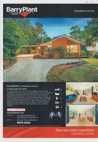
Plan - Residential Building Documents, Drayton and Colman, 1962 Building Documents For the Scambler House in Blackburn, 1962
1962 plans, interior drawings and specifications for G. Scambler's brick house at 16 Wolsley Crescent, Blackburn, and the 2013 Barry Plant Real Estate flyer. The architect was Drayton and Colman.1962 plans, interior drawings and specifications for G. Scambler's brick house at 16 Wolsley Crescent, Blackburn, and the 2013 Barry Plant Real Estate flyer. non-fiction1962 plans, interior drawings and specifications for G. Scambler's brick house at 16 Wolsley Crescent, Blackburn, and the 2013 Barry Plant Real Estate flyer. The architect was Drayton and Colman.scambler gk, drayton & colman architects, wolsley crescent