Showing 4478 items
matching the point
-
 Queenscliffe Maritime Museum
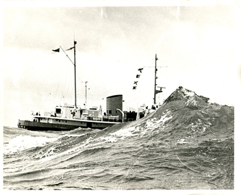
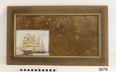
Photograph - Monochrome, MV Wyuna
The ship was built in 1953 by Ferguson Shipbuilders of Port Glasgow, Scotland for the Port Phillip Sea Pilots organisation as a pilot cutter. Her role as a pilot cutter was to sail with pilots on board to meet ships entering Port Phillip Bay. Pilots would be transferred by the Wyuna's workboat to the vessel requiring pilotage while it was stopped dead in the water, with shelter provided by the vessel itself. In the early 1970s the pilot service started using fast launches to allow pilots to board while ships were still underway, and in 1979 the Wyuna was sold to the Australian Maritime College in Launceston, Tasmania as a training vessel. She continued in that role until 2004 when sold to Mineralogy Pty Ltd as an accommodation vessel. In September 2013 she was donated to the Western Port Oberon Association for the Victorian Maritime Centre currently at Crib Point. For a time she was docked at Beauty Point, Tasmania, and after being refurbished for 18 months she was to be moved to Docklands in Melbourne, Victoria. After this berth became unavailable the vessel was docked at Inspection Head Wharf in Beauty Point. After a period there it was towed into Bell Bay where she lays at anchor as of January 2016. When funding becomes available the Western Port Oberon Association has plans to display the vessel in a wet berth alongside the former Royal Australian Navy Oberon-class submarine HMAS Otama.Mr Henry HudsonBlack and white photograph of the Pilot Tender MV Wyuna partially obscured by a large wave at the rip, entrance to Port Phillip Bay.mv wyuna, port phillip pilot service, the rip, the heads, queenscliff, point lonsdale -
 Bendigo Historical Society Inc.
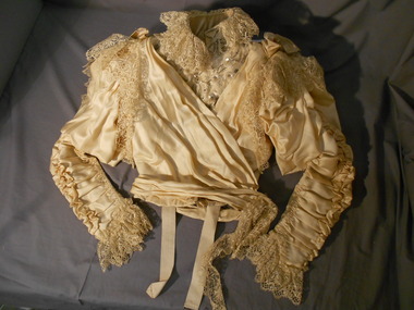
Clothing - BODICE (WEDDING DRESS), 1896
Probably 1890's to early 1900's. The Dress and Mantle Makers departments was part of F. Davey and Co. and the department was run by Miss Middleton, formerly of the Beehive. F Davey and Co. sold their View Point premises in Oct 1904.Bodice (Wedding dress), hand and machine stitched. Silk lined with polished cotton. Slim ruched sleeves - ruched at inner and elbow side of sleeve (hand sewn). Elbow edge of ruching forms two ''frilled pleats'' down the sleeve to the wrist. Wrist edge lily pointed and finished with a 9 cm underfill of cotton lace. Top of sleeves have a leg-o-mutton balloon effect panel sewn at the shoulder and the upper arm. This balloon effect hangs down over the sleeves almost to the elbow. Top of sleeve has an embroidered lace frill hanging over armhole. Two silk bows are placed at the shoulders. Stand-up collar,5 cm deep is finished on each side with a pearl and glass beaded bow motif- 6cm in diameter. Hook and eye fasteners down front-metal loops covered with button hole stitch. Bodice boned with thirteen (13) ''bones''. Each pocket finished with a fan pattern stitching. Linen panel, with a diamond shaped weave stitched at each underarm. Front bodice is pleated from shoulders to centre front. Right front laps across left to fasten with a hook on the left shoulder. This panel is heavily beaded with glass beads and sequins. Over panel from right shoulder fastens with hook and eye at left hip line,with the pleated panel circling the waist.Matching skirt 11400.315.F.Davey & Co, Dress & Mantle Makers, View point, Sandhurst Label stitched at inside waistline of bodice.costume, female, wedding dress bodice -
 Bendigo Historical Society Inc.
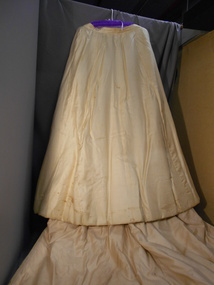
Clothing - SKIRT (WEDDING DRESS), 1896
Probably 1890's to early 1900's. The Dress and Mantle Makers departments was part of F. Davey and Co. and the department was run by Miss Middleton, formerly of the Beehive. F Davey and Co. sold their View Point premises in Oct 1904.Cream coloured silk wedding dress with train. Three flat panels at front and side, lined with polished cotton. Centre tightly gathered panel at centre back lined with stiffened cotton.Other panels lined with stiffened cotton above hemline of skirt. Double layer lace insert inside lower edge to hemline. Back opening with four hook and eye fasteners. Deep pocket on side seam at hip on RHS. Three back panels extended below hemline of skirt to form squared edge train. Two hanging tapes inside waist band. Skirt hand and machine stitched. Matching bodice 11400.314.Label stitched inside skirt waistband - ''F.Davey & Co Dress & Mantle makers, View Point, Sandhurst.costume, female, wedding dress skirt -
 Mission to Seafarers Victoria
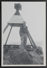
Photograph - Photograph, Black and White, mid 20th C
Appears to have been taken mid 20th C. the trig point is similar to those found around Australia but location yet to be confirmed.Mariner Duncan had a particular regard for the Mission to Seafarers. A plate for display on a commissioned new table at the MTSV acknowledges his bequest and the material donated. Collectively the G W Duncan material includes: photographs, professional data memorabilia and written and commercially printed resources. The memorabilia relates to his career at sea and in particular the role of an engineer, including a handwritten manual of notes and references relating to the mechanical and engineering aspects and areas of responsibility for maintenance. small b & w photograph depicting male figure in casual shirt and trousers standing next to a Trig point on rocks near a coast. ID of figure tbc.trig points, navigation, george winfield duncan (1922-2017), ship engineer, s.s. athenic -
 City of Kingston
Pamphlet - Colour, Smith, Nicolson Pty. Ltd, Cheltenham Estate, c. 1890
Sales plan for land in the suburb of Cheltenham, bounded by Point Nepean Road and Swinden Avenue, including Evesham Road and Wallingford Street.The developing urban area of Cheltenham within the City of Kingston. This land sale pamphlet illustrates the subdivision of land within the municipality and the changing demographic of the district as new houses are constructed close to infrastructure.Colour pamphlet advertising for private sale Cheltenham Estate. Incorporates a map of the estate bordered by Point Nepean Road and Swinden Avenue, including Evesham Road, and Wallingford Street.Handwritten in red ink on subdivison 45: D / H Handwritten in red ink on subdivision 46: Anderson Handwritten in red ink on subdivisions 88, 87, 77 and 56: K / D Handwritten in red ink on subdivision 86: D / H Handwritten in red ink on subdivision 63 and 62: Hudson Handwritten in red ink on subdivision 59 [indecipherable] Handwritten in red ink on subdivision 58: aB Handwritten in red ink on subdivision 57: Lavosh Handwritten in grey pencil on subdivision 28, 26, 24, 67, 58, 49: B Handwritten in grey pencil on subdivisions 78 and 79: Paint Handwritten in purple pencil on subdivsion 114 and 86: B land sales, estate, cheltenham -
 Ballarat Tramway Museum
Slide - 35mm slide/s, Ben Parle, 8/04/1958 12:00:00 AM
Kodachrome Transparency - 35mm slide - cardboard mount, with one side with red border and words "Kodachrome Transparency / Processed by Kodak" top and bottom. Photo taken by Ben Parle 8/4/1958. Has slide No. "6" stamped in black in top corner. Photo of Ballarat No. 20 inbound at View Point Junction, Macarthur St and Wendouree Parade. Has welding truck set up in front of tram. Tram has the destination of Victoria St. See Reg. item 2864 for photo of welding truck. "Drummond St. View Point Jtn Ballarat" / "8-4-58"tramways, trams, view point, macarthur st, wendouree parade, tram 20 -
 Marysville & District Historical Society
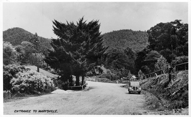
Postcard (item) - Black and white postcard, Valentine Publishing Co. Pty. Ltd, Entrance to Marysville V.11, 1923-1963
A digital copy of an early black and white photograph of the Marysville-Wood's Point Road at the corner with Murchison Street in Marysville in Victoria.A digital copy of an early black and white photograph of the Marysville-Wood's Point Road at the corner with Murchison Street in Marysville in Victoria. This postcard was published by the Valentine Publishing Co. Pty. Ltd. as a souvenir of Marysville.marysville, victoria, postcard, valentine publishing co, souvenir, murchison street, marysville-wood's point road -
 Lakes Entrance Historical Society
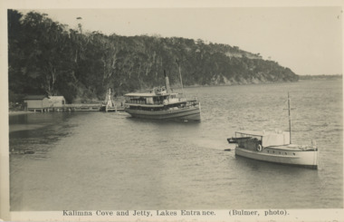
Postcard - S S Gippsland leaving Kalimna Jetty Lakes Entrance, H D Bulmer, 1930 c
S S Gippsland leaving Kalimna Jetty Holdens boat Sagitasse moored nearby Jemmys Point in distance Lakes Entrance VictoriaBlack and white postcard showing S S Gippsland leaving Kalimna Jetty Holdens boat Sagitasse moored nearby Jemmys Point in distance Lakes Entrance VictoriaKalimna Cove and Jetty Lakes Entranceislands, waterways, boats and boating, tourism -
 Glenelg Shire Council Cultural Collection
Photograph - Photograph - Main Breakwater construction, Portland, Oct-54
Port of Portland Authority ArchivesBack: Purple Harbour Trust Stamp. Print No. 4/43 Neg No 273 Date taken 1-10-54 Subject Main Breakwater from Battery Pointport of portland archives, main breakwater, construction, portland harbour, euclid truck, machinery -
 Marysville & District Historical Society
Photograph (item) - Black and white photograph, Rose Stereograph Company, Nichol's Lookout, Marysville, 1913-1967
An early black and white photograph of the view from Nichol's Lookout which is on the Marysville-Wood's Point Road near Marysville, Victoria.An early black and white photograph of the view from Nichol's Lookout which is on the Marysville-Wood's Point Road near Marysville, Victoria. The photograph was also used to produce the Rose Series postcard P. 2324.marysville, victoria, photograph, nichol's lookout, marysville-wood's point road, p. 2324, rose series postcard, souvenir, rose stereograph company, wood's point, mining, yarra track -
Whitehorse Historical Society Inc.
Document, Women's Forum, 2015
Program of a special Remembrance Day Women's Forum.Program of a special Remembrance Day Women's Forum at the Whitehorse Centre on 11 Nov 2015. Rosalie Whalen was a guest speaker whose power point presentation was 'Mary Schwerkolt's story'.,Program of a special Remembrance Day Women's Forum.city of whitehorse, whalen, rosalie -
 Phillip Island and District Historical Society Inc.
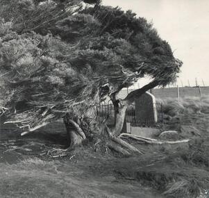
Photograph
One of a collection of over 400 photographs in an album commenced in 1960 and presented to the Phillip Island & Westernport Historical Society by the Shire of Phillip Island. A tragedy occurred at the McHaffie home in 1868. When a friend of John McHaffie, Captain Grossard, was accidentally shot when a fellow guest on the verandah of the homestead mishandled a gun during preparations for a hunt. Captain Grossard's dying wish was that he should be buried on a cliff near the sea. His lonely grave is still to be seen at the end of Grossard Point Road. This inscription appears on the headstone: "Sacred to the memory of William Phillip Grossard, formerly of Bideford, Devonshire, many years captain in the Merchant Service, who was killed by accidental discharge of a gun during a visit to Phillip Island, the 17th December, 1868. A new Headstone has replaced the original one.Photograph of the Lonely Grave and Cypress Tree at Grossard Point.local history, photography, the lonely grave at grossard point, black & white photograph, lonely grave, william grossard, grossard point., john jenner, bryant west -
Glenelg Shire Council Cultural Collection
Photograph - Photograph - Quarry, Pebbly Beach Blacknose Point, 05/11/1952
Port of Portland Authority ArchivesFront: 'PEBBLY BEACH 5..11.52 Looking south from Blacknose Point' Typed on bottom border Back: Purple PHT stamp 15/5 - top left in penport of portland archives -
 City of Kingston
Pamphlet - Black and white, Robert McCamish & John Gilpin (Vendors), For Private Sale Station Entrance Estate, Highett, 1930s
Sales plan for land in the suburb of Highett, bounded by Wickham Road, Railway Parade, Highett Road and Point Nepean Street. The developing urban area of Highett within the City of Kingston. This land sale pamphlet illustrates the subdivision of land within the municipality and the changing demographic of the district as new houses are constructed. The extension of the railway line from the city to Mordialloc opened up the land for development.Black and white pamphlet advertising for private sale the Station Entrance Estate, Highett. Incorporates a map of the estate bordered by Wickham Road, Railway Parade, Highett Road and Point Nepean Road. Handwritten in black ink on reverse: Station Entrance / Estate / Late [indecipherable]highett, land sales, estate -
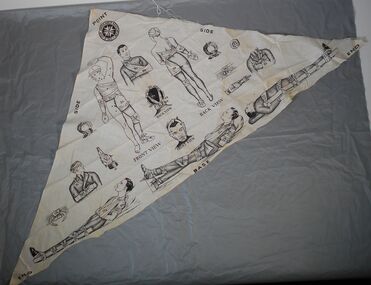 Bendigo Historical Society Inc.
Textile - Triangular bandage
24 June 1883 is recognised as the establishment of St John Ambulance in Australia. St John Ambulance is a community-driven organisation with a 140-year history of providing First Aid in Australia.St John's Ambulance Association triangular fabric bandage with a number of illustrations of entire bodies or faces, showing how this bandage could be used in the event of injuries to various body parts. The fabric is labelled (black capital letters) BASE / ENDX / SIDEx2? POINT and two drawings of face and body read "FRONT VIEW and BACK VIEW. Numerals indicate different bandaging techniques and full figure or partial figure drawings that show how these bandages are applied to injured limbs or torso.Symbol of St John's Ambulance Association in dark black on top point of bandage.first aid, bandage, st john's ambulance -
Glenelg Shire Council Cultural Collection
Photograph - Photograph - Pebbly Beach Quarry, 05/11/1952
Port of Portland Authority ArchivesFront: 'PEBBLY BEACH 5.11.52 Looking south from Blacknose Point' - typed Back: Purple PHT stamp 15/4 crossed out - top left - penport of portland archives -
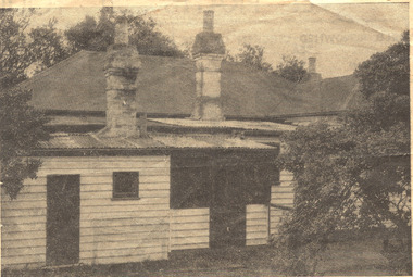 Chelsea & District Historical Society Inc
Photograph - Captain Lonsdale's Cottage, At Carrum
The cottage was built for Captain William Lonsdale (1799-1864), the first Police Magistrate of Melbourne. The cottage was built by the Royal Engineers in Sydney and flat packed to Melbourne in 1837, erected at Jolimont. In 1891 the cottage had to be removed to make way for the Jolimont Railway. It was bought by A. M. Alexander and put up as a beach house in Point Nepean Road (Nepean Highway). In 1959, the cottage was removed from Carrum and was recovered by the National Trust.Newspaper cutting, picture of Captain Lonsdale's Cottage, when it was situated in Point Nepean Road, Carrumcottage, beach house, nepean highway, point nepean road, captain lonsdale, carrum -
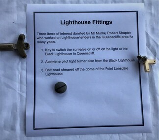 Queenscliffe Maritime Museum
Functional object - Lighthouse fittings
Murray Robert Shapter donated these lighthouse fittings. He was a local fisherman and employee of the Public Works Lighthouse service for many years in the Queenscliff and Point Lonsdale area.Fittings from two lighthouses in the Queenscliff / Point Lonsdale area. Key to switch sunvalve on or off and an acetylene pilot light burner from the light at the Black Lighthouse in Queenscliff, and a bolt head sheared off the dome of the Point Lonsdale Lighthouse.lighthouse maintenance, fittings -
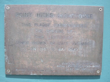 Parks Victoria - Point Hicks Lightstation
Plaque
The rectangular brass plaque commemorates the centenary of the official opening of the Point Hicks Lightstation on 15 May 1890. The engraved text in capitals reads ‘Point Hicks Lightstation/This plaque commemorates/The opening of/This Lighthouse/ (Then known as Cape Everard) /On the 15 May 1890/’. It finishes with the date of 13 May 1990. It is not known whether the plaque is a fixture attached to one of the lightstation buildings, or a detached object. If it is attached, it is defined as building fabric and is included in the Victorian Heritage Register listing for the lightstation. Details of the commemorative ceremony presumably held on 13 May 1990 are not known. It is not known whether the plaque is a fixture attached to one of the lightstation buildings, or a detached object. If it is attached, it is defined as building fabric and is included in the Victorian Heritage Register listing for the lightstation. Brass plaque with an engraved inscription. to commemorate opening of the lighthouse."POINT HICKS LIGHTSTATION/ THIS PLAQUE COMMEMORATES/THE OPENING OF/ THIS LIGHTHOUSE/ (THEN KNOWN AS CAPE EVERARD) / ON THE 15 MAY 1890 / .....13 MAY 1990" -
 Flagstaff Hill Maritime Museum and Village
Decorative object - Wall Hanging, c. 1908
The unusual beautiful green American slate roofing tile used in this wall hanging was recovered from the shipwrecked Falls of Halladale. The iron-hulled, four-masted barque, the Falls of Halladale, was a bulk carrier of general cargo. She left New York in August 1908 on her way to Melbourne and Sydney. In her hold, along with 56,763 tiles of unusual beautiful green American slates (roofing tiles), 5,673 coils of barbed wire, 600 stoves, 500 sewing machines, 6500 gallons of oil, 14400 gallons of benzene, and many other manufactured items, were 117 cases of crockery and glassware. Three months later and close to her destination, a navigational error caused the Falls of Halladale to be wrecked on a reef off the Peterborough headland at 3 am on the morning of the 15th of November, 1908. The captain and 29 crew members all survived, but her valuable cargo was largely lost, despite two salvage attempts in 1908-09 and 1910. ABOUT THE ‘FALLS OF HALLADALE’ (1886 - 1908) Built: in1886 by Russell & Co., Greenock shipyards, River Clyde, Scotland, UK. The company was founded in 1870 (or 1873) as a partnership between Joseph Russell (1834-1917), Anderson Rodger and William Todd Lithgow. During the period 1882-92 Russell & Co., they standardised designs, which sped up their building process so much that they were able to build 271 ships over that time. In 1886 they introduced a 3000 ton class of sailing vessel with auxiliary engines and brace halyard winches. In 1890 they broke the world output record. Owner: Falls Line, Wright, Breakenridge & Co, 111 Union Street, Glasgow, Scotland. Configuration: Four masted sailing ship; iron-hulled barque; iron masts, wire rigging, fore & aft lifting bridges. Size: Length 83.87m x Breadth 12.6m x Depth 7.23m, Gross tonnage 2085 ton Wrecked: the night of 14th November 1908, Curdies Inlet, Peterborough south west Victoria Crew: 29 The Falls of Halladale was a four-masted sailing ship built-in 1886 in Glasgow, Scotland, for the long-distance cargo trade and was mostly used for Pacific grain trade. She was owned by Wright, Breakenridge & Co of Glasgow and was one of several Falls Line ships, all of which were named after waterfalls in Scotland. The lines flag was of red, blue and white vertical stripes. The Falls of Halladale had a sturdy construction built to carry maximum cargo and able to maintain full sail in heavy gales, one of the last of the ‘windjammers’ that sailed the Trade Route. She and her sister ship, the Falls of Garry, were the first ships in the world to include fore and aft lifting bridges. Previous to this, heavily loaded vessels could have heavy seas break along the full length of the deck, causing serious injury or even death to those on deck. The new, raised catwalk-type decking allowed the crew to move above the deck stormy conditions. This idea is still used today on the most modern tankers and cargo vessels and has proved to be an important step forward in the safety of men at sea. On 4th August 1908, with new sails, 29 crew, and 2800 tons of cargo, the Falls of Halladale left New York, bound for Melbourne and Sydney via the Cape of Good Hope. The cargo on board was valued at £35,000 and included 56,763 tiles of American slate roofing tiles (roof slates), 5,673 coils of barbed wire, 600 stoves, 500 sewing machines, 6,500 gallons of oil, 14,400 gallons of benzene, plumbing iron, 117 cases of crockery and glassware and many other manufactured items. The Falls of Halladale had been at sail for 102 days when, at 3 am on the night of 14th November 1908, under full sail in calm seas with a six knots breeze behind and misleading fog along the coast, the great vessel rose upon an ocean swell and settled on top of a submerged reef near Peterborough on south-west Victoria’s coast. The ship was jammed on the rocks and began filling with water. The crew launched the two lifeboats and all 29 crew landed safely on the beach over 4 miles away at the Bay of Islands. The postmistress at Peterborough, who kept a watch for vessels in distress, saw the stranding and sent out an alert to the local people. A rescue party went to the aid of the sailors and the Port Campbell rocket crew was dispatched, but the crew had all managed to reach shore safely by the time help arrived. The ship stayed in full sail on the rocky shelf for nearly two months, attracting hundreds of sightseers who watched her slowly disintegrate until the pounding seas and dynamiting by salvagers finally broke her back, and her remains disappeared back into deeper water. The valuable cargo was largely lost, despite two salvage attempts in 1908-09 and 1910. Further salvage operations were made from 1974-1986, during which time 22,000 slate tiles were recovered with the help of 14 oil drums to float them, plus personal artefacts, ship fittings, reams of paper and other items. The Court of Marine Inquiry in Melbourne ruled that the foundering of the ship was entirely due to Captain David Wood Thomson’s navigational error, not too technical failure of the Clyde-built ship. The shipwreck is a popular site for divers, about 300m offshore and in 3 – 15m of water. Some of the original cargo can be seen at the site, including pieces of roof slate and coils of barbed wire.The Falls of Halladale shipwreck is listed on the Victorian Heritage Register (No. S255). She was one of the last ships to sail the Trade Routes. She is one of the first vessels to have fore and aft lifting bridges. The Falls of Halladale is an example of the remains of an International Cargo Ship and also represents aspects of Victoria’s shipping industry. The wreck is protected as a Historic Shipwreck under the Commonwealth Historic Shipwrecks Act (1976).Wall hanging, framed slate salvaged from the wreck of Falls of Halladale. Slate is visible from both sides of TIMBER frame through glass. Coloured drawing of Falls of Halladale is inserted under glass. Typed inscription " "FALLS OF HALLADALE" "Grounded, Nov 14th, at Wreck Point, Midway between Peterborough & Bay of Islands" Typed inscription " "FALLS OF HALLADALE" "Grounded, Nov 14th, at Wreck Point, Midway between Peterborough & Bay of Islands" falls of halladale, cargo, flagstaff hill, warrnambool, shipwrecked coast, flagstaff hill maritime museum, maritime museum, shipwreck coast, flagstaff hill maritime village, great ocean road, slate, slate tile, green american slates, building material, wreck point, peterborough, bay of islands, russell & co. -
 Lara RSL Sub Branch
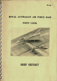
Booklet, Royal Australian Air Force Base Point Cook, May 1969
The booklet gives a brief history of RAAF Base POINT COOK from the inauguration of the Base in 1913, until May 1969History of the Royal Australian Air Force Base Point CookSpiral bound booklet giving a brief history of the RAAF Base Point Cook. White spiral bound with cream covered cardboard front and back covers. Three pages of typed historic information nilraaf, point cook, history of point cook, raaf museum, sir richard williams, captain t.w. white, lt g.p. merz, central flying school point cook, australian air corps, raaf academy -
 Marysville & District Historical Society
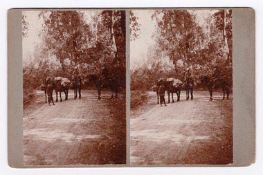
Photograph (Item) - Black and white bi-focal image, Unknown
An early black and white bi-focal image of men and packhorses on the Marysville-Wood's Point Road in Marysville in Victoria.An early black and white bi-focal image of men and packhorses on the Marysville-Wood's Point Road in Marysville in Victoria. This is now known as the Marysville-Wood's Point Road. The Marysville-Woods Point Road was originally part of the Yarra Track, constructed in the early 1860s to provide access between Healesville and the Woods Point Goldfields. Despite the steep terrain and engineering difficulties, the Yarra Track soon became a busy route used by pack horses, horse-drawn drays, and wagons. Today this sealed mountain road is a popular scenic drive between Marysville and Warburton.Packhorses on Wood'spoint Road/ Marysville/ Victoriapackhorses, wood's point road, marysville-wood's point road, marysville, victoria, yarra track, healesville, wood's point goldfields, warburton -
 Ballarat Tramway Museum
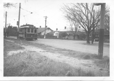
Photograph - Digital image, Wal Jack, 13/07/1944 12:00:00 AM
Yields information about the intersection of MacArthur St. and Wendouree Parade, View Point in 1944.Digital image from the Wal Jack Ballarat Album of a photograph of No 33 in Wendouree Parade and No. 21 in Macarthur St, View Point, 13-7-1944. Photo Wal Jack. No. 33 has the destination of View Point. See image i2 for rear of photograph. See image i3 for hi res scan of print. See image i4 for hi res scan of negativeOn rear of photograph in ink "SEC, No. 33 at View Point terminus in Wendouree Parade, No. 21 in Macarthur St, Ballarat 13-7-44" and in top right hand corner, Wal Jack stamp with "T62" written in.trams, tramways, view point, macarthur st, wendouree parade, tram 33, tram 21 -
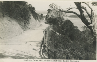 Lakes Entrance Historical Society
Postcard - Princes Highway Lakes Entrance, 1930 c
Princes Highway Jemmys Point showing gravel road post and rail fence freshly excavated cliff with Entrance glimpses in distance Lakes Entrance Victoria. Also a second black and white postcard taken much later of Princes Highway Jemmys Point Lakes Entrance showing sealed road with double lines in centre, post and rail fence, Entrance in distance. Donor Susan Samuel 2 January 2015. Number 04204.1Black and white postcard taken of Princes Highway Jemmys Point showing gravel road post and rail fence freshly excavated cliff with Entrance glimpses in distance Lakes Entrance VictoriaLooking Down the Princes Highway Lakes Entrancecivil engineering, roads and streets, fences -
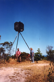 Lakes Entrance Historical Society
Photograph - Lakes Entrance Grid location, 1999
Lakes Entrance Grid reference, Cunninghame 8522.3.4 896.082, on ten acre site with trig point, it is from this point that all the survey for the surrounding areas was undertaken. Part of the Vic Geodetic Survey initiated in 1860 by Ellery Survey started from triangulation base in Werribee. (Grid ref B'dale 8422)Colour photograph of the Victoria Geodetic Survey Triangulation Station, Trig Station, situated off Ocean View Parade, Merrangbaur Hill. Location is indicated by ground point and standing structure, situated on an elevated bush block. Lakes Entrance Victoriasurveying, township planning -
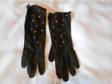 Bendigo Historical Society Inc.
Clothing - MAGGIE BARBER COLLECTION: BRACELET LENGTH BLACK SUEDE GLOVES EMBROIDERED, Late 1800's
Clothing. Black suede bracelet length gloves, embroidered with floral motifs in the Beauvais style of embroidery, and as stated inside the right glove, ''REAL BEAUVAIS POINT HAND MADE 927 6/14. Embroidery made with a hook. Fifteen tiny flowers in shades of blue, pink, red, green, are scattered across the top of the gloves.REAL BEAUVAIS POINT, HAND MADE 927 61/4 RIGHT GLOVE. MADE IN FRANCE 927,Left glove.costume accessories, female, bracelet length black suede gloves, beauvais is a french term for a form of tambour embroidery, which is decorative needlework technique using a hook. -
 City of Kingston
Pamphlet - Colour, Stillwell and Co, The Hill Estate, Highett, 1917
Sales plan for land in the suburb of Highett, bounded by Point Nepean Road and including Sandford Street, Turner Road, Alfred Street and Peace Street.The developing urban area of Highett within the City of Kingston. This land sale pamphlet illustrates the subdivision of land within the municipality and the changing demographic of the district as new houses are constructed close to infrastructure.Colour pamphlet advertising for sale at auction The Hill Estate, Highett. Incorporates a map of the estate bordered by Point Nepean Road and including Sandford Street, Turner Road, Alfred Street and Peace Street.Handwritten in grey pencil on subdivision map next to subdivisions 91, 92, 93, 106, 107 and 108: x Handwritten in grey pencil on back cover: The / Hill Estate / Highettland sales, estate, highett -
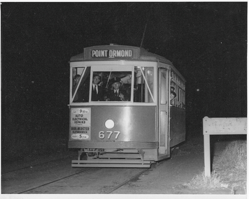 Melbourne Tram Museum
Photograph - X2 677 Point Ormond Last Car, Jim Seletto, 22 October 1960
The photograph shows X2 class tram No. 677 with the destination of Point Ormond at the western end of Glen Huntly Rd at that location. Dark exterior becasue this was 10.30pm in parkland. This was the last car before the line closed to revenue service. Photo by Jim Seletto 22 October 1960Yields information about MMTB X2 and Point Ormond terminus.Black and white photograph with photographer's notes on rear In pencil on rear: 'Last car ex Point Ormond, 10.30pm Oct 22 60. Photo J Seletto JSE10'trams, point ormond, glen huntly rd, tram 677, x2 class, trramways -
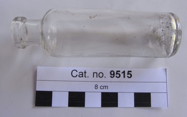 Coal Creek Community Park & Museum
Bottle, glass, 1916-1923
Cylindrical clear glass bottle with text embossed on base'AGM' with point on 'A' -
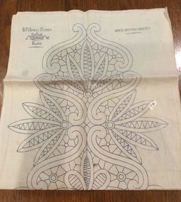 Mont De Lancey
Embroidery pattern
Calico embroidery pattern for table runner, intended for Renaissance work, or Point Lace. The blue printed pattern depicts leaves and flowers the whole length of the runner." L.B. Lacet Runner. J.W. with a crown in between the two letters, No. 4322" in top left hand corner of the runner and "Worked with Point Braid No. 261" in the top right hande corner. The same inscriptions are found repeated at the other end of the runner.household textiles., tableware, textileworking patterns