Showing 2474 items
matching townships
-
 Whitehorse Historical Society Inc.
Article, Blackburn : a model township, 1889
Description of Blackburn as a model township including a lake, ravine etc.Description of Blackburn as a model township including a lake, ravine etc.Description of Blackburn as a model township including a lake, ravine etc.blackburn model township, blackburn lake -
 Ballarat Heritage Services
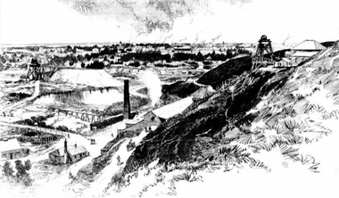
Photograph - Image - Black and White, Ballarat From Black Hill, 1888, 1888
Image of a mining site on Black Hill, with the township of Ballarat in the background. black hill, mining, poppett head, black hill flat -
 Queenscliffe Maritime Museum
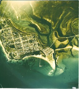
Photograph - Arial colour photograph of Queenscliffe & environs, Arial photo of Queenscliffe c1950, c1950
Queenscliffe area historyQueenscliffe from the air c1950Queenscliffe & environs, piers & township arial colour picture, c1950Reverse " present from / (North Arm was removed ? / see Mike Bailey "queenscliffe township -
Stawell Historical Society Inc
Map, Parish of Stawell, County of Borung, Stawell Township, Sheet 1, 1879
Parish of Stawell, County of Borung, Stawell Township, Sheet 1stawell -
 Tarnagulla History Archive
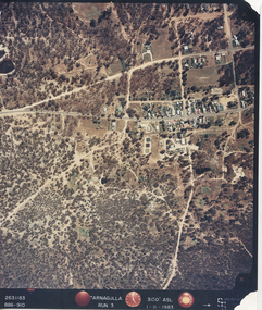
Photograph: Aerial view of Tarnagulla, 11th November 1983
Donald Clark Collection. An aerial colour photograph of Tarnagulla township. Labelled Run 3.tarnagulla -
 Falls Creek Historical Society
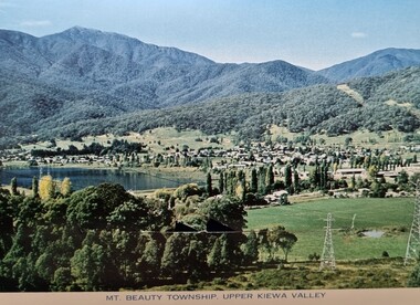
Postcard - Mount Beauty Township
These photographs were taken in and around Mount Beauty and the Kiewa Valley by Samuel Keith Pearce and printed for him as a foldout postcard by NuColor Vue. The postcards state they were printed for S. K. Pearce Pty. Ltd of Tawonga and Mount Beauty. Samuel Keith Pearce was born on 24 June 1917 in Armadale, Victoria. By the late 1940s he owned the Mt Beauty Supermarket, Newsagency, Drapery and Hardware store at Mount Beauty and also a store at Tawonga in partnership with his brother Gordon Cathew Pearce. For some time, they operated as Pearce Brothers. In the early 1960s Keith also opened a mini mart In Falls Creek. As well as being a keen photographer and an astute businessman, Keith Pearce was a well-known identity in the Kiewa Valley, making many contributions to the development of the area over a long period. This included serving as a member of the Bright Shire Council for many years. He worked hard to promote the interests of the Upper Kiewa Valley. As a sign of recognition and appreciation for his contribution to the community, the park opposite the grocery store in Mount Beauty was named the SK Pearce Gardens in his honour. Samuel Keith Pearce died on 7 July 1994 in Mount Beauty, Victoria Mount Beauty was originally established by the State Electricity Commission of Victoria to house construction workers from the Kiewa Hydroelectric Scheme in 1949,[2] passing to the control of the local shire council in 1967 after construction was completed. The town is a launching point for trips to the Falls Creek ski resort, and to the Bogong High Plains. This collection of postcards and images is significant because they were commissioned by a highly successful businessman in Falls Creek, Victoria.A colour image of the township of Mount Beauty in the Upper Kiewa Valley.mt. beauty, kiewa hydroelectric scheme, falls creek, bogong high plains -
 Bendigo Historical Society Inc.
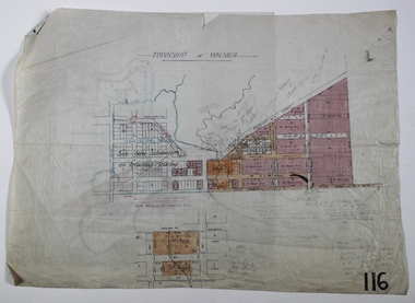
Map - WALMER, Circa 1900
Map: Township of Walmer, 2 hand Draughted Parish plansmap, township, walmer -
 Bacchus Marsh & District Historical Society
Map, Plan of the second portion of the property of Messers Atkins and Clarke situate at Bacchus Marsh 1856
This plan of land allotments for sale indicates part of the property once owned by the Bacchus family in and around the township area of Bacchus Marsh. The Bacchus family sold their property in Bacchus Marsh to John Aitkins and Robert Nalder Clarke in March 1851. Aitkins and Clarke kept the property for a number of years until April 1856 when these allotments were put up for sale.This is a very early land sales plan for agricultural land close to the township of Bacchus Marsh. It therefore provides some clues as to how the early urban development of the township and agricultural development of the nearby area took place. Upon seeing the map in 1911 Bacchus Marsh Express newspaper editor Christopher Crisp wrote "The sale appears to have created the present township, which had a nucleus in earlier times further east", Express, 30 September, 1911, page 3.A single page paper plan showing allotments of land for sale. The subdivided land shown was owned by John Aitkins and Robert Nalder Clarke, but previously owned by the Bacchus Family and was in and around their Manor House (Mansion) property in Bacchus Marsh. This plan shows allotments in the second portion of land to be sold which was located east of the Manor House on the eastern side of the Lerderderg River. The land for sale was made up of 15 allotments. The plan is pasted into a bound volume containing 76 maps or plans in total. BMDHS Loc: AR/B12/S4 Bacchus Marsh Township and Nearby Districts Maps Volume In-house Digital copies: BMDHS, Computer Network: Maps\Bacchus Marsh Township and Nearby Districts Maps Volumebacchus marsh victoria maps, bacchus family, land sales, manor house bacchus marsh -
 Bacchus Marsh & District Historical Society
Map, 'Map of Darley' circa 1877-1897
This map shows the early laid out streets and roads for the village of Darley and the main roads and streets in the central area of the township of Bacchus Marsh. The date of the map is not known. Landmarks indicated on the map including the Anglican Church in Church Street (Gisborne Road), opposite the Presbyterian Church, and the Baptist Church at its pre-1898 Main Street location suggest the map is dated between 1877 and 1897. Landholders names can be seen on some of the allotments of land marked in this map, including the names Clifton, Cosgrove, O'Hagan, McFarlane, Nagle, O'Hagan, Simpson and Vallence.A single page paper map showing the village of Darley and the township of Bacchus Marsh. Scale 10 chains to 1 inch. The map is pasted into a bound volume containing 76 maps or plans in total. High resolution digital image stored on BMDHS computer network. darley victoria maps, bacchus marsh victoria maps -
 Ringwood and District Historical Society
Flyer, Land Sale Advertisement - East Ringwood Township Estates, East Ringwood, Victoria - circa 1920
The date of the flyer as circa 1920 can be estimated from the references to the (decision on) "electrification of the Croydon Railway Line" which eventually occurred in 1923, letting of tenders for the state school building which opened in 1924, and the "proposed new railway station" (East Ringwood) which opened in 1925, Advertisement for three retail and residential allotment land sales in East Ringwood Township including maps showing layout of subdivisions. Township Estate, State School Estate, and East Ringwood Station Estate.Subdivision plans include Mount Dandenong Road, Grey Street, Eastfield Road, King Street, Everard Road, Holland Road, Purser Avenue, and Charles Street. (Agents) Spencer Jackson, Subdivider & Homebuilder, 341 Collins Street, Melbourne, Phones: M2327 (3 lines), also at Dromana, Phone 65. -
Lakes Entrance Historical Society
Book, Gippsland Lakes Use Strategy Plan Background Report, 1978
... Townships ...Background report from Planning Board 1978Paperback with 125 pagestownships, planning committee -
 Lakes Entrance Historical Society
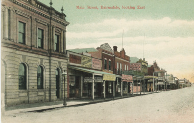
Postcard - Main Street Bairnsdale, 1895 c
... Townships ...Eastwood Brothers shown in image beside the Savings BankTinted postcard looking east of businesses on the north side of Main Street Bairnsdale Victoriatownships, businesses -
 Lakes Entrance Historical Society
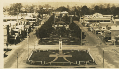
Postcard - Main Street Bairnsdale, Bulmer, 1920 to 1930 c
... Townships ...Black and white postcard showing Main Street Bairnsdale taken from the water tower Bairnsdale VictoriaMain Street Reserves Bairnsdaletownships, roads and streets -
 Bendigo Historical Society Inc.
Map - JACK FLYNN COLLECTION: TOWNSHIP OF STANHOPE, December 1950
Map: Township of Stanhope, Parish of Girgarre, County of Rodney. Parish plan.By Authority J. J. Gourley, Government Printer, Melbourne. Drawn and Reproduced at the Dept, of Lands and Survey, Melbourne, Victoria.map, rodney, township, stanhope -
 Bendigo Historical Society Inc.
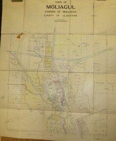
Map - JACK FLYNN COLLECTION: MOLIAGUL, 7/02/1931
Map: Township of Moliagul, Parish of Moliagul, County of Gladstone. Parish plan.map, gladstone, township, moliagul -
 Bendigo Historical Society Inc.
Map - JACK FLYNN COLLECTION: GIRGARRE, 1957
Map: Township of Girgarre, Parish of Kyabram, County of Rodney. Parish plan.By Authority: W. M. Houston, Government Printer, Melbourne. Drawn and reproduced at the Department of Lands and Survey, Melbourne.map, rodney, township, girgarre -
 Bendigo Historical Society Inc.
Map - JACK FLYNN COLLECTION: GOORNONG, August 1953
Map: Township of Goornong, Parish of Goornong, County of Bendigo. Parish plan.By Authority W.M. Houston. Government Printer. Drawn and Reproduced at the Dept., of Lands and Survey, Melbourne, Victoria. August 1953map, bendigo, township, goornong -
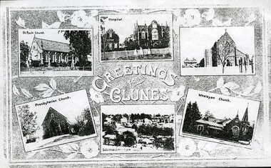 Clunes Museum
Photograph, UNKNOWN
.1 .2 PHOTO COPY OF A POSTCARD OF THE CHURCHES, HOSPITAL AND TOWNSHIP OF CLUNESGREETINGS FROM CLUNESlocal history, photography, photographs, churches, hospital and township -
Lakes Entrance Historical Society
Book, Rule Hilda, Back to Nowa Nowa, 1980
A short history of the timber township of Nowa Nowa, East Gippsland Victoria.township, settlers, timber industry, schools, transport -
Lakes Entrance Historical Society
Book, Bundalaguah Centenary Committee, Back to Bundalaguah, 1972
A souvenir booklet produced for the centenary of the Parish and township of Bundalaguah Gippsland Victoriatownship, settlers, agriculture, education -
 Bendigo Historical Society Inc.
Map - MANDURANG, No date visible
Map: It has the Village of Mandurang on one side and the Township of Laanecoorie on the reversemap, bendigo, parish plan, mandurang, laanecoorie -
Clunes Museum
Plan - TITLE PLAN, DEPARTMENT OF LANDS AND SURVEY, TOWNSHIP OF GLENGOWER
1 PAGE PLAN OF THE TOWNSHIP OF GLENGOWER COUNTY OF TALBOT (11 COPIES) DRAWN AND REPRODUCED AT THE DEPT. OF LANDS AND SURVERY MELBOURNE VICTORIA NOVEMBER 1954 PRICE 2/-parish of glengower, title plan of glengower -
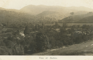 Lakes Entrance Historical Society
Postcard, H D Bulmer, Little River Falls , Wulgulmerang near Buchan Victoria, 1915 c
Black and white postcard of the countryside and hills surrounding township of Buchan VictoriaView of Buchanagriculture, topography -
 Ringwood and District Historical Society
Map - State Aerial Survey, Dandenong Ranges Area Sheet 7, Parishes of Warrandyte, Scoresby, Ringwood and Nunawading - 1956
Map of central and southern areas of Ringwood and part of Ringwood East and Heathmont compiled by Dept of Lands and Survey, July 1956, from aerial photographs and Cadastral Survey information. Subsequent coloured hand-drawn additions showing layout of a number of post-NSW Separation era proposed subdivisions that did not eventuate, including Village of Studley Estate, Township of East Kew Estate, Township of Ballyduffy Estate, Township of New Flemington Estate, Township of East Hawthorne Estate. Ringwood A4B2, 849 A4B Zone 7. Scale: 10 chains to 1 inch. Contour interval 20 feet. -
Bendigo Historical Society Inc.
Map - TARNAGULLA : COUNTY OF BENDIGO, 13-5-22
Map. County of Bendigo, County of Gladstone.Inglewood, Glenalbyn, Kingower, Moliagul, Waanyarra, Laaneoorie, Woodstock, Loddon River, Township of Tarnagulla, Township of Newbridge, Township of Llanelly, Dunolly to Inglewood Railway, Tarnagulla Rifle Range, Laurie Station, Bullabul Creek, Arnold Township, Arnold Railway Station. Photo-Lithographed at the Department of Lands and Survey, Melbourne by W.J. Butson, 13-5-22.Price 1/-.By authority A.J. Mullett, Government Printer, Melbourne. (number 118 in map cupboard 1)A.J. Mullett, Government Printer, Melbourne.map, bendigo, tarnagulla -
Clunes Museum
Album - PHOTO ALBUM
Photo album prepared for application in 1990 "Tidy Town" CompetitionExample of community pride and co-operationLeather look photo album, embossed, gold lettering, containing photos, descriptions, and itinerary of judge of competitionEntry of Clunes township in tidy town competition 1990 (inside front cover)photo album, tidy town competition -
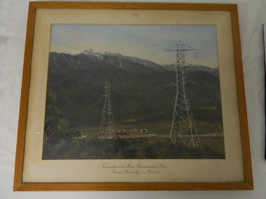 Kiewa Valley Historical Society
Framed photo - Mt Beauty Township & Main Transmission Line, 1954
This is a photo of Mount Beauty taken from a high vantage point near the hair-pin bend on the Tawonga Gap Road (half way up) in 1954. Mount Beauty was built by the State Electricity Commission of Victoria during the construction of the Kiewa Hydro Electric Scheme.This photo belonged to Mr & Mrs Gordon White SECV employee and long time residents of Mt Beauty.This is a framed coloured photo of the Mount Beauty Township and main Transmission Line from Mt Beauty to Kiewa. The photo has two transmission lines in the foreground with the Mt Beauty township in the background, but at the foot of Mount Bogong.Approx 1954 / Conroy-Moffatt Pty Ltd / Picture Framer / ..McKillop Street / Tel Mu .. 78 ....mt beauty; transmission line; tawonga gap road; kiewa hydro electric scheme -
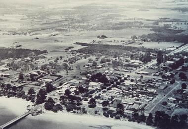 Phillip Island and District Historical Society Inc.
Photograph, 1940's 1950's
Photograph donated by John JanssonBlack & White aerial view of the Cowes Township and jetty area, Phillip Islandcowes phillip island, aerial view of cowes, cowes jetty, cowes pier phillip island, john jansson -
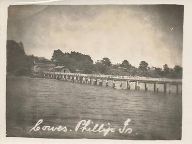 Phillip Island and District Historical Society Inc.
Photograph, Early 20th Century
One of a collection of 8 photographs donated by Bob Notley of San RemoBlack & White photograph of the Cowes Pier looking towards sheds and Cowes Township.Cowes, Phillip Is.cowes pier, cowes jetty, bob notley -
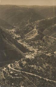 Phillip Island and District Historical Society Inc.
Photograph - Post Card, Late 19th Century
Photograph donated by Jean ArchibaldBlack & White Photograph of the road winding through the hills of Walhalla township, VictoriaFront: "Walhalla 43" Back: "To M with love from G W" "write soon"walhalla victoria, jean archibald, mining town