Showing 18088 items matching "view-master"
-
 Federation University Historical Collection
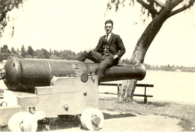
Photograph, Vernon Holt, Frank Wright on the Canon at View Point, Lake Wendouree, 3/2/1922
Frank Wright was a renown resident of Smeaton, where he was born. He lived at Laura Villa, and attended Smeaton State School. His father William was a gold miner and his mother's name was Sarah. Their family won many singing and instrumental awards. Frank was tutored by Percy Code and was awarded a gold medal for the highest marks in the ALCM examinations in the British Colonies at the age of seventeen years. He became the Australian Open Cornet Champion by the age of eighteen. A year later, Frank conducted the City of Ballarat Band, and later the Ballarat Soldiers’ Memorial Band. He formed the Frank Wright Frisco Band and Frank Wright and his Coliseum Orchestra. These bands won many South Street awards, and Frank as conductor won many awards in the Australian Band Championship contest. In 1933 Frank Wright sailed to England to conduct the famous St Hilda’s Band and was later appointed Musical Director of the London County Council, where he organized many amazing concerts in parks, in and around the London district. He was made Professor of Brass and Military Band Scoring and conducted at the Guildhall of Music and Drama. Frank was often invited to adjudicate Brass Band Championships around Europe, in Australia, including South Street and in New Zealand. The Frank Wright Medal at the Royal South Street competition is awarded to an individual recognized as making an outstanding contribution to brass music in Australia.Black and white photograph of a man dressed in a three piece suit sitting on a canon which is located in a park overlooking a lake. Trees and houses can be seen on the other side of the lake. The man is Frank Wright and the place is "View Point", Lake Wendouree, Ballarat.Written in pen on back - Frank Wright - on canon at "View Point", Lake Wendouree, Ballarat. Photo by Vernon Holt 3/2/22frank wright, vernon holt, lake wendouree, ballarat, canon -
 Whitehorse Historical Society Inc.
Article, Valley view lost with ten day's notice, 2007
Residents in Irene Crescent Mitcham were angry that only 10 day's notice was given by Whitehorse Council prior to work starting on the implement shed at the Schwerkolt Cottage site.Residents in Irene Crescent Mitcham were angry that only 10 day's notice was given by Whitehorse Council prior to work starting on the implement shed at the Schwerkolt Cottage site. Resident Debbie Willenberg (photo) will have view restrictedResidents in Irene Crescent Mitcham were angry that only 10 day's notice was given by Whitehorse Council prior to work starting on the implement shed at the Schwerkolt Cottage site.schwerkolt cottage & museum complex, willenberg, debbie, irene crescent, mitcham, wilkinson, terry, city of whitehorse -
 Ballarat Heritage Services
Photograph - Colour, Clare Gervasoni, 'Coolock', Bendigo, 2011, 17/03/2014
Colour photograph of a building in View Street Bendigo.coolock, bendigo -
 Mt Dandenong & District Historical Society Inc.
Photograph, View From Seat of Jeeves Coach, c1921
View the driver would have from horse drawn coach. CRB (Main) Road between Wombat Road and Falls Road. c1921. This photograph has a detailed inscription on the back handwritten by John Lundy-Clarke in 1974.View from seat of Jeeves Coach over horses while being driven along the new CRB road between Wombat Road and Falls Rd 1921.wombat road, falls road, crb road, jeeves coach, horse -
Federation University Historical Collection
Document - Document - Letter, Ballarat Junior Technical School: Letter from Mr Robert Watson, Head Master re Appointment of a teacher-librarian, and letter of approval, 1961
Letter from Robert Watson, Head Master of Ballarat Junior Technical School requesting a teacher-librarian be appointed to replace teacher who is working in that area plus other subjects. Teacher he has in mind is Mrs Lockhart who is attached to the School of Mines staff as library assistant. A letter from Mr Watts of the Technical Inspectors to Mr Arblaster, Principal of SMB states the need for a teacher-librarian, Mrs Lockhart, be appointed to BJTS. 3 white pages,typedballarat junior technical school, head master, robert watson, teacher-librarian, mrs lockhart, technical inspectors, mr watts, mr arblaster, school of mines -
Stawell Historical Society Inc
Map, Crocodile Gold Corp, Photographic Aerial View of Big Hill showing underground workings and surface workings and proposed Big Hill Open Pit proposal, December 2014
Crocodile Gold Corp SGM photo Map showing Magdala Decline& Wonga Decline December 2014 Produced for Public Consultation over Big Hill Open Pit Proposal. Aerial Views Stawellmining, gold, map -
University of Melbourne, Burnley Campus Archives
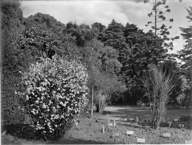
Photograph - Black and white print, 23. View of Pond
Labelled, "View of Pond."pond, mrs. jessep, alexander william jessep, principal, a.w. jessep -
University of Melbourne, Burnley Campus Archives
Photograph - Black and white print, 26. View of Pinus
Labelled, "View of Pinus."trees, mrs. jessep, alexander william jessep, principal, a.w. jessep -
University of Melbourne, Burnley Campus Archives
Photograph - Black and white print, 31. View of Frames
Labelled, "View of Frames."frames, mrs. jessep, alexander william jessep, principal, a.w. jessep -
 St Kilda Historical Society
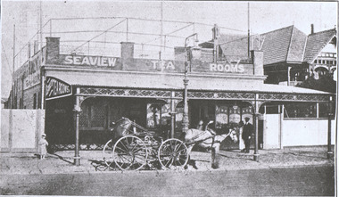
Photograph, Sea View Tea and Refreshment Room, Marine Parade, St Kilda c1915, c. 1915
Sea View Tea and Refreshment Rooms, Marine Parade (below Brook's Boat Sheds). Mrs Blyth (late of Bendigo) Proprietress. I.X.L. Ice Cream. Roof promenade for Afternoon Tea and Summer Drinks. black and white photograph fair condition unmountedSea View Tea and Refreshment Rooms, Marine Parade (below Brook's Boat Sheds). Mrs Blyth (late of Bendigo) Proprietress. Tel. 1478 w. I.X.L. Ice Cream. Roof promenade for Afternoon Tea and Summer Drinks. K42 Sea View. p.64 St Kilda by the Sea Annual 1915-16 Season F600.65. NationalLibraryof Australia, Canberra. -
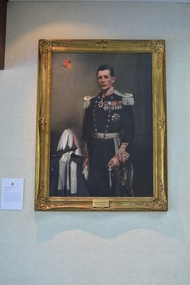 Freemasons Victoria - United Grand Lodge of Victoria
Painting, MWBro. Lord Somers D.C.M.G., D.S.O.M.C. Grand Master 1927-1932, 1930s
The right honourable Lieutenant-Colonel Arthur Tennyson Somers Cocks, was born in Herefordshire. Served with distinction in the Army and was twice decorated with bravery, before being appointed as Governor of Victoria. This portrait of Lord Somers is the only one in which a Grand Master is not in masonic regalia. Lord Somers insisted he not be seen dressed in a manner which could give offence to any other organization, with which he was associated in Public Life or Private Life. He was deeply involved in the Scouting Movement and was Chief Scout in Victoria and succeeded Baden-Powell as Chief Scout of the British Commonwealth.The portrait of Lord Somers holds great significance as it is the only painting within the Library and Museum collection of a Grand Master without his masonic regalia. Lord Somers stands beside his hat and is in uniform, no apron or other freemason regalia. Freemason Victoria coat of arms in upper left corner.Framed oil painting on canvas with stretcher/strainer. Wood/metal composite brackets used to fix painting to wall. 'Compo' ornamented gilt frame with running designs. Metal placque with two screws holding it to frame. portrait, painting, freemasons victoria, freemasonry, victoria, grand master -
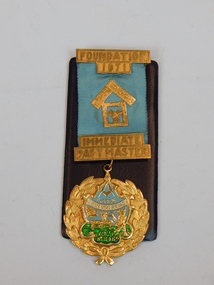 Freemasons Victoria - Dandenong Lodge No. 635
jewel, past masters jewel, 1972
Presented to the lodge by A C Downard to be presented to the IPM on 12/12/73 lodge masters jewelfoundation 1971 immediate past master- lodge Eumemmerring 846 presented to Wor. Bro. A. C. Downard foundation master 13 / 12 / 1972 -
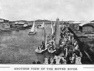 Port Fairy Historical Society Museum and Archives
Photograph - Souvenir folder, Another View of the Moyne River
This photograph probably taken during Terang day. The people of Terang used to come to Port Fairy by train for the day and lots of events were put on for the people to take part in. Boating, swimming, picnicing in the botanical gardens, foot races, cricket etc.black and white photograph of the Moyne river showing a crowd of tourists possibly on Terang day as they alighted from the train that has pulled onto the wharfAnother view of the Moyne riversouvenir, port-fairy, terang day, train, wharf, moyne river, boats, crowd, people -
University of Melbourne, Burnley Campus Archives
Photograph - Black and white print, 58. View of oak Tree
Labelled, "View of Oak Tree."oak tree, mrs. jessep, alexander william jessep, principal, a.w. jessep -
 University of Melbourne, Burnley Campus Archives
Photograph - Colour print, Burnley Campus Archives, The Same View 1997, 1997
Appears to be used for an exhibition.Colour photograph pasted on polystyrene board for an exhibition. Administration Building in Autumn. Magnolia grandiflora, Birch trees and MelaleucaCaption, "The Same View 1997."administration building, magnolia grandiflora, birch trees, melaleuca styphelioides, autumn -
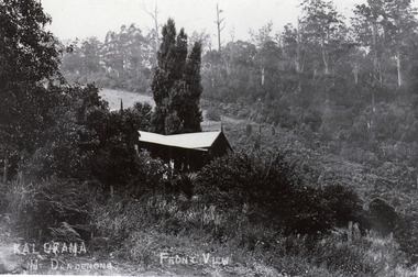
 Mt Dandenong & District Historical Society Inc.
Photograph, View Up Valley At Kalorama
John Lundy-Clarke grew up in the Kalorama/Mt Dandenong area and later in life (1972-74) began to write a comprehensive history of the area working from an original settlement map in an effort to cover all areas. The building in the centre of the photograph is 'Kia-Ora' guest house. Situated on Barber’s Road, ‘Kia-Ora’ was built in 1912 by George Barber. It was later leased by a Mrs Pemberthy. “Kia-Ora’ was one of four places connected when the telephone was brought into the district in 1912. The other places were ‘Mountjoy’, ‘Cherry Farm’ and ‘Callum House’. ‘Kia-Ora’ was burnt down in 1924. Black and White copy of section of a Rose Series postcard. Shows view up the valley at Kalorama with a decorative building centre middle of photograph. Handwritten description by John Lundy-Clarke on reverse.View up valley at Kalorama from near junction of Barbers and Doughty’s Rds. “Kia Ora” guest house in centre. Paynter’s “Iona” top left with “Kalorama” to its right. About 1912. Rose Series copied by JLC 1973.kalorama, kalorama valley, john lundy-clarke, barbers road, george barber, kia-ora, guest house, iona -
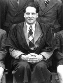 Mentone Grammar School
Karl Duldig, Art Master (1945-1967)
In 1945, after feeling Nazi Germany in 1939, Karl Duldig and his wife, Slawa, were finally granted ‘landing permits’ in Australia, after six years living in refugee camps, both here and Singapore. Duldig was appointed art master at Mentone Grammar in 1945, while also establishing a small ceramics business with his artist-inventor wife, Slawa. His work was prolific across several mediums. Our School Archives holds a large collection of sketches, as well as several bronze busts which he made, depicting life, students, and staff at Mentone Grammar during his time at the School from 1945 to 1967. -
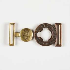 City of Greater Bendigo - Civic Collection
Uniform - Buckle from Telegram Satchel Belt, Post Master General's Department et al
Electrical telegraphs were point to point text messaging systems primarily used from the 1840's until the late 20th century. It was the first electrical telecommunications system and were sent by an operator or telegrapher using Morse code. Social telegrams were also encouraged and special pictorial forms and envelopes were designed such as the special purple form and envelope which was used when conveying condolence details during World War 2.(fn. Powerhouse https://collection.powerhouse.com.au/object/163103). There was a brief resurgence in telegraphy during World War I but the decline continued as the world entered the Great Depression years of the 1930s. Although telegraph lines continued to play an important part in distributing news feeds from news agencies post World War 2, the rise of the internet in the 1990s and the widespread installation of the telephones in homes saw the need for telegrams to greatly decline. When the Commonwealth Post and Telegraph Act was passed in June 1902, and a national Postmaster General's Department (the PMG) was established the responsibility for the nation's mail and telephone services fell on Post Offices. The Bendigo Post Office, built in 1887 and situated on Pall Mall was the central distribution centre for receiving and delivering telegrams and continued to deliver communication and postal services until 1997. Now a Visitor Centre, dedicated volunteers at the Post Office continued to demonstrate and educate the public about telegraphic services and the development of this unique form of communication up until 2019 when Covid 19 disrupted every day life, coupled with the death Ted Rankins (the last Post Master and a long term telegraph volunteer at the Post Office). This belt buckle was used on the leather satchels used by Junior Postal Workers in Bendigo to carry telegrams which were delivered by bicycle in the early years. The buckle is part of the postal collection donated by the Rankins family in memory of Ted Rankins.Circular belt buckle from telegram delivery satchel belt. Inner buckle depicts the Greek deity Hermes who personifies the transmission of information and was adopted as an allegorical representation of the function of postal services. Outer buckle; Post Office / Communications / Australia. Centre top outer buckle; emu, kangaroo and shield Inner buckle; Hermes (left facing)bendigo post office, bendigo tourism, city of greater bendigo tourism, post office collection, ted rankins collection -
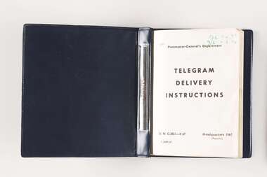 City of Greater Bendigo - Civic Collection
Manual, Post Master General's Department, Telegram Delivery Instructions, 1967
Electrical telegraphs were point to point text messaging systems primarily used from the 1840's until the late 20th century. It was the first electrical telecommunications system and were sent by an operator or telegrapher using Morse code. Social telegrams were also encouraged and special pictorial forms and envelopes were designed such as the special purple form and envelope which was used when conveying condolence details during World War 2.(fn. Powerhouse https://collection.powerhouse.com.au/object/163103). There was a brief resurgence in telegraphy during World War I but the decline continued as the world entered the Great Depression years of the 1930s. Although telegraph lines continued to play an important part in distributing news feeds from news agencies post World War 2, the rise of the internet in the 1990s and the widespread installation of the telephones in homes saw the need for telegrams to greatly decline. When the Commonwealth Post and Telegraph Act was passed in June 1902, and a national Postmaster General's Department (the PMG) was established the responsibility for the nation's mail and telephone services fell on Post Offices. The Bendigo Post Office, built in 1887 and situated on Pall Mall was the central distribution centre for receiving and delivering telegrams and continued to deliver communication and postal services until 1997. Now a Visitor Centre, dedicated volunteers at the Post Office continued to demonstrate and educate the public about telegraphic services and the development of this unique form of communication up until 2019 when Covid 19 disrupted every day life, coupled with the death Ted Rankins (the last Post Master and a long term telegraph volunteer at the Post Office). This book was issued to Junior Postal Workers in Bendigo to guide them in the delivery of telegrams and designed to fit into their delivery satchels and carried while on the job. In the early years telegrams were delivered by bicycle and this manual is part of the postal collection donated by the Rankins family in memory of Ted. Small, blue, vinyl covered manual. Contains thirty printed pages covering all aspects of how to correctly deliver telegrams. Topics include 'Loss of telegram', 'Undelivered Telegram', 'special Delivery' and 'Beware of Dogs'. Bound with two ring metal clip. Front cover; Australian Post Office / Telecommunications Division / Telegram / Delivery / Instructions / Headquarters / 1962 Various annotations and updates throughout. ted rankins collection, bendigo post office, bendigo tourism, city of greater bendigo tourism, post office collection -
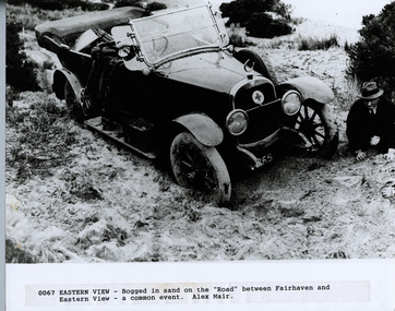 Lorne Historical Society
Photograph, Great Ocean Road. Eastern view. Bogged down in the sand between Fairhaven and Eastern View
Cars being bogged in the sand was a common occurencePhotograph showing man on knees, bogged in sand between Fairhaven and Eastern View ( a common event)great ocean road, fairhaven, eastern view car bogged -
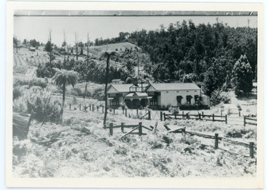
 Mt Dandenong & District Historical Society Inc.
Photograph, Kalorama Guest-house - Front View
Looking down on Kalorama Guest-house from Barbers Road. Property of Ellis and Eliza Jeeves before moving to MountjoyBlack and white photograph with house in foreground and a cleared block and forest in background.KALORAMA Mt Dandenong. FRONT VIEWellis jeeves, jeeves, guest house, kalorama guest-house, barbers road -
University of Melbourne, Burnley Campus Archives
Photograph - Sepia Print, 4. View of River Through Fence
Yarra River.Labelled, " View of River through fence."yarra river, mrs. jessep, alexander william jessep, principal, a.w. jessep -
 University of Melbourne, Burnley Campus Archives
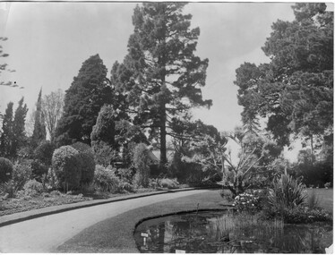
Photograph - Black and white print, Landscape View, c. 1916
Black and white photograph. Luffmann Ponds in the foreground and Principal's Residence in the background. On reverse, "Landscape View Burnley Gardens."luffmann ponds, principal's residence, burnley gardens, garden view, lily ponds -
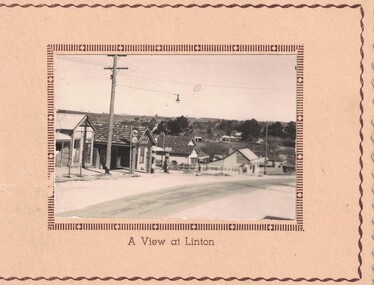 Linton and District Historical Society Inc
Card, Greeting card : 'A view at Linton'
Card thought to have been made in 1940s.Cream-coloured greeting card with attached photograph showing Sussex Street, Linton. Card has never been used."A View at Linton" printed beneath photograph.greeting cards, sussex street linton -
 University of Melbourne, Burnley Campus Archives
Photograph - Black and white print, Garden View, Unknown
Note by T.H. Kneen, "View from the Principal's Residence to the SE corner of the Gardens. Prominent tree is Cupressus macrocarpa (Monterey Cypress) one of the earliest trees planted, no longer existant. Removed 1984.Black and white photograph. Garden view from Principal's Residence to the SE corner of the Gardens (T. H. Kneen). Prominent tree is Cupressus macrocarpa (Monterey Cypress) one of the earliest trees planted, no longer existant. Labels on plants in the foreground.principal's residence, gardens, cupressus macrocarpa, monterey cypress, garden view -
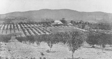 Ringwood and District Historical Society
Photograph, View from Canterbury Road/Balfour Avenue area overlooking Martell's orchard, Heathmont, 1929
Black and white photograph of orchard. House in middle range, mountains in background. Photograph appears to be reproduced from subdivisional brochure. Note inserted in sleeve reads, "It has been pointed out that the mountains are to the east and the view is looking south. This therefore is not a 'straight' photograph. House still exists in Eden Avenue at October, 1996".(3 copies).Typed below photograph, "Panoramic view taken on the estate". "View overlooking Martell's orchard, Heathmont, 1929". Taken from corner Canterbury Rd. and Balfour Ave. looking south. Dandenong Creek just beyond house. Washusen Rd. on right". Written on back of one of the copies, "Heathmont Station Estate 1922". "Station Street, Lisgoold St. Canterbury Rd. Vivienne Cres. Balfour Ave." -
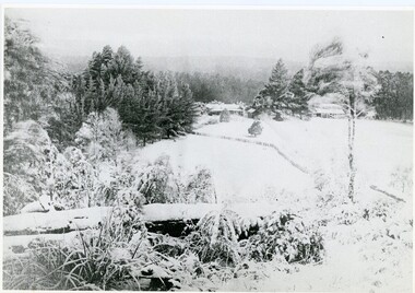 Mt Dandenong & District Historical Society Inc.
Photograph, A View Over Mountain Grange 1921, 1921
A view of Mountain Grange Homestead built by Thomas Hand with buildings and ground covered in snow. The photograph has historical information on the back handwritten by John Lundy-Clarke in 1976.1921 A view over “Mountain Grange” from the side of Mt Kalorama above where Grange Road is now. On the left of the homestead is the avenue of pine trees under which the annual Sunday School picnic was held. On the right is the giant pine that still stands (1976) and the great barn. The separate kitchen of the homestead can be clearly seen. mountain grange, snow, john lundy-clarke, thomas hand -
National Vietnam Veterans Museum (NVVM)
Film - Film, Video, Vietnam: the ten thousand day war: America's thirty years
vietnam war, 1961-1975 - participation, american -
 Victorian Railway History Library
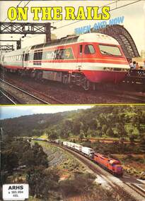
Book, Kelson, Mike, On The Rails Then And Now, 1984
A pictorial essay of Australian railways in the past and the present up to 1984ill, p.56.non-fictionA pictorial essay of Australian railways in the past and the present up to 1984locomotives -- australia -- pictorial works, railroad trains -- australia -- history -- pictorial works. -
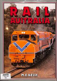 Victorian Railway History Library
Book, View Productions, Rail Australia, 1987
A pictorial essay of Australian railways in the present up to 1987ill, p.128.non-fictionA pictorial essay of Australian railways in the present up to 1987locomotives -- australia -- pictorial works, railroad trains -- australia -- history -- pictorial works.