Showing 202 items
matching walking track
-
 Eltham District Historical Society Inc
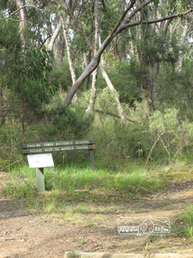
Photograph, Liz Pidgeon, Pauline Toner Butterfly Reserve, Eltham, 18 February 2011, 18 February 2011
Signage in the Pauline Toner Butterfly Reserve asking visitors to keep to marked tracks. The Reserve at the corner of Pitt Street and Eucalyptus Road, Eltham is managed by Parks Victoria. It is named for Pauline Toner M.P. who after the re-discovery of the rare Eltham copper Butterfly in large numbers in Eltham in 1987 worked to preserve its habitat. Born Digitalpauline toner reserve, eucalyptus road, copper butterfly, walking trail, sign, nature reserve -
 Kiewa Valley Historical Society
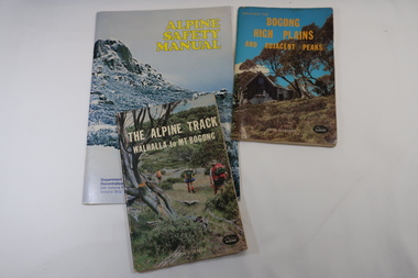
Books x3 - Walking on the Bogong High Plains, 1. The Alpine Track Walhalla to Mt Bogong. 2. Bogong High Plains and Adjacent Peaks both by John Siseman 3. Alpine Safety Manual
Books were published to guide walkers travelling long distances in remote areas increasing their safety and giving them independence.Bogong High Plains and Mt Bogong are at the upper end of the Kiewa Valley where local people and visitors spend their leisure time, walking.1. and 2. both written by John Siseman, small (pocket size), includes maps and black & white photos. The covers are colored photos with the title at the top. 1. has 78 pages and 2. has 63 pages.The Alpine Safety Manual (in yellow) is twice the size of the others and published by the Department of State Development, Decentralization and Tourism.It has 40 pages, coloured and black & white photos and is held by 2 staples.bush walking, bogong high plais, walhalla to mt bogong, alpine track -
 Orbost & District Historical Society
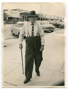
Photograph - Photograph off Albert Trewin
Albert (Abby) Trewin (b.21.03.1876 d. 01.07.1970) was part of the Trewin family who were early settlers at Jarrahmond near Orbost. Albert was born at Kingston near Ballarat, shifted to Jarrahmond where the house was called "Hillview", located 3 miles from Orbost on the B Road. The Trewin selection at Jarrahmond had many big trees on it and because these looked a bit like Jarrah trees from Western Australia, they names their property Jarrahmond (which became the district location and the name of Jarrahmond School). He cleared the land with bullocks, horses, crosscut saws, burned the stumps, burying some logs which were too big to burn. Then they milked cows, planted maize, had pigs, drove the pigs to Bairnsdale or to Waygara (c. 1915 when the train reached Waygara) on a buggy track through the bush. Pigs went to Dandenong Bacon Factory where they were processed into Dandy Ham. This photograph appears to be c.1950s - 1960s.A photograph of one of Jarrahmond's earliest settlers.B/W photograph of a man walking along a footpath. He is wearing a hat and has a walking stick in his right hand. He is wearing braces, white long-sleeved shirt, striped tie, glasses, polished black shoes. Behind him are vehicles and buildings (shops). jarrahmond, farming -
 Marysville & District Historical Society
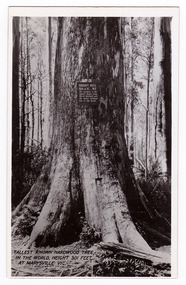
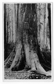
Postcard (item) - Black and white postcard, Valentine Publishing Co. Pty. Ltd, Tallest Known Hardwood Tree in the World, Height 301 Feet at Marysville, Vic. V10, 1923-1963
... . It is a mountain ash. There is a walking track through the forest ...An early black and white photograph of the Big Tree in Cambarville in Victoria.An early black and white photograph of the Big Tree in Cambarville in Victoria. It was, at one stage, known to be the tallest hardwood tree in the world standing at 92 meters (301ft, 6 inches). However, it was reduced to 84 meters by a wind storm in 1959. It is a mountain ash. There is a walking track through the forest that will take you to the Big Tree. This postcard was published by Valentine Publishing Co. Pty. Ltd. as a souvenir of Marysville.VALENTINE'S/ POST/ CARD A GENUINE PHOTOGRAPHbig tree, mountain ash, cambarville, victoria, valentine publishing co, postcard, souvenir -
 Marysville & District Historical Society
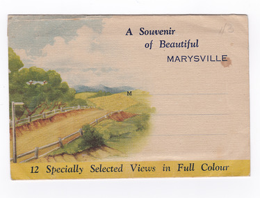
Postcard (item) - Colour photographs, Nucolorvue Productions, A Souvenir of Beautiful Marysville-12 Specially Selected Views in Full Colour, 1950's
An envelope of 12 colour photographs of attractions in and around Marysville in Victoria.An envelope of 12 colour photographs of attractions in and around Marysville in Victoria. These photographs were produced by Nucolorvue Productions in Mentone, Victoria.A Souvenir of Beautiful MARYSVILLE 12 Specially Selected Views in Full Colour Marysville, Victoria, Australia Marysville, 60 miles from Melbourne, is one of nature's/ lovely beauty spots. The invigorating mountain air helps the/ visitor to enjoy the many delightful walks amongst the tall/ timber, or through the fern glades. Apart from many excellent walking trips, Marysville district/ offers ample scope for car trips to the nearby Cumberland Forest,/ Buxton, Narbethong, or the Taggerty Valley. Skiers find Lake Mountain an attraction in the winter, whilst/ the hiker finds ample for his needs in the numerous mountain/ areas. Huge Eucalypt trees, revealing their ramrod straightness up/ to 300 feet in height, are a fitting background to the many/ beautiful creeks and waterfalls. PUBLISHED BY NUCOLORVUE PRODUCTIONS, MENTONE, VICTORIA.nicholl's lookout (image 1), eildon weir (image 2), road to lake mountain (image 3), foot of steavenson falls (image 4), steavenson falls (image 5), bush scene near marysville (image 6), bush track marysville (image 7), bridge and chalet and crossways marysville (image 8), log cabin at marysville (image 9), black spur (image 10), taggerty river (image 11), highest known hardwood tree (image 12), marysville, victoria, nucolorvue productions, postcard, souvenir -
 Marysville & District Historical Society
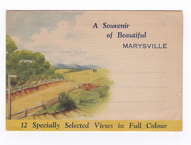
Postcard (item) - Colour photographs, Nucolorvue Productions, A Souvenir of Beautiful Marysville-12 Specially Selected Views in Full Colour, Unknown
An envelope of 12 colour photographs of attractions in and around Marysville in Victoria.An envelope of 12 colour photographs of attractions in and around Marysville in Victoria. These photographs were produced by Nucolorvue Productions in Mentone, Victoria.A Souvenir of Beautiful MARYSVILLE 12 Specially Selected Views in Full Colour Marysville, Victoria, Australia Marysville, 60 miles from Melbourne, is one of nature's/ lovely beauty spots. The invigorating mountain air helps the/ visitor to enjoy the many delightful walks amongst the tall/ timber, or through the fern glades. Apart from many excellent walking trips, Marysville district/ offers ample scope for car trips to the nearby Cumberland Forest,/ Buxton, Narbethong, or the Taggerty Valley. Skiers find Lake Mountain an attraction in the winter, whilst/ the hiker finds ample for his needs in the numerous mountain/ areas. Huge Eucalypt trees, revealing their ramrod straightness up/ to 300 feet in height, are a fitting background to the many/ beautiful creeks and waterfalls. PUBLISHED BY NUCOLORVUE PRODUCTIONS, MENTONE, VICTORIA.nicholl's lookout (image 1), eildon weir (image 2), road to lake mountain (image 3), foot of steavenson falls (image 4), steavenson falls (image 5), bush scene near marysville (image 6), bush track marysville (image 7), bridge and chalet and crossways marysville (image 8), log cabin at marysville (image 9), black spur (image 10), taggerty river (image 11), highest known hardwood tree (image 12), marysville, victoria, nucolorvue productions, postcard, souvenir -
 Marysville & District Historical Society
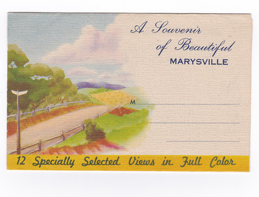
Postcard (item) - Colour photographs, Nucolorvue Productions, A Souvenir of Beautiful Marysville-12 Specially Selected Views in Full Colour, Unknown
An envelope of 12 colour photographs of attractions in and around Marysville in Victoria.An envelope of 12 colour photographs of attractions in and around Marysville in Victoria. These photographs were produced by Nucolorvue Productions in Mentone, Victoria.A Souvenir of Beautiful MARYSVILLE 12 Specially Selected Views in Full Colour Marysville, Victoria, Australia Marysville, 60 miles from Melbourne, is one of nature's/ lovely beauty spots. The invigorating mountain air helps the/ visitor to enjoy the many delightful walks amongst the tall/ timber, or through the fern glades. Apart from many excellent walking trips, Marysville district/ offers ample scope for car trips to the nearby Cumberland Forest,/ Buxton, Narbethong, or the Taggerty Valley. Skiers find Lake Mountain an attraction in the winter, whilst/ the hiker finds ample for his needs in the numerous mountain/ areas. Huge Eucalypt trees, revealing their ramrod straightness up/ to 300 feet in height, are a fitting background to the many/ beautiful creeks and waterfalls. PUBLISHED BY NUCOLORVUE PRODUCTIONS, MENTONE, VICTORIA.nicholl's lookout (image 1), eildon weir (image 2), road to lake mountain (image 3), foot of steavenson falls (image 4), steavenson falls (image 5), bush scene near marysville (image 6), bush track marysville (image 7), bridge and chalet and crossways marysville (image 8), log cabin at marysville (image 9), black spur (image 10), taggerty river (image 11), highest known hardwood tree (image 12), marysville, victoria, nucolorvue productions, postcard, souvenir -
 Marysville & District Historical Society
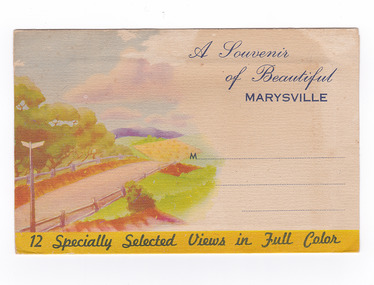
Postcard (item) - Colour photographs, Nucolorvue Productions, A Souvenir of Beautiful Marysville-12 Specially Selected Views in Full Colour, Unknown
An envelope of 12 colour photographs of attractions in and around Marysville in Victoria.An envelope of 12 colour photographs of attractions in and around Marysville in Victoria. These photographs were produced by Nucolorvue Productions in Mentone, Victoria.A Souvenir of Beautiful MARYSVILLE 12 Specially Selected Views in Full Colour Marysville, Victoria, Australia Marysville, 60 miles from Melbourne, is one of nature's/ lovely beauty spots. The invigorating mountain air helps the/ visitor to enjoy the many delightful walks amongst the tall/ timber, or through the fern glades. Apart from many excellent walking trips, Marysville district/ offers ample scope for car trips to the nearby Cumberland Forest,/ Buxton, Narbethong, or the Taggerty Valley. Skiers find Lake Mountain an attraction in the winter, whilst/ the hiker finds ample for his needs in the numerous mountain/ areas. Huge Eucalypt trees, revealing their ramrod straightness up/ to 300 feet in height, are a fitting background to the many/ beautiful creeks and waterfalls. PUBLISHED BY NUCOLORVUE PRODUCTIONS, MENTONE, VICTORIA.nicholl's lookout (image 1), eildon weir (image 2), road to lake mountain (image 3), foot of steavenson falls (image 4), steavenson falls (image 5), bush scene near marysville (image 6), bush track marysville (image 7), bridge and chalet and crossways marysville (image 8), log cabin at marysville (image 9), black spur (image 10), taggerty river (image 11), highest known hardwood tree (image 12), marysville, victoria, nucolorvue productions, postcard, souvenir -
 Marysville & District Historical Society
Booklet - Paperback booklet, Maroondah Bushwalking Club Inc, Day Walks Around Marysville, 1996
A booklet outlining day walks of various difficulties in and around the surrounds of Marysville.Paperback booklet. Front cover shows title with a cartoon drawing of a pair of walking boots. Back cover shows details of the publisher and distributor of the publication.non-fictionA booklet outlining day walks of various difficulties in and around the surrounds of Marysville.marysville, victoria, day walks, bushwalking, maroondah bushwalking club, cathedral range, sugarloaf peak, neds gully, maroondah highway, woods lookout, cement creek, acheron, lake mountain, snowy hill, cumberland reserve, wilks creek, mount strickland, the beeches, mount margaret, stevensons falls, steavensons falls, de la rue lookout, oxlee lookout, keppel lookout, keppel hut, north jawbone peak, cumberland scenic reserve, acheron road, buxton, man o war track, phantom falls, keppel falls, athols abbey, sunds road, trestle track, booklet -
 Marysville & District Historical Society
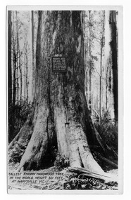
Postcard (item) - Black and white postcard, Valentine Publishing Co. Pty. Ltd, Tallest Known Hardwood Tree in the World, Height 301 Feet at Marysville, Vic. V10, 1923-1963
... . It is a mountain ash. There is a walking track through the forest ...An early black and white photograph of the Big Tree in Cambarville in Victoria.An early black and white photograph of the Big Tree in Cambarville in Victoria. It was, at one stage, known to be the tallest hardwood tree in the world standing at 92 meters (301ft, 6 inches). However, it was reduced to 84 meters by a wind storm in 1959. It is a mountain ash. There is a walking track through the forest to the Big Tree. This postcard was published by Valentine Publishing Co. Pty. Ltd. as a souvenir of Marysville.VALENTINE'S/ POST/ CARD A GENUINE PHOTOGRAPHbig tree, mountain ash, cambarville, victoria, valentine publishing co, postcard, souvenir -
 Marysville & District Historical Society
Postcard (item) - Black and white postcard, Valentine Publishing Co. Pty. Ltd, Tallest Known Hardwood Tree in the World, Height 301 Feet at Marysville, Vic. V10, 1923-1963
... . It is a mountain ash. There is a walking track through the forest ...An early black and white photograph of the Big Tree in Cambarville in Victoria.An early black and white photograph of the Big Tree in Cambarville in Victoria. It was, at one stage, known to be the tallest hardwood tree in the world standing at 92 meters (301ft, 6 inches). However, it was reduced to 84 meters by a wind storm in 1959. It is a mountain ash. There is a walking track through the forest that will take you to the Big Tree. This postcard was published by Valentine Publishing Co. Pty. Ltd. as a souvenir of Marysville.VALENTINE'S/ POST/ CARD A GENUINE PHOTOGRAPH Dear Mother & Dad I received your letter and/ was glad to know everything is OK at home./ The weather is still pretty good. Today is dull/ with a drop of rain every now & then but not enough/ to stop you from going out. Tomorrow we are going/ to the Eildon Weir so we are hoping it stays fine./ Had a letter from Mrs Thompson. She says Alison is/ doing fine. She has been playing with Judy/ You didnt way whether you were coming up here or/ not but I doubt whether you will get in after next/ week as it is the school holidays. Cumberland House/ seems to be very nice + it is on the main road let me/ know by return post & Ill see what I can do for you./ I think the tariff seems to be the same. Well dear thats all for/ now as I want to send a card to Auntie Love Ethel & Clarriebig tree, mountain ash, cambarville, victoria, valentine publishing co, postcard, souvenir -
 Marysville & District Historical Society
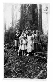
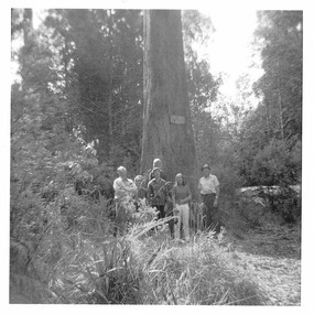
Photograph (item) - Black and white photograph, 02-1949
... . It is a mountain ash. There is a walking track through the forest ...An early black and white photograph of the Big Tree in Cambarville in Victoria.An early black and white photograph of the Big Tree in Cambarville in Victoria. It was, at one stage, known to be the tallest hardwood tree in the world standing at 92 meters (301ft, 6 inches). However, it was reduced to 84 meters by a wind storm in 1959. It is a mountain ash. There is a walking track through the forest to the Big Tree.932 February 1949 Marysvillebig tree, mountain ash, cambarville, victoria, photograph -
 Marysville & District Historical Society
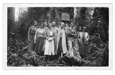
Photograph (item) - Black and white photograph, 12-1935
... . It is a mountain ash. There is a walking track through the forest ...An early black and white photograph of the Big Tree in Cambarville in Victoria.An early black and white photograph of the Big Tree in Cambarville in Victoria. It was, at one stage, known to be the tallest hardwood tree in the world standing at 92 meters (301ft, 6 inches). However, it was reduced to 84 meters by a wind storm in 1959. It is a mountain ash. There is a walking track through the forest to the Big Tree.SUTHERLAND/ STUDIO/ HEALESVILLE Tall Trees at Cumberland/ Dec 1935big tree, mountain ash, cambarville, victoria, photograph -
 Marysville & District Historical Society
Photograph (item) - Black and white photograph, Unknown
... . It is a mountain ash. There is a walking track through the forest ...An early black and white photograph of the Big Tree in Cambarville in Victoria.An early black and white photograph of the Big Tree in Cambarville in Victoria. It was, at one stage, known to be the tallest hardwood tree in the world standing at 92 meters (301ft, 6 inches). However, it was reduced to 84 meters by a wind storm in 1959. It is a mountain ash. There is a walking track through the forest to the Big Tree.The tallest Mountain Ash at the/ Cumberlandbig tree, mountain ash, cambarville, victoria, photograph -
 Marysville & District Historical Society
Photograph (item) - Colour photograph, Unknown
... . There is a walking track through the forest to the Big Tree. big tree ...A colour photograph of the Big Tree in Cambarville in Victoria.A colour photograph of the Big Tree in Cambarville in Victoria. It was, at one stage, known to be the tallest hardwood tree in the world standing at 92 meters (301ft, 6 inches). However, it was reduced to 84 meters by a wind storm in 1959. It is a mountain ash. There is a walking track through the forest to the Big Tree.big tree, mountain ash, cambarville, victoria, photograph -
 Marysville & District Historical Society
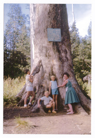
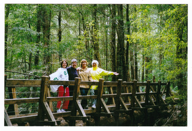
Photograph (item) - Colour photograph, 15-11-03
... . It is a mountain ash. There is a walking track through the forest ...A colour photograph of a bridge that leads to Big Tree near Cambarville in Victoria.A colour photograph of a bridge that leads to Big Tree near Cambarville in Victoria. It was, at one stage, known to be the tallest hardwood tree in the world standing at 92 meters (301ft, 6 inches). However, it was reduced to 84 meters by a wind storm in 1959. It is a mountain ash. There is a walking track through the forest to the Big Tree.A weekend at Marysville 15-11-03 Catherine Pat Natasha & Normabig tree, mountain ash, cambarville, victoria, photograph -
 Marysville & District Historical Society
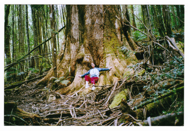
Photograph (item) - Colour photograph, 15-11-03
... . There is a walking track through the forest to the Big Tree. big tree ...A colour photograph of the Big Tree in Cambarville in Victoria.A colour photograph of the Big Tree in Cambarville in Victoria. It was, at one stage, known to be the tallest hardwood tree in the world standing at 92 meters (301ft, 6 inches). However, it was reduced to 84 meters by a wind storm in 1959. It is a mountain ash. There is a walking track through the forest to the Big Tree.Catherine at Marysville 15-11-03big tree, mountain ash, cambarville, victoria, photograph -
Marysville & District Historical Society
Flyer (item) - Information flyer, Artworkz Tourism, Marysville-The Big Tree, 15-07-2020
... in 1959. It is a mountain ash. There is a walking track through ...A flyer that was produced as a guide to the Big Tree near Marysville in Victoria.A flyer that was produced as a guide to the Big Tree near Marysville in Victoria. The Big Tree was, at one stage, known to be the tallest hardwood tree in the world standing at 92 meters (301ft, 6 inches). However, it was reduced to 84 meters by a wind storm in 1959. It is a mountain ash. There is a walking track through the forest to the Big Tree.big tree, mountain ash, cambarville, victoria, marysville -
Marysville & District Historical Society
Document (item) - Word document, Rene de Koning, The Cumberland Giant Tree, 09-11-2022
... . There is a walking track through the forest to the Big Tree. big tree ...An account of the early history of the Cumberland Giant Tree near Marysville in Victoria.An account of the early history of the Cumberland Giant Tree near Marysville in Victoria. The Big Tree was, at one stage, known to be the tallest hardwood tree in the world standing at 92 meters (301ft, 6 inches). However, it was reduced to 84 meters by a wind storm in 1959. It is a mountain ash. There is a walking track through the forest to the Big Tree.big tree, mountain ash, cambarville, victoria, marysville -
 Marysville & District Historical Society
Photograph (Item) - Black and white photograph, Beech Forest Beyond Tommy's Bend, c1900
... of the many walking tracks in and around Marysville. It is accessible ...An early black and white photograph of The Beeches, which is known as the Beech Grove, near Tommy's Bend near Marysville in Victoria.An early black and white photograph of The Beeches, which is known as the Beech Grove, near Tommy's Bend near Marysville in Victoria. Tommy's Bend is a stretch of road 10 kilometres from Marysville on the Wood's Point Road up to Lake Mountain. The Beeches Rainforest Walk is a loop that starts at Taggerty Cascades before winding through Myrtle Beech and Mountain Ash woodland and is one of the many walking tracks in and around Marysville. It is accessible from Lady Talbot Drive which is a 24 kilometer scenic rainforest car journey which passes a number of walks and waterfalls in the Yarra Ranges National Park. Lady Talbot Drive is named after Lady Sarah Elizabeth, the wife of Sir Reginald Talbot, who was the Governor of Victoria from 25th April, 1904 to 6th July 1908.ARMSTRONG COLLECTION 42 STATION STREET/ SANDRINGHAM 3191/ TEL. (03) 9521 5442/ IAN M.L. ARMSTRONG OAMtommy's bend, marysville, victoria, marysville-wood's point road, beech grove, wood's point road, lake mountain, beeches rainforest walk, taggerty cascades, myrtle beech, mountain ash, lady talbot drive, lady talbot forest drive, lady sarah elizabeth talbot, sir reginald talbot -
Federation University Historical Collection
Document, Zelda Martin, Central Victorian Goldmining towns - Boom Towns or Ghost Towns?, c1996
Zelda Martin was a PhD candidate at the University of Melbourne.[.1] 4th item in light blue display book titled Research Approach/Overview of Chapters/Confirmation of Canditure/Chapters1,2,3&4 of proposed thesis. *Twenty-seven page article on Victorian goldfields towns titled: Central Victorian Goldmining Towns - Boom Towns or Ghost Towns. The article was written during the author's PhD study. It outlines the context methodology, and resources and the chapters of the proposed thesis: (1) Central Victorian Goldmining Towns - The Context (2) Contemporary Views of the Factors Necessary for Town Growth (3) Outward Manifestations of Town Growth (4) The Trappings of Government (5-9) The Main Towns and Their Hinterland. [.2] 5th item in Light Blue display book as above item. *Chapter 1 of proposed thesis titled 'Pick, Shovel and Tin Dish Mining.' Covers in Section A: Central Victoria - Pre 1851: Aborigines in Central Victoria, Squatters, and Government. Section B: The years 1851-1854: The Early Gold Rushes, Government Reaction, Township Surveys, Legislation, Town Development, Local Government and Early Settlement. [.3] 6th item in Light Blue display book as above item. *2A of proposed thesis titled 'Contemporary Views of the Factors Necessary for Town Growth'. Similar information to Chapter 1 plus extra re towns and maps. Sections: Introduction, Context of Place - Geographical Towns Listed, The Context of Time - Pre1851 Aborigines, Governance of Port Phillip, The Squatters, The Villages of Central Victorian Highlands, Conclusion, Condensed Version of Chapter2B. [.4] 7th item in Light Blue display book as above item. *Chapter2B of proposed thesis. Sections: Area of Research, Schools, Banks, Newspapers, Progress Association, Town Development - Sandhurst (Bendigo), Ballarat, Castlemaine,, Maryborough, Ararat and Stawell. [.5] 8th item in Light Blue display book as above item. *Chapter 3 of proposed thesis titled 'Outward Manifestations of Town Growth'. Sections: Introduction, Contemporary Writing, Educationalists, The Bankers, The Townsfolk, Current Theory, General Theories of Urban Development, and Conclusion. [.6] 9th item in Light Blue display book as above item. *Chapter 4 of proposed thesis titled 'Trappings of Government' Sections: Introduction, Early Government Attitudes to Mining and Town Development, Law and Order, Township Surveys, Legislation, Local Government, Transport and Communication, The People and Lobbyists. [.7] 10th item in Light Blue display book as above item. *'The Rise and Fall of Central Victorian Goldmining Towns'. Includes a map showing main Goldfields, a table showing towns and villages at two points in time - 1857 and 1871; a Bibliography of Primary and Secondary Sources. [.8] Resource No1. Black display book titled Local Towns 1 : Alma: *Brief history *Directory *Maps Amphitheatre / Mountain Hut: *Brief History Post Office Directory Ararat: *Brief History *Post Office Directory 1869 - Alphabetical Listing by Occupation *Ararat - Prominent Citizens of 1858 *Langi-Morgala Museum Avoca: *Brief History *Excerpts from 'Avoca The Early Years', Margery and Betty Beavis; pg1 - Beginnings; pg11 - The Midas Touch; pg25 - Local Gold Escorts; pg27 - A Town is Born; pg51- The Administration of Justice; pg53 - The Ways of the Law; pg61 - News of the Day; pg65 - A Time to Play; pg72 - Land Ownership *Post Office Directory (Bailliere's) 1869 *Tourism Map and Information of area *Historic Avoca - A 5.5km Tour *Avoca & the Pyrenees Region - information pamphlet Ballarat: *Early History of Ballarat - Ballarat Historical Society, Publication No.1: origin of the name; Ballaarat - the Beginning; Fabulous Yields from the Ballaarat Goldfield; *Streetscape Lydiard Street. *Hand drawn map showing Leigh River, Old Portland Bay Road, plaque on road to Colac; etc. *Newspaper article re 'The Theatre Royal' ( which stood in the vicinity of the current Owen Williams store) - 'The News'15/04/1998 *Article - 'Ballarat's Mechanics' Institute Lives On' Ballarat Courier, 14/09/1985 *Article - Standing the Test of Time' The News 17/11/1993 re The Mechanics Institute & picture of the Reading Room *'Ballarat a Study of a City, Phyllis Reichl, pub. Nelson, 1968; no.3 place, time and people field studies series *Investigator Vol.33 No.2, 1998 Geelong Historical Society. Article on pg75 describes Ballarat in 1861 *Folded poster - 'Ballarat 100' a history of telegraph communication, pub. Telecom. Beaufort (Fiery Creek): *Brief history *Post Office Directory [.9] Resource No.2 Black Folder Titled Towns cont.No2 Bendigo (Sandhurst): *'Family & Local History at the Bendigo Library - 1851-2001 150 years of gold'. *Bendigo Government Camp in 1853 illustration; key to sketch and names of Government officers stationed there *Excerpts from 'Bendigo and Vicinity' Adolph Haman *The Bendigo Goldfield Registry - pgs 1-7 Introduction *Excerpt: 'Breaking the Grip' *Excerpt: The Most Go-Ahead Place *Excerpts from 'History of Bendigo' - anti license agitation; laying out of town; proposed railway; gold calls and dividends; the Sandhurst Municipality; journalism *Bibliography Blackwood: *Excerpts from 'Aspects of Early Blackwood - The Goldfield, the Landmarks, the Pioneers' Alan J Buckingham and Margaret F Hitchcock, JG Publishing,1980 Buninyong: *A Brief History *Investigator Vol1 No.2 Feb 1966 Geelong Historical Society. Pg3 - Article re gold escort route - Mt Alexander to Adelaide - (see a simple monument on the Western Highway a few miles out of Horsham. Pg 15 - Ballarat Excursion - re the finding of gold. *Three articles published by Buninyong and District Historical Society Inc: (Magpie Exploration; Finding Gold In The Green Hills; Magpie Exploration; Burnt Bridge to Cargarie to Mt Mercer) *Copies of newspaper articles/items *Buninyong Street Directory Carisbrook: *In the Beginning There Was Carisbrook *The History of the Carisbrook Racecourse Carngham / Snake Valley: *Brief History *Directory Castlemaine: *Directory 1865-1866 - Alphabetical and Street *Poster - Castlemaine A Contemporary Guide "The Great Centre" 1866 - A Contemporary Guide to the Fascinating Past *Pamphlet - Castlemaine District Community Hospital *Map - Castlemaine, Maldon & Surrounding Districts *Map and Information - The Dry Diggings Track - a 55kl walk among historic goldfields relics ( Castlemaine Fryerstown Vaughan Mt Franklin Hepburn Daylesford) *Postcard - Former Court House *Directory 1867 - Alphabetical, Trade [.10] Resource No.3 Grey folder Titled Towns 3 Creswick to Maryborough Creswick: *Brief History *Booklet - "Creswick Cemetery Walk" *Booklet - The Buried Rivers of Gold Heritage Trail Creswick *Creswick Historical Museum Information Sheet *Chronological History of Creswick *Alphabetical Directory of the Borough of Creswick *Creswick's Creek Directory 1856 *Historic Creswick Walking Tour *A Brief Account of the Schools of Creswick - Past and Present *100 Years of Railway Travel in Creswick *The Berry Deep Leads *The Spence Home at Jackass Gully in the Creswick State Forest ( William Guthrie Spence - Pioneer) *The New Australian Mine and the 1882 Disaster *Creswick District News, Issue 7, July August 1999 *The Creswick Miners Walk - Information and Map *Maps Chewton: *Brief History *Directory Clunes: *Brief History *Clunes Street Directory Daylesford: *Brief History *Notable Bushfires in Daylesford District Over More Than a Century - "Black Thursday" 1851; 1862; 1899; the Disastrous Hepburn Fire of 1906; 1939; 1944; 1969. *Post Office Directory -Daylesford and Hepburn Dunolly / Inkerman: *Brief History *Directory *Pamphlet - Goldfields Historical Museum *Pamphlet - Historic Dunolly - Victoria's Best Kept Secret *Map of Gold Workings at Dunolly Area - showing where the main gold rushes occurred *Brief History - Inglewood *Directory - Inglewood - Name Occupation, Dwelling Kingower: *Brief History *Directory - Name / Ocupation / Dwelling Linton / Happy Valley / Piggoreet: *Brief History *Directory - Lintons McIvor: *"A History of the Shire and the Township of Heathcote" by J.O. Randell Majorca: *Brief History *Official Post Office Directory 1869 - Name / Occupation/ Address Maldon (Tarrangower): *Brief History Part 1 *Brief History Part 2 *Post Office Directory *List - Alphabetical Order by Names plus Business and Trade (Tarrangower Times Oct/1858) *List - Alphabetical Order by Trade plus Name and Business *Directory - Name / Occupation / Dwelling Maryborough: *Worsley Cottage - built by Arthur Worsley, a contractor in stonework in 1894 [.11] Resource No. 4 Blue Display Book titled Towns 4 Moliagul to Stawell Moliagul: *Brief History *Moligul Legislative Assembly (Voting?) List - Names and Occupations *Moliagul Victorian Post Office Directory 1868 - Name / Ocupation / Address / Comments *"The Welcome Stranger" gold nugget *The Sunday School *The Welcome Stranger Discovery Walk - information and map Moonambel (Mountain Creek) Redbank *Brief History *List of names extracted from advertisments of the Pioneer and Mountain Creek Advertiser 16/02/1861. *Bailliere's Directory 1869 - Alphabetical List of Name / Occupation / Place St Arnaud: *Brief History Sebastapol: *Brief History *Directory 1869 - Alphabetical by Name; plus occupation and address. Browns and Scarsdale: *Brief History *Browns Street Directory - Name and Occupation Smythesdale: *Brief Description *Smythesdale Street Directory -Name and Occupation Stawell (Pleasant Creek) *Brief History *Victorian Official Post Office Directory - Name /Occupation / Dwelling *Chronology - 1841-1920 *Production of gold statistics - 1879 - 1900 *Big Hill *Extracts from "The Golden Years of Stawell". Chapt 1 - Stawell's Coming Out. Capt. 2 - The Gold Rush. Caapt.3 - Cradle of Democracy. Chapt.4 - The Reefs Becomes Stawell. Chapt. 5 - Rushing In. Chapt.6 - The Pioneers. Chapt 7 - The Decade of Optimism. [.12] Resource No. 5: Blue Display Book titled 'Towns Steiglitz to the The Golden Triangle. Steiglitz: Brief History Victorian Post Office Directory 1869 *Map of Steiglitz *List of maps relevant to Steiglitz history *Information 6 tables of data from "Reports of Mining Surveyors Talbot (Back Creek) Brief History Taradale: Post office Directory 1869 - Name/Occupation/Street. Also list in alphabetical order by Occupation Taradale *Chronological Reference to Taradale Mines *Water - The Coliban System of Waterworks *Joseph Brady *The Syphon Tarnagulla (Sandy Creek) *Brief History *Tarnagulla Businessmen Cameos to give depth to advertisments in 'The Tarnagulla Courier' various issues 1864-1871 *Directory - Name/Occupation /Address *List - Name/Business/Trade Wedderburn (Koorong) *Brief History *List - Name/Occupation The Golden Triangle: *The Early Rushes - Wedderburn / Moliagul / Sandy Creek - Tarnagulla / Jones Creek - Waanyarra / Kingower / Dunolly - Goldsborough / Inglweood *Census of 1857 - Population / Occupations *1858-1871 - A Time of Consolidation- Wedderburn / Moliagul / Sandy Creek- Tarnagulla / Arnold *Census 1871 - Population *Information gleaned from the census data - Demographics / Population / Occupations / marital / Birthplace / Religion / Literacy/ Occupation and Housing Cameos *Graphs - Birthplace of settlers /Male-Female Ratio / Married males / Children under 15 as Percentage of Population / Religion *Census 1857 - Statistical data *Maps *Bibliography [.13] Resource No. 6 - Black Display Book Information and Research in Central Victoria including: *Banking - Research from ANZ Bank Archives *Institutions - also includes articles listed from the Ballarat Times Newspaper *Australian mining History Association - A.M.H.A. Bibliography *Australia's Mining History * Bibliography - Land Surveys Victoria - *1853 Administration (Statistics and Other) includes: schools / ministers of religion / police / military / local administration / licences for sale of spirits / distances between various Victorian gold fields. * Victoria Government Gazette (Copy) - N0. 116, 12/12/1854 includes: Gold Felds Commission of Enquiry & No. 85, 15/09/1854 - Addresses presented to the Lieutenant Governor (Sir Charles Hotham) during his tour through the Gold Fields of Victoria,1854. Addresses on behalf of : the people of Bendigo; Members of the Church of England, Bendigo; Members of the Wesleyan Church on the Bendigo Gold Fields; Bendigo Gold District General Hospital; the Bendigo Prospecting Association; Committee of the Bendigo Local Exhibition; Bendigo District Medical Association; Coloured Americans Resident at Bendigo; German Inhabitants of Bendigo; Landowners, Inhabitants, and Miners of Castlemaine; Inhabitants of Forest Creek; Inhabitants of Heathcote and Gold Miners of McIvor; Residents and landholders of the District of Bacchus Marsh; Inhabitants of Kilmore and Vicinity. *Gold Fields Correspondence 1853: letter from Lieutenant Colonel Valiant, (Officer commanding the Troops in Victoria) to the Lieutenant Governor re threatened disturbance at Sandhurst (Bendigo) regarding the Gold License Fee. * Extracts from a book "Victoria" re Gold Fields Commission of Enquiry involving mainly Ballarat and Castlemaine and a chapter titled 'A Tour to the Victorian Gold-Fields' *Lists of central Victorian newspapers - listed by date published 1851to 1874; by first date available to State Library. *A list of cities and towns showing County, population in 1861 &1871, and municipal status. [.14] Resource no.7. Black display book. *Reference: Papers presented to Parliament Victoria - 1859-1860 4 volumes - relevant sections copied. Contains information on Branches of Government. General / Finance / Gold / Gazette / Commission and Warrant / Statistic. *Gold Fields Act. In accordance with the Act the gold fields are divided into six districts - Ballaarat, Castlemaine , Sandhurst, Avoca, Ararat, and Beechworth.. Official staff in each gold district consists of a Resident Warden, Wardens, Wardens' Clerks, Bailiffs, Chinese Protectors, Chinese Interpreters, and Mining Surveyors. *Gold Receiver *Gaols *Police magistrates and Clerks of Petty Sessions, etc. *Field Branch *Immigration and Emigration Overland - Chinese - 1859 *Population on the Goldfields *The Geological Survey - The Government Geologist is assisited by staff from four branches - the office Branch; the Publishing Branch; the Field Branch and the Museum Branch. *Commission to Enquire Into Sludge dated 10/02/1859 (Some sections copied) - Report to the Honorable Chief Commissioner of Public Works, Melbourne re the mode of carrying the sludge from the puddling mills in Sandhurst without interfering with the drainage of the town and the roads in the neighbourhood. [.15] Resource No.8: Camel display book titled Resource No. 8. Aborigines *Lists of book titles - +"Readings in Victorian prehistory" +"The Aborigines of Port Phillip" +Aboriginal languages and clans" +"A History of the Port Phillip District" +"Langi Ghiran 1: Aboriginal Rock...." +"Koorie History: sources for aboriginal studies in the State Library of Victoria", ed. Tom Griffiths, Melb. Friends of the State Library, 1989 +"The Public Lands of Australia Felix"; settlement and land appraisal in Victoria1834-91 with special reference to the Western Plains", J.M.Powell, Melb. Oxford University Press 1970 +*Bibliography of the Victorian Aborigines' from the earliest manuscripts to 31st December 1970, Massoa, Aldo, Melb. Hawthorn Press, 1971 +"Aborigines in Colonial Victoria, 1836-1886", M.F. Christie, Sydney University Press, 1979 +"Urban and Industrial Australia: readings in Human Geography" ed J.M. Powell, Melb. Sorrett Pub. 1974 *Extracts: -Processes of Pioneer Settlement - The Squatting Occupation of Victoria, 1834-60. J.M. Powell -Areal Variations in the Class Structure of the Central-Place Hierarchy. P. Scott - Volume1 and Volume 2: Notes Relating to the Habits of the Natives of Other Parts of Australia and Tasmania. Compiled from various sources for the Government of Victoria by R Brough Smyth. John Curry, O'Neil, Melb. 1st pub. Melb. 1876. p31-45 - Numbers and Distribution of the Aborigines in Victoria -Victorian Aborigines 1835-1901 - A Resource Guide to the Holdings of the Public Record Office, Victoria; published by the Government Information Centre 1984. *History of the Aboriginal Artefacts Displayed in the Daylesford Museum. F. G. Powell (4 page pamphlet) *Letter to Zelda Martin from Peter Lovett, Cultural Officer, Ballarat & District Aboriginal Co- Operative, 05/02/1997 *Map: Ian Clarke Victorian Tribunal Boundary Map - Clans of Central Victoria. *Victorian Rock Art and Mythology - Article about Mount Langhi Ghiran and myths of the Tjapwarong people. *Two Aboriginal myths relating to the Grampians - 'The Monster Emu' / 'The Aquisition of Fire', by the Aborigines in the Grampians Areas *Article titled (chapter 8) Ballarat - information re camping sites in the region. Lake Wendouree / Lake Burrumbeet (includes a myth) / Mt Bunninyong / Lal Lal / Pitfield / Mount Elephant / Mount Egerton / Meredith / Lake Goldsmith / Lake Learmonth / Ercildoune *Notes on the Aborigines of the Wider Ballarat Region plus European names=Aboriginal names. John Morris 26/07/1995 *Role of Aborigines in Town Development in Central Victoria. Mentions Native Police Force est. in Port Phillip 1842 and Central Board for Aborigines est. 1860 *The Grave of King Billy. (Frank Wilson) Pamphlet. *Camping Places in Central and Northern Victoria. Article re Lake Burrumbeet site. *Programme for the Unveiling of Memorial Cairn for Edward Stone Parker 1802-1865. Note portrait not accurate. Accurate portrait is available in the book "A Successful Failure A Trilogy The Aborigines and Early Settlers", Edgar Morrison, Graffiti Publications, 2002. * Large envelope addressed to Mr G Netherway containing newspaper cuttings regarding the life of Edward Stone Parker, the unveiling of the Memorial Cairn as mentioned above, articles titled 'Episodes from Our Early Days' (Edgar Morrison, Yandoit)- The Black's School, A School At Last and The Final years. Also a typed page titled 'Historical Background to E.S.Parker's Career. Includes an interesting tale titled 'When the cat lay doggo' re laying power leads for the unveiling ceremony at the memorial site. [.16] green display folder titled 'Research Aids' *List of references to Commissioners' & W'ardens' Reports (formerly held at La Trobe Library Archives, now at Public Records Office [PRO]). Indicates town referred to / date of report / name of camp if different to town. * Archive information re Anglican Records *Movement around the Goldfields - Miners and Storekeepers - usefulness of newspapers in providing information - areas covered - Castlemaine, Maldon, Ararat, Stawell, Tarnagulla, Dunolly. *Port Phillip /Victoria Directories 1839/1867 - Chronological list of Directories included in this series. *"Notes on the History of Local Government in Victoria" A.W. Greig Melb. University Press 1925 - Photo-copied extract p5-p40. (Source - Deakin University Library) - Introduction by W.Harrison Moore. Section 1 - Development in New South Wales Before Separation. Section 2 - Development in Victoria After Its Separation from New South Wales. Hand written notations: 'roads, markets, and local government 1855 on' ;'opportunity of squatters in parliament' and 'opportunities of matters in parliament p33' * Notes on the Establishment of Surveyor General's Department 1851and Commissioner of Crown Lands and Survey. * Newspaper articles from The Argus, 1849, re the discovery of gold in the Pyrenees region. * Excerpt - a report on schools - A.B.Orlebar, Inspector; re the need for permanent school buildings rather than tents. *Excerpt from - 'Approaches to Urban History', Sean Glynn: The Case for Caution * Except from - 'The Urban Sprinkle', Weston Bate: Country Towns and Australian Regional History *Reference- 'The History of Land Tenure in the Colony of Victoria', John Quick. References the Haines Land Bill, land tenure and Land Leagues. [.17] Light blue envelope folder titled 'Birtchnell's Ballarat, etc. Directory 1862 *Contains various directories for Smythesdale, Buninyong, Clunes, Brown's and Creswick. [.18] Red envelope folder no.2 titled Victorian Gazetteer *Selected pages from 1869 Victorian Gazetteer on A4 paper (with a handwritten note questioning if some pages are from 1868 Victorian Gazetteer as appears to be different sizes - A3 pages.) Information includes locations and descriptions of towns, hotels, banks, communications and populations. (Does not include names, residences and occupations) [.19] Red Envelope folder titled Bailliere's Official Post Office Directory 1868 (or1869 or a mixture of both?) *Preface *Contains a selection of pages of towns highlighted in yellow in the the index *Work on this directory was commenced in 1867. *Information includes: Municipalities - mayors and councilors; lists of towns naming male inhabitants and their occupations. [.20]Yellow manila folder titled Post Grad Seminar Presentation 1996 *Gives some background to Zelda Martin's proposed thesis and why she chose the topic Gold Mining Towns Boom or Bust [.21] A3 display book - No. 1A * A list of 'Relevant Newspapers collected: The Tarrangower Times and Maldon Advertiser (first published 1858) Includes dates 1858-1867. The Mount Alexander Mail. Includes dates 1854-1866 The Tarnagulla Courier. Includes dates from1864-1871 Dunolly and Burnt Creek Express. Includes dates from 1862-1871 * Selection of newspaper pages from The Mount Alexander Mail 1854 to 1856, mostly showing advertisements for businesses and services provided to that community. [.22] A3 display book - No. 1B * Selection of newspaper pages from The Mount Alexander Mail 1857 to 1866, mostly showing advertisements for businesses and services provided to that community. [.23] A3 display book -No. 2 * Selection of newspaper pages from The Tarnagulla Courier 1864 to 1871, mostly showing advertisements for businesses and services provided to that community. [.24] A3 display book - No. 3 *Selection of newspaper pages from The Tarrangower Times (and Maldon and Newstead) Advertiser 1858 to1867, mostly showing advertisements for businesses and services provided to that community. [.25] A3 display book - No.4 * Selection of newspaper pages from The Dunolly and Burnt Creek Express; and The Dunolly and Betbetshire Express 1862 to 1871, mostly showing advertisements for businesses and services provided for that community. [.26] A3 display book - No.5 Includes: * Bryce Ross's Diggings Directory. Includes instructions for using this directory. This directory was used by "all persons having connexion or desiring to communicate with 'working parties, private friends, or Stores at the Diggings." As a directory for each area wwas completed it was published in each month's issue of Bonwick's "Digger's Magazine." Years c1852/1853. This Directory commences first at the head of Forest Creek. Includes a directory for Bendigo and Ballarat. Of interest at the end of the Bendigo and Ballarat directory is a list of the number of storekeepers, butchers, doctors, smiths, eating houses, lemonade sellers and chapels. * The Castlemaine Directory and Book of General Information Comprehending Glass's Model Calendar for the Two Years 1862 and1863. "zelda martin, victorian goldfield towns, bendigo, castlemaine, ballarat, maldon, stawell, ararat, maryborough, creswick, avoca, heathcote, banks, bank of australasia, union bank of australia, government camp, sandhurst, water supply, tarnagulla, talbot, back creek, mountain creek, police court, carisbrook, dunolly, thompson's foundry, charles clacy, anthony trollope, robert cecil, mount alexander, urbanisation, national schools, education, govenrment, industry, railway, transport, settlement, land settlement in central victoria, steiglitz, joseph brady, the new australian mine, berry deep leads, william guthrie spence, creswick state forest, arthur worsley, worsley cottage, the welcome stranger, moliagul, moonambel, redbank, st arnaud, sebastapol, brown's, scarsdale, clunes, chewton, daylesford, bushfires, inkerman, inglewood, kingower, lintons, happy valley, piggoreet, mcivor, majorca, tarrangower, taradale, the coliban system, the syphon, sandy creek, wedderburn, koorong, arnold, jones creek, waanyarra, the golden triangle, census 1857, blackwood, buninyong, durham lead, magpie, carngham, snake valley, alma, amherst, daisy hill, amphitheatre, mountain hut, beaufort, fiery creek, counties, population, gold fields commission of enquiry1854, william westgarth, gold license fee, lieutenant colonel valiant, administration of the victorian gold fields, commission to enquire into sludge 1859, e.s. parker, edward stone parker, edgar morrison, mount franklin protectorate, dja dja wurrung, memorial cairn, franklinford, mt franklin memorial cairn, jajowurrong, dja dja wurung, tjaowarong, wothowurong, assistant protectors, daylesford museum, buluk, rock art - grampians, aboriginal mythology - grampians, aborigines, first nations people, mount franklin, aboriginal artifacts, lake burrumbeet, native police force, central board of aborigines, yandoit, commissioners' reports, wardens' reports, port phillip/victoria directories 1839-1867, local government - victoria 1853/1854, surveyor general's department - 1850's, victorian schools 1850's, a.b.orlebar, haines land bill, william charles haines, wilson gray, land tenure, land leagues, victorian gazetteer, the tarrangower times and maldon advertiser - 1858-1867, the mount alexander mail 1854-1866, the tarnagulla courier 1864, dunolly and burnt creek express 1862-1871, bryce rose's diggings directory, the castlemaine directory 1862-1863 -
 Bendigo Historical Society Inc.
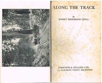
Book - ALEC H CHISHOLM COLLECTION: BOOK ''ALONG THE TRACK'' BY ROBERT HENDERSON CROLL
Book. ALEC H CHISHOLM COLLECTION. 158 page hardback with a pale green cover. An illustrated anthology of the Australian landscape by Robert Henderson Croll. Comprises a series of articles about trekking through the Australian bush, mainly in Victoria. Includes 7 Band W photos. Published c1930 by Robertson & Mullins Ltd., Melbourne and printed by Ebenezer Baylis & Son Lt., Worcester, England. Handwritten in ink on the flyleaf ''A. H. Chisholm A good companion along the track. Regards R. H. Croll''Robert Henderson Crollbooks, collections, australiana, alec h chisholm collection, robert henderson croll, bush walking, australiana -
 Bendigo Historical Society Inc.
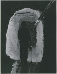
Photograph - CENTRAL DEBORAH MINE, 1951 ?
black and white photo: Alfred ( Tim ) Yates ? Walking down a mine tunnel with light in hand. Male figure in tunnel carrying lamp, tracks for carts on ground, pipes on wall at right. On back Mng 47. ' miner walking along drive at Central Deborah 1951' James Lerk 26.22.1999 ' miner assumes to be Alfred ( Tim ) Yates'organization, business, central deborah mine -
 Bendigo Historical Society Inc.
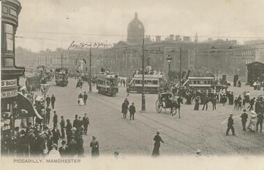
Postcard - GLADYS DEAN COLLECTION: POSTCARD, 1906 - 1908
Black and white photographic postcard. Image is of a street scene in Picadilly Manchester with a 1cm white border along the bottom edge. Image depicts a street with many trams travelling along tracks, horses, a horse drawn carriage and many people standing or walking along or across the road. Buildings are in the fore and backgrounds. The words Piccadilly, Manchester are printed in the border on the left hand side and someone has handwritten the words 'here it is again' above some marks around a statue in the distance. The reverse is blank.R Hildescheimer & Co Manchesterpostcard -
 Bendigo Historical Society Inc.
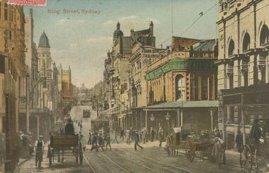
Postcard - GLADYS DEAN COLLECTION: POSTCARD, 1906 - 1908
Photographic coloured postcard. Image depicts a busy city street with tram tracks down the centre, horse and carts travelling along and people walking along or crossing the road. Many buildings line both sides of the street. The words King Street Sydney are printed in red on the top left hand side.95717postcard -
 Bendigo Historical Society Inc.
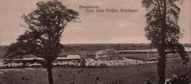
Postcard - BASIL WATSON COLLECTION: BROOKLANDS RACE TRACK
black and white postcard. On top of card ' Brooklands, View from Public Enclosure' Image taken from the perspective of the public enclosure. Two trees in foreground, people walking. Racetrack in background, pavilions visible.Valentine's Series, printed in Great Britainevent, sports, brooklands motor course, weybridge, uk -
Whitehorse Historical Society Inc.
Pamphlet, Yarran Dheran - walking tracks, suggested walks
... . Yarran Dheran - walking tracks, suggested walks Pamphlet Pamphlet ...Plan of Yarran Dheran with surrounding roads and suggested walks with times.Plan of Yarran Dheran with surrounding roads and suggested walks with times.Plan of Yarran Dheran with surrounding roads and suggested walks with times.yarran dheran, walks -
Whitehorse Historical Society Inc.
Map, Pocket guide to walking and wheeling in Whitehorse, 2008
Map showing walks, cycle tracks and off lead areas for dogs in Whitehorse.Map showing walks, cycle tracks and off lead areas for dogs in Whitehorse. Includes walking and cycling groups.Map showing walks, cycle tracks and off lead areas for dogs in Whitehorse. walking trails, bicycle paths, city of whitehorse -
 Southern Sherbrooke Historical Society Inc.
Information folder - Lovers Walk, Belgrave
... walk mt morton walking tracks Folder containing information ...Folder containing information pertaining to the history of Lovers Walk. Contents: -5 maps showing Rights-Of_way between Belgrave and Mt Morton, Belgrave Heights, with path of Lovers Walk indicated -2 photos, reprints of Rose postcards, showing views of Lovers Walklovers walk, mt morton, walking tracks -
 Ballarat Tramway Museum
Photograph - Black & White Photograph/s, mid to Late 1965
Set of seven Black and white photographs of the arrangements and work for the track reconstruction at the intersection of Hoddle St/Punt Rd and Bridge Road Richmond late 1965. On Kodak paper. 1420.1 - Bridge Road looking east at River St. crossover (Hawthorn bridge in distant background). Tram-bus connection at a weekend. Note driver's uniform. Conductor walking to bus with passengers. Conductors often worked through on the bus and next tram at this time to save crews. 1420.2 - Bridge Road at Punt Rd and Hoddle St. intersection looking north west. Reconstruction of curves. Would probably be a Sunday given that new rails are in situ. 1420.3 - Ditto - looking south east 1420.4 - looking south east 1420.5 - looking east - replacement bus service passing with old cable winding house in the background. Concrete being placed. 1420.6 - Wellington Parade at Simpson St. crossover looking east. Bus-tram connection. Bus 542 and tram 966 (Kew Depot) 1420.7 - ditto - bus 570 and tram 850 (Camberwell). See P.Winspur note - see data sheet for Reg. item 1418.trams, tramways, bridge road, tram - bus connections, trackwork, mmtb, tram 939, tram 966, tram 850