Showing 1122 items
matching waterway
-
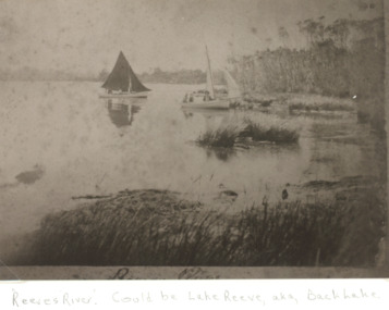 Lakes Entrance Historical Society
Photograph, Cunninghame Arm Lakes Entrance Victoria, 1900 c
Sepia toned photograph copied from a postcard showing two sailing boats at the shore of a lake. Shore edged with reeds in front of dense scrub and teatree. Reeves River later Cunninghame Arm Lakes Entrance Victoria.Also a sepia toned copy of photograph of four dwellings near waterway dense bracken fern in foreground, may be early Lakes Entrance waterways -
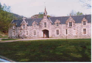
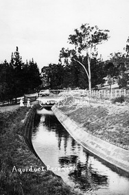 Eltham District Historical Society Inc
Photograph, Tom Prior, Maroondah Aqueduct, Research, Vic, c.1895
Built for opening in 1891 to take water from Maroondah to Reservoir. Part of a slide show presentation "Bridges & Waterways of the Shire" by Russell Yeoman to the 13 September 1989 Society meeting. The presentation included slides of historic photos from the Shire of Eltham Pioneers collections as well as several recent views.This photo forms part of a collection of photographs gathered by the Shire of Eltham for their centenary project book,"Pioneers and Painters: 100 years of the Shire of Eltham" by Alan Marshall (1971). The collection of over 500 images is held in partnership between Eltham District Historical Society and Yarra Plenty Regional Library (Eltham Library) and is now formally known as the 'The Shire of Eltham Pioneers Photograph Collection.' It is significant in being the first community sourced collection representing the places and people of the Shire's first one hundred years. The Reynolds family were early settlers in Research. The Reynolds/ Prior collection of photographs were taken by Tom Prior, the maternal uncle of Ivy Reynolds, around 1900 and the 60 photos in the album give a fine overview of many of the landmarks of Research and Eltham over 100 years ago. lvy lived in the family home for many years at 106 Thompson Cres Research. Ivy's father, Ernst Richard Reynolds and grandfather, Richard Reynolds, lived at the same address. Ivy's father Richard worked for Mr. Trail on his property in Research. Reynolds Road is named after the family. Mr Tom Prior (wife Eva) worked at the Melbourne zoo. He was very innovative and made his own camera, using the black cloth hood to exclude the light. The photographs are a reminder of the rural nature of Research and Eltham and its rich heritage.Digital image (Neg copy missing)shire of eltham pioneers photograph collection, research (vic.), maroondah aqueduct, aqueduct, reynolds prior collection -
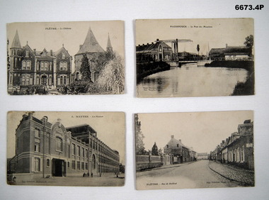 Bendigo Military Museum
Postcard - POSTCARDS, PHOTOGRAPHIC, C.1914 - 18
Photographs of regional towns in Northern France that were sites of important battles in WW1 and WW2. Both towns are locations of Military Cemeteries.1. B & W photo of French Chateau in Fletre, Flanders, France. 2. B & W photo of Hazebrouck- Le Pont De Meuniers. A waterway in Northern France. 3. B & W photo of Hazebrouck - Watten- La Filature Carts Theatre in Northern France. 4. B & W photo of Fletre - Rue De Bailleul - Street of town in Northern France.1. Headed Fletre - La Chateau. 2. Headed Hazebrouck - Le Pont Des Meuniers. 3. Headed 3. Watten - La Filature. At bottom Imp. Gobrecht Hazebrouck. 4. Bottom - Fletre - Rue De Baillel and Imp Gobrecht Hazebrouck.passchendaele barracks trust, postcards, flanders -
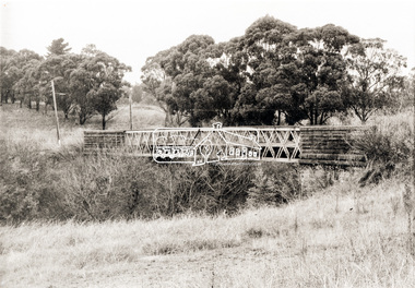 Eltham District Historical Society Inc
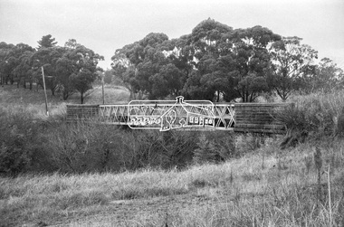
Photograph, Old Lower Plenty Bridge, c.1970
Old bridge across the Plenty River at Lower Plenty now part of the Plenty River Trail. Part of a slide show presentation "Bridges & Waterways of the Shire" by Russell Yeoman to the 13 September 1989 Society meeting. The presentation included slides of historic photos from the Shire of Eltham Pioneers collections as well as several recent views.Black and white photographmain road, plenty river, bridge, lower plenty, plenty river trail -
 Eltham District Historical Society Inc
Negative - Photograph, Russell Yeoman, Old Lower Plenty Bridge, c.1970
Old bridge across the Plenty River at Lower Plenty now part of the Plenty River Trail. Part of a slide show presentation "Bridges & Waterways of the Shire" by Russell Yeoman to the 13 September 1989 Society meeting. The presentation included slides of historic photos from the Shire of Eltham Pioneers collections as well as several recent views.Roll of 35mm black and white negative film, 4 of 7 stripsIlford HP4bridge, lower plenty, main road, plenty river, plenty river trail -
 Lakes Entrance Historical Society
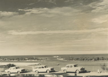
Photograph - Views from Jemmys Point, Lakes Entrance c1960, 1960 c
Black and white photograph of the entrance taken from a bend in the Princes Highway showing three cars parked at the viewing area beside the highway. Boat and dredge in waterway below highway dredged sand in Bullock Island extension, dredge Mathew Flinders working outside the entrance Lakes Entrance Victoria. Also two black and white photographs taken of Entrance from Jemmys Point taken 1960 c waterways, vehicles, islands, roads and streets -
 Eltham District Historical Society Inc
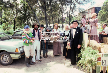
Photograph, Grand Parade, Eltham Community Festival, 17 Nov. 1984
The Society again arranged a float for the festival parade. Members dressed appropriately to the theme "Pioneers of Eltham". The parade commenced at 12 noon, participants assembling at 11.30am in Cecil Street. As in past parades, several members of the Victorian Folk Music Club accompanied the Society. The Society also arranged a display at the Eltham Community Centre in association with the activities there over the Festival weekend. The theme of this year's display was the waterways of the local area.35mm colour positive transparency Mount - Kodak Kodachrome Cardeltham, eltham festival, parade, parade floats, central park, doug orford, eltham shire office, garnet burges, joh ebeli, opal smith, panther place, peter bassett smith, peter bassett-smith, russell yeoman, victorian folk music society -
 Melbourne Tram Museum
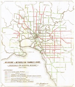
Document - Photocopy, "MMTB Proposals for General Scheme, c1970
Colour photocopy of a MMTB drawing titled "MMTB Proposals for General Scheme showing a detail plan of tramways proposed for Melbourne 1923. Signed by J. Strickland 27-8-1923. Shows cable trams, existing tramways, authorised tramways, proposed, VR tramways, rail lines and waterways. Not known when colour copy actually made - could have been an AETA or a TMSV reproduction. See Reg Item 2089 for an original of this document.trams, tramways, mmtb, melbourne, cable trams, electric trains, tramways, proposals, planning -
 Clunes Museum
Photograph, UNKNOWN
1.2. COLOUR PHOTOGRAPHS CLUNES CASTLE. HOME OF SIR DONALD CAMERON OF LOCHEIL. 3.4. COLOUR PHOTOGRAPHS CLUNES STABLES. 5. " " CLAN CAMERON MUSEUM IN GROUNDS OF CLUNES 6.COLOUR PHOTOGRAPH PART OF EXTENSIVE WATERWAYS ON THE ESTATE. THE FISHING RIGHTS OF WHICH ARE LET OUT TO THE BISSET SALMON COMPANY IN UK. 7.COLOUR PHOTOGRAPH OF DONALD YOUNGER SON LOCHIEL WITH DR. IAN CAMERON AT CLUNES HOUSE IN SCOTLAND SCANNED COPIES OF ALL THESE ARE IN THE IMAGES FOLDERlocal history, photography, photographs, cameron, donald -
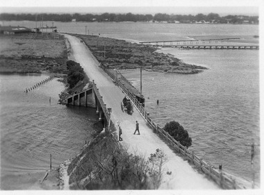 Lakes Entrance Historical Society
Postcard - North Arm bridge Lakes Entrance Victoria, 1917c
Also sepia toned photographic print 10cmx15cm, good condition old cat No 310 or 318? (Club Hotel and Hummocks area cropped from top) also Black and white photographic print 12.5cmx18cm, good condition- 2 copies 'Original T-Beam bridge opened Sept 1917 on reverse P01151-3.Black and white photographic miniature postcard showing the concrete bridge over the North Arm, showing the extended abutments, and shortened bridge length compared to previous bridge, causing restriction of waterway. Two walkers and horse drawn vehicle, buggy, on bridge. Remaining piles of wooden bridge upstream of bridge, telegraph poles upstream of bridge and across mudflats. Bridge to Bullock Island from mudflat, Club Hotel, Cunninghame Arm, and sand hummocks in distance. Lakes Entrance Victoriabridges, waterways, coast, transport, hotels -
 Eltham District Historical Society Inc
Photograph, Fay Bridge, Flood damage at Nillumbik Medical Centre, 1078 Main Road, Eltham, 26 December 2011
Flood damage resulting from a late afternoon storm on Christmas Day 2011. A flash flood occurred from significant rain fall and hail, which accumulated along an old waterway with floodwater submerging cars along Valonia Drive then down Grove Street flooding houses, through the Bible Street Reserve where it then submerged Main Road washing away the small railway trestle bridge opposite the reserve then flooding the Judge Book Village before finally entering the Diamond Creek..fay bridge collection, 2011-12-26, bible street reserve, flood damage, floods, floodwater, main road, nillumbik medical centre -
 Eltham District Historical Society Inc
Negative - Photograph, New bridge at Hurstbridge, 1917
The newly constructed re-inforced concrete arched bridge across the Diamond Creek at Hurstbridge designed by John Monash. Eltham Shire shared the cost of the construction of the bridge with Heidelberg and Whittlesea Shires. The bridge was officially opened on 3rd November 1917. Part of a slide show presentation "Bridges & Waterways of the Shire" by Russell Yeoman to the 13 September 1989 Society meeting. The presentation included slides of historic photos from the Shire of Eltham Pioneers collections as well as several recent views.This photo forms part of a collection of photographs gathered by the Shire of Eltham for their centenary project book, "Pioneers and Painters: 100 years of the Shire of Eltham" by Alan Marshall (1971). The collection of over 500 images is held in partnership between Eltham District Historical Society and Yarra Plenty Regional Library (Eltham Library) and is now formally known as 'The Shire of Eltham Pioneers Photograph Collection.' It is significant in being the first community sourced collection representing the places and people of the Shire's first one hundred years.Digital image 4 x 5 inch B&W Negshire of eltham pioneers photograph collection, hurstbridge, bridge, 1917, diamond creek (creek), monash bridge -
 Surrey Hills Historical Society Collection
Book, A History of Camberwell, 1964
Includes description including photographs of Camberwell Junction and Burke Road, pre 1950's era. Electric transport 1916-1925, tools and waterways. Published [Brisbane] : Jacaranda Press in association with the Camberwell City Council, 1964 From estate of Ken Hall; Cheryl Poustie was Ken's daughter. Records in detail history and development of the Melbourne suburb of Camberwell. A city covering thirteen square miles. Begins with first European settlement in 1835 by John Gardiner - ending at 1960.Records in detail history and development of the Melbourne suburb of Camberwell. A city covering thirteen square miles. Begins with first European settlement in 1835 by John Gardiner - ending at 1960.Title Page: Kenneth T.Hall / 89-4418camberwell - history, (mr) john gardiner, outer circle railway, camberwell (vic) - history, broughton hall -
 Eltham District Historical Society Inc
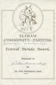
Document - Award Certificate, Eltham Community Festival, Festival Parade Award Presented to Eltham Historical Society for The Most Photogenic Entry, 1984
1984: 17 November. “Pioneers of Eltham” The Society arranged a float for the Festival parade with members dressed appropriately to the theme "Pioneers of Eltham". Participants assembled at 11.30am in Cecil Street with the parade commencing at 12 noon. As in past parades a number of members of the Victorian Folk Music Club accompanied the float and members, the group greatly added to the occasion with their happy music. The Society also arranged a display at the Eltham Community Centre in association with the activities there over the Festival weekend. The theme of the display was waterways of the local area.1984, award, eltham community festival, eltham festival, festival parade award, grand parade, shire of eltham historical society -
 Eltham District Historical Society Inc
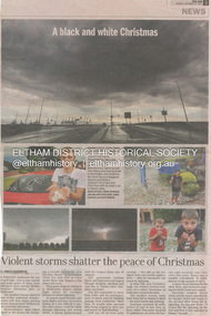
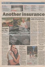
Newsclipping, Vince Chadwick, Violent storms shatter the peace of Christmas, The Age, Monday, December 26, p3, 2011
A late afternoon storm on Christmas Day 2011. A flash flood occurred from significant rain fall and hail, which accumulated along an old waterway with floodwater submerging cars along Valonia Drive then down Grove Street flooding houses, through the Bible Street Reserve where it then submerged Main Road washing away the small railway trestle bridge opposite the reserve then flooding the Judge Book Village before finally entering the Diamond Creek. Widespread damage occured from hail and flash flooding.fay bridge collection, 2011-12-26, eltham, flood damage, floods, grove street, main road, valonia drive -
 Eltham District Historical Society Inc
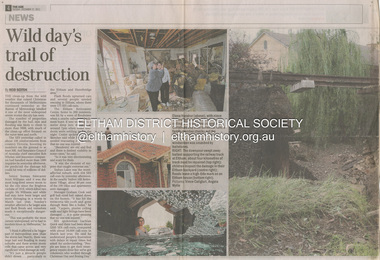
Newsclipping, Reid Sexton, Wild day's trail of destruction, The Age, Tuesday, December 27, pp4-5, 2011
A late afternoon storm on Christmas Day 2011. A flash flood occurred from significant rain fall and hail, which accumulated along an old waterway with floodwater submerging cars along Valonia Drive then down Grove Street flooding houses, through the Bible Street Reserve where it then submerged Main Road washing away the small railway trestle bridge opposite the reserve then flooding the Judge Book Village before finally entering the Diamond Creek. Widespread damage occured from hail and flash flooding.fay bridge collection, eltham, 2011-12-27, flood damage, floods, floodwater -
 Eltham District Historical Society Inc
Newsclipping, Angus Thompson et al, Another insurance storm brews, Herald Sun, Tuesday, December 27, pp4-5, 2011
A late afternoon storm on Christmas Day 2011. A flash flood occurred from significant rain fall and hail, which accumulated along an old waterway with floodwater submerging cars along Valonia Drive then down Grove Street flooding houses, through the Bible Street Reserve where it then submerged Main Road washing away the small railway trestle bridge opposite the reserve then flooding the Judge Book Village before finally entering the Diamond Creek. Widespread damage occured from hail and flash flooding.fay bridge collection, eltham, 2011-12-27, flood damage, floods, floodwater -
 Eltham District Historical Society Inc
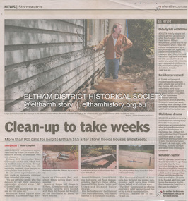
Newsclipping, Shaun Campbell, Clean-up to take weeks, Diamond Valley Leader, December 2011
A late afternoon storm on Christmas Day 2011. A flash flood occurred from significant rain fall and hail, which accumulated along an old waterway with floodwater submerging cars along Valonia Drive then down Grove Street flooding houses, through the Bible Street Reserve where it then submerged Main Road washing away the small railway trestle bridge opposite the reserve then flooding the Judge Book Village before finally entering the Diamond Creek. Widespread damage occured from hail and flash flooding.fay bridge collection, eltham, flood damage, floods, floodwater -
 Eltham District Historical Society Inc
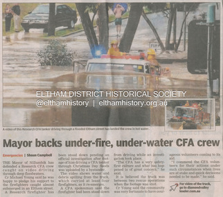
Newsclipping, Shaun Campbell, Mayor backs under-fire, under-water CFA crew, Diamond Valley Leader, December 2011
A late afternoon storm on Christmas Day 2011. A flash flood occurred from significant rain fall and hail, which accumulated along an old waterway with floodwater submerging cars along Valonia Drive then down Grove Street flooding houses, through the Bible Street Reserve where it then submerged Main Road washing away the small railway trestle bridge opposite the reserve then flooding the Judge Book Village before finally entering the Diamond Creek. Widespread damage occured from hail and flash flooding.fay bridge collection, eltham, flood damage, floods, floodwater, main road, research fire brigade -
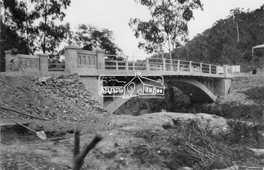
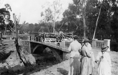
 Eltham District Historical Society Inc
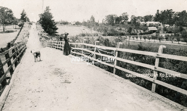
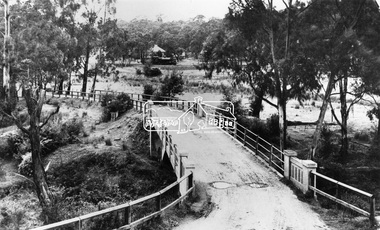
Photograph, Bridge over the Diamond Creek, Greensborough Road, Eltham, c.1885
Original (1874) bridge in Bridge Street, Eltham looking east over the Diamond Creek towards Maria Street (Main Road) at Little Eltham. In the distance to the right on Maria Street is the Methodist Church (1881), now Uniting Church, and the adjacent Commercial Bank of Australia branch building (1878). Part of a slide show presentation "Bridges & Waterways of the Shire" by Russell Yeoman to the 13 September 1989 Society meeting. The presentation included slides of historic photos from the Shire of Eltham Pioneers collections as well as several recent views.Photo of original 1875 timber and gravel surface bridge over the Diamon Creek in Bridge Street with views of orchards representative of the farming lands as well as the development along the northern end of Maria Street.Black and white photograph copybridge street, bridge street bridge, cba bank, diamond creek (creek), eltham, little eltham, main road, maria street, methodist church, uniting church -
 Eltham District Historical Society Inc
Negative - Photograph, View across bridge at Hurstbridge, Vic, c.1922
View across the new Monash bridge across the Diamond Creek at Hurstbridge looking towards the township, note steam train in centre background of image. Dated between the opening of bridge Nov. 1917 and provision of electric rail service Aug. 1926 - c.1922. Part of a slide show presentation "Bridges & Waterways of the Shire" by Russell Yeoman to the 13 September 1989 Society meeting. The presentation included slides of historic photos from the Shire of Eltham Pioneers collections as well as several recent views.This photo forms part of a collection of photographs gathered by the Shire of Eltham for their centenary project book ,"Pioneers and Painters: 100 years of the Shire of Eltham" by Alan Marshall (1971). The collection of over 500 images is held in partnership between Eltham District Historical Society and Yarra Plenty Regional Library (Eltham Library) and is now formally known as 'The Shire of Eltham Pioneers Photograph Collection.' It is significant in being the first community sourced collection representing the places and people of the Shire's first one hundred years.Digital image 4 x 5 inch B&W Negshire of eltham pioneers photograph collection, hurstbridge, bridge, steam train, diamond creek (creek), railway line, monash bridge -
 Bendigo Historical Society Inc.
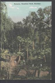
Postcard - FERNERY, ROSALIND PARK, BENDIGO
colour postcard: Fernery, Rosalind park, Bendigo. Image shows Fernery in Rosalind Park, Bendigo. Lush foliage, including tree ferns, taller eucalypt trees in background. 4 children in foreground, one standing on bridge over waterway. On rear written in black pen: ' this is a good one of the Park, don't you think - I suppose you remember when we went there - With love, May.' Addressed to Miss E M Dahlsen, Nicholson Street, Bairnsdale. Stamp has Victoria, One penny, printed.bendigo, parks and gardens, fernery, rosalind park, bendigo, fernery, rosalind park -
 Eltham District Historical Society Inc
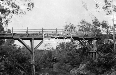
Photograph, Hurst's Bridge, c.1912
The area of Hurstbridge was originally known as Hurst’s-bridge after the timber bridge built over the Diamond Creek near Hurst’s station in late 1881/early 1882 on Hurstbridge-Arthurs Creek Road, Hurstbridge. It was built by John McDonald, of Arthur's Creek and was demolished and replaced in 1917 by a reinforced concrete arch bridge designed by John Monash. Part of a slide show presentation "Bridges & Waterways of the Shire" by Russell Yeoman to the 13 September 1989 Society meeting. The presentation included slides of historic photos from the Shire of Eltham Pioneers collections as well as several recent views. This photo forms part of a collection of photographs gathered by the Shire of Eltham for their centenary project book, Pioneers and Painters: 100 years of the Shire of Eltham" by Alan Marshall (1971). The collection of over 500 images is held in partnership between Eltham District Historical Society and Yarra Plenty Regional Library (Eltham Library) and is now formally known as 'The Shire of Eltham Pioneers Photograph Collection.' It is significant in being the first community sourced collection representing the places and people of the Shire's first one hundred years.Digital imageshire of eltham pioneers photograph collection, 1912, bridge, diamond creek (creek), hurstbridge, hurst's bridge -
![Wal Ives & Bert [Watson] at the outlet of the Kew Main Drain](/media/collectors/550653872162f11fb04854aa/items/61593ef27608a87f688412b1/item-media/61594a5a7608a87f68848c29/item-fit-380x285.jpg) Kew Historical Society Inc
Kew Historical Society IncPhotograph - Wal Ives & Bert [Watson] at the outlet of the Kew Main Drain, c.1900
Connor's Creek is/was one of two major waterways bisecting Kew, both of which empty into the Yarra River. Connor's Creek originates near the grounds of Genazzano FCJ College, which is one of the highest points in Kew. Until the 1930s, this was an open creek until a barrel drain - the Kew Main Drain - was constructed. As the creek ran through Kew it cut across a number of roads the maintenance of which was a continuing concern for Kew Councillors. In August 1864, the Council called for tenders to erect a stone culvert and embankment over Connor's Creek, on Belford-road. This may be the embankment on which the boys are sitting.Original, small photographic positive on card of two boys, identified by the donor as 'Wal Ives and Bert' [Albert Watson] sitting on bluestone capping above an outlet of Connor's Creek. To the left of the boys is a barrel drain which at that stage was the outlet for Connor's Creek near the Yarra River. The retaining wall is constructed of brick. In ink on photo: "Wal & Bert"connors creek -- kew (vic), wal ives, albert watson, belford road, yarra river -- kew (vic.), creeks -- kew (vic.), drains -- kew (vic.) -
 Sunbury Family History and Heritage Society Inc.
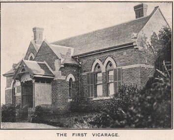
Photograph, 'Priorswood' Vicarage
The grand home is the first Church of England vicarage, 'Priorswood' to be built in Sunbury. It was sited at the east end of Station Street on Vicarage Hill and about a kilometre from St. Mary's Church in O'Shanassy Street. The distance between the two buildings presented a problem especially when the vicar had to negotiate a natural waterway across the lower end of Station Street after heavy rain. In 1914 a new Federation style vicarage was built adjacent to the church in O'Shanassy Street and was replaced in the 1960s with a more modern building, which was demolished in the 2020s to make way for 8 Oaks Community Centre.'Priorswood' is now a private home and has a local heritage listing.A print of a non-digital black and white photograph of a Gothic style brick home with a slate roof.'priorswood' vicarage, st. mary's church of england., sunbury, vicarages -
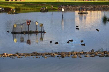 City of Ballarat
Artwork, other - Public Artwork, Home by Chris Mether, 2014
Home is a collection of birdhouses on floating islands using the iconic form of the human house - a pitched roof, square walls, windows and doors. This minimal form is often drawn by children; a dolls house, a cubby house, a letter-box or a chook house. Home creates a safe refuge for birds with the plants acting as a water filtration system. The exposed roots draw out pollutants, such as nitrogen, phosphorous and toxic metals, which have entered the waterway through urban run-off. The result is a beautiful sculptural experience and a healthier water system for all to enjoy. The artwork was funded by The City of Ballarat and The Victorian State Government.The work is of aesthetic significance to the people of BallaratHome is a collection of birdhouses on floating islands home, chris mether, studio mether, public art, ballarat, delecombe, wetlands -
 Lakes Entrance Historical Society
Photograph - Bullock Island Lakes Entrance, M Holding, 1988 c
Kalimna Heights showing development on Bullock Island including Pecks Factory. The Club Spit of dredged sand is acquiring vegetation. April Hamer dredge moored at Port Jetty, new bridge in place Lakes Entrance VictoriaAlso two colour photographs showing dumped sand on Bullock Island taken from Princes Highway lower parking bay June 2000. Donor L P Newspaper number 04209.1 size 10 x 15 cm and 04209.2 size 10 x 15 cm|Two colour photographs of Gippsland Ports Facilities taken from waterway numbers 04208.3 and 04208.4 size 10 x 15 cmColour photograph taken from Kalimna Heights showing development on Bullock Island including Pecks Factory. The Club Spit of dredged sand is acquiring vegetation. April Hamer dredge moored at Port Jetty, new bridge in place Lakes Entrance Victoriaislands, waterways, gippsland lakes -
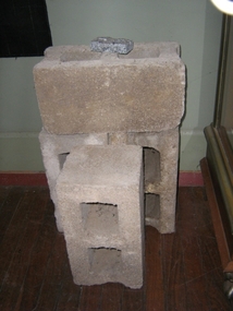 Harcourt Valley Heritage & Tourist Centre
concrete blocks, 1914
Charles Seelenmeyer conducted Concrete Utilities Limited (Harcourt Cement Pipe Factory). Operated in Harcourt circa 1914 to 1930 in premises situated opposite the ANA Hall on what is now the road reserve. Principal raw material was sand from the adjacent waterway ( Barkers Creek.) Principal output was concrete drainage tiles for use in district orchards but concrete blocks were also produced for construction of homes and commercial buildings. At a time of rapid expansion of the orchards this industry provided a vital piece of orchard infrastructure, mostly buried and not now visible but nevertheless a very important feature of the valley’s horticultural industry.. Homes built with these concrete blocks are a distinct part of Harcourt’s housing stock. Harcourt Cement Pipe Co was an example of local initiative to solve a local problem using local materials. A collection of 4 concrete building blocks -
 University of Melbourne, Burnley Campus Archives
Plan, Albert Park, c.1994
Plans of sections of Albert Park by The Hassell Group, Lead Consultant Land Systems EBC, Melbourne Parks & Waterways. 1 copy laminated of each of: (1) 2 copies Albert Park Golf Course Proposal. (2) Ross Gregory Drive Precinct. (3) Lakeside Drive May 1994. (4) 2 copies New South Melbourne Soccer Ground. (5) 2 copies Aughtie Drive. (6) 2 copies Aughtie Drive Precinct. (7) 2 copies New Home for South Melbourne Cricket Club. (8) Final Proposed Strategy Plan: Realising the Vision, coloured, Key features of the plan on reverse. -
 Eltham District Historical Society Inc
Negative - Photograph, Opening of the new bridge at Hurstbridge, 1917
The opening ceremony of new the bridge over the Diamond Creek at Hurstbridge, designed by Sir John Monash. The single arch concrete bride replaced the original wooden structure erected in 1881. People gathering around 3pm for the Official Opening of Hurst's Bridge, 3 November 1917. View of steam train at Hurstbridge Railway Station in distance. Part of a slide show presentation "Bridges & Waterways of the Shire" by Russell Yeoman to the 13 September 1989 Society meeting. The presentation included slides of historic photos from the Shire of Eltham Pioneers collections as well as several recent views. 1917 'HURST'S BRIDGE.', Eltham and Whittlesea Shires Advertiser and Diamond Creek Valley Advocate (Vic. : 1917 - 1922), 9 November, p. 3. (MORNING.), viewed 28 Jul 2018, http://nla.gov.au/nla.news-article57641838This photo forms part of a collection of photographs gathered by the Shire of Eltham for their centenary project book,"Pioneers and Painters: 100 years of the Shire of Eltham" by Alan Marshall (1971). The collection of over 500 images is held in partnership between Eltham District Historical Society and Yarra Plenty Regional Library (Eltham Library) and is now formally known as the 'The Shire of Eltham Pioneers Photograph Collection.' It is significant in being the first community sourced collection representing the places and people of the Shire's first one hundred years.Digital image 120 format B&W negativesepp, shire of eltham pioneers photograph collection, diamond creek, hurstbridge, wattle glen, bridge, mia mia, opening day, sir john monash