Showing 450 items
matching yarra river -- kew
-
 Kew Historical Society Inc
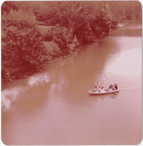
Photograph - Historic re-enactment during the Festival of Kew, 1978
... in surveying the Yarra River as far as Kew in February 1803... River as far as Kew in February 1803. The location for the event ...At the 1978 Festival of Kew, a number of organisations, including the City of Kew, the Kew Historical Society, Trinity Boys Grammar School and local Girl Guides participated in a re-enactment of the expedition of the party of Charles Grimes in surveying the Yarra River as far as Kew in February 1803. The location for the event was Yarra Bend Park near the Studley Park Boat House. The event was organised by the Kew Historical Society. The re-enactment was captured by a number of amateur photographers as well as by a photographer from the local Progress Press.Local communities select events to commemorate according to their shared history and values. Commemorations of colonial exploration were popular with local historical groups such as the Kew Historical Society in the twentieth century. In re-enacting events such as the Grimes survey of the Yarra, students from a local school were encouraged to take on specific roles, including play-acting individuals involved in the survey party as well as members of the local Wurundjeri People. The photographs, taken by amateur and professional photographers, represent a period in time when the dominant values were those shared by the descendants of European settlers in Victoria. Original colour photographic positive of six students from Trinity Grammar School, dressed in period costume, enacting in 1978 the arrival of the surveyor Charles Grimes at Studley Park in 1803. Annotated on reverse: "BOAT CREW / TRINITY BOYS AS GRIMES PARTY / 1978"kew historical society, trinity grammar school, kew girl guides, city of kew, yarra river, charles grimes, collins expedition, wurundjeri people, yarra bend park, colonial surveys, historic re-enactments, festival of kew, kew festival -
 Kew Historical Society Inc
Photograph, Chipperfield's Boat House & Floating Pontoon, 1934
... sides of the River Yarra at Kew. Chipperfield's Boat House... sides of the River Yarra at Kew. Chipperfield's Boat House ...Living with natural processes was frequently a challenge to early European settlers and later residents of what was in the 1850s administered by the Borondara Road Board. This was compounded by the area being bounded on three sides by rivers (Yarra River, Koonung Creek and Gardiner's Creek). In 1849, the historian James Bonwick recorded that "our district [Kew] suffered considerably. Mr Wade speaks of 80 acres, out of 100 acres of his cultivated paddock, covered by water." Newspapers continued to describe major flooding in Kew in 1863, 1869, 1878, 1880, 1889, 1891, 1916 and 1934. While the construction of the Upper Yarra dam in 1957 reduced the levels of flowing downstream, local and riverine floods continue. A number of boat houses operated on both sides of the River Yarra at Kew. Chipperfield's Boat House was located on the Yarra near the corner of Kilby and Willsmere Roads.The Kew Historical Society's pictures and map collections testify to the impact of flooding in the district. They have historical importance in documenting the extent of flooding in the district and its affects on homes, services and recreation. Numerous photographs record flooding throughout the Twentieth Century.Floating pontoon at Chipperfield's Boat House where the canoes were stored, taken in 1934, presumably before the 1934 Flood. This area of the Yarra was shallow with a number of mid river sandbanks and a popular swimming area for locals.yarra river, chipperfield's boathouse, pontoon -
 Mission to Seafarers Victoria
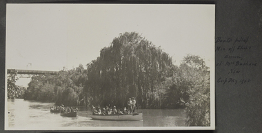
Photograph - Photograph, Sepia, Boat Full of Men off Ships arriving at Mrs Buchan, Kew, Cup Day 1928 (6 Nov. 1928), 6 November 1928
Mr and Mrs Buchan organised many picnics on the ground of their house Finhaven, Kew.on page 11finhaven, kew, mr john inerrarity buchan, cup day, wooden boat, picnic, lhlg, yarra river, reverend weller, fan album, social events -
 Ballarat Heritage Services
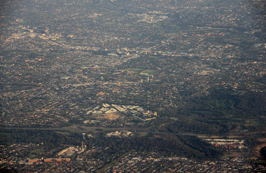
Photograph - Digital photographs, L.J. Gervasoni, Kew and Hawthorn from the air, c2017
... melbourne aerial cityscape landscape kew yarra river aerial ...Digital images of the Melbourne suburb od Kew and Hawthorn from the air.hawthorn, camberwell, kew junction, eastern freeway, camberwell junction, glenferrie, kew cottages, willsmere, melbourne, aerial, cityscape, landscape, kew, yarra river, aerial photograph -
 Kew Historical Society Inc
Plan - Subdivision Plan, H C Crouch, Old Golf Links Estate, 1930s
The land in North Kew between the Outer Circle Railway and the River Yarra was released in sections. This release included 80 lots. Most of this area was released during the Depression years in the early 1930s.Subdivision plans are historically important documents used as evidence of the growth of suburbs in Australia. They frequently provide information about when the land was sold on which a built structure was subsequently constructed as well as evidence relating to surveyors and real estate and financial agents. The numerous subdivision plans in the Kew Historical Society's collection represent working documents, ranging from the initial sketches made in planning a subdivision to printed plans on which auctioneers or agents listed the prices for which individual lots were sold. In a number of cases, the reverse of a subdivision plan in the collection includes a photograph of a house that was also for sale by the agent. These photographs provide significant heritage information relating house design and decoration, fencing and household gardens.One part of a massive subdivision of the Old Golf Links Estate in North Kew of 80 allotments bordering Sutherland Avenue, Ramsay Avenue, Belford Road, Beresford Street and Coleman Avenue. Inset on the plan at the top left, the route of the Outer Circle Railway is clearly marked. The Kew Golf Links is identified in its current location. The land on which Greenacres Golf Club was to be constructed is at this time marked as ‘Recreation Ground’. The ‘new bridge’ over the Yarra at Burke Road is also marked on the inset map. The Plan identifies the surveyor (sic) H.C. Crouch BCE MVIS, 443 Little Collins St., Melbourne. The date of the subdivision auction sale in identified as Saturday September 25th at three o'clock.Annotations: "E" top left. "Golf Links" top right. Lots 73-76 ticked and listed as "6" poundssubdivisions -- kew (vic.), old golf links estate -
 Kew Historical Society Inc
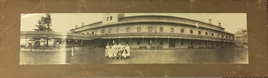
Photograph - Female Staff, Kew Hospital for the Insane, c.1929
Following a Royal Commission in 1854, the building of a new Asylum at Kew began in 1864. It was built to replace the Yarra Bend Asylum on the Fairfield side of the Yarra River. Work started in 1864 and was completed in 1872 at a cost of ₤198,334. Operating over a period of 116 years, and often renamed to take account of public sensitivities, the ‘Kew Lunatic Asylum’ was one of the largest asylums built in Australia. ‘Willsmere’ was finally closed in December 1988 and sold by the Government of Victoria in the late 1980s.A rare and historically significant photograph of female staff of the Kew Hospital for the Insane, in front of the central wing. The photograph is one of a pair donated to the Kew Historical Society by Frances Dorothea Van Brummelen (1931-2011) in 1994. Following her graduation as a social worker, Fran Van Brummelen joined the staff of Kew Cottages in 1969, and became senior social worker there in 1971. She remained at the cottages until she retired in 1994. Earlier, In 1987, with psychiatrist Cliff Judge, she founded the Kew Cottages Historical Society becoming its president. In 2002, the pair collaborated on the book Kew Cottages: the World of Dolly Stainer, which was later commended in the Victorian Community History Awards. Panoramic photograph of group of female staff in north courtyard, in front of Administrative Wingkew lunatic asylum, kew mental hospital, kew hospital for the insane, willsmere -
![Photographs [Series], Noel Kelly, Chandler Highway Bridge Construction, 11/07/2018](/media/collectors/550653872162f11fb04854aa/items/5c2f52bd21ea670d20783d9e/item-media/5c2f53b221ea670d2079233e/item-fit-380x285.jpg) Kew Historical Society Inc
Kew Historical Society IncPhotographs [Series], Noel Kelly, Chandler Highway Bridge Construction, 11/07/2018
A selection of photographs taken in July/August 2018 recording work on the old and new Chandler Highway Bridges.chandler highway bridge, noel kelly, railway viaduct - river yarra -
 Kew Historical Society Inc
Photograph, Outer Circle Railway Viaduct, 1919
Railway Viaduct constructed for the Outer Circle Railway. Bridge designed by John Monash, engineer. Converted into a state highway, 1930s.Dateable photo of an important piece of Victorian railway infrastructure.Photograph of Outer Circle Railway Bridge over River Yarra, Fairfield. Looking toward Lugton Street, showing fence underneath taken from the Chandler Highway. Reverse: "Outer Circle Railway Bridge over River Yarra Fairfield, H0276, Property of Miss Foley"railway viaduct, chandler highway -
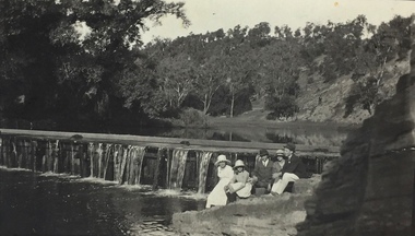 Kew Historical Society Inc
Photograph, Richardson Family at Dight's Falls, 1920
Dight’s Falls in Studley Park is an artificial weir built on a natural rock bar across the Yarra. The weir was built in the 1840s to provide water to the ‘Ceres’ flour-mill, one of the first in Victoria. The falls were later to become known as Dight’s Falls after the owners of the mill. Later, a pumping station was built on the Kew side of the river, which pumped water uphill to a reservoir in Walmer Street that provided water to the Melbourne Botanical Gardens and to Albert Park Lake. The area around Dight’s Falls was and is frequently used for recreational activities.This photograph forms part of the collection assembled by the historian Dorothy Rogers, that was donated to the Kew Historical Society by her son John Rogers in 2015. The manuscripts, photographs, maps, and documents were sourced by her from both family and local collections or produced as references for her print publications. Many were directly used by Rogers in writing ‘Lovely Old Homes of Kew’ (1961) and 'A History of Kew' (1973), or the numerous articles on local history that she produced for suburban newspapers. Most of the photographs in the collection include detailed annotations in her hand. The Rogers Collection provides a comprehensive insight into the working habits of a historian in the 1960s and 1970s. Together it forms the largest privately-donated collection within the archives of the Kew Historical Society.Black and white photograph of the Richardson family seated on the Kew side of Dight's Falls in 1920. One of the girls in the photograph was to become the Melbourne historian Dorothy (Richardson) Rogers.Annotation on reverse: "Mrs D. Rogers, 29 Park Crst Kew. Dights Falls 1920"dight's falls - kew (vic) - fairfield (vic), sport and recreation - kew (vic), dorothy rogers -
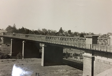
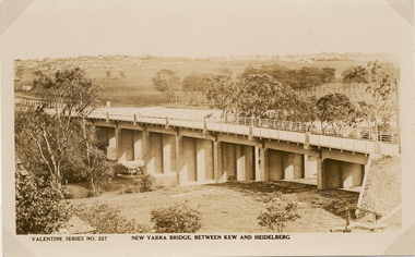 Kew Historical Society Inc
Postcard, Valentine Publishing Co Pty Ltd, New Yarra Bridge, Between Kew and Heidelberg, 1926-1930
Without bridges, Kew remained cut off from the City of Melbourne, only being accessible by Punt. Private and public bridges were constructed from the 1850s, beginning with the Hawthorn Bridge linking Bridge and Burwood Roads. A bridge across the Yarra at Burke Road was created as early as 1873. Since that first wooden bridge, a number of later bridges, typically on concrete pylons have been built, in 1926 and again during the 1970s.Angle view of the new Yarra bridge [ie. The Burke Road bridge] taken from the Kew side, showing the bridge’s structure. Trees line the river’s edge. In the distance can be seen a distant line of houses stretching to the horizon. The river appears to have an S-shaped bend beyond the bridge. The postcard, No. 227, was produced by the Valentine Publishing Co. Pty Ltd., of Queen Street, Melbourne.burke road bridge - kew (vic), bridges - kew (vic) -
 Kew Historical Society Inc
Archive (Sub-series) - Subject File, Billabong - Willsmere Park, 1958
... sources. billabong - willsmere park - kew east billabongs - yarra ...Various partiesReference, Research, InformationKHS OrderNewspaper articles/clippings relating to the desire to save the Billabong at Willsmere Park in Kew. The file includes articles with a more general focus relating to bike paths and Willsmere Park generally.billabong - willsmere park - kew east, billabongs - yarra riverbillabong - willsmere park - kew east, billabongs - yarra river -
Kew Historical Society Inc
Archive (Sub-series) - Subject File, Dight's Falls, 1958
Various partiesReference, Research, InformationSecondary Values (KHS Imposed Order)Dight’s Falls in Studley Park is an artificial weir built on a natural rock bar across the Yarra. The weir was built in the 1840s to provide water to the ‘Ceres’ flour-mill, one of the first in Victoria. The falls were later to become known as Dight’s Falls after the owners of the mill. Later, a pumping station was built on the Kew side of the river, which pumped water uphill to a reservoir in Walmer Street that provided water to the Melbourne Botanical Gardens and to Albert Park Lake. The area around Dight’s Falls was and is frequently used for recreational activities. Subject file containing sundry newspaper articles/clippings on the Mill. Also a photocopy of a brief article on Dights Mill and Falls by Jan Gross. Also an article on the Pumping Station.dight's mill, dight's falls, pumping station - yarra riverdight's mill, dight's falls, pumping station - yarra river -
Kew Historical Society Inc
Archive (Sub-series) - Subject File, Kew Historical Society, GARRYOWEN, 1958
... sources. kew historical society - archives yarra river dight's ...Various partiesReference, Research, InformationSecondary Values (KHS Imposed Order)Subject file containing typed extracts from articles by the 19th century journalist and historian, Garryowen (Edmund Finn). The document is annotated by various members of the Society at a later stage.kew historical society - archives, yarra river, dight's falls, hugh glass, gardiner's creek, george wharton, studley house - hodgson's follykew historical society - archives, yarra river, dight's falls, hugh glass, gardiner's creek, george wharton, studley house - hodgson's folly -
Kew Historical Society Inc
Archive (Sub-series) - Subject File, Kew Historical Society, GRIMES, Charles, 1962
... exploration - kew (vic) yarra river - history Charles Grimes ...Various partiesReference, Research, InformationSecondary Values (KHS Imposed Order)Charles Grimes was acting Surveyor-General of the Colony of New South Wales. He was the first European cartographer to map the lower reaches of the Yarra River. The reference file contains both research on the ‘exploration’ by Grimes as well as information on a re-enactment, sponsored by the Kew Historical Society in 1978, to mark the 175th year of his party’s arrival in the area of what is now Dight’s Falls. In the file is a 13-page handwritten document to be used as a script for a speech during the reenactment, which also includes details of the costumes to be worn. There are additional unpublished manuscripts in the file about Grimes and his ‘journey’ by Mr Chinner and Mavis Rolley. The file also includes newspaper articles/clippings as well as sundry published articles.charles grimes, commemorations - kew (vic.), european exploration - kew (vic), yarra river - historycharles grimes, commemorations - kew (vic.), european exploration - kew (vic), yarra river - history -
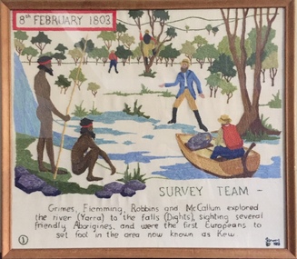 Kew Historical Society Inc
Textile - Bicentennial tapestry, 1. Survey Team, 8th February 1803, 1988
This is one of eight embroidered panels, completed during the 1988 Australian Bi-Centennial, and carried out under the auspices of City of Kew Council and the Kew Historical Society. Nearly 600 residents, including many children, participated in their production by adding a few or more stitches. A book records their names and the panels upon which they worked. Artist: Joy Stewart / Co-ordinator: Dorothy Benyei.1. Survey Team. A framed embroidery created by adults and children of the City of Kew as a Bicentennial project, based on a design by the artist Joy Stewart. Five of the six completed embroideries created in the project are/were displayed in the Kew Library. [The five embroidered panels have now been temporarily removed for conservation reasons].Inscription: "SURVEY TEAM 8th February 1803 / Grimes, Flemming, Robbins and McCallum explored the river (Yarra) to the falls (Dights), sighting several friendly Aborigines, and were the first Europeans to set foot in the area now known as Kew." Embroidered signature of the artist: "(c) JStewart, 1988"bicentennial project (kew), joy stewart, charles grimes expedition, australian bicentennial -
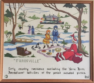 Kew Historical Society Inc
Textile - Bicentennial tapestry, 2. Turinville, 1988
This is one of eight embroidered panels, completed during the 1988 Australian Bi-Centennial, and carried out under the auspices of City of Kew Council and the Kew Historical Society. Nearly 600 residents, including many children, participated in their production by adding a few or more stitches. A book records their names and the panels upon which they worked. Artist: Joy Stewart / Co-ordinator: Dorothy Benyei.1. Turinville. A framed embroidery created by adults and children of the City of Kew as a Bicentennial project, based on a design by the artist Joy Stewart. Five of the six completed embroideries created in the project are/were displayed in the Kew Library. [The five embroidered panels have now been temporarily removed for conservation reasons].Inscription: "TURINVILLE / Early country residence overlooking the Yarra River. Recreational activities of the period included picnics" Embroidered signature of the artist: "(c) JStewart, 1988"bicentennial project (kew), joy stewart, charles grimes expedition, australian bicentennial -
 Kew Historical Society Inc
Photograph, J F C Farquhar, Railway Bridge Over the Yarra, 1891
At the beginning of the 1890s, the Kew businessman and Town Councillor, Henry Kellett, commissioned J.F.C. Farquhar to photograph scenes of Kew. These scenes included panoramas as well as pastoral scenes. The resulting set of twelve photographs was assembled in an album, Kew Where We Live, from which customers could select images for purchase.The preamble to the album describes that the photographs used the ‘argentic bromide’ process, now more commonly known as the gelatine silver process. This form of dry plate photography allowed for the negatives to be kept for weeks before processing, hence its value in landscape photography. The resulting images were considered to be finely grained and everlasting. Evidence of the success of Henry Kellett’s venture can be seen today, in that some of the photographs are held in national collections.It is believed that the Kew Historical Society’s copy of the Kellett album is unique and that the photographs in the book were the first copies taken from the original plates. It is the first and most important series of images produced about Kew. The individual images have proved essential in identifying buildings and places of heritage value in the district.Completed in November 1890, the railway viaduct (now the Chandler Highway Bridge) linked Kew and Fairfield. The viaduct is significant as the most substantial extant engineering remnant of the Outer Circle Railway Line. Opened in March 1891, the viaduct crossed the Yarra River in a single span, atop three supporting brick pillars. Following the closure of the railway line in 1927, and the construction of the Chandler Highway in 1930, the bridge was used for vehicular traffic. In 1891 when this panoramic photograph was taken, the grounds of what was then the Kew Lunatic Asylum extended down to the River and eastward beyond the viaduct. The landscape surrounding the Asylum was planted with traditional exotic trees such as Oaks, Pines and Cedars, and landmark trees from northern Australia such as the Hoop Pine. Remnant indigenous trees such as the River Red Gum, Yellow Box and Lightwood were scattered around the site, including beside the Yarra River.Railway Bridge Over the Yarrakew illustrated, kew where we live, photographic books, henry kellett, railway viaduct - - kew (vic) -
 Kew Historical Society Inc
Photograph, J F C Farquhar, Ratting on the Yarra, 1891
At the beginning of the 1890s, the Kew businessman and Town Councillor, Henry Kellett, commissioned J.F.C. Farquhar to photograph scenes of Kew. These scenes included panoramas as well as pastoral scenes. The resulting set of twelve photographs was assembled in an album, Kew Where We Live, from which customers could select images for purchase.The preamble to the album describes that the photographs used the ‘argentic bromide’ process, now more commonly known as the gelatine silver process. This form of dry plate photography allowed for the negatives to be kept for weeks before processing, hence its value in landscape photography. The resulting images were considered to be finely grained and everlasting. Evidence of the success of Henry Kellett’s venture can be seen today, in that some of the photographs are held in national collections.It is believed that the Kew Historical Society’s copy of the Kellett album is unique and that the photographs in the book were the first copies taken from the original plates. It is the first and most important series of images produced about Kew. The individual images have proved essential in identifying buildings and places of heritage value in the district.In Farquhar’s close-up portrait of the rat catcher and his dog, the photographer excludes any extraneous data that otherwise might have provided a spatial or motivational context. The contemporary or the present day viewer is required to construct a narrative to explore or understand what is occurring. The title of the picture might incline a viewer to believe that what they see is an exercise in vermin control, and that the rat concerned might be an introduced black or brown rodent. A more likely scenario is that the rat catcher is focussed on catching ‘rakali’, a native water-rat once widely trapped for its fur. The trapping of rakali for use in the manufacture of fashionable clothing accelerated as introduced furs such as musquash became more expensive. It was not until 1938 that rakali were granted protected status.Ratting on the Yarrakew illustrated, kew where we live, photographic books, henry kellett, yarra river -
 Kew Historical Society Inc
Photograph, J F C Farquhar, Dight's Falls, 1891
At the beginning of the 1890s, the Kew businessman and Town Councillor, Henry Kellett, commissioned J.F.C. Farquhar to photograph scenes of Kew. These scenes included panoramas as well as pastoral scenes. The resulting set of twelve photographs was assembled in an album, Kew Where We Live, from which customers could select images for purchase.The preamble to the album describes that the photographs used the ‘argentic bromide’ process, now more commonly known as the gelatine silver process. This form of dry plate photography allowed for the negatives to be kept for weeks before processing, hence its value in landscape photography. The resulting images were considered to be finely grained and everlasting. Evidence of the success of Henry Kellett’s venture can be seen today, in that some of the photographs are held in national collections.It is believed that the Kew Historical Society’s copy of the Kellett album is unique and that the photographs in the book were the first copies taken from the original plates. It is the first and most important series of images produced about Kew. The individual images have proved essential in identifying buildings and places of heritage value in the district.Dight’s Falls in Studley Park is an artificial weir built on a natural rock bar across the Yarra. The weir was built in the 1840s to provide water to the ‘Ceres’ flour mill, one of the earliest industrial sites in Melbourne. The falls were later to be named after the owner of this mill. In 1888, William Guilfoyle, Director of the Melbourne Botanical Gardens had called for fresh water to be piped from above the weir to the Botanical Gardens, using a pumping station on the Kew side of the Falls, a holding reservoir in Walmer Street and a series of pipes from there to the Gardens. This system was opened in May 1891. Farquhar’s photograph of the man-made weir obscures the industrial activity on both sides of the Falls and focusses solely on the river and the surrounding natural vegetation. The photograph probably predates the disastrous flooding of the Yarra River in July 1891, the greatest to have occurred in the Colony since the foundation of Melbourne.Dight's Fallskew illustrated, kew where we live, photographic books, henry kellett, yarra river -
 Kew Historical Society Inc
Photograph, J F C Farquhar, The Yarra in Hyde Park, 1891
At the beginning of the 1890s, the Kew businessman and Town Councillor, Henry Kellett, commissioned J.F.C. Farquhar to photograph scenes of Kew. These scenes included panoramas as well as pastoral scenes. The resulting set of twelve photographs was assembled in an album, Kew Where We Live, from which customers could select images for purchase.The preamble to the album describes that the photographs used the ‘argentic bromide’ process, now more commonly known as the gelatine silver process. This form of dry plate photography allowed for the negatives to be kept for weeks before processing, hence its value in landscape photography. The resulting images were considered to be finely grained and everlasting. Evidence of the success of Henry Kellett’s venture can be seen today, in that some of the photographs are held in national collections.It is believed that the Kew Historical Society’s copy of the Kellett album is unique and that the photographs in the book were the first copies taken from the original plates. It is the first and most important series of images produced about Kew. The individual images have proved essential in identifying buildings and places of heritage value in the district.Hyde Park is now a small recreation reserve bordered by Willsmere and Kilby Roads and White Avenue. In 1982, Hyde Park was cut off from the Yarra River by the construction of the Eastern Freeway. The building of the latter was to transform the natural landscape, including the Yarra, as well as Hyde Park. The construction of the Freeway makes it difficult to view the scene with the photographer’s eye. Today’s Hyde Park is located on land purchased in 1847 by John Cowell, and in 1851 Catherine Cowell, yet the scene selected by the photographer may well have been located on farmland owned by the Wills family. Farquhar’s point-of-view emphasises both the pastoral and recreational elements of the scene: the grazing cows, three boys, and in the distance two figures, seated on the bank with a parasol. By 1891, an environmental consequence of human activity, including farming, was deforestation, leading to the erosion of the south bank of the Yarra. In contrast, the land on the Alphington side of the river in 1891 included remnant bushland.The Yarra in Hyde Parkkew illustrated, kew where we live, photographic books, henry kellett, yarra river -
 Kew Historical Society Inc
Plan - Subdivision Plan, Kew Golf Links Estate, 1936, 1936
The Kew Golf Links Estate was a major subdivision in North Kew. It derived its title due to the land being previously occupied by the Kew Golf Club, which transferred its course to a number of locations before occupying its current site. The Plan advertises 180 choice home sites. The street names are somewhat different today as those on the map are named after the proposed Kodak Factory to be built on the site. The subdivision of the Kew Golf Links Estate was a major subdivision of farmland in Kew. The site was at one stage designated for industrial development and the building of a new Kodak factory. The decision by Council to oppose the redevelopment makes the beginning of the period when all industrial development was banned in Kew.Monochrome printed, folded subdivision plan for the Kew Golf Links Estate, to be auctioned on 7 November 1936. Streets named include: Carnegie Avenue, Willsmere Road, Kilby Boulevarde, Kodak Avenue, Coleman Avenue, Beresford Avenue, McConchie Avenue, Cole Avenue, White Avenue, Baker Avenue, Spruzen Avenue, Tanner Avenue, Ratten Avenue, Mathers Avenue, Railway Avenue, Sutherland Avenue, and Belford Road. The position of the Yarra River and a large Drainage Reserve are marked on the plan. Lots for sale are numbered. Existing buildings are designated with a square.subdivision plans - kew (vic), kodak factory - kew (vic) -
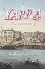 Kew Historical Society Inc
Book, Kristin Otto, Yarra: a diverting history of Melbourne's murky river, 2005
245 p. : ill., bib., index, pbk ; 24 cm.non-fictionmelbourne - history, yarra river - history -
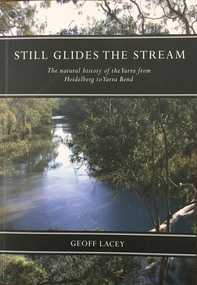 Kew Historical Society Inc
Book, Australian Scholarly Publishing Pty Ltd, Still Glides the Stream: The natural history of the Yarra from Heidelberg to Yarra Bend, 2004
... yarra river - natural history geoff lacey Natural History ...Natural History of Yarraxii, 281 p. : ill., maps ; 22 cmnon-fictionNatural History of Yarrayarra river - natural history, geoff lacey -
Kew Historical Society Inc
Book, Book Collectors' Society of Australia, Batman & Fawkner: Discovery of the River Yarra; an episode, 1965
Originally printed by H. Cordell, 59 Queen St., 1881. Limited edition of 250 copies11 p. 2 facsims. 23 cm. non-fictionOriginally printed by H. Cordell, 59 Queen St., 1881. Limited edition of 250 copiesbatman john -- 1801-1839, fawkner john pascoe -- 1792-1869, melbourne (vic.) - history - 1834-1851. -
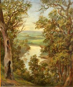 Kew Historical Society Inc
Painting, Herbert J Woodhouse, River Yarra Near Dights Falls, c.1892
... Framed oil painting on board of the River Yarra at Studley... century herbert james woodhouse (1854-1937) yarra river - studley ...Herbert James Woodhouse (1854-1937) was born in Essex and arrived in Australia with his family in 1857. A painter-lithographer like his father and three of his brothers, he was a prizewinner in the South Australian Society of Arts exhibition of 1885. He also received commendations in exhibitions at the Victorian Academy of Arts and the New South Wales Arts Society. At an exhibition of his paintings at Scott’s Hotel in Collins Street in 1892, the reviewer for Table Talk noted that the ‘artist paints almost solely in the open air, and his studies are generally carried out during the trips of the Victorian Sketching Club’. One of the paintings singled out for praise was: ‘A very effective river scene at Willsmere, aptly named A Midstream Mirror, ... a picture powerful in its effective reflection of sunlight in the river.’ Herbert Woodhouse died in Geelong in June 1937, aged 82, and was buried in the Eastern Cemetery. A number of his sketchbooks are held in the collection of the State Library of Victoria.Framed oil painting on board of the River Yarra at Studley Park, Kew, by Herbert James Woodhouse (1858-1937). The artist has framed the narrow painting with trees in the foreground and a view of the Yarra River and rolling hills in the background. Verso, written by artist: "River Yarra Near Dights Falls"australian art - 19th century, herbert james woodhouse (1854-1937), yarra river - studley park -
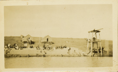 Kew Historical Society Inc
Photograph - Deep Rock Swimming Pool and Clubrooms on the Yarra, c.1925
The former Deep Rock Swimming Pool was about 500 yards [457 metres] above Dight’s Falls. It was there that the Deep Rock Swimming Club was established in 1906. This initial club was expanded in 1916 to incorporate a life-saving club. In 1918, John Wren, the president of the club offered the club £1000, and undertook to sponsor a patriotic carnival in March 1918, at which swimming champions would take part. The ‘pool’ was to achieve fame as the venue for a world record-breaking ‘swallow dive’ of 205 feet 9 inches [63 metres] by ‘Prince Wickyama’, [aka Alec Wickham], a Solomon Islander. The dive from a special platform on the west side of the Yarra was reputedly viewed by between 50,000-100,000 spectators, with funds going to the State War Council. The Herald, 25 March 1918, claimed that the wide area occupied by spectators made more precise estimates impossible. In the 1980s, the construction of the Eastern Freeway, and the consequent re-routing of the Yarra River led to the site of the Deep Rock Pool being obliterated. A small cairn and plaque on the Fairfield side of the river now marks its former site.Very rare early photograph off the Deep Rock swimming pool. The pool and its built structures are historically and socially important to the people of Collingwood, Fairfield and Kew. Small, faded, Gelatin Silver print positive photograph of the Deep Rock Swimming Pool situated on the Yarra at Collingwood and Fairfield. The famous diving tower is at the right of the photo. The built structures were constructed for the Deep Rock Swimming and Life Saving Club. People are sitting on the terraces above the river. "Bathing Club. Deep Rock on the Yarra. Studley Park Melbourne. Please credit E.J. Thomasson Collection"deep rock swimming pool, deep rock swimming club, deep rock lifesaving club, swimming -- river yarra, river yarra -
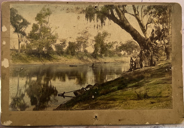 Kew Historical Society Inc
Photograph - Wurundjeri People at Studley Park
The Wurundjeri Woi Wurrung People were the original owners of the land on which the City of Boroondara is now located. They made active use of the Yarra for food and transport [an original canoe is held in the collection of the Melbourne Museum]. From 1863, members of the Wurundjeri Woi Wurrung were resettled at the Corranderrk Aboriginal reserve at Healesville. The [now] best known member of the Wurundjeri People was William Barak, who may be pictured here.If the attribution in the annotation is correct, then this may be the earliest photograph of members of the Wurundjeri People at Kew. The photo may be unique.Hand tinted photograph on mounting card of members of the Wurundjeri Woi Wurrung on the banks of the River Yarra, allegedly at Studley Park before 1855 [according to the annotation on the reverse] The photograph of the river and its near and far banks includes two boats on the river, a row boat and a canoe, and people standing on the near bank or seated on the branch of a tree. In addition to men and women of the Wurundjeri People, there appears to be two Europeans pictured, one wearing a hat and the other standing at right. Annotations on the reverse identify a [possible] location and date. [Size: Mount 140 x 215mm | Photograph 125 x 190mm]Various hands and dates: "Original lead pencil lettering Studley Yarra Yarra / Yarra Yarra Studley / Studley (Park?) / Note aboriginals in a bark canoe / Prior 1855 / Very early photo Yarra River originally known as the Yarra Yarra / [illegible part word in ink]".wurundjeri woi wurrung, yarra river, aboriginal and torres straight islander -
Kew Historical Society Inc
Journal, Kewriosity : February 1992
Kew Youth Arts Festival: 1992 [Two weeks of culture & entertainment; Photo competition; writing competition] / p1. Chief Executive's Comment [Proposal for old library area below Municipal Offices to be leased to Australia Post as a distribution centre] / Malcolm Hutchinson p2. Mayor's Comment [Kew's Old Post Office] / Cr Daryl Oldaker p3. Kew Citizen of the Year Award Australia Day 1992 [Graeme Lindsay] / p3. Diary Dates for February/March [1992] / p4. Community Directory / p4. Free sausage sizzle breakfast at the Kew Recreation Centre / p5. Spare Time? [volunteering at Kew Cottages] / p5. Kew Garden Club [photo Yvonne Knight, Alex McKay] / p5. Urban design guidelines for Lower Yarra River / p6. Nursing Mothers' Association / p6. Kew Community House - 6 Derby Street / p6. New parking signs / p7. Adult literacy [Swinburne College of TAFE Access Education Department] / p7. National Trust's Guide to Renovating Inter-War houses /p8. Row boat for disabled [Rotary Club of Kew] / p8.Kewriosity was a local newsletter combining Kew Council and community news. It was published between November 1983 and June 1994, replacing an earlier Kewriosity [broad] Sheet (1979-84). In producing Kewriosity, Council aimed to provide a range of interesting and informative articles covering its deliberations and decision making, together with items of general interest and importance to the Kew community and information not generally available through daily media outlets.non-fictionKew Youth Arts Festival: 1992 [Two weeks of culture & entertainment; Photo competition; writing competition] / p1. Chief Executive's Comment [Proposal for old library area below Municipal Offices to be leased to Australia Post as a distribution centre] / Malcolm Hutchinson p2. Mayor's Comment [Kew's Old Post Office] / Cr Daryl Oldaker p3. Kew Citizen of the Year Award Australia Day 1992 [Graeme Lindsay] / p3. Diary Dates for February/March [1992] / p4. Community Directory / p4. Free sausage sizzle breakfast at the Kew Recreation Centre / p5. Spare Time? [volunteering at Kew Cottages] / p5. Kew Garden Club [photo Yvonne Knight, Alex McKay] / p5. Urban design guidelines for Lower Yarra River / p6. Nursing Mothers' Association / p6. Kew Community House - 6 Derby Street / p6. New parking signs / p7. Adult literacy [Swinburne College of TAFE Access Education Department] / p7. National Trust's Guide to Renovating Inter-War houses /p8. Row boat for disabled [Rotary Club of Kew] / p8.publications -- city of kew (vic.), kewriosity, council newsletters, community newsletters -
Kew Historical Society Inc
Journal, Kewriosity : March 1991
Kew Festival 10th March to 24th March - Kew is for living / artwork Heike Effler / p1. Dates for March [1991] / p2. Easter hours [Council Offices] / 2. 10th April [Rates and dog registrations due] / p2. Voters' Roll / p2. [Kew] Community House events / p2. Commentary / Cr Daryl Oldaker p3. Council's casino letter [Willsmere] / p3. Later to the editor [Casino] / E Stanley Meyer p3. Information: your view [Council survey] / p2. Cotham Road rebuilt [reconstruction] / p4. Anybody home? [1991 Census] / p4. Valley views protected [development along the Yarra River] / p4. Reaching the tram [upgrades] / p5. Traffic management update [Area 4, Area 5, Area 6, Area 7, Area 10] / p5. 7,000 more Kewites [projected population growth] / p5. New school buildings [Ruyton Girls' School; Methodist Ladies' College; Trinity Grammar; Xavier College; Genazzano College; Carey Grammar School; Preshil] / p5. High St [Pedestrian] Crossing / p5. St George's amalgamated [with Victoria Parade Geriatric Centre, Henry Pride Unit, Hawthorn Day Hospital] / p6. Youth co-ordination [Youth Workers' Forum] / p6. Bowling vacancies [East Kew Bowling Club] / p6. Driver wanted [for Henry Pride Geriatric Centre] / p6. On World's rooftop [Trinity Grammar students and teachers in Nepal] / p6. Trinity Day / p6. Clergy move / p6. Bus volunteers [needed for Kew Community Bus] / p6. Festival artist [Heike Effler] / p7. Citizens honoured [Australia Day honours] / p7. Medallion award [Royal Guide Dogs Association] / p7. Will bunny arrive? [Three and Fours Kindergarten] / p8. Fun with your children [Highbury Grove Playgroup] / p8. 2nd birthday celebrations [Kew Recreation Centre] / p8. Free electrolysis / p8. Empress of Britain [1938 voyage] / p8. Japanese woodblocks [exhibition at East West Art] / p8. Join the cast [Viola Musical Comedy Society]Kewriosity was a local newsletter combining Kew Council and community news. It was published between November 1983 and June 1994, replacing an earlier Kewriosity [broad] Sheet (1979-84). In producing Kewriosity, Council aimed to provide a range of interesting and informative articles covering its deliberations and decision making, together with items of general interest and importance to the Kew community and information not generally available through daily media outlets.non-fictionKew Festival 10th March to 24th March - Kew is for living / artwork Heike Effler / p1. Dates for March [1991] / p2. Easter hours [Council Offices] / 2. 10th April [Rates and dog registrations due] / p2. Voters' Roll / p2. [Kew] Community House events / p2. Commentary / Cr Daryl Oldaker p3. Council's casino letter [Willsmere] / p3. Later to the editor [Casino] / E Stanley Meyer p3. Information: your view [Council survey] / p2. Cotham Road rebuilt [reconstruction] / p4. Anybody home? [1991 Census] / p4. Valley views protected [development along the Yarra River] / p4. Reaching the tram [upgrades] / p5. Traffic management update [Area 4, Area 5, Area 6, Area 7, Area 10] / p5. 7,000 more Kewites [projected population growth] / p5. New school buildings [Ruyton Girls' School; Methodist Ladies' College; Trinity Grammar; Xavier College; Genazzano College; Carey Grammar School; Preshil] / p5. High St [Pedestrian] Crossing / p5. St George's amalgamated [with Victoria Parade Geriatric Centre, Henry Pride Unit, Hawthorn Day Hospital] / p6. Youth co-ordination [Youth Workers' Forum] / p6. Bowling vacancies [East Kew Bowling Club] / p6. Driver wanted [for Henry Pride Geriatric Centre] / p6. On World's rooftop [Trinity Grammar students and teachers in Nepal] / p6. Trinity Day / p6. Clergy move / p6. Bus volunteers [needed for Kew Community Bus] / p6. Festival artist [Heike Effler] / p7. Citizens honoured [Australia Day honours] / p7. Medallion award [Royal Guide Dogs Association] / p7. Will bunny arrive? [Three and Fours Kindergarten] / p8. Fun with your children [Highbury Grove Playgroup] / p8. 2nd birthday celebrations [Kew Recreation Centre] / p8. Free electrolysis / p8. Empress of Britain [1938 voyage] / p8. Japanese woodblocks [exhibition at East West Art] / p8. Join the cast [Viola Musical Comedy Society]publications -- city of kew (vic.), kewriosity, council newsletters, community newsletters -
Kew Historical Society Inc
Journal, Kewriosity : April 1990
Rates reminder / p1. The greening of Kew / p1. Dates for April / p2. Dog fees due / p2. Streetscaping plan / p3. Commentary / Cr Michael Montalto / p3 Residential policies review / p3 . Community bus / p3. High Street parking changes / p3. [Easter] Holiday Program / p4. Library corner / p4. Notices [Anniversary fete] / p4. The view from the dome [Sacred Heart Church] / p4. Car control course for young drivers / p4. Singles talk / p4. Anzac Day / p5. Office [development] Policy launched / p5. Federal Minister in firing line [Family Day Care programs] / p5. Possums playgroup / p5. World focus on literacy this year / p6. Credit card debt a nightmare / p6. Garden weddings fee [Alexandra Gardens] / p6. Siena [College] is 50 / p6. Painting for Kew Library [Studley Park Conservation Society, Louise Folleta - 'Yarra River at Studley Park'] / p7. One year on for women's club [Kew Ladies Probus Club] / p7. In Brief / p7. Council strengthens YMCA links [Kew Recreation Centre] / p7. Neighbourhood Watch / p8. Traffic Management update / p8. Consumer matters / p8. Back care seminar / p8. Introducing the "Fact Pack" [Youth Services] / p8.Kewriosity was a local newsletter combining Kew Council and community news. It was published between November 1983 and June 1994, replacing an earlier Kewriosity [broad] Sheet (1979-84). In producing Kewriosity, Council aimed to provide a range of interesting and informative articles covering its deliberations and decision making, together with items of general interest and importance to the Kew community and information not generally available through daily media outlets.non-fictionRates reminder / p1. The greening of Kew / p1. Dates for April / p2. Dog fees due / p2. Streetscaping plan / p3. Commentary / Cr Michael Montalto / p3 Residential policies review / p3 . Community bus / p3. High Street parking changes / p3. [Easter] Holiday Program / p4. Library corner / p4. Notices [Anniversary fete] / p4. The view from the dome [Sacred Heart Church] / p4. Car control course for young drivers / p4. Singles talk / p4. Anzac Day / p5. Office [development] Policy launched / p5. Federal Minister in firing line [Family Day Care programs] / p5. Possums playgroup / p5. World focus on literacy this year / p6. Credit card debt a nightmare / p6. Garden weddings fee [Alexandra Gardens] / p6. Siena [College] is 50 / p6. Painting for Kew Library [Studley Park Conservation Society, Louise Folleta - 'Yarra River at Studley Park'] / p7. One year on for women's club [Kew Ladies Probus Club] / p7. In Brief / p7. Council strengthens YMCA links [Kew Recreation Centre] / p7. Neighbourhood Watch / p8. Traffic Management update / p8. Consumer matters / p8. Back care seminar / p8. Introducing the "Fact Pack" [Youth Services] / p8. publications -- city of kew (vic.), kewriosity, council newsletters, community newsletters