Showing 10465 items
matching plan
-
 Whitehorse Historical Society Inc.
Document, 762-764 Whitehorse Road Mitcham, 2012-13
Endorsed plans and amending plans for proposed development at 762-764 Whitehorse Road Mitcham .Endorsed plans and amending plans for proposed development at 762-764 Whitehorse Road Mitcham for a 4 storey building of 60 apartments, with VCAT hearing notes.Endorsed plans and amending plans for proposed development at 762-764 Whitehorse Road Mitcham .whitehorse road mitcham, no 762-764 -
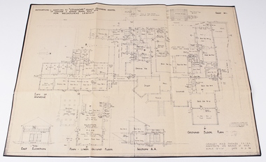 Melbourne Legacy
Work on paper - Document, plans, Alterations and additions to Stanhope Legacy Childrens' Hostel, Parts .2) and .3) 19.2.46. Parts .4) and .5) August 50
Detailed plans for the redevelopment of the Stanhope Childrens Hostel and Staff Accomodation.Melbourne Legacy established residences to aid children of deceased servicemen complete their education, take further education and find employmentEnvelope containing various Stanhope Residence plans and written history. 00042.1) beige coloured envelope with ’Stanhope Residence’ handwritten on front. 00042.2) Drawn plan ‘Alterations and Additions to Stanhope Legacy Childrens Hostel’ ‘Sheet No 1’ 00042.3) Drawn plan ‘Alterations and Additions to Stanhope Lecacy Childrens Hostel’ ‘Sheet No 2’ 00042.4) Drawn Plan ‘Staff Accomodation Stanhope’. 00042.5) ‘Plan of Drainage’ Stanhope. 00042.6) Short written account of Stanhope History 00042.7) Typed transcript of short written account of Stanhope history.residences, properties, stanhope -
Ringwood and District Historical Society
Plans, Education Department Victoria, Ringwood State School No 2997: Original Plans of proposed works from 1921 to 1992, 1931 to 1992
The Ringwood Primary School opened in Ringwood Street on 2nd November 1889 and eventually moved to Greenwood Avenue in 1921. These plans apply to the Greenwood Avenue location. The school closed in the 1990s.Forty two original plans of proposed works at Ringwood State School No. 2997. The dates vary from 1921, the first building, to 1992. Most of the plans are building plans for extensions or upgrades. -
Kew Historical Society Inc
Plan - Camberwell Panorama Estate, 1923
Subdivision plans and real estate flyers/brochures reveal a number of aspects of urban development and history. The Kew Historical Society's collection of these plans, as well as advertisements extracted from magazines, cover key aspects of community development and architectural history of Kew and Kew Eat as well as surrounding suburbs. While most of the plans in the collection were gifted to the Society by the former City of Kew, a number of other plans and advertisements have been donated by individuals, of which this is an example.Promotional brochure for the Camberwell Panorama Estate. The four page bifold handout advertises 216 home sites bounded by Bulleen Road, The Nook, Fortuna Avenue, and Doncaster Road. Other streets in the subdivision include: Sunburst Avenue, The Moor, and Macedon Avenue. The brochure has been damaged at some time in the past and so masking tape obscures the tram on page 1. Page 2 includes the plan of the subdivision, page 3 information about the site and a locality plan, while page 4 includes photographs and terms of sale. subdivision plans -- balwyn north (vic.), camberwell panorama estate -
Bendigo Historical Society Inc.
Document - ROYAL PRINCESS THEATRE COLLECTION: PLAN OF ALTERATIONS TO PRINCESS THEATRE, No date on Plan
Plan: Alterations to the Princess Theatre. Architects drawing by Cowper, Murphy and Appleford, Architects, 440 Little Collins St melbourneCowper, Murphy and Appleford, Architects, 440 Little Collins St melbournebuildings, commercial, princess theatre, princess theatre, alterations, cowper murphy and appleford -
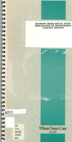 Greensborough Historical Society
Booklet, Wilson Sayer Core Pty Ltd, Diamond Creek retail study: preparation of development concept options, August 1989
Planning options for an extended retail development in Diamond Creek 1989.12 p. text, 12p. plans, spiral bound non-fictiondiamond creek, shire of diamond valley, retail developments -
 Mission to Seafarers Victoria
Plan - Architectural Plan, copy, Walter Butler, c. 2013
The copy was part of the conservation plan written by Peter Doig Architecture. Doig Architecture joined Baldasso Cortese in 2019.Large copy in black and white on glossy strong paper of the original bButler plan for the first central mission, Siddeley Street, held at the State Library of Victoria.peter doig, redevelopment, built heritage, walter richmond butler (1864–1949), siddeley street institute -
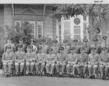 Bendigo Military Museum
Photograph - Royal Australian Survey Corps Planning Conferences, Army Survey Regiment, Bendigo, 1962, 1964, 1966, 1967, 1972, 1973
The Bi Annual Planning Conferences were to plan and coordinate the activities of the Royal Australian Survey Corps. The conferences were chaired by the Director of the Survey Corps and were attended by representatives from all elements of the Corps. The conferences were held at the Army Survey Regiment Fortuna Villa Bendigo . 1) Black and white photograph of the attendees at the Royal Australian Survey Corps Planning Conference November 1964 taken outside Fortuna Villa. Conference Chairman Brigadier Don Macdonald AM, MID Director of the Survey Corps. .2) Black and white photograph of the attendees at the Royal Australian Survey Corps Biennial Planning Conference November 1966 taken at Fortuna Villa. Conference Chairman Brigadier Don Macdonald AM, MID Director of the Survey Corps. .3) Black and white photograph of the attendees at the Royal Australian Survey Corps Biennial Planning Conference November 1966 taken in the Ball Room at Fortuna Villa. Conference Chairman Brigadier Don Macdonald AM, MID Director of the Survey Corps. Conference in progress. .4) Black and white photograph of the attendees at the Royal Australian Survey Corps Planning Conference November 1967 taken outside at Fortuna Villa. Conference Chairman Brigadier Frank Buckland OBE, MID; Director of the Survey Corps. .5) Black and white photograph of the attendees at the Royal Australian Survey Corps Biennial Planning Conference 1962 taken in the gardens of Fortuna Villa. Conference Chairman COL Don Macdonald AM, MID Director of the Survey Corps. Back Row L to R: LT M. Gler, LT F. Thorogood, LT. W.A Gillard, CAPT W.P. Constantine, MAJ E.U. Anderson, MAJ. J.K. Nolan, MAJ N.R.J. Hillier, CAPT W. Greer, MAJ. M.A. Marks, LT. G. Roy. Front Row L to R: 2T F. High, MAJ C.T. Carter, MAJ T. C. Sargent, MAJ J. L. Stedman, MAJ F.D. Buckland, LTCOL C.S. Tyler, COL D. Macdonald, LTCOL W.B. Relf, MAJ H.M. Hall, MAJ L.B. Sprenger, MAJ G.H. Tomlinson, MAJ S.W. Snow. .6) Black and white photograph of the attendees at the Royal Australian Survey Corps Biennial Planning Conference c1972 taken in the gardens of Fortuna Villa. Conference Chairman COL John K. Nolan, Director of the Survey Corps. .7) Black and white photograph of the attendees at the Royal Australian Survey Corps Biennial Planning Conference 05th October 1973 taken in the gardens of Fortuna Villa. Conference Chairman COL John K. Nolan, Director of the Survey Corps. Back Row L to R: MAJ Laker, SQNLDR Porter, CAPT Clues, SQNLDR McCormack, MAJ Eddy, FLTLT O’Loghlin, MAJ Illingworth, MAK Laing, MAJ Thorogood, MAJ Millar, CAPT Mason. Front Row L to R: MAJ Taylor, MAJ Ricketts, LTCOL Anderson, WGCOMD Whitely, LTCOL Ridge, MAJ Dalton, MAJ Todd..1 Nov 64 written on back, .2 RA Svy - Biennial Conference Nov 66 annotated on front, .3 Biennial Conference Nov 66 annotated on back, .4 RA Svy Planning Conference - Nov 67 annotated on front, .5 All officers annotated at footnotes on front, 6. No annotations, 7. All officers annotated on back and dated 5 Oct 73royal australian survey corps, rasvy, fortuna, army survey regiment, army svy regt, asr -
 Orbost & District Historical Society
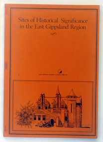
Booklet - book, Booklet, softcover, Sites of Historical Significance in the East Gippsland Region, October 1980
This is the second report by the East Gippsland Regional Planning Committees part of the Regional Studied Program in East Gippsland requested by Mrs Marion Le Cheminant.This is a useful reference tool. It documents sites of significance, including the Orbost area of East Gippsland.A stapled book with a brown/orange cover. On the front cover is a black print hand-drawn illustration of some buildings (possibly Bairnsdale Courthouse. The title, "Sites of Historical Significance in the East Gippsland Region", is in black print at the top. This is inside a black border.Sites of Historical Significance / in the East Gippsland Region / EAST GISPPSLAND REGIONAL PLANNING COMMITTEEhistoric sites, history, east gippsland, heritage -
 University of Melbourne, Burnley Campus Archives
Plan, Pat de Moulpied, Rose Garden, 1988
Most of these plans were held in Geoff Olive's office. (1) Preliminary concept South-East corner Burnley Gardens Re-design Proposals, Amenity Horticulture III, drawn by Pat de Moulpied 1988. Original turf path destroyed after Garden Week to be replaced with paving donated by Boral. (2) Rose Garden Site Analysis by Peter Jans, Parks & Gardens 1989, pencil on paper. On reverse, "B. Site Analysis & Design Changes. (3) 2 copies pencil on tracing paper, Planting plan. (4) Planting plan on tracing paper. (5) Planting plan (roughly final version?), 1 tracing paper, 6 photocopies. (6) Notes from Geoff Olive addressed to James Hitchmough. Also photocopies of 1 - 5 and some rough sketches. pat de moulpied, peter jans, gardens, geoff olive, andrew smith -
Port Melbourne Historical & Preservation Society
Plan - Seamen's Mission, Harry Norris, Blueprints, 1980s
Plans copied by Brian Couldrey when he was running the Mission Arts Centre in the building (1987 -1991).Photocopies (12) of blueprints of Plans for 1937 Seamen's Mission, by Harry Norris, in A4 sections - Ground floor - sheets f - l and First floor sheets a - e.architecture, missions to seamen, harry a norris -
Clunes Museum
Book, LANDCARE MANAGEMENT, 1998
ULLINA LAND CARE GROUP LANDCARE MANAGEMENT PLAN. FUNDED BY NATIONALLAND CARE PLAN. AUGUST 1998. PRINCIPAL CONSULTANT THOMSON HAY & ASSOCIATES PTY LTD.SPRING METAL BOUND BOOK - ULLINA LANDCARE GROUP LAND AND MANAGEMENT PLAN.local history, book, reference, landcare -
Clunes Museum
Document - BUSINESS PLAN, 2007
PREPARED FOR THE CREATIVE CLUNES WORKING PARTY UNDER THE AUSPICES OF THE CLUNES TOURIST AND DEVELOPMENT ASSOCIATION INC WITH FUNDING FROM THE DEPT OF PLANNING & COMMUNITY DEVELOPMENT BY VISION BUSINESS CONSULTING, NOVEMBER 2007BUSINESS PLAN FOR CREATIVE CLUNESlocal history, documents, plans, -
Whitehorse Historical Society Inc.
Article, Plans costed, 1992
Estimated cost of developing historic Matheson's Orchard is $276,000.Estimated cost of developing historic Matheson's Orchard is $276,000. Consultants recommend a five year restoration plan. The Forward Planning Committee voted to form an advisory Committee to help Council program the works, conservation and promotion of the property.Estimated cost of developing historic Matheson's Orchard is $276,000.orchards, matheson, charles, city of nunawading, matheson orchard -
 Kew Historical Society Inc
Plan - Subdivision Plan, Balwyn Theatre and Shop Sites, circa 1927-28, c.1927-28
The Kew Historical Society's map collection includes a substantial number of real estate subdivision plans, mainly of Kew but also of surrounding suburbs in Melbourne. Most of the subdivision plans date from the 1920s and 1930s when the districts old homes and local farmland were being split up to accommodate residential growth in the postwar period. These early plans were assembled by a local firm, Jas R Mather & McMillan, which had an office in Cotham Road. Many of the plans, and sometimes photos, were annotated by the agents. The ‘new’ Balwyn Picture Theatre was built and owned by Balwyn Theatres Pty Ltd in ca. 1928. By 1930, this first Balwyn Theatre was destroyed by fire after a break-in. Following the fire, a new cinema was constructed. This plan for a Cinema and eleven shops presumably dates from 1927/28 when the Company announced that this location in Whitehorse Road ‘was the most central and best suited [area] for their Theatre and shops’.Subdivision plans are historically important documents used as evidence for the growth of suburbs in Australia. They frequently provide information about when the land was sold as well as evidence relating to surveyors and real estate and financial agents. The numerous subdivision plans in the Kew Historical Society's collection represent working documents, ranging from the initial sketches made in planning a subdivision to printed plans on which auctioneers or agents listed the prices for which individual lots were sold. In a number of cases, the reverse of a subdivision plan in the collection includes a photograph of a house that was also for sale by the agent. These photographs provide significant heritage information relating house design and decoration, fencing and household gardens.The photograph may also be aesthetically significant depending on the importance of the photographic atelier.Subdivision plan showing the Balwyn Theatre and its adjoining shop sites in Whitehorse Road Balwyn. The 11 shop sites were noted for their depth (133 ft - 145 ft. [Map.0041]balwyn theatre -- balwyn (vic.), subdivisions -- balwyn (vic), subdivision plans -
 Kew Historical Society Inc
Plan - Subdivision Plan, J R Mathers & McMillan, Normanby Estate, c.1913
The Kew Historical Society's map collection includes a substantial number of real estate subdivision plans, mainly of Kew but also of surrounding suburbs in Melbourne. Most of the subdivision plans date from the 1920s and 1930s when the districts old homes and local farmland were being split up to accommodate residential growth in the postwar period. These early plans were assembled by a local firm, Jas R Mather & McMillan, which had an office in Cotham Road. Many of the plans, and sometimes photos, were annotated by the agents.Subdivision plans are historically important documents used as evidence for the growth of suburbs in Australia. They frequently provide information about when the land was sold as well as evidence relating to surveyors and real estate and financial agents. The numerous subdivision plans in the Kew Historical Society's collection represent working documents, ranging from the initial sketches made in planning a subdivision to printed plans on which auctioneers or agents listed the prices for which individual lots were sold. In a number of cases, the reverse of a subdivision plan in the collection includes a photograph of a house that was also for sale by the agent. These photographs provide significant heritage information relating house design and decoration, fencing and household gardens.The photograph may also be aesthetically significant depending on the importance of the photographic atelier.The Normanby Estate, which was adjacent to Normanby Road, Kew East, included thirty-one lots for sale. Streets on the subdivision plan include Adeney Avenue, Park Hill Road, Normanby Road, Weir Street and Wharton Street. Cotham Road and its tramway are shown nearby. The plan is interesting as it shows Wharton Street, named after the architect and town planner George Wharton, who was the first chairman of the Municipality of Kew. The street was to later be renamed Cecil Street. Also shown are proposed ‘Municipal Gardens’ where Parkhill Drive is now located."D" in top left corner. Stamped auctioneers contact details: "Jas. R. Mathers & Son & McMillan / Auctioneer & Land Salesmen, / 271 Collins Street / Melbourne" and Jas. R. Mathers / Estate & Financial Agent / Cotham Road / Kew".weir street - kew, wharton street - kew, normanby road - kew, cotham road - kew, municipal gardens - kew, park hill parkhill road - kew, braemar - kew, subdivision plans - kew -
Federation University Historical Collection
Map - Plan, Ballarat Deep Leads and Mines, 1992, 1992
This is Bulletin No. 62: Deep Lead Gold Deposits in Victoria. Map No.6 Ballarat Sheet 1 of 2 The map shows geology, topography and information on mines in the following areas: one large map of the Ballarat area with five enlargements for: Sago Hill District; Scarsdale District; Pitfield Plains District; Berringa Gold Field and Rokewood District. Ballarat Mines and Deep Leads Report No.94 (Finlay and Douglas,1992) provides a summary of the Geological Survey of Victoria mines database, references and geology for most of the mines on this map. Geology Compilation: simplified from earlier Departmental mapping with minor field checking by E.N.M. Plier-Malone. Very large rectangular sheet of paper with seven coloured maps of various sizes and a small green rectangle on the bottom rhs with a map of Victoria superimposed over a poppet head. this rectangle includes information of the other maps shown. The background for these maps is white. Also includes tables of names of mine companies, name of shafts and gold production.gold mines of australia, gold mines of victoria, gold mines- ballarat and district, gold mines pitfield plains district, gold mines scarsdale district, gold mines berringa gold field, gold mines rokewood district, gold mines sago hill district, map - gold mines, map - gold mines in victoria, ballarat, pitfield, scarsdale, berringa, rokewood, sago hill, deep lead gold deposits in victoria, geological survey - gold deposits in victoria, mining, gold deposits in victoria, gold mines in victoria, rokewook, pitfield plains -
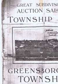 Greensborough Historical Society
Plan, Greensborough Township Estate, 01/09/1923
Sub-division into 129 lots of land belonging to the Scotland Family, bounded by William Street, Eliza Street, James (Jessop) Street and south of Lorimer Street. Auction 1 September 1923Photocopy, double-sidedsubdivision plans, greensborough township estate, scotland family -
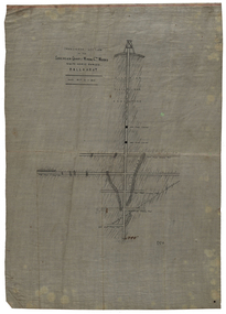
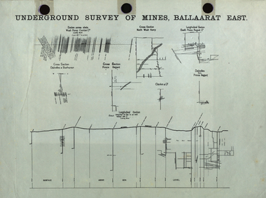 Federation University Historical Collection
Plan, Undergrand Survey of Mines Ballarat East
mining, plans, surveying, ballarat east, cgt -
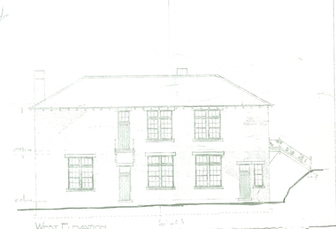 Federation University Historical Collection
Plan, West Elevation of the Ballarat School of Mines Building Old Plumbing Building
This building was built in 1918-19 to a design by H.J. Kerr, District Architect (Western District), under the design control of the Chief Architect, S.C. Brittingham, Public Works Department. Their initials appear on the attached copy of the original drawing of the building. (Research by David Rowe)Copy of the Plumbing building on the grounds of the Ballarat School of Mines campusballarat school of mines, plans, building o, plumbing, old plumbing building, h.j. kerr, s.c. brittingham -
 Federation University Historical Collection
Plan, Parish of Dowling Forest, County of Ripon and Grenville, 19
Scale [1:31 680]. 40 chains to 1 in.Geological map on a cadastral base, showing the occurence of reefs, and alluvial deposits. Relief shown by contours.dowling forest, wyndholm, wyndholm pre-emptive right, miners rest, ballarat racecourse, winter's swamp, police reserve, miner's rest, winters swamp, geology -
 Federation University Historical Collection
Plan, Sovereign Quartz Mining Co
Transverse section of the Sovereign Quartz Mining Company's works hand drawn onto paper on waxed linen. The scale is 80- feet to 1 inch or 1:960mining, sovereign quartz mining co., cgt -
 Federation University Historical Collection
Plan, Prince Regent Co. Transverse Section
Transverse section of the Prince Regent Company.prince regent co, foster allan, ernest lidgy, cgt -
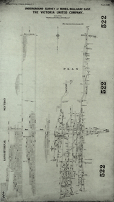 Federation University Historical Collection
Plan, Underground Survey of Mines, Ballarat East. The Victoria United Company, 1903
Underground Survey of The Victoria United Company from Geological Survey of Victoria, Memoirs No. 4.ballarat east, victoria united company, cgt, mining, geological survey, longitudinal section -
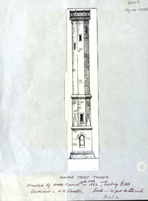 Federation University Historical Collection
Plan, Ballarat School of Mines Gauge Tower, 1882, 1882
The Gauge Tower was designed by architect Henry Richards CaselliReproduction of an architectural drawing of the Ballarat School of Mines Gauge Tower as reproduced in a Ballarat School of Mines Annual report.henry caselli, henry richards caselli, ballarat school of mines, gauge tower -
Clunes Museum
Document - PLAN, TITLE PLANS OF GLENGOWER
1 PAGE PHOTOCOPY OF MAP OF GLENGOWER3153 G(3) 28 COMPILED AUGUST 1875 COMPARED WITH ORIGINALS 5/6/1965 AND 4/8/1976photo-lithographic, glengower titles plan -
Stawell Historical Society Inc
Archive - Plan, Stawell Water Supply, Stawell Water Supply Detail Drawing of Valve House, c 1878
Part of Infrastructure on Big Hill For Stawell Water Supply Large Technical drawing with some colouring. Torn on right hand sideScale 2 ft to 1 inch -
Stawell Historical Society Inc
Archive - Plan, Stawell Water Supply, Detail Drawings of Section of Culvert Pipes Stawell Water Supply, c 1878
Part of Infrastructure on Big Hill For Stawell Water Supply Large Section Technical drawingsScale 2 ft to 1 inch -
Stawell Historical Society Inc
Map - Plan, Glenorchy Cemetery, c 1960
Printed map of plots on backing cardScale 1 inch to 12 feetburials -
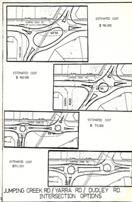 Wonga Park Community Cottage History Group
Work on paper (Item) - Plan, Wonga Park: Four Options for development of Jumping Creek, Yarra and Dudley Roads corner c. 1983
Prepared by the Shire of Lillydale during discussion with Wonga Park & District Residents' Association regarding the redevelopment of the intersection