Showing 7371 items matching "24"
-
 Eltham District Historical Society Inc
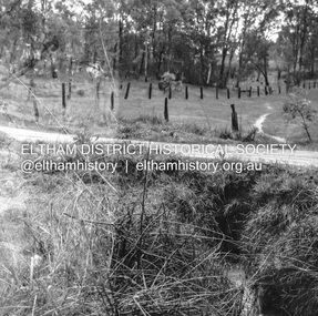
Negative - Photograph, J.A. McDonald, Fordhams Road, Eltham, 24 July 1962
Culvert discharging towards land owned by Holloway & Spicer about 3pm on 24 July 1962 Heavy rain 60 years later it still appears to present as a concern - see Google Street View (Nov 2021) https://goo.gl/maps/x61yWvAc5UjJ2d8y9Record of various Shire of Eltham infrastructure works undertaken during the period of 1952-1962 involving bridge and road reconstruction projects, sometimes with Eltham Shire Council Project Reference numbers quoted. It was during this period that a number of significant improvements were made to roads and new bridges constructed within the shire that remain in place as of present day (2022). In many situations, the photos provide a tangible visible record of infrastructure that existed throughout the early days of the Shire. The album was put together by or under the direction of the Shire Engineer, J.A. McDonald.1962-07-24, culvert, eltham, fordhams road, infrastructure, shire of eltham -
 Eltham District Historical Society Inc
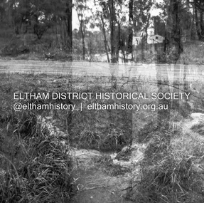
Negative - Photograph, J.A. McDonald, Fordhams Road, Eltham, 24 July 1962
Culvert discharging towards land owned by Holloway & Spicer about 3pm on 24 July 1962 Heavy rain 60 years later it still appears to present as a concern - see Google Street View (Nov 2021) https://goo.gl/maps/x61yWvAc5UjJ2d8y9Record of various Shire of Eltham infrastructure works undertaken during the period of 1952-1962 involving bridge and road reconstruction projects, sometimes with Eltham Shire Council Project Reference numbers quoted. It was during this period that a number of significant improvements were made to roads and new bridges constructed within the shire that remain in place as of present day (2022). In many situations, the photos provide a tangible visible record of infrastructure that existed throughout the early days of the Shire. The album was put together by or under the direction of the Shire Engineer, J.A. McDonald.1962-07-24, culvert, eltham, fordhams road, infrastructure, shire of eltham -
 Ballarat Tramway Museum
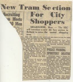
Newspaper, The Courier Ballarat, "New Tram Section For City Shoppers", 24/07/1951 12:00:00 AM
Yields information about a new ticket for shoppers and short journeys in Ballarat and the use of tickets in the city section.Newspaper cutting from Ballarat Courier (p2) of 24/7/1951 (Tues), titled "New Tram Section For City Shoppers" outlining introduction of a new tram fare to cover travel in City area of Ballarat. Notes the problem with transfer tickets. Record updated and images added 20/8/2013.Year in read pencil on reartrams, tramways, ballarat tramways, fares, sec -
 Greensborough Historical Society
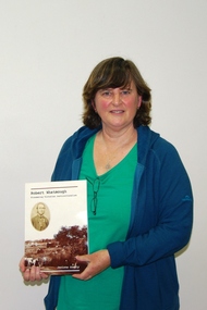
Photograph - Digital Image, Marilyn Smith, Jacinta Crealy and Book Launch June 2017, 24/06/2017
A group of photographs taken at the June 24 2017 meeting of Greensborough Historical Society. At this meeting, Jacinta Crealy spoke about and launched her book on Robert Whatmough (photo 1). At afternoon tea, a cake was cut to commemorate Robert Whatmough's life (1815-1887).Digital copy of colour photographsgreensborough historical society, jacinta crealy, robert whatmough -
 Bendigo Historical Society Inc.
Map - TANDARRA : COUNTY OF BENDIGO, 14-3-24
Map. Tandarra, County of Bendigo, Talambe, Yallook, Neilborough, Whirrakee, Kamarooka. Myers Creek, Tandarra Estate. Photo-Lithographed at the Department of Lands and Survey, Melbourne by W.J. Butson, 14-3-24. Price 1/-. By authority Albert J. Mullett, Government Printer, Melbourne. (number 25 in map cupboard 1)Albert J. Mullett, Government Printer, Melbourne.map, bendigo, tandarra -
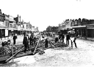 Ballarat Tramway Museum
Photograph - Geelong Tramway new tracks
Tram tracks being laid in Moorabool St, looking north. Curved track heads into Ryrie St, 1911. See also Item 9214.Black and white print on paper.GRS710/25/1/4 and 24-4 written on the reverse in pencil. No. 1 in a circle, 25-4 and an ink 5 overwriting the pencil 4 in 24, written on the reverse in ink.geelong tramways new tracks -
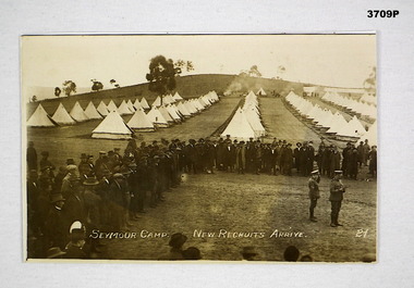 Bendigo Military Museum
Photograph, c.1915 - 1916
Items in items re James Edgar KOCH No 2096 AIF. Refer Reg No 1256 for his service history.Copy of original sepia photo showing a camp with tents in the background & new recruits in civilian clothes in the foreground.Printed in white at bottom: SEYMOUR CAMP NEW RECRUITS ARRIVE 24photograph, seymour camp -
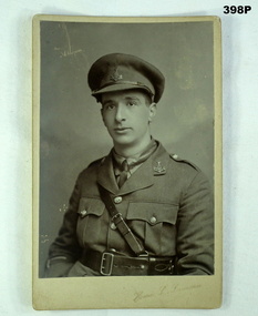 Bendigo Military Museum
Photograph - PHOTOGRAPH BRITISH SOLDIER, 1914-17
William Edwin Cook, refer 875, 399.2, 401, 419, 655.3.Photo Sepia Color Soldier (British) in uniform, Officer. Photo is on cardboard with gold edging writing on the back in black penWilliam Edwin Cook 21/2/1894 - 24/4/1918photography military, british officer ww1 -
Glenelg Shire Council Cultural Collection
Photograph - Photograph - Sir Henry Winneke and Lady Winneke, 24 July 1975, 1975
Port of Portland Authority archivesFront: (no inscriptions) Back: July 24, '75 (pencil, centre left)port of portland archives, sir henry winneke, lady winneke -
Glenelg Shire Council Cultural Collection
Photograph - Photograph - Sir Henry Winneke and Lady Winneke, 24 July 1975, 1975
Port of Portland Authority archivesFront: (no inscriptions) Back: July 24, '75 (pencil, lower centre)port of portland archives, sir henry winneke, lady winneke -
Glenelg Shire Council Cultural Collection
Photograph - Photograph - Sir Henry Winneke and Lady Winneke, 24 July 1975, 1975
Port of Portland Authority archivesFront: (no inscriptions) Back: July 24 1975 (pencil, lower centre)port of portland archives -
Glenelg Shire Council Cultural Collection
Photograph - Photograph - Sir Henry Winneke and Lady Winneke, 24 July 1975, 1975
Port of Portland Authority archivesFront: (no inscriptions) Back: July 24, 1975 (pencil, centre left)port of portland archives, sir henry winneke, lady winneke -
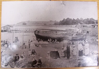 Glenelg Shire Council Cultural Collection
Photograph - Photograph - beach scene, Portland, n.d
Displayed at History House.Black and white photograph of Portland Bay mounted on thick cardboard. Eyelet in top of mount. Families on beach. Lighters (wrecked) on beach. Copper in foreground. Children on swing. Pier in background.Back: Donated to History House 24/1/1992 by Vern McCallum.portland, beach scene, photography -
 Federation University Historical Collection
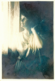
Photograph - Black and White, Frank Wright, Laura Wright, 1924, 2/1/1924
Laura Wright was the sister of Frank Wright who was a renown resident of Smeaton, where they was born. They lived at Laura Villa, and attended Smeaton State School with their siblings. Their father William was a gold miner and their mother's name was Sarah. Their family won many singing and instrumental awards. Frank was tutored by Percy Code and was awarded a gold medal for the highest marks in the ALCM examinations in the British Colonies at the age of seventeen years. He became the Australian Open Cornet Champion by the age of eighteen. A year later, Frank conducted the City of Ballarat Band, and later the Ballarat Soldiers’ Memorial Band. He formed the Frank Wright Frisco Band and Frank Wright and his Coliseum Orchestra. These bands won many South Street awards, and Frank as conductor won many awards in the Australian Band Championship contest. In 1933 Frank Wright sailed to England to conduct the famous St Hilda’s Band and was later appointed Musical Director of the London County Council, where he organized many amazing concerts in parks, in and around the London district. He was made Professor of Brass and Military Band Scoring and conducted at the Guildhall of Music and Drama. Frank was often invited to adjudicate Brass Band Championships around Europe, in Australia, including South Street and in New Zealand. The Frank Wright Medal at the Royal South Street competition is awarded to an individual recognized as making an outstanding contribution to brass music in Australia. Laura married Mr W.M. Ritchie and lived in BallaratBlack and white photograph of a woman standing beside a net curtained window. The sunlight illuminates the face and torso. There is a marked contrast between the light and the darkened room. The woman is Laura WrightWritten in pen on the back - Laura Wright, 2/1/24, F.W.laura wright, frank wright, cornet, conductor -
 City of Moorabbin Historical Society (Operating the Box Cottage Museum)
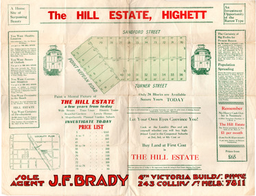
Flyer - Hill Estate, Highett
Land sales in the Municipality of Moorabbin increased when the train line from the City to Frankston was electrified.Example of the progress of the Municipality of MoorabbinAdvertising flyer for auction of real estate sales - plan of building blocks for saleThe Hill Estate, Highett - 24 Housing Blocks - J. F. Bradypoint nepean road (nepean highway), turner street, sanford street, real estate, highett -
Port Melbourne Historical & Preservation Society
Photograph - Sketch or engraving, workers, Swallow & Ariell, Australasian Sketcher, 11 Feb 1882
Sketch/Engraving of workers at Swallow & Ariell Factory, showing the oven and packing by Australasian Sketcher. 11-02-1882.On rear: 24, S&A & Australasian Sketcher 11 Feb 1882. P44industry - manufacturing, industry - food, swallow & ariell ltd -
Port Melbourne Historical & Preservation Society
Photograph - Sketch or engraving, workers, Swallow & Ariell, Australasian Sketcher, 11 Feb 1882
Sketch/Engraving of workers at Swallow & Ariell Factory, showing kneading the dough and taking the biscuits out of the machine. Australasian Sketcher 11-02-1882On rear: 24. S&A Australasian Sketcher 11 Feb 1882. P44industry - manufacturing, industry - food, swallow & ariell ltd -
Clunes Museum
Functional object - WASHING BOARD
Wooden frame with lined glass scrubbing areaOn top of frame printed in ink; "POSSUM" Trademark Sticker on back "24"domestic item, possum brand, washboard -
University of Melbourne, Burnley Campus Archives
Slide - Glass slide, 1891-1905
7 diagrams.24. Fig. 22.-Claviceps purpurea. I ergot on rye-grass.fungal diseases, diagram -
 Uniting Church Archives - Synod of Victoria
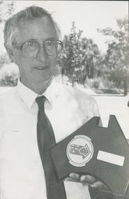
Photograph, Rev Alan Body, 1988
Rev Alan Body ministered at Wentworth (the Victorian parish in New South Wales) for 10 years, and was subsequently transferred to Boort. During his time at Wentworth he conducted a patrol ministry, travelling between 8000 and 10,000 kilometres per year visiting the area from Wentworth to Pooncarie, to Coombah on the Broken Hill road, out west to the South Australian border, south to the Murray and upstream to Wentworth.B & W waist length photograph of Rev. Alan Body with his Wentworth Shire Australia Day Citizen Award."Alan Body page 31 C&N 24/2/1988"rev alan body -
 Uniting Church Archives - Synod of Victoria
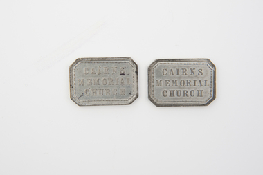
Communion token
B084.1 & B084.2 - Rectangular communion tokens with text on the obverse and text and scripture reference on the reverse.Obverse: "CAIRNS MEMORIAL CHURCH" Reverse: "1 CORINTHIANS 24-25"john knox free church melbourne -
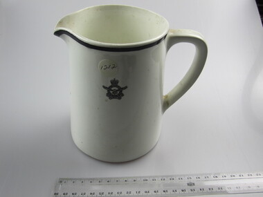 Ballarat RSL Sub-Branch Inc.
Jug - RAAFA Insignia Porcelain Medium
Inscription = 24 No. 10 North Staffordshire Pottery, Hanley, Made in Englandcollectables, ballarat rsl, ballarat -
 Kew Historical Society Inc
Book, Libraries Board of South Australia, Narrative of a Survey of the Coasts of the Intertropical and Western Coasts of Australia performed between the Years 1818 and 1822 in two volumes (Vol.1), 1969
This two-volume work by Captain Phillip Parker King (1791–1856) was published in 1827, and describes the Royal Navy's 1817–22 surveying expedition to chart the coastal regions of Australia. King carried out the surveys in two successive ships, the Mermaid, which was declared unseaworthy in 1820, and the newly commissioned Bathurst. He worked on the charts, which were published by the Hydrographic Office, for two years after his return to England. He was made a Fellow of the Royal Society, and later undertook a similar surveying voyage, in which he was accompanied by Captain Fitzroy on the Beagle, around the coast of South America. The book is derived from the author's journal, and describes not only the voyages but also the towns and settlements of the region. Volume 2 continues the survey along the north and west coasts of Australia, and contains an appendix describing winds, currents, ports and islands.Facsimile Editions No.30. 2 v. : illus., fold. charts, tables. non-fictionThis two-volume work by Captain Phillip Parker King (1791–1856) was published in 1827, and describes the Royal Navy's 1817–22 surveying expedition to chart the coastal regions of Australia. King carried out the surveys in two successive ships, the Mermaid, which was declared unseaworthy in 1820, and the newly commissioned Bathurst. He worked on the charts, which were published by the Hydrographic Office, for two years after his return to England. He was made a Fellow of the Royal Society, and later undertook a similar surveying voyage, in which he was accompanied by Captain Fitzroy on the Beagle, around the coast of South America. The book is derived from the author's journal, and describes not only the voyages but also the towns and settlements of the region. Volume 2 continues the survey along the north and west coasts of Australia, and contains an appendix describing winds, currents, ports and islands.australia -- description and travel -- to 1850., hydrography -- australia., natural history -- australia. -
 Kew Historical Society Inc
Book, Libraries Board of South Australia, Narrative of a Survey of the Coasts of the Intertropical and Western Coasts of Australia performed between the Years 1818 and 1822 in two volumes (Vol.2), 1969
This two-volume work by Captain Phillip Parker King (1791–1856) was published in 1827, and describes the Royal Navy's 1817–22 surveying expedition to chart the coastal regions of Australia. King carried out the surveys in two successive ships, the Mermaid, which was declared unseaworthy in 1820, and the newly commissioned Bathurst. He worked on the charts, which were published by the Hydrographic Office, for two years after his return to England. He was made a Fellow of the Royal Society, and later undertook a similar surveying voyage, in which he was accompanied by Captain Fitzroy on the Beagle, around the coast of South America. The book is derived from the author's journal, and describes not only the voyages but also the towns and settlements of the region. Volume 2 continues the survey along the north and west coasts of Australia, and contains an appendix describing winds, currents, ports and islands.Australian Facsimile Editions No.30. 2 v. : illus., fold. charts, tables. non-fictionThis two-volume work by Captain Phillip Parker King (1791–1856) was published in 1827, and describes the Royal Navy's 1817–22 surveying expedition to chart the coastal regions of Australia. King carried out the surveys in two successive ships, the Mermaid, which was declared unseaworthy in 1820, and the newly commissioned Bathurst. He worked on the charts, which were published by the Hydrographic Office, for two years after his return to England. He was made a Fellow of the Royal Society, and later undertook a similar surveying voyage, in which he was accompanied by Captain Fitzroy on the Beagle, around the coast of South America. The book is derived from the author's journal, and describes not only the voyages but also the towns and settlements of the region. Volume 2 continues the survey along the north and west coasts of Australia, and contains an appendix describing winds, currents, ports and islands.philip parker king, natural history -- australia., australia -- description and travel -- to 1850. -
Vision Australia
Text, Newspaper clippings 21 (1985-1986), 1985-1986
News stories including fundraising events and from the blind and low vision community.1 folder with newspaper cuttingsVarious articles from 24/8/1985 - 22/2/1986association for the blind -
 Kilmore Historical Society
THE VICTORIAN MAGISTRATE, 1924
A survey and classification of the Statute Law, case law, procedure and practice applicable to Police Magistrates, Coroners, Justices of the Peace and special magistrates, and to Courts of Petty Sessions, Courts of general sessions, Coroner's Courts and Children's Courts.Grey-green cloth-bound hardcover book, faded spine and front cover, wear at corners. Minor insect damage inside front & back cover & flyleaves. Foxing back & front flyleaves. Structurally sound condition. 723 pp.Pencil inscription inside front cover, 'Received 16/10/24'.victorian, magistrate, kilmore court house library -
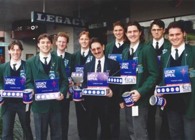 Melbourne Legacy
Photograph, Legacy Appeal 1996, 1996
Photos during Badge Week in September 1996, including President Ray Ward selling badges with school boys. The article in the December 1996 edition of the Answer says they were expecting to reach $300,000 from the Annual Appeal. A record of the fundraising for the Legacy Appeal in 1996.Colour photo x 5 of various badge sellers, including President Ray Ward, during Badge week and an article in The Answer.Printed on the back legacy appeal, fundraising, badge week, answer, ray ward -
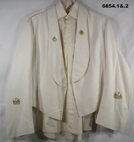 Bendigo Military Museum
Uniform - MESS DRESS, Norm M. Aitchison
Items issued to Bertram Charles Addington. Refer to Cat No 6853.3 for B.C Addingtons service details.1) Vest, white long sleeves, WO1 metal badges of rank on arms. On collars are metal badges - Oak wreath laurels, Crown on top, crossed swords in centre. Letter “R” on epaulettes. .2) Shirt, cream/white. Long sleeved, 6 buttons on front. .3) Black bow tie, with a neck band attached. .4) Cummerbund, red silk.Written on cummerbund is = “24/01 Addington B. 1/9/72”army, formal uniform, passchendaele barracks trust -
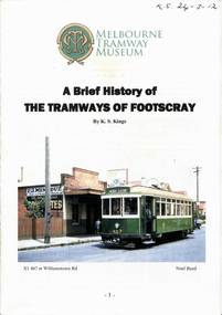 Melbourne Tram Museum
Book, Melbourne Tramway Museum, "A brief history of the Tramways of Footscray", Mar. 2012
Book - 16 A4 pages, centre stapled, to A5, titled "A brief history of the Tramways of Footscray", by Keith Kings, based on an original article published in Electric Traction June 1962. Published by the "Melbourne Tramway Museum" TMSV, 2012. Covers the formation of the FTT, includes a map by Liam Davies, economics, trams used, the WW1, Post Way years, traffic, photos, the declining years, closure, references."KS 24-3-62" on top right hand corner in ink.trams, tramways, ftt, footscray, x1 class, x2 class, world war 2, closure -
 Melbourne Legacy
Photograph - Photo, Anzac Day, 1924
Photos of wreaths at the old war memorial after an Anzac Day service. A war memorial/Cenotaph to the 1914-1918 war was originally erected in Spring Street outside the Victorian Parliament. It was a flimsy half-sized replica of the London Symbol of Remembrance in Whitehall built of timber and fibro cement and was only meant to be temporary. Anzac Day services were held at this memorial in the 1920s and early 1930s. These photos were taken before the Shrine of Remembrance was erected and dedicated in 1934 as the National War Memorial of Victoria. It is possible that the stamp on the reverse, '4 24', means April 1924, also see a similar photo at 01371. Items were in an envelope with other photos and programmes from different School Student ceremonies. Labelled S15 in red pen it was part of an old archive numbering system (S=Shrine), that showed there has been efforts in the past to collect, order and save items of Legacy's history. From articles in Trove: The temporary cenotaph was the original first world war memorial until the Shrine of Remembrance was dedicated in 1937. The cenotaph was a half size replica of the London Symbol of Remembrance in Whitehall. It was made from timber and plaster and was initially meant to only last for the 1926 Anzac day service and be removed. With annual upkeep it remained until at least 1934 when ex-service men proceeded from the incomplete Shrine to the cenotaph on the steps of Parliament House on Anzac day.A record of an Anzac Day ceremony at the old temporary war memorial in Spring Street.Black and white photo x 3 of wreaths laid on ANZAC Day at the old First World War memorial in Spring Street.Stamped with a round stamp 'Printed by Harringtons" in grey ink, stamped '4 24' in blue ink. Handwritten 'ANZAC DAY' in blue pen on one photo.anzac day, wreath laying ceremony