Showing 1527 items
matching aerial photograph
-
 Stawell Historical Society Inc
Photograph, Aerial Photos of Stawell from a Hot Air Balloon 1985 -- 12 Photos
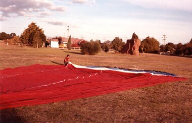
Series of 12 Aerial Photos of Stawell. Hot Air Balloon 1985. Photos taken during hot air balloon rides May & June 1935. The rides left from land near leisure complex, Houston St and Newington Rd corner. The rides first over Stawell and drifted towards the Black Range. This vacant site is now the location of Stawell indoor heated and outdoor pools. 1 & 2. Setting up balloon. 3. North Park Area Lamont St. 4. Netball & Tennis courts Athletic track. 5 Wimmera St, Trotting track & Drive-in Scallan St. & Main St. 6. State School 502 Jenning-Campbell & Houston St's. 7 Ligar St. crosses Campbell & Houston St's. 8. Ord St, 502 School yard. 9. Central Park Napier, Wakeham & Shirreff St's also Railway & Foot Bridge. 10. Central Park. 11. Sloane St. on left Trotting track & Drive-in. 12. The Old Lake oval. Series of twelve photos mostly consisting of aerial photos and two of a large balloon on the ground. stawell -
 Ringwood and District Historical Society
Photograph, Aerial view of Park Orchards and Ringwood - c.1960
Catalogue card reads, "Aerial view of Ringwood". -
 Bendigo Military Museum
Photograph - 4th Field Survey Squadron – Operation MIZMAZE 92, Kimberley region, Western Australia, 1992
This is a set of 40 photographs taken in 1992 during 4th Field Survey Squadron’s deployment on Operation MIZMAZE 92 in the Kimberley region of Western Australia from the 13th of May to the 14th of July 1992. The area of operations was Wyndham, Halls Creek and Sandfire Flat. It was a two-part operation involving the field completion of topographic maps and the acquisition of mapping control by GPS field parties utilising Texas Instruments TI4100 Global Positioning System receivers. Survey parties conducted field checking of topographic maps and GPS control acquisition in Perentie 110 Series Survey variant FFR Land Rovers. Three Bell Kiowa LOH helicopters provided by 162 Recce Sqn supported field checking and limited deployment of GPS surveys parties. C-l30 Hercules from 36 Sqn supported deployment and extraction of personnel and equipment to and from from the AO. A Cessna 404 Titan Ambassador from Vee-H Aviation was used as the Wild RC10 camera platform for aerial photography acquisition.This is a set of 40 photographs taken in 1992 during 4th Field Survey Squadron’s deployment on Operation MIZMAZE 92 in the Kimberley region of Western Australia. The colour photographs are on 35mm negative film and are part of the Army Survey Regiment’s Collection. The photographs were scanned at 96 dpi. .1) - Photo, colour, 1992. CAPT Craig Hersant. .2) - Photo, colour, 1992. Unidentified officer/soldier. .3) & .4) - Photo, colour, 1992. Aboriginal rock art - Wandjina Gunduran, Donkey Creek. .5) - Photo, colour, 1992. Aboriginal rock art - Track Wandjinas, Donkey Creek. .6) & .7) - Photo, colour, 1992. CAPT Craig Hersant. .8) - Photo, colour, 1992. Kimberley region topography. CPL Glen Weatherell. .9) - Photo, colour, 1992. Unidentified personnel .10) - Photo, colour, 1992. Supermarket at unknown location. .11) to .13) - Photo, colour, 1992. Caravan park at unknown location. .14) - Photo, colour, 1992. Old bridge at Fitzroy Crosssing. .15) & .16) - Photo, colour, 1992. Survey party in Perentie 110 Series Land Rover. .17) & .18) - Photo, colour, 1992. Kimberley region topography. .19) - Photo, colour, 1992. Kimberley region topography. CPL Glen Weatherell. .20) - Photo, colour, 1992. Kimberley region topography, possibly the Bungle Bungles. .21) - Photo, colour, 1992. Kimberley region topography. SGT Frank Downie. .22) - Photo, colour, 1992. Kimberley region topography: the Bungle Bungles. .23) - Photo, colour, 1992. Kimberley region topography: the Bungle Bungles. .24) - Photo, colour, 1992. Kimberley region topography: the Bungle Bungles. SPR Neil Pedler. .25) & .26) - Photo, colour, 1992. Kimberley region topography: the Bungle Bungles. .27) - Photo, colour, 1992. Kimberley region topography. .28) - Photo, colour, 1992. Survey party with Perentie 110 Series Land Rover. .29) - Photo, colour, 1992. Kimberley region topography. .30) - Photo, colour, 1992. Survey party outside Perentie 110 Series Land Rover. .31) & .32) - Photo, colour, 1992. Survey party operating TI4100 GPS Receiver next to Perentie 110 Series Land Rover. SGT Eddie Jacobs. .33) & .34) - Photo, colour, 1992. Survey party operating TI4100 GPS Receiver next to Perentie 110 Series Land Rover. Unidentified surveyor. .35) - Photo, colour, 1992. Kimberley region topography. Hand water pump at well. .36) - Photo, colour, 1992. Survey party in Perentie 110 Series Land Rover. .37) - Photo, colour, 1992. Kimberley region topography. CPL Glen Weatherell. .38) - Photo, colour, 1992. Kimberley region topography viewed from Bell Kiowa LOH helicopter. .39) & .40) - Photo, colour, 1992. Unidentified surveyor field checking a preliminary map in a Bell Kiowa LOH helicopter..1P to .40P – There are no personnel identified. ‘1992 OP MIZMAZE annotated on negative sleeve.royal australian survey corps, rasvy, 4 fd svy sqn, op mizmaze 92 -
 Bendigo Military Museum
Photograph - 4th Field Survey Squadron – Operation ARIGHT 91, Queensland, 1991
This is a set of 16 photographs taken during 4th Field Survey Squadron’s deployment on Operation ARIGHT 91 in Queensland from the 8th of July to the 5th of September 1991. The area of operations was the top end of the Cape York Peninsula, islands of the Torres Strait and the southern coast of PNG. Field parties utilised Texas Instruments TI4100 Global Positioning System receivers. Concurrent with GPS operations Doppler point positioning observations were carried out by field parties using Magnavox MX 1502 receivers on six of the control points. Two Bell UH-1H Iroquois helicopters from RAAF’s 171 COMD and Liaison Squadron were primarily used to deploy GPS field parties. Identification photography of control points was taken by air camera operators in AAAvn Pilatus Porter aircraft from 173 Gen Spt Sqn fitted with an RC10 aerial camera.This is a set of 16 photographs taken in 1991 during 4th Field Survey Squadron’s deployment on Operation ARIGHT in Queensland. The colour photographs are on 35mm negative film and are part of the Army Survey Regiment’s Collection. The photographs were scanned at 96 dpi. .1) to .3) - Photo, colour, 1991. Area of Operations (AO) coordination maps. .4) - Photo, colour, 1991. GPS acquisition post-processing. L to R: LT Simon Buckpitt, SSGT Steve Winner, WO2 Ken Talbot-Smith. .5) to .6) - Photo, colour, 1991. Base camp unidentified personnel. .7) - Photo, colour, 1991. L to R: OPS WO - WO2 Ken Talbot-Smith, DET SSM WO1 Stevo Hinic. .8) - Photo, colour, 1991. Base camp unidentified personnel. .9) - Photo, colour, 1991. Base camp L to R: unidentified (x2), OPS WO - WO2 Ken Talbot-Smith. .10) - Photo, colour, 1991. Base camp unidentified soldier. .11) - Photo, colour, 1991. Base camp L to R: CPL Andy Love, unidentified, SGT Steve McGuiness. .12) - Photo, colour, 1991. Base camp at Horn Island Army Compound. .13 to .16) - Photo, colour, 1991. Unknown locations in Area of Operations..1P to .16P – There are no personnel identified. ‘1991 OP ARIGHT’ annotated on negative sleeve.royal australian survey corps, rasvy, 4 fd svy sqn, op aright 91 -
 Old Colonists' Association of Ballarat Inc.
Photograph, Charles Anderson Grove, c1982
... Charles Anderson Grove Retirement village Aerial Colour ...Colour photograph of Charles Anderson Grovecharles anderson grove, retirement village, aerial -
 Lakes Entrance Historical Society
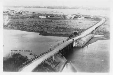
Photograph - Aerial view of North Arm Bridge, 1930c
... Bridges Township Black and white photograph concrete bridge ...Black and white photograph concrete bridge over North Arm, two people at southern end of bridge, swampy area approaching Club Hotel. Lakes Entrance Victoriabridges, township -
 Whitehorse Historical Society Inc.
Map, Husband Road, Forest Hill, 1972
... Nunawading Swimming Pool Aerial photographs Nunawading Memorial ...Enlarged aerial photo of area between Canterbury and Husband Roads Forest Hill. Melbourne, 1972Enlarged aerial photo of area between Canterbury and Husband Roads Forest Hill. Melbourne, 1972Enlarged aerial photo of area between Canterbury and Husband Roads Forest Hill. Melbourne, 1972canterbury road, forest hill, husband road, forest hill, hylton crescent, forest hill, sapphire street, forest hill, opal street, forest hill, amber street, forest hill, willurah street, forest hill, nunawading swimming pool, aerial photographs, nunawading memorial swimming pool, nunawading pool, aqualink nunawading -
 Bendigo Military Museum
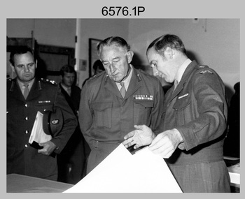
Photograph - Visit by MAJGEN David Engel AO OBE, to the Army Survey Regiment, Fortuna, Bendigo, 1982
This set of three photographs was taken the 30th of August 1982 during a visit to the Army Survey Regiment, Bendigo by the Deputy Chief of the General Staff - Major General David Frederick Walter Engel AO, OBE. As there are no annotations on the photo, the name of the Brigadier is unknown. LTCOL Peter Eddy was the CO of the Army Survey Regiment from 1981 to 1992 and handed over to LTCOL Jorge Gruszka, who commanded the unit from 1982 to 1985.This is set of three photographs taken on the occasion of a visit to the Army Survey Regiment, Bendigo by the Deputy Chief of the General Staff - Major General David Frederick Walter Engel AO, OBE on the 30th of August 1982. The black and white photograph was printed on photographic paper and are part of the Army Survey Regiment’s Collection. The photographic print was scanned at 300 dpi. .1) - Photo, black & white, 1982. Map production brief - L to R: unidentified Brigadier, unidentified visitor in background, MAJGEN David Engel AO OBE, CO LTCOL Peter Eddy. .2) - Photo, black & white, 1982. MAJGEN David Engel AO OBE views stereo aerial photography on a Wild B8 stereo plotter. .3) - Photo, black & white, 1982. Aerial photography brief - L to R: MAJGEN David Engel AO OBE, CO LTCOL Peter Eddy..1P to .3P –No personnel are identified. ‘Visit to ASR by MAJGEN Engel 30 Aug 1982’ annotated on cover sleeve.royal australian survey corps, rasvy, army survey regiment, army svy regt, fortuna -
 Eltham District Historical Society Inc
Film - Video (VHS), Dynavision Video Production, 1994 Eltham Festival, 11 Nov 1994
... venturers 3rd eltham brownies 1994 aerial photographs alistair knox ...20th Eltham Community Festival and last under the auspices of the Shire of Eltham. The Grand Parade focussing on the theme "Echoes of Eltham - Celebrating the visions of Eltrham from the past and into the future" was headed by Jock Read on his horse Lofty who had been filmed in an Anzac Day Parade on an earlier horse which had featured in the television show Matlock. The parade travelled north along Main Street to just past the Post Office then back south to Panther Place. Parade participants included 1st Eltham Brownies, 1st Eltham Venturers, 2nd Eltham Sea Scouts, 2nd Eltham Venturers, 3rd Eltham Brownies, Australian Democrats, Briar Hill Primary School, Circus Chaos, Country Fire Authority, Diamond Valley People for Disarmament, Diamond Valley Railway, Eltham Community Health Centre, Eltham District Horse and Pony Club, Eltham East Primary School, Eltham Fire Brigade, Eltham Junior Football Club (Panthers), Eltham Little Theatre, Eltham North Primary School, Eltham Playhouse Co-op, Eltham Pre-school, Eltham Roller Skating Club, Eltham South Pre-School Centre, Eltham Steam and Stationary Engine Society, Greenhills Neighbourhood House, Heidelberg Municipal Band, Hurstbridge Learning Co-op, Jocklebeary Farm, Kangaroo Ground Primary School, Learning Co-op Primary School, Lower Plenty Primary School, Main Road, Montmorency Gardening Club, Montmorency South Primary School, North Warrandyte Fire Brigade, Plenty Valley 88.6 FM, Research Pre-school, Research Primary School, Ron Sampson, Salvation Army Band (Briar Hill), Sherbourne Primary School, Shire of Eltham, State Emergency Service (Eltham) and Woodridge Pre-school. The parade commentary was provided by Plenty Valley FM 88.6 with guest commentator, Shire President Cr. John Graves. Following the parade is video footage from a helicopter of Alistair Knox Park, displays along Main Road and activities in Alistair Knox Park and the Rugby oval along with stationary engines, helicopter joyrides, Eltham People's Choir, music entertainment. Scenes also from the Diamond Valley Railway at Eltham Lower Park and finishing with the fireworks display. At the end of the video is a promotional video for Dynavision Video Production, a local video production company that produced the video and Diamond Photos (Kodak Express). One of the highlights of the festival was a tree planting ceremony in Alistair Knox Park to celebrate 123 years of the Shire of Eltham led by Shire President Cr. John Graves and representatives of the Wurrundjeri, traditional land owners of the area.VHS Video cassette (poor quality) Converted to MP4 file format 45:01, 535MB DVD copy of VHS cassette (better quality)1st eltham brownies, 1st eltham venturers, 2nd eltham sea scouts, 2nd eltham venturers, 3rd eltham brownies, 1994, aerial photographs, alistair knox park, arthur street, australian democrats, briar hill primary school, circus chaos, country fire authority, diamond valley people for disarmament, diamond valley railway, eltham community health centre, eltham district horse and pony club, eltham east primary school, eltham festival, eltham fire brigade, eltham junior football club (panthers), eltham little theatre, eltham lower park, eltham north primary school, eltham people's choir, eltham playhouse co-op, eltham pre-school, eltham roller skating club, eltham south pre-school centre, eltham steam and stationary engine society, grand parade, greenhills neighbourhood house, heidelberg municipal band, hurstbridge learning co-op, jock read, jocklebeary farm, john graves, kangaroo ground primary school, learning co-op primary school, lofty (horse), lower plenty primary school, main road, matlock police (tv show), montmorency gardening club, montmorency south primary school, nicholaus lauder estate, north warrandyte fire brigade, plenty valley 88.6 fm, research pre-school, research primary school, ron sampson, salvation army band (briar hill), sherbourne primary school, shire of eltham, state emergency service (eltham), video recording, woodridge pre-school -
 Port Melbourne Historical & Preservation Society
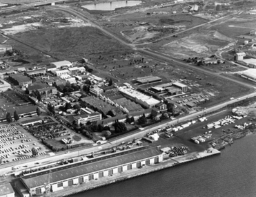
Photograph - Aerial view of Aeronautical Research Laboratories site from Yarra River, Early 1970s
... Transport - Aviation and Aerodrome Photograph Aerial view ...transport - aviation and aerodrome -
 Port Melbourne Historical & Preservation Society
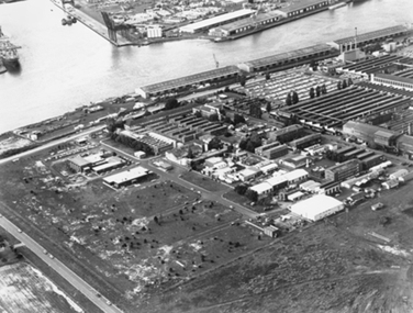
Photograph - Aerial view of Aeronautical Research Laboratories site from south-west, Early 1970s
... Transport - Aviation and Aerodrome Photograph Aerial view ...transport - aviation and aerodrome -
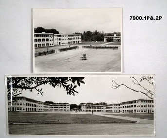 Bendigo Military Museum
Photograph - PHOTOGRAPH, SELARANG BARRACKS, 1970
Various photos of Selarang Barracks in Singapore in 1970. Some aerial and some ground level views. Refer items in Collection of LLoyd Farrell. Refer Cat 7889P.1. Photo of 1 RAR on parade for Trooping of the Colours in 1970 at Selarang Base in Singapore. Covering 'A' 'B' 'C' and Admin Company. 2. Extended portrait photo of the Parade Square and buildings of Selarang Base, Singapore in 1970. 3. Aerial photo of Selarang Barracks from a distance. 4. Aerial photo of Selarang Barracks 1970. 5. Aerial photo of Changi Prison 1970 in Singapore.Written on back. 1. "1 M1+" 2. “Selarang Barracks 1970 occupied by 1st RAR” 4. “Selarang 70” 5. 'Changi Prison 1970 Singapore'.photograhs, changi, selarang, 1970, lloyd farrell. -
 Port Melbourne Historical & Preservation Society
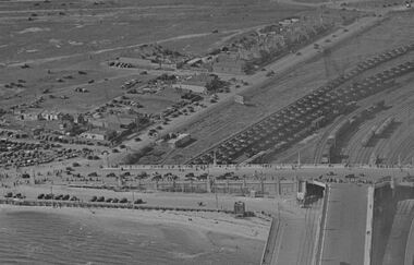
Photograph - Aerial view Centenary Bridge, Swallow St, forecourt Station Pier, Railyards
... was not the focus. Photograph Aerial view Centenary Bridge, Swallow St ...While there are many vehicles and pedestrians on the bridge and on Swallow Street, there is no action on the pier. Circa 1940Aerial view of Centenary Bridge, Swallow Street and Railyards. Circa 1940. Taken at same time as catalogue 5001 but with less view of Station Pier. An event of some sort had been on as there are many pedestrians and vehicles on Centenary Bridge and Swallow St, but it appears the pier was not the focus.piers and wharves, railyards, swallow street -
 Port Melbourne Historical & Preservation Society
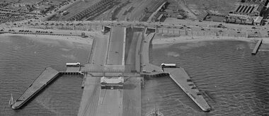
Photograph - Station Pier and surrounds c1940
It appears that there was some sort of event as there are many pedestrians and many vehicles on Centenary Bridge but very few on the pier. Circa 1940.Aerial photo approx 1940 showing Station Pier, Centenary Bridge, railyards and vehicles on Swallow St. piers and wharves - station pier, centenary bridge, transport - railways, swallow street -
Port Melbourne Historical & Preservation Society
Photograph - Aerial view 1960s of Piers and surrounds
... Photograph Aerial view 1960s of Piers and surrounds ... -
 Ballarat Heritage Services
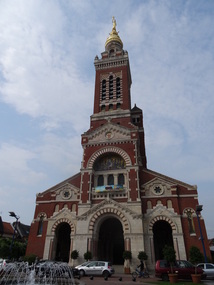
Photograph - Phtotograph - Colour, Ann Gervasoni, Church at Albert, The Somme, France, 2014, 23/07/2014
Albert was founded as a Roman outpost, in about 54 BC. After being known by various forms of the name of the local river, the Ancre, it was renamed to Albert after it passed to Charles d'Albert, duc de Luynes. It was a key location in the Battle of the Somme in World War I, and World War I tourism is important for the town. During World War I, the statue of Mary and the infant Jesus – designed by sculptor Albert Roze and dubbed the Golden Virgin – on top of the Basilica of Our Lady of Brebières was hit by a shell on 15 January 1915 and slumped to a near-horizontal position, where however it remained until further shelling in 1918 destroyed the tower. The German army recaptured the town in March 1918 during the Spring Offensive; the British, to prevent the Germans from using the church tower as a machine gun post, bombarded and destroyed the basilica.[5] The statue fell in April 1918 and was never recovered. Albert was completely reconstructed after the war, including widening and re-orienting the town's main streets. The Basilica, however, was faithfully rebuilt according to its original design by Eduoard Duthoit, the son of the architect who had overseen its construction in 1885–1895. The present statue is an exact replica of Roze's original design, and a war memorial designed by Roze and featuring an image of the Leaning Virgin can be seen in the Abri (Shelter) Museum, which houses souvenirs of the war. The underground shelters in which the museum is located served as protective bunkers for Albert's residents during aerial bombardments in World War II. (Wikipedia)Photographs of the Church at Albert taken during a tour of the World War One battlefields.albert, church, the somme, world war one -
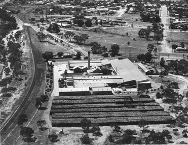 Stawell Historical Society Inc
Photograph, North Western Woollen Mills -- Aerial View Showing Wood pile and train line at left
North Western Woollen Mills -Framed - Aerial ViewLarge Framed Photograph stawell industry -
Stawell Historical Society Inc
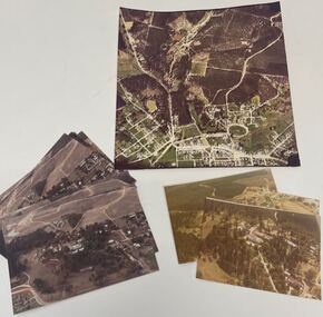
Photograph, Aerial Photo of Stawell 1981, 1981
Shows Railway Institute fire 1981. Swimming Pool in Cato Lake. Sawmill, King StreetVery Large Colour Print -
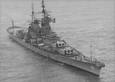 National Vietnam Veterans Museum (NVVM)
Photograph, Gibbons, Denis, USS New Jersey 1
Denis Gibbons (1937 – 2011) Trained with the Australian Army, before travelling to Vietnam in January 1966, Denis stayed with the 1st Australian Task Force in Nui Dat working as a photographer. For almost five years Gibbons toured with nine Australian infantry battalions, posting compelling war images from within many combat zones before being flown out in late November 1970 after sustaining injuries. The images held within the National Vietnam Veterans Museum make up the Gibbons Collection.A black and white photograph of the battleship USS New Jersey refurbished at a cost of US$27 million to engage targets, as far as thirty (30) miles inside North Vietnam. The New Jersey was recommisioned after President Nixon stopped the aerial bombing of the Northphotograph, tonkin gulf, president nixon, gibbons collection catalogue, uss new jersey, denis gibbons -
 Port Melbourne Historical & Preservation Society
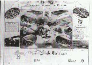
Photograph - Flight certificate given to passengers on Carey planes, 1920s
Sent by Carey's daughter Bertha Harvey during compilation of transport book "Linking "Us Together. (.01) lasercopy of aerial photo of Carey's Melbourne Air Service aerodrome on the Bend (Item .01 is absent from file as at Dec 2013) (.02) lasercopy of the Flight Certificate given to passengers on Carey planesfishermans bend, transport - aviation and aerodrome, r graham carey, melbourne air service -
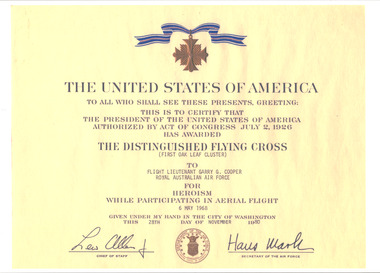 National Vietnam Veterans Museum (NVVM)
Document, United States of America, The Distinguished Flying Cross
On A4 gloss paper is the details from the United States of America of the Distinguished Flying Cross which was awarded to Flight Lieutenant Garry G. Cooper from Royal Australian Air Force for Heroism While Participating in Aerial Flight on the 6 May 1968. See photograph for more information on this award. The details are in black on a yellow background. There is a copy of a medal at the top of the document and it is signed by the Chief of Staff and Secretary of the Air Force. photocopy, flt lt g.g. cooper, garry cooper, 0219964, pilot, distinguished flying cross, australian force vietnam, raaf, united states of america, royal australian air force -
 Creswick Campus Historical Collection - University of Melbourne
Photograph - Aerial views of the Victorian School of Forestry Grounds and buildings, Victorian School of Forestry
... 1970s Photograph Aerial views of the Victorian School ...Three sets of Aerial views of the Victorian School of Forestry Grounds and buildings taken around the 1960s to early 1970s -
 National Vietnam Veterans Museum (NVVM)
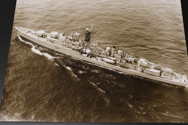
Photograph - Photograph, HMAS Vampire
During the Vietnam War, the HMAS Vampire repeatedly escorted the troop-carrier HMAS Sydney, which transported for Australian soldiers travelling to and from their service in Vietnam.An aerial b&w shot of HMAS Vampire at seaD11hmas, vampire, navy, vietnam, destroyer -
 Bendigo Historical Society Inc.
Photograph - Kangaroo Flat Gold Mine Collection: photo album 1998
Photo album, black cover, gold border. One hundred colour photos, some with annotations. Label on front of album: Portal, machinery, underground shots 1998; drilling in Deborah St.; mines rescue vehicle; various staff; E.E.S. Displays; Board Meeting 1998. Staff photos: Rob Charlton, pump at Red, White Blue Cons.; Andrew Breen Workshop Manager; John Cahill; Patrick O'Boyle Mine Rescue Vehicle; John Cahill; Ben Clayton; Ricky Hannah; April Westcott; Ivette Maggs site clerk McMahons; Wayne Woodward; Fiona Hunt; Steve Woodall.kangaroo flat gold mine, bendigo mining nl, new bendigo gold project, goldmining, personnel, doug buerger, colin burns, tarnagulla, new moon, displays, box cut, unity mining, aerial photos, 1998 -
 Bendigo Historical Society Inc.
Photograph - Kangaroo Flat Gold Mine Collection: photo album 1998
Photo album, red cover with black binding. Seventy colour photos, some with annotations. Label on front of album: 'Office Move 1998. Bendigo Show, E.E.S. Display, 'Board' on site 1998, Residents visit Tarnagulla, shaft shots, E.E.S Display Central Deborah, Drilling at New Moon, Box Cut (2), Aerial site photos Nov. 1998' Album includes mine personnel photos of Doug Berger, Geoff McDermott, John Cahill, Colin Burns, Ken Belfrage, Dean Turnbull, Courtney Chamberlain, 'The Boys' - Frank, Woody, Pratty and Jason, and Jason Bourke. Mining photos include: Carshalton site 24.7.98, drilling at New Moon and portal reef mining Tarnagulla 1998.kangaroo flat gold mine, bendigo mining nl, new bendigo gold project, goldmining, personnel, doug buerger, colin burns, tarnagulla, new moon, displays, box cut, unity mining, aerial photos -
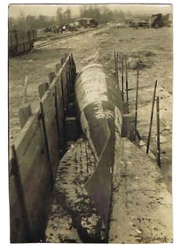 Bendigo Historical Society Inc.
Photograph - ROBERT DENIS KELLY COLLECTION: TORPEDO
Black and white photo: torpedo situated on ground with wooden wall on LH side. Written on back in pencil 'Peronne, a Fritz aerial torpedo, 15 ft. long, 18 inches diameter, 1 1/4 tons in weight'person, robert denis kelly, world war 1, france, torpedo. -
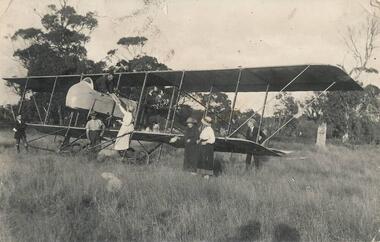 Phillip Island and District Historical Society Inc.
Photograph, 1920
Rhylston Park, an Italianate villa, was built in 1886 and the home of Mr Vaughan. One of a collection of over 400 photographs in an album commenced in 1960 and presented to the Phillip Island & Westernport Historical Society by the Shire of Phillip IslandPhotograph of an aeroplane and the first aerial bread delivery in Australia at Rhylston Park, Cowes, Phillip Island about 1920local history, photography, aeroplane, bread delivery, black & white photograph, air transport, john jenner, bryant west